

GORGE WIND FORECAST
If you’re still seeing yesterday’s and it’s after 9am, try opening this in an incognito window
today’s gorge wind forecast
Hi friends! In the next six days, we have four chances for wind. That’s pretty darn good for this late in the season! Something to keep in mind: clock change happens this weekend (sad), so the evening light will be pretty much gone.
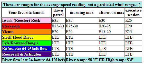
Let’s look at Tuesday morning. Pressures of 30.23/30.33/30.39 and east wind. For this morning, we’ll have E 35 at Iwash, E 30 at Stevenson, and E 20-25mph at Viento. The wind slowly fades this afternoon. For the evening: E 25mph at Iwash and E 20mph at Stevenson with 15mph at Viento. Overnight, the wind turns westerly. River flow over the last 24 hours was 64-101kcfs, river temp is 58.1F, and high temp forecast is 53F.
RIVER FLOW FOR SITES BETWEEN AVERY (EAST OF THE DALLES) AND RUFUS: CLICK HERE FOR JOHN DAY DAM FLOW.
RIVER FLOW FOR SITES BETWEEN STEVENSON AND DOUG’S BEACH (WEST OF THE DALLES): CLICK HERE FOR THE DALLES DAM FLOW

tomorrow’s gorge wind forecast
Wednesday sees a rainy cold front swing through early with west wind behind it. Models are not that impressed, and they also shut the wind off quickly as high pressure builds inland. Daybreak brings 12-15mph from Stevenson to Hood River, 10-13mph from Mosier to Doug’s, and 15-18mph from Avery to Rufus with less east of Rufus. I think we could see a period of 15-18mph from Stevenson to the Hatch before the wind fades in the afternoon. Models take the wind to zero mid-afternoon, but hey, it’ll be sunny! High temp: 58F.
extended Gorge wind forecast
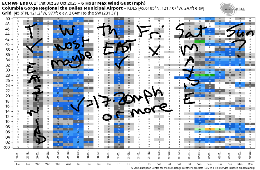
High pressure surges inland on Thursday, a cap sets up aloft, and the easterlies take over the Nch’i Wana. We’ll have 40mph at Iwash (Rooster) to start with 35mph at Stevenson and 25mph at Viento. 2pm wind looks like 35mph at Iwash and 30mph at Stevenson with 20mph at Viento. The wind continues to drop in the afternoon, but still stays over 20mph at Stevenson and over 30mph at Iwash, although it’ll likely be much gustier than in the morning. High temp: 55F with high clouds.
Friday brings calm wind. Saturday looks like light westerlies. There’s a chance of decent westerlies from Swell to Rufus on Sunday, but that’s pretty far in the future to be making a solid forecast call. We’ll keep a close eye on it. In the meantime… enjoy the easterlies!
Was that helpful? I knew it was! Guess what? All of this crucial work – from your personal wind and snow reports to the invaluable TATAS updates – is made possible by my relentless efforts. Maintaining this labor of love isn’t easy. Each daily forecast takes hours. Website hosting, weather model access, and back-end admin work takes time and money. That’s where you come in.
YOUR CONTRIBUTION MAKES A DIFFERENCE
- SUPPORT ACCURATE, HYPER-LOCAL WEATHER FORECASTING
- ENABLE ACCESS FOR ALL, EVEN THOSE WITH LESS MEANS
- SUPPORT A COOL HUMAN WHO WORKS HARD SO YOU CAN PLAY
Take a moment to click one of the buttons below. Donate $19.99 or more (how much does this forecast enhance your life?) and get the email in your inbox. Whether it’s a renewing subscription (auto-renew) or a one-time donation, every contribution makes a real difference. Help me keep this labor of love alive, so we can all continue playing, commuting, and living in the Gorge with peace of mind and the best weather forecasts possible. Thank you!


Hood River, Oregon 97031


MT HOOD SNOW FORECAST

Hi skiers and snowboarders! Kudos to those of you who were able to sneak out over the last couple of days and shred – I saw video from Four Bowl at Meadows and from Heather Canyon. I went skating at Teacup – so much appreciation for Jason getting out and grooming for those of us who are wildly passionate and willing to ski in marginal conditions. Thank you! That’s our last chance for pow turns or skategroom for at least a couple of weeks – the snow level is (with a brief exception tonight) going to stay above 5000′. Maybe we’ll get lucky with some early season corn, but it seems unlikely…
Anyway… Tuesday on Mt. Hood: cloudy all day with rain overnight and a trace of snow at the end. The snow level will be 9000′ this morning, 11,000′ this afternoon, and 4000′ overnight. About 0.4” water equivalent (WE) is forecast tonight, mostly as rain. Wind: S 15 this morning, SW 25 this afternoon, and WNW 20-25 overnight.
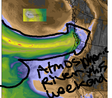
Partly cloudy sky early Wednesday turns clear in the afternoon. The free air freezing level rises from 4000′ in the morning to 11,000′ after midnight. Wind: NW 20 in the morning, NE 10 in the afternoon, and E 10-25 overnight. Thursday will be clear, warm, and windy (easterly). Friday: clear to start. The next weather system (a warm, wet one) arrives sometime late Friday or during the day Saturday. It taps into a strong atmospheric river. Depending on the exact aim of the fire hose, we could see 1.5-3.5” rain on the mountain. Bye for now, snow. We’ll see you again soon! Same goes for this Mt Hood snow forecast – it’s going back into hibernation until the next round of snow.
BARE BONES HOOD RIVER WEATHER FORECAST
Clouds this morning. Partly cloudy later. Rain late tonight. Temps start in the upper 30s and rise to the low 50s. Light easterlies. No rainbows. Wednesday will be rainy early and clear later. Temps start near 40 and rise to the upper 50s. Light to moderate westerlies becoming calm in the afternoon. 91% chance of rainbows. Thursday will be high overcast most of the day and clear late. Temps start in the mid 30s and rise to the mid 50s. Light easterlies. No rainbows.
TEMIRA’S AWESOME TRAVEL ADVISORY SERVICE
HYPERLOCAL WEATHER FORECAST FOR THE COLUMBIA GORGE
THE DALLES, HOOD RIVER, WHITE SALMON, TROUT LAKE, STEVENSON, CASCADE LOCKS, PARKDALE, ODELL, HUSUM, BZ, MILL A, WILLARD, GOLDENDALE, RUFUS, ARLINGTON, boardman
Good morning, neighbors! Beautiful sunrise this morning with the Nothing picking up up the color from aloft. Subtle, but still gorgeous. Next best chance for a spectacular sky snow looks like Thursday evening sunset. Other news: a couple days of strong east wind this week for folks in the Troutdale-Home Valley zone; a shift to a dry forecast for Halloween; heavy rain likely for parts of this weekend. And the time change. Dumb. If Congress was useful at all, they’d actually move on the west coast’s passage of laws regarding time changes. My vote is for DST all year round. KEEP EVENING LIGHT AGAIN!
Glenwood this morning
As we always do, we’ll check in with Glenwood. 32 degrees there this morning. Everyone in Glenwood is praying for the folks in Jamaica this morning. If they’re not prayer people, they’re sending metta. If that’s not their thing, they’re sending money to relief organizations. Or other actions. The only thing they’re not doing is turning away from what’s happening. The very least we can all do is bring a sense of care to what’s happening to Jamaica. And to folks here at home affected by the horrors of our administration’s hate: POC, LGBTQ folks, immigrants, people with low incomes, disabled folks… sadly, the list goes on.
Please support local food banks
Here’s something y’all can do: if you have the financial ability, please, please, please make a cash donation to your local food bank. You can also donate food, but money is much more efficient for food banks. Even if it’s just a little bit of money. It will help.
Chinook Campus Pantry (at CGCC in The Dalles)
We all need to step up here to help our neighbors feed themselves and their kids. Also, shame on Congress for passing huge cuts to food benefits while passing massive tax cuts for billionaires in the Big Ugly Bill.
Today’s Gorge weather forecast
Weather today: cloudy to start, partly cloudy later with partly low clouds in the west and partly high cloudy conditions to the east. Temps climb to 53F-56F in the lowlands with the freezing level rising to 9000′ this afternoon. Down on the river: Iwash (dong) Rock has easterlies at 35mph this morning and 25mph this afternoon. Stevenson: 30mph this morning and 20mph this afternoon. The wind dies down overnight and switches to westerly with the arrival of a cold front.
Wednesday’s Gorge weather forecast
This drops steady, moderate rainfall as far east as The Dalles between 2am Wednesday and 5am Wednesday. The rain slides east after that and leaves us all dry with clearing skies. Wind will be westerly at 15mph in the morning, and it’ll die off in the afternoon thanks to high pressure building inland. High temps: 58-62F. Freezing level: 4000′ early and 9000′ in the afternoon.
Thursday’s Gorge weather forecast
On Thursday, that high pressure digs in over the Columbia Basin for a dry day. Near the giant basalt dong, east wind will be 40mph in the morning and 30-35mph in the afternoon. Stevenson: 35mph in the morning and 25mph in the afternoon. To the east: lighter wind. Hills: 10-25mph depending on elevation. Other Thursday news: the sky starts high overcast and turns clear. Temps rise to 55F-58F.
Halloween Gorge weather forecast (and beyond)
Our most important day this week is Friday. Why? Halloween! Earlier in the week, we had a forecast of pouring rain for Halloween evening. Models now hold the rain off until after the kids are done trick or treating. Good! Nobody likes a soaking wet, hypothermic, sugar-addled kiddo! Rain continues into Sunday morning before tapering off. More deets on this weather system: it’s tapping in to an atmospheric river, potentially a very strong one. Rainfall forecast still has a huge range, so I’ll hold off on making predictions. One thing we can see looking at the PWAT (available moisture) model is that we’re going to get penetrated, potentially fucked hard, by this shaft of moisture. Gotta love the Pineapple Express – it almost always looks like a cock and allows all of us forecasters to act like 12 year old boys. Safe travels. -TATAS
HEY! DON’T STOP READING! Is this community-focused forecast helpful to you? It sure is! It takes me a couple hours a day to write. Please join your friends and neighbors in contributing to keep it going. Venmo: @thegorgeismygym PayPal: twomirrors@gmail.com USPS: Temira / PO Box 841 / Hood River, Oregon 97031 You can test out the forecast subscription for a few days for free by signing up below. Easy! Do it!
JONES BEACH, SAUVIE ISLAND, & COAST FORECAST
ON WINTER BREAK. MAY SHOW UP OCCASIONALLY.
