

GORGE WIND FORECAST
If you’re still seeing yesterday’s and it’s after 9am, try opening this in an incognito window
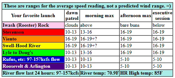
today’s gorge wind forecast
Hi friends! We’re set for a couple more days of westerlies in the just-enough zone. Stronger wind returns on Thursday and sticks around through at least Saturday and probably through Sunday. We’ll have hot weather (85+ in my book) through Thursday followed by a few degrees less heat for the Friday-Sunday stretch.
PSAs: while Doug’s Beach has been downgraded to Level 2, fire crews have requested we not recreate in the river in the fire zone. Planes have been scooping water in locations between Tunnel 4 and Doug’s depending on the day. If you see planes/helicopters scooping near where you’re recreating, please leave and go elsewhere.
All righty. Tuesday’s forecast: the day started with pressures of 30.00/29.94/29.92 for gradients of 0.06/0.02. West wind was blowing 16-19mph between Viento and the White Salmon Bridge. Elsewhere, the wind was under 15mph. We’ll see the wind hold at 16-19mph this morning between Viento and Swell. IT should fill in between Stevenson and Doug’s this afternoon. Thanks to enthusiastic marine clouds in the metro area this morning, it’s possible we could see a period of 19-22mph from Viento to Mosier if the clouds hold longer than models predict. River flow over the last 24 hours was 97-157kcfs, river temp is 70.9F, and high temp forecast is 85F for Hood River.
RIVER FLOW FOR SITES BETWEEN AVERY (EAST OF THE DALLES) AND RUFUS: CLICK HERE FOR JOHN DAY DAM FLOW.
RIVER FLOW FOR SITES BETWEEN STEVENSON AND DOUG’S BEACH (WEST OF THE DALLES): CLICK HERE FOR THE DALLES DAM FLOW

tomorrow’s gorge wind forecast
Wednesday looks like another just-enough day: we’ll start with 11-14 form Viento to Swell with less than 10mph everywhere else along the river. By late morning, we’ll have 14-17 from Stevenson to Doug’s with 5-10mph out into the desert. Afternoon wind rises to 18-21mph from Stevenson to Avery with 14-17mph from Swell to Hood River. High temp: 91F for Hood River.
extended Gorge wind forecast
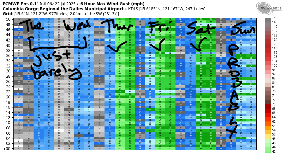
An approaching trough (cool air) knocks the west side temps down a bit on Thursday. Out in the desert: heat continues to build. This improved cross-Cascade temp gradient gives us stronger wind: 19-22 from Viento to Mosier to start with 15mph at Stevenson and also between Lyle and Avery. Mid-morning wind rises to 22-25mph from Stevenson to Avery. Afternoon: wind between the Hatch and Hood river depends on what the metro area clouds do. Areas between Mosier and Arlington rise to 25-28mph in the afternoon. Stevenson should hold at 22-25mph. Similarly strong wind is in the forecast Friday and Saturday. Sunday looks a bit lighter, but should still bring us low to mid 20s. That’s all for now. Have a great day on the river!
Was that helpful? I knew it was! Guess what? All of this crucial work – from your personal wind and snow reports to the invaluable TATAS updates – is made possible by my relentless efforts. Maintaining this labor of love isn’t easy. Each daily forecast takes hours. Website hosting, weather model access, and back-end admin work takes time and money. That’s where you come in.
YOUR CONTRIBUTION MAKES A DIFFERENCE
- SUPPORT ACCURATE, HYPER-LOCAL WEATHER FORECASTING
- ENABLE ACCESS FOR ALL, EVEN THOSE WITH LESS MEANS
- SUPPORT A COOL HUMAN WHO WORKS HARD SO YOU CAN PLAY
Take a moment to click one of the buttons below. Donate $19.99 or more (how much does this forecast enhance your life?) and get the email in your inbox. Whether it’s a renewing subscription (auto-renew) or a one-time donation, every contribution makes a real difference. Help me keep this labor of love alive, so we can all continue playing, commuting, and living in the Gorge with peace of mind and the best weather forecasts possible. Thank you!


Hood River, Oregon 97031


JONES BEACH, SAUVIE ISLAND, & COAST FORECAST
Wind northerly unless otherwise indicated. For coast, it’s North/Central/South with the “central” at approximately Florence. Swell forecast from NWS for central coast. Jones: westerly unless otherwise stated. Sauvie Island: northerly unless otherwise stated. Coast Tuesday: NNW10-15/N15/20-25, NW swell 4′ at 10 seconds. Wednesday: NNW 10-15/N10-15/N10-15, NW 3′ @ 9. Thursday: NNW10/NNW10-15/LTNW, NW 3′ @ 9. Jones Tuesday: 11-14. Wednesday: 19-22. Thursday: 20-23. Sauvie Island Tuesday: 9-12. Wednesday: 10-13. Thursday: 10-13.
BARE BONES HOOD RIVER WEATHER FORECAST
Clear sky this morning adds a few little clouds later. Temps start in the low 60s and rise to the mid 80s. Moderate westerlies. No rainbows. Wednesday will be mostly clear then clear. Temps start in the low 60s and rise to the low 90s. Moderate westerlies. No rainbows. Thursday will be mostly clear then clear. Temps start in the low 60s and rise to the upper 80s. Moderately strong westerlies. No rainbows.
TEMIRA’S AWESOME TRAVEL ADVISORY SERVICE – TUESDAY 7/22
HYPERLOCAL WEATHER FORECAST FOR THE COLUMBIA GORGE
THE DALLES, HOOD RIVER, WHITE SALMON, TROUT LAKE, STEVENSON, CASCADE LOCKS, PARKDALE, ODELL, HUSUM, BZ, MILL A, WILLARD, GOLDENDALE, RUFUS, ARLINGTON, boardman

Good morning, neighbors! Another sunny summer day is on tap today, and it starts with hopeful news on the Burdoin Fire: according to WatchDuty (and math), the fire only grew by 200 acres yesterday. It’s still listed as 0% contained, but the fire crews are doing an amazing job of limiting growth. THANK YOU FIRE CREWS! Weathert this week: warm and sunny with moderate westerlies for a few days. Somewhat cooler weather (under 90 west of The Dalles) returns Friday, but stronger westerlies arrive then too in response to the cooling.
GLENWOOD THIS MORNING
There are lots of deets to that forecast to discuss, but first we discuss Glenwood: 47 degrees to start the day, which was 16 degrees cooler than at my house. At my house, people (me, to be specific), were sleeping in. Up in Glenwood, everyone was up with the sun because that’s the best time to moo at the cows and get a response in English.
TODAY’S GORGE WEATHER FORECAST
For the rest of today for the rest of us, temps build: 85 degrees is forecast on the west side and 90 degrees from The Dalles eastward. West wind starts at 10-15mph between Stevenson and Mosier (10mph near Rowena) and rises to 15-20mph between Stevenson and The Dalles. East of The Dalles, westerlies will be around 10mph all day. Some lingering atmospheric instability along the Cascade Crest and areas to the east and north may fire off a few little fluffy clouds this afternoon. Models have the possibility of some thundershowers near Satus Pass.
Overnight, the sky will be mostly clear. Go stare at the sky. You might see meteors from the Southern Delta Aquarids, the Alpha Capricornids, and the Perseids. It’ll be a nice night for it: relatively warm with very little wind.
WEDNESDAY’S GORGE WEATHER FORECAST
Wednesday looks too warm for TATAS: after a 60 degree start, temps rise to 90 (est) and 95 (The Dalles and areas to the east). West wind will be 10-15mph from Viento to Underwood early with 15-20mph from Stevenson to Avery in the afternoon. A few low clouds are possible west of Cascade Locks early in the morning, but other than that, we should have clear sky.
EXTENDED GORGE WEATHER FORECAST
An approaching trough of cool air on Thursday knocks temps down a few degrees and drives the west wind higher. The day starts in the upper 50s to low 60s. Afternoon heat: 87 (west), 92 (The Dalles), and 97 (Hermiston watermelon zone). Westerlies start at 20mph between Viento and Mosier with 10-15mph west of Viento and 15mph east of Mosier to Avery. Afternoon: 20-30mph from Stevenson to Arlington, strongest between Mosier and Rufus. Similar wind but slightly cooler weather is forecast Friday, Saturday, and Sunday. High temps drop a couple degrees each day.
Between now and Sunday, no rain is forecast. Neither is any snow, ice, nor sleet. Know what is in the forecast? Cherry pie – pie cherries are coming ripe RIGHT FUCKING NOW in Odell. Speaking of cherries… I learned something the other day: they’re full of sorbitol. The riper they are, the more they contain. Sorbitol is a laxative. Don’t eat too many overripe cherries unless you are seeking an experience similar to a colonoscopy prep. This right here is probably why most of the cherries you buy in a store are under-ripe. Definitely don’t eat a bunch of overripe cherries before driving. Safe travels. -TATAS
HEY! DON’T STOP READING! Is this community-focused forecast helpful to you? It sure is! It takes me a couple hours a day to write. Please join your friends and neighbors in contributing to keep it going. Venmo: @thegorgeismygym PayPal: twomirrors@gmail.com USPS: Temira / PO Box 841 / Hood River, Oregon 97031 You can test out the forecast subscription for a few days for free by signing up below. Easy! Do it!
