

GORGE WIND FORECAST
If you’re still seeing yesterday’s and it’s after 9am, try opening this in an incognito window
today’s gorge wind forecast
Hi friends! Not much is happening out there this morning, but a big pattern shift tomorrow brings us the opposite: nuking westerlies. Strong wind sticks around Thursday before something totally different dominates the picture: Rain. From Friday through the weekend, models have westerlies right on the edge of “enough”, and you’ll likely need to be east of Hood River to take advantage of it.
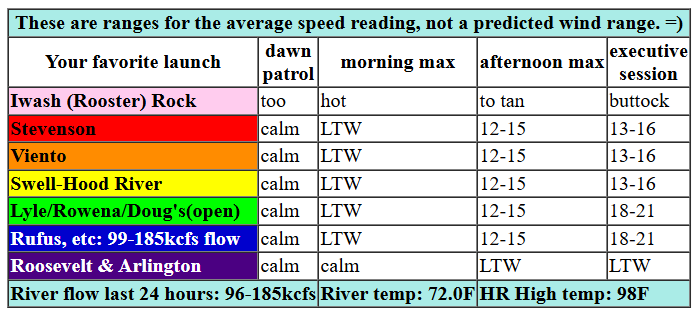
There won’t be much wind on Tuesday for you to take advantage of. Early gradients were just barely onshore (0.01 PDX-DLS), and the wind was nearly calm all through the Gorge. Desert heat outpaces metro area heat (barely) this afternoon and turns the westerlies on. By early afternoon, we should have 12-15mph from Stevenson to Swell with 7-10mph from Hood River to Mosier. Models keep Swell in the 13-16mph range through the evening and take the Mosier-Rufus stretch to 18-21mph. River flow over the last 24 hours was 96-185kcfs, river temp is 72.0F (poor salmon), and high temp forecast is 98F for Hood River and low triple digits near Rufus.
RIVER FLOW FOR SITES BETWEEN AVERY (EAST OF THE DALLES) AND RUFUS: CLICK HERE FOR JOHN DAY DAM FLOW.
RIVER FLOW FOR SITES BETWEEN STEVENSON AND DOUG’S BEACH (WEST OF THE DALLES): CLICK HERE FOR THE DALLES DAM FLOW

tomorrow’s gorge wind forecast
Overnight, a trough (cooler air) slides south from BC and settles in on the west side. Models are struggling to clarify the depth/extent of marine clouds on Wednesday morning, and that will make a difference in where the strongest wind sets up. In an interesting twist, the deterministic Euro this morning keeps the clouds coming through late morning. That is good! The day starts with 22-25mph from Viento to Mosier with 13-16mph near Rowena and 18-21mph from Avery to Arlington. Stevenson: likely cloudy with gusty 12-15mph. By late morning (depending on the cloud line location) or early afternoon, we’ll have 27-30mph from Viento to Rufus with 18-21mph near Rowena and 23-26mph from Avery to Arlington. Afternoon: 23-26mph at Stevenson, 27-30mph from Viento to Mosier, and 31-34mph from Lyle to Arlington. Threemile and Boardman join mid afternoon. High temp: 83F for Hood River, 90F for Arlington, and 98F for Boardman with full-on sunshine everywhere by afternoon. What a day it’s going to be!
extended Gorge wind forecast
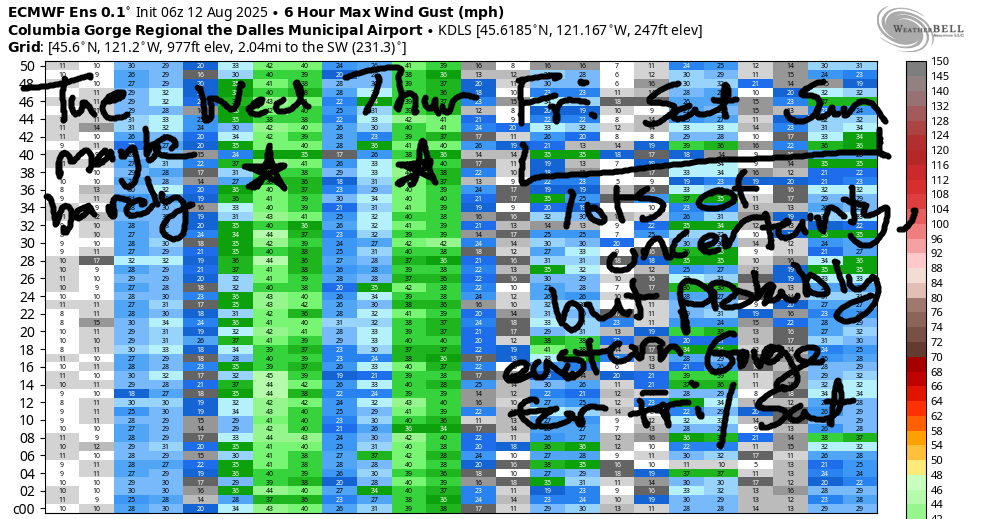
Cool air lingers on the west side Thursday as a reinforcing trough and associated frontal system impact the area. In plain English, we’ll have solid morning clouds on the west side and a few passing high clouds in the desert. All these moving pieces are likely to make the wind gustier than we’ll see Wednesday, but it’ll still be strong. Early wind will be 20-23mph from Viento to Mosier with 11-14mph near Rowena and 21-24mph from Avery to Arlington. Stevenson will be cloudy with gusty teens. Westerlies take a bit longer to get going, but they will: 26-29mph from Viento to Arlington by late morning or early afternoon with 21-24mph at Stevenson. Models suggest Swell-Hood River will drop in the afternoon as the sky clears and an approaching system disrupts the wind field. At that point, we’re looking at 20-23mph from Stevenson to Viento, 18-21mph from Swell to Hood River, and 28-31mph from Lyle to Arlington. High temp: 77F for Hood River and 85F at Rufus.
Rain arrives from the west on Friday morning, and cool air pushes all the way to the desert. There’s quite a bit of range in the wind ensembles for Friday, but the general picture is lighter-than-Thursday and definitely east of Hood River for best results. For now, let’s call it 18-21mph east of The Dalles. Similar conditions are forecast for Saturday. Sunday’s wind (probably) shifts back to the Corridor (near Hood River) and Near East (near Rowena), but the strength remains in the 17-20ish zone. Uncertainty increases after the weekend, but moderate westerlies are almost certain to continue; there’s no sign of no-wind days in the ensembles. Stay cool today, and I’ll see you on the Nch’i Wana tomorrow!
Was that helpful? I knew it was! Guess what? All of this crucial work – from your personal wind and snow reports to the invaluable TATAS updates – is made possible by my relentless efforts. Maintaining this labor of love isn’t easy. Each daily forecast takes hours. Website hosting, weather model access, and back-end admin work takes time and money. That’s where you come in.
YOUR CONTRIBUTION MAKES A DIFFERENCE
- SUPPORT ACCURATE, HYPER-LOCAL WEATHER FORECASTING
- ENABLE ACCESS FOR ALL, EVEN THOSE WITH LESS MEANS
- SUPPORT A COOL HUMAN WHO WORKS HARD SO YOU CAN PLAY
Take a moment to click one of the buttons below. Donate $19.99 or more (how much does this forecast enhance your life?) and get the email in your inbox. Whether it’s a renewing subscription (auto-renew) or a one-time donation, every contribution makes a real difference. Help me keep this labor of love alive, so we can all continue playing, commuting, and living in the Gorge with peace of mind and the best weather forecasts possible. Thank you!


Hood River, Oregon 97031


JONES BEACH, SAUVIE ISLAND, & COAST FORECAST
Wind northerly unless otherwise indicated. For coast, it’s North/Central/South with the “central” at approximately Florence. Swell forecast from NWS for central coast. Jones: westerly unless otherwise stated. Sauvie Island: northerly unless otherwise stated. Coast Tuesday: LTNW/NNW10-15/LTN, NW swell 7′ at 10 seconds and SW 2′ at 16 seconds. Wednesday: LTNW/N10-15/N25-30, NW 6′ @ 9 and SW 3′ @ 15. Thursday: SW10-15/LTV/N25-30, NW 4′ @ 8 & SW 2′ @ 15. Jones Tuesday: 18-21. Wednesday: 8-11. Thursday: LTV. Sauvie Island Tuesday: 10-13. Wednesday: NNW14-17. Thursday: 5-8.
BARE BONES HOOD RIVER WEATHER FORECAST
Clear today. Temps start in the mid 60s and rise to the upper 90s. Moderate westerlies. No rainbows. Wednesday will be mostly clear with a few low clouds then sunny. Temps start in the upper 60s and rise to the low 80s. Strong to very strong westerlies. No rainbows. Thursday will be mostly cloudy then clear. Temps start near 60 and rise to the mid/upper 70s. Moderately strong westerlies. No rainbows.
TEMIRA’S AWESOME TRAVEL ADVISORY SERVICE
HYPERLOCAL WEATHER FORECAST FOR THE COLUMBIA GORGE
THE DALLES, HOOD RIVER, WHITE SALMON, TROUT LAKE, STEVENSON, CASCADE LOCKS, PARKDALE, ODELL, HUSUM, BZ, MILL A, WILLARD, GOLDENDALE, RUFUS, ARLINGTON, boardman
Good morning, neighbors! Another hot AF day is on tap today. You’ve got this! This is the last of the super-hot days for the west side for the foreseeable future. The foreseeable future is 10-14 days out. And beyond that, I’ll be on retreat for a week or so and the weather won’t make a whit of difference to me! Between now and retreat time, something rad will happen: rain, at least for many of us. Let’s dive in to all this excitement together, shall we?
glenwood this morning
First off, checking in with Glenwood. I’m starting to feel a need for a summer home there to support my sleep. Peeps in Glenwood woke up to 53 degrees this morning. So did the humans. Both were a bit stiff, the Peeps because they’re stale (Easter was long ago), and the humans because they’re aging, like all humans do.
today’s gorge weather forecast
The rest of us woke up in the upper 50s (Odell) to the low 70s (many locations along the Nch’i Wana). Temps rise to the upper 90s today (west) and low triple digits (The Dalles and areas to the east). This should send you scurrying for a swimming hole, an air-conditioned ice cream aisle, or the cold storage unit owned by a friendly orchardist. Craig, I’m talking to you! Calm wind this morning turns breezy this afternoon: 15mph or so between Stevenson and Hood River with 15-20mph from Mosier to (eventually) Rufus, where the wind will feel like a convection oven thanks to too many digits (three, to be exact) in the thermometer reading.
wednesday’s gorge weather forecast
A very, very, very different day is in the cards for Wednesday. Please, for the love of this place we call “home” be very careful with sparks and fires on Wednesday. If you observe someone doing something irresponsible with yard implements, trailer chains, trains, fireworks, fire, or “combustion smoking”, which is an awkward term that covers cigarettes, joints, pipes, bongs, and carved-out-apples, speak up. While 10-15 degrees of cooling is forecast, it’ll be accompanied by west wind at 30mph or more all the way from Stevenson to Boardman by the afternoon. Wind that strong will spread fire as fast as a cheetah can run or a Wind Johnny can drive. Have a plan in place if you’re somewhere with a tricky exit. Wednesday’s non-fire weather starts cloudy on the west side and clear east of Hood River. Temps will be in the upper 60s or warmer most places to start. In the afternoon, they rise to the low 80s (west side, and near 15 degree cooler than Tuesday), low 90s for The Dalles, and upper 90s out near Boardman.
thursday’s gorge weather forecast
Even cooler weather is forecast on Thursday. Westerlies continue. In the morning, we’ll have deep low clouds as far east as Viento or Hood River with clear sky to the east. Westerlies will be 20-25mph all the way from Stevenson to Arlington to start the day. Mostly clear sky returns for all of us in the afternoon, and all of us end up with westerlies at 25-30mph. Max temps: upper 70s (heck yeah!) for the west side, low 80s near The Dalles, and upper 80s in the far east desert where the watermelons will be crying and begging for jackets. But not Yellow Jackets. Nobody begs for them.
extended gorge weather forecast
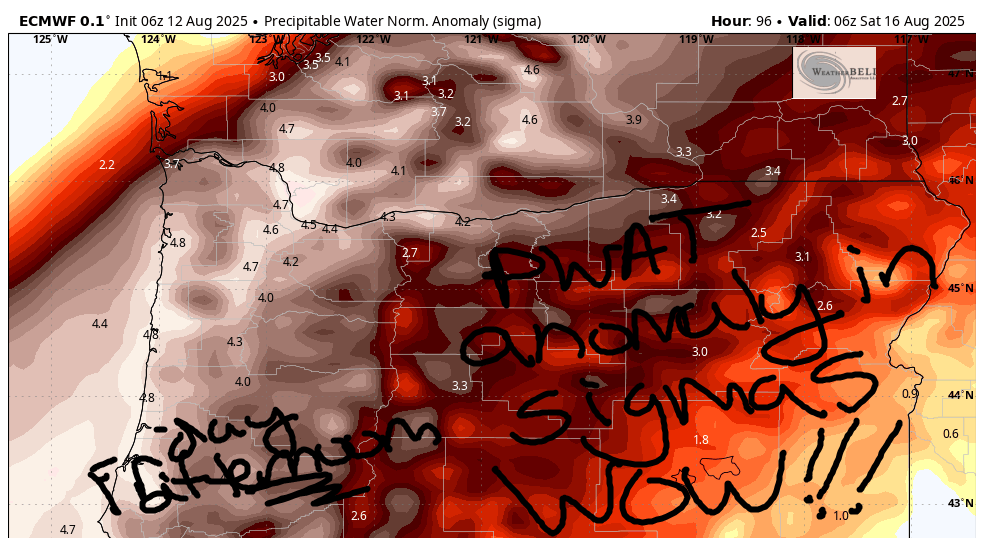
Friday looks just-plain-awesome. Rain is likely west of The Dalles and perhaps even to the east. Models are all over the place on rain totals, but they’re very aggressive with rain totals along the Cascade Crest: half an inch or more for the mountains! Down here in the lowlands, for the Friday-Saturday period, we currently have … Cascade Locks: 0.45” to 0.80”; The Dalles: trace to 0.2”. Why so wet? The answer is two-fold: a shitton (technical term) of available moisture and systems moving through to squeeze the moisture out of the air.
How moist will it be? Definitely moister than my dried-up-peri-menopausal … you-thought-I-was-gonna-say-vag*na. On the ground, this looks less like a snail trail and more like these numbers: dewpoints of 56-65 degrees; PWAT of 1.43-1.81”, 197-229% of normal, and 3.4-4.7 sigmas!!! Holy shit! That’s wet! With this much moisture, rainfall is likely to exceed model predictions. In addition, temps will be way down. Highs Friday: 71/78/83 (west/Dallesport/desert). Highs Saturday: 74/81/85. Sunday: 76/83/86. On all three days, west wind will be 15-20mph(ish, subject to change some). Two rounds of rain air likely: Thursday night into Friday and also Saturday morning.
Beyond this super-duper-exciting period of rain, we’ve got rather cool temps in the ensembles for the next 10-14 days. There’s about 10 degrees of range in the possible highs (lots of uncertainty, in other words), but they (mostly) keep The Dalles under 90 degrees through the 26th. That, of course, could change given the extensive uncertainty. So don’t get irrationally exuberant. Safe travels. -TATAS
HEY! DON’T STOP READING! Is this community-focused forecast helpful to you? It sure is! It takes me a couple hours a day to write. Please join your friends and neighbors in contributing to keep it going. Venmo: @thegorgeismygym PayPal: twomirrors@gmail.com USPS: Temira / PO Box 841 / Hood River, Oregon 97031 You can test out the forecast subscription for a few days for free by signing up below. Easy! Do it!
