

GORGE WIND FORECAST
If you’re still seeing yesterday’s and it’s after 9am, try opening this in an incognito window
today’s gorge wind forecast
Hi friends! Another “maybe” day is on tap today with a couple more days of “maybe” Wednesday and Thursday. Not much wind is in the Gorge wind forecast for Friday. Looking at the weekend, we see a more active weather pattern. While this sets us up for stronger west wind – especially Saturday – it also puts us at risk for thunderstorms and associated disruptions of the wind field. As I’ve mentioned before, I’m heading out on a retreat Friday morning and will not be forecasting Saturday through the following Thursday. I look forward to seeing you when I return! I hope it’s windy for you every single day I’m gone!
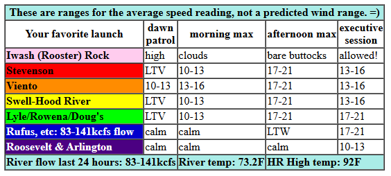
Looking at Tuesday (today!), we have a shot at “just enough” this afternoon, but our chances are impacted by the thing driving the wind: a potentially storm-causing system moving into the region from the south. Tuesday started with pressures of 29.89/29.86/29.85 for gradients of 0.03 and 0.01. Viento was reading 11mph on the iWind/iKite sensor as I was typing this forecast. Everywhere else: light/variable. We’ll see a slow build to 13-16mph between Stevenson and Swell by early afternoon. To the east: 5-10mph or less. As the system I mentioned moves north mid-afternoon, there’s a chance of gusty 17-21mph from Stevenson to Doug’s. Given the instability along the Cascade Crest and chance of thunderstorms, it’s entirely possible the Stevenson-Mosier zone will shut down. East of The Dalles this afternoon: basically nothing. River flow over the last 24 hours was 83-141kcfs, river temp is 73.2F, and high temp forecast is 92F (but we will probably be cooler).
RIVER FLOW FOR SITES BETWEEN AVERY (EAST OF THE DALLES) AND RUFUS: CLICK HERE FOR JOHN DAY DAM FLOW.
RIVER FLOW FOR SITES BETWEEN STEVENSON AND DOUG’S BEACH (WEST OF THE DALLES): CLICK HERE FOR THE DALLES DAM FLOW

tomorrow’s gorge wind forecast
Moving on to Wednesday… it’s another “maybe just enough” kind of day. We’re faced, once again, with instability, but that should calm down in the afternoon. Early in the morning, barring thunderstorms, we’ll have 15-18mph from Stevenson to Arlington. Late morning wind builds to 17-20mph from Stevenson to Doug’s and drops to 10-13mph east of Doug’s. In the afternoon, models hint at a precipitous drop-off west of Mosier – 11-14mph – with 19-22mph from Mosier to Rufus. High temp: 86F in Hood River and 91F in Rufus.
extended Gorge wind forecast
Thursday sees the desert heat low collaborating, or perhaps commiserating, with a weak low offshore. Some models hint at a brief bout of marine clouds in the western Gorge. Maybe. We start with 17-20mph from Stevenson to Swell. The wind quickly drops to 13-16mph by mid-morning. From mid-afternoon on, we’re looking at 10-13mph west of Mosier and east of Doug’s with 17-20mph from Mosier to Doug’s. High temp: 89F.
Brief high pressure takes command on Friday. Westerlies look to be around 15mph at best, strongest form Stevenson to the Hatch. Saturday and Sunday look windier, especially Saturday, but lots of moving pieces suggest gusty, tricky, potentially unreliable wind. We’ll take a closer look as we get closer to the weekend. Again, I’ll get a forecast out on Friday, and then I’m off on a silent retreat through the following Thursday. Yay! Hope to see you on the Nch’i Wana today!
Was that helpful? I knew it was! Guess what? All of this crucial work – from your personal wind and snow reports to the invaluable TATAS updates – is made possible by my relentless efforts. Maintaining this labor of love isn’t easy. Each daily forecast takes hours. Website hosting, weather model access, and back-end admin work takes time and money. That’s where you come in.
YOUR CONTRIBUTION MAKES A DIFFERENCE
- SUPPORT ACCURATE, HYPER-LOCAL WEATHER FORECASTING
- ENABLE ACCESS FOR ALL, EVEN THOSE WITH LESS MEANS
- SUPPORT A COOL HUMAN WHO WORKS HARD SO YOU CAN PLAY
Take a moment to click one of the buttons below. Donate $19.99 or more (how much does this forecast enhance your life?) and get the email in your inbox. Whether it’s a renewing subscription (auto-renew) or a one-time donation, every contribution makes a real difference. Help me keep this labor of love alive, so we can all continue playing, commuting, and living in the Gorge with peace of mind and the best weather forecasts possible. Thank you!


Hood River, Oregon 97031


JONES BEACH, SAUVIE ISLAND, & COAST FORECAST
Wind northerly unless otherwise indicated. For coast, it’s North/Central/South with the “central” at approximately Florence. Swell forecast from NWS for central coast. Jones: westerly unless otherwise stated. Sauvie Island: northerly unless otherwise stated. Coast Tuesday: NNW10/NNW10-15/N20-25, NW swell 5′ at 8 seconds. Wednesday: LTW/LTNW/LTN, NW 4′ @ 7. Thursday: LTW/LTW/LTV, NW 3′ @ 7. Jones Tuesday: 15-18. Wednesday: 12-15. Thursday: 15-18. Sauvie Island Tuesday: 10-13. Wednesday: LTN. Thursday: LTN.
BARE BONES HOOD RIVER WEATHER FORECAST
Partly cloudy this morning and partly cloudy later with a chance of thunderstorms. Temps start in the upper 60s and rise to the low 90s (depends on cloud cover – likely less hot). Muggy. Light westerlies early. Moderate later. 1.5% chance of rainbows. Wednesday will be mostly clear then clear. Temps tart in the upper 60s and rise to the mid 80s. Moderate westerlies. No rainbows. Thursday will be clear in the morning with a few mid-level clouds later. Temps start in the mid 60s and rise to the upper 80s. Moderate westerlies. No rainbows.
TEMIRA’S AWESOME TRAVEL ADVISORY SERVICE – TUESDAY 8/26
HYPERLOCAL WEATHER FORECAST FOR THE COLUMBIA GORGE
THE DALLES, HOOD RIVER, WHITE SALMON, TROUT LAKE, STEVENSON, CASCADE LOCKS, PARKDALE, ODELL, HUSUM, BZ, MILL A, WILLARD, GOLDENDALE, RUFUS, ARLINGTON, boardman
Good morning, neighbors! Hot, muggy weather (by my definition, anyway) continues for a few more days. After that: not exactly cool, but not exactly hot. For the weekend, temps moderate a bit (85-90), west wind picks up, and a(nother) chance of thunderstorms enters the weather picture. Beyond that, chaos rules the models – uncertainty remains quite high for the extended forecast. Uncertainty can be hard to tolerate. Take care of yourself.
Glenwood this morning
Looking at Glenwood this morning, everyone is taking good care of themselves. The day started at 57 degrees with a dewpoint of 52 degrees for a relative humidity of 83%. Anyone out jogging this morning is sweating. Anyone sitting on the porch in a rocking chair is sweating. Anyone bumping uglies is sweating. Anyone milking the chickens, gathering the cow eggs, and shearing the goats is sweating. Stay hydrated today, folks, even folks not-in-Glenwood. It’s going to be hot, muggy, and dehydrating out there!
Today’s Gorge weather forecast
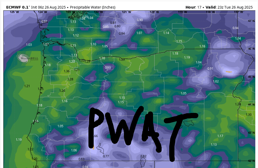
Here’s what we have on tap today: quite the spectacular mix of clouds, to start along with a colorful sunrise. Daybreak was warm: 61F (Parkdale) to 75F (Celilo Village), and the day will only get warmer (duh). As a weather disturbance slides in this afternoon, thunderstorms pop up (maybe, and if they do, there’s the potential for significant rain) along the Cascades. For the rest of us: increasing clouds, probably, increasing humidity (LOOK AT THE PWAT MAP!!!), and a rather unpredictable high temp. While the deterministic says 92-97F, cloud cover may limit that. With the humidity, it’ll still be hot. But not quite as hot as the water we’re in here in the USA right now.
Hope in the dark
Do not give in to panic and helplessness. You are not powerless. You are not alone. You can speak up. You can protest. You can give money to support the resistance. The cruelty of this administration knows no bounds (defunding the LGBTQ 988 crisis hotline, really?! Defunding mRNA research, really?!). We as a nation are facing a bully. Bullies are weak. Bullies respond to peer pressure. Band together. Act out of kindness rather than hatred. “Darkness cannot drive out darkness: only light can do that. Hate cannot drive out hate: only love can do that.” (That’s MLK)
Wednesday’s Gorge weather forecast
Our weather cools off a bit tomorrow, which may give you a bit more energy to fortify your heart. Still, the day will start hot: 60-70ish, once again far, far above normal (50-53 is normal morning temps for Hood River, and yes, you should be concerned about how warm the morning’s have become). Swampy, muggy, humid weather in the morning (with a slight chance of thunder!) gives way to slightly less muggy, but still humid weather later. Areas west of The Dalles clear in the afternoon. To the east: high clouds slowly clear from west to east. Temps max out in the mid 80s (west), low 90s (The Dalles), and mid 90s (desert). West wind will be 15-20mph from Stevenson to Arlington early in the morning. The wind drops to 10-15mph east of Rufus in the afternoon and lingers at 15-20mph west of Rufus.
Extended Gorge weather forecast
The weather settles a bit on Thursday. 60-70F to start, 89-94F to finish. Mostly clear sky. West wind at 15-20mph west of The Dalles. A brief ridge of high pressure grabs the Gorge by the nuts on Friday and sends temps up about 5 degrees from Thursday. This sends the wind down to 10-15mph. Looking at the weekend, weather “activity” increases as a low pressure system fingers the Gorge-spot. High temps fall to 85-90 degrees, west wind picks up, instability enters the picture and (maybe) kicks off a few thunderstorms. Beyond the weekend, we have Labor Day. UNION POWER! In late-stage capitalism, corporations have the power. Employees are seen as disposable. Unions are key for protecting people. I mean, think about it… who needs more protections: an employee from their employer or an employer from their employee? Who has more power? Who has less? And with that, I shall move on to another section of this forecast. Safe travels. -TATAS
HEY! DON’T STOP READING! Is this community-focused forecast helpful to you? It sure is! It takes me a couple hours a day to write. Please join your friends and neighbors in contributing to keep it going. Venmo: @thegorgeismygym PayPal: twomirrors@gmail.com USPS: Temira / PO Box 841 / Hood River, Oregon 97031 You can test out the forecast subscription for a few days for free by signing up below. Easy! Do it!
MT HOOD SNOW FORECAST

CURRENTLY ON VACATION. WILL RETURN SOMETIME BEFORE THE START OF SKI SEASON AT MEADOWS, TIMBERLINE AND SKIBOWL. SAME GOES FOR THE NORDIC SKIING SEASON AT MEADOWS AND TEACUP!
