

GORGE WIND FORECAST
If you’re still seeing yesterday’s and it’s after 9am, try opening this in an incognito window
today’s gorge wind forecast
Hi friends! A couple more days of somewhat unstable, somewhat unpredictable weather are on tap. On Thursday, a low moves into Idaho, marine clouds stack up on the west side, and we have a shot at a big day on the river. Models hold on to decent westerlies on Friday. At this point, Saturday is questionable, and uncertainty from Sunday on leaves us grasping at straws. I’ll be back at Cloud Mountain this weekend, but I’ll try and get out a quick forecast each day – I’m assisting, not retreating, so I might just be able to pull this off!
Let’ take a look at Tuesday morning, shall we? Pressures at 6am were 29.94/29.88/29.87 for early gradients of 0.06/0.01. Marine clouds were stacked up against the Cascade, and a few were past Hood River. Those will burn back today, but we’ll also have instability and the potential for rain this afternoon west of Celilo.
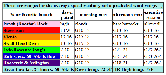
Dawn Patrol wind wasn’t doing much: 5-10mph everywhere except Viento-Hatch. That zone was reading 13-16mph on the iWind/iKite sensors to start the day. By mid-morning, we should see 15-18mph from Viento to Doug’s with 11-14mph at Stevenson (cloudy) and Avery. That, if the models are correct, is the max we’ll see west of Lyle today. Thanks to desert heat, models nudge the wind up to 21-24mph from Lyle to Rufus after 2pm and from Lyle to Arlington after 5pm. We could potentially see 23-26mph, but there’s a complications: those same models also indicate surface-based instability and the potential for thunderstorms (or plain old showers) west of Celilo this afternoon as a low moves into Idaho/eastern WA; if those materialize, all bets are off on the wind anywhere in the Gorge. River flow over the last 24 hours was 60-76kcfs, river temp is 72.5F (potentially lethal to spawning salmon), and high temp forecast is 77F for Hood River and 83F for Rufus.
RIVER FLOW FOR SITES BETWEEN AVERY (EAST OF THE DALLES) AND RUFUS: CLICK HERE FOR JOHN DAY DAM FLOW.
RIVER FLOW FOR SITES BETWEEN STEVENSON AND DOUG’S BEACH (WEST OF THE DALLES): CLICK HERE FOR THE DALLES DAM FLOW

tomorrow’s gorge wind forecast
That low lingers in the desert on Wednesday, and marine clouds once again make an appearance. Models have dawn patrol at 21-24mph from Viento to Mosier with 11-14mph from Lyle to Doug’s and 19-23mph from Maryhill to Boardman. The wind east of The Dalles backs off mid-morning. Viento to Doug’s (maybe Rufus) holds at 21-24mph. Stevenson, buried in marine clouds, probably stays at 13-16mph for the morning. Afternoon wind looks like 19-22mph from Stevenson to Hood River with 22-25mph from Lyle to Rufus and 17-20mph at Arlington. High temp: 75F for Hood River and 82F for Rufus. Do expect the wind to be extra-gusty; surface-based instability will still be present.
extended Gorge wind forecast
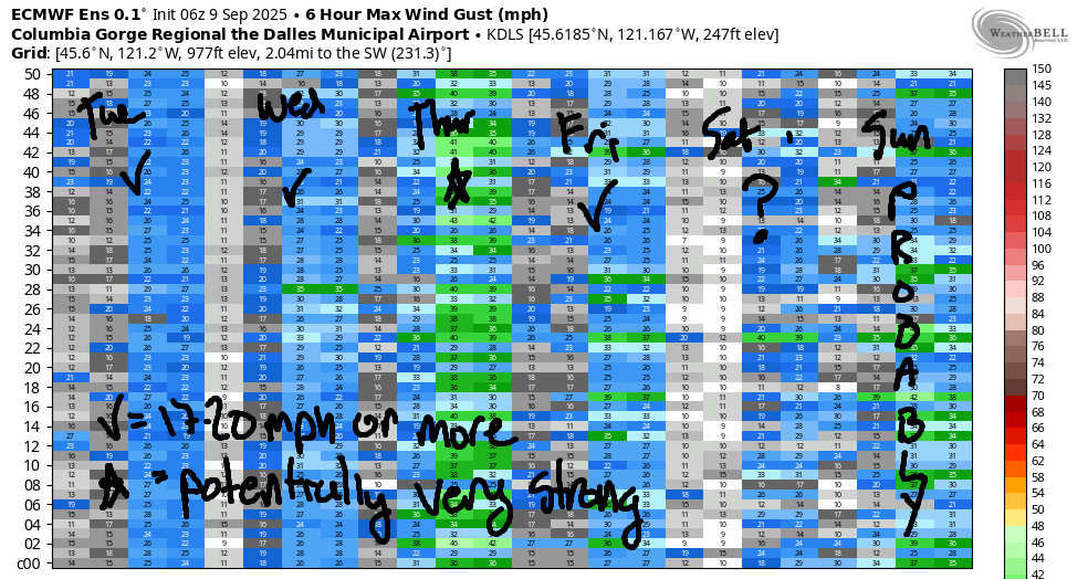
On Thursday, a low moves into Idaho, marine clouds persist for most of the day, and the atmosphere stabilizes. These are all good things! While there’s still a fair bit of uncertainty in the euro ensembles, a decent day on the river is nearly certain. The GFS deterministic gives us 27-30mph+ at the Hatch. The Euro, which focuses on areas east of The Dalles, has 26-29mph out there (which is, remember, not equivalent to 26-29mph at the Hatch – it’s more like 20-23mph). Anyway… there’s some disagreement between the Euro and GFS on the details, but it does seem like a good setup, and I think you can pencil it in as a good day.
Inland ridging (heat, stable weather) builds on Friday. But we’ll still have marine clouds, and we should have decent wind – low 20s, at least. Saturday, thanks to that ridging, looks a bit lighter. Once we get to Sunday, forecasts are all over the map; it does look like we’ll see some sort of temp drop and associated cooldown wind, but there’s still 11 degrees of spread in the forecast high for Sunday. Uncertainty continues into next week, when most days have around a 10 degree spread in the forecast highs. So, we’ll leave it there for now. Have a great day on the Nch’i Wana!
Was that helpful? I knew it was! Guess what? All of this crucial work – from your personal wind and snow reports to the invaluable TATAS updates – is made possible by my relentless efforts. Maintaining this labor of love isn’t easy. Each daily forecast takes hours. Website hosting, weather model access, and back-end admin work takes time and money. That’s where you come in.
YOUR CONTRIBUTION MAKES A DIFFERENCE
- SUPPORT ACCURATE, HYPER-LOCAL WEATHER FORECASTING
- ENABLE ACCESS FOR ALL, EVEN THOSE WITH LESS MEANS
- SUPPORT A COOL HUMAN WHO WORKS HARD SO YOU CAN PLAY
Take a moment to click one of the buttons below. Donate $19.99 or more (how much does this forecast enhance your life?) and get the email in your inbox. Whether it’s a renewing subscription (auto-renew) or a one-time donation, every contribution makes a real difference. Help me keep this labor of love alive, so we can all continue playing, commuting, and living in the Gorge with peace of mind and the best weather forecasts possible. Thank you!


Hood River, Oregon 97031


JONES BEACH, SAUVIE ISLAND, & COAST FORECAST
Wind northerly unless otherwise indicated. For coast, it’s North/Central/South with the “central” at approximately Florence. Swell forecast from NWS for central coast. Jones: westerly unless otherwise stated. Sauvie Island: northerly unless otherwise stated. Coast Tuesday: NW5-10/NW10-15/N15, NW swell 2′ at 13 seconds. Wednesday: NW 5-10/N5-10/N20-25, NW 4′ @ 12. Thursday: NW5-10/NW5-10/N20-25, SW 2′ @ 15. Jones Tuesday: 17-20. Wednesday: 13-16. Thursday: 14-17. Sauvie Island Tuesday: 10-13 > 5pm. Wednesday: 7-10. Thursday: 10-13.
BARE BONES HOOD RIVER WEATHER FORECAST
Clouds this morning and partly high overcast later with a chance of showers. Temps start in the low 60s and rise to the upper 70s. Moderate westerlies. 16% chance of rainbows. Wednesday will be cloudy then mostly clear. Temps start in the mid 50s and rise to the mid 70s. Moderate to moderately strong westerlies. No rainbows. Thursday will be cloudy then partly cloudy. Temps start in the upper 50s and rise to the low 70s. Strong westerlies. No rainbows.
TEMIRA’S AWESOME TRAVEL ADVISORY SERVICE – TUESDAY
HYPERLOCAL WEATHER FORECAST FOR THE COLUMBIA GORGE
THE DALLES, HOOD RIVER, WHITE SALMON, TROUT LAKE, STEVENSON, CASCADE LOCKS, PARKDALE, ODELL, HUSUM, BZ, MILL A, WILLARD, GOLDENDALE, RUFUS, ARLINGTON, boardman
Good morning, neighbors! It rained at my house (briefly) last night, and hopefully it rained at yours. Ma Nature is teasing us – just a little bit of rain here and there. While we have a shot at instability-based showers today and again on Wednesday, widespread rain isn’t in the cards in the next couple of weeks. Yet. Maybe things will change?
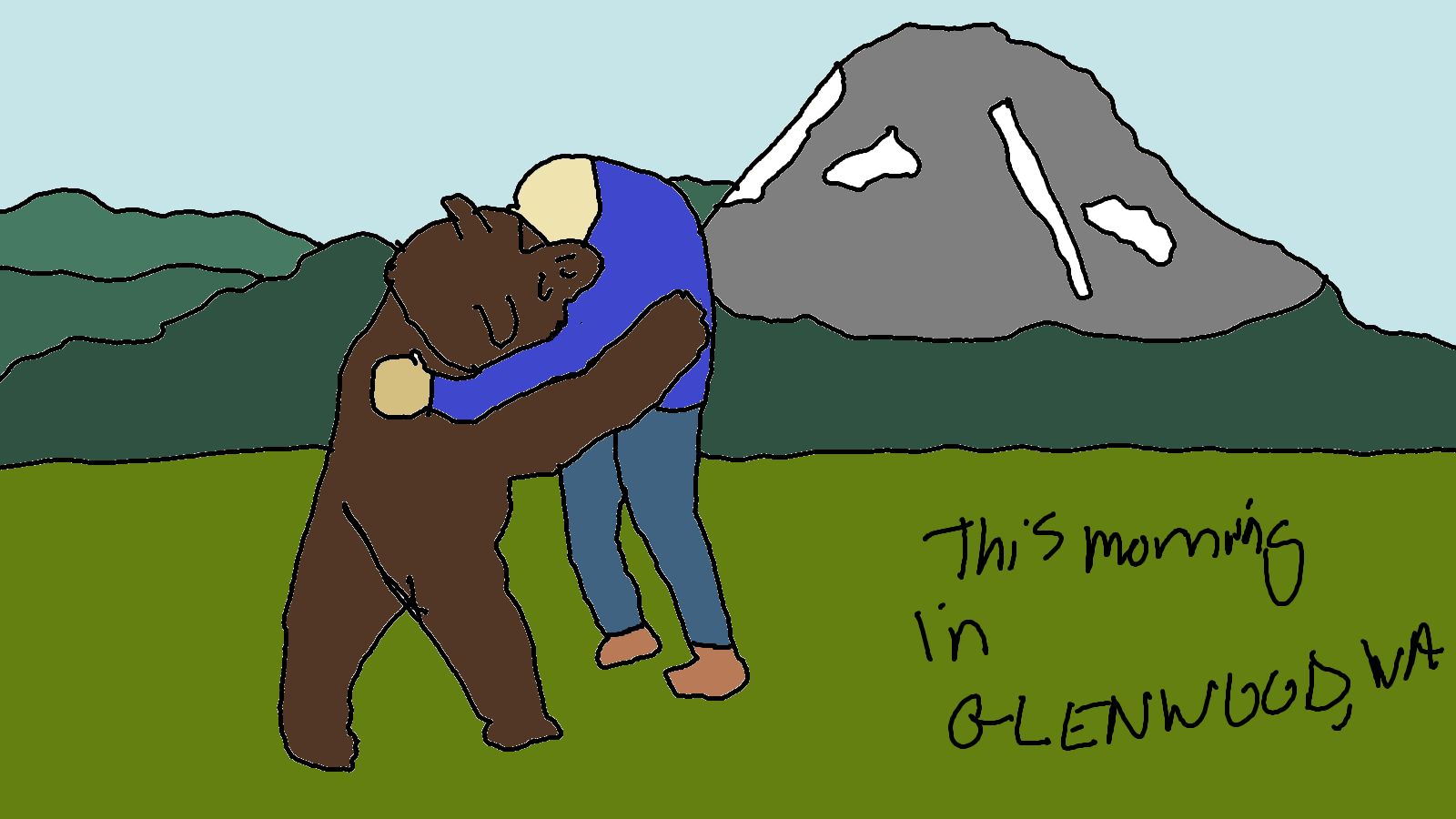
Glenwood this morning
Looking at Tuesday morning, we’re starting with low clouds to the west and a mix of mid and high clouds to the east. Someone somewhere probably had a very colorful sunrise! Up in Glenwood, the sunrise wasn’t all that colorful. That has nothing to do with the temp this morning: 58 degrees, VERY WARM FOR GLENWOOD. Everyone in Glenwood is stocking up on beer and root beer this morning – apparently it’s “International Buy A Priest A Beer Day”. You don’t have to actually buy beer for a priest – any form of generosity and appreciation is the intent of the holiday. It’s also National Teddy Bear Day, which is celebrated in Glenwood by people hugging ACTUAL bears.
Unless you live in Glenwood, you aren’t tough enough to hug bears. Stick with giving bear hugs instead. I’m sending each of you a bear hug right now!
Today’s Gorge weather forecast
Today’s weather: bears will be happy – they like it cool. After yet another annoyingly warm morning (65 degrees in Hood River, 55F in Parkdale, 66F The Dalles), we’ll have a day. Just a day. Temps rise to 77F (west), 83F (The Dalles) and 84F (The Desert). Thanks to abundant available moisture (MUGGY) and surface heating, we have a shot at thunderstorms/rain, especially west of Celilo Village, this afternoon. Thanks to all that, we’ll stick with partly cloudy sky today making for a decent day to be working outside, other than the damned humidity. Wind: 15mph west of Lyle and 20-25mph from Lyle to Arlington, strongest this evening.
Wednesday’s Gorge weather forecast
Overnight, rain is possible east of The Dalles as a wave swings around a low and potentially triggers instability. Wednesday starts with low clouds to the west and partly cloudy sky to the east. It finishes mostly clear. Early wind will disrupt some fishing spots: 20-25mph from Viento to Mosier, 10-15mph from Lyle to Murdoch, and 15-20mph from Avery to Boardman. Afternoon wind will be 20mph from Stevenson to Hood River with 20-25mph from Lyle to Rufus and 15-020mph near Arlington. Other than the potential for early morning rain in the eastern Gorge, the day looks dry. But muggy: dewpoint 50-55 degrees.
Extended Gorge weather forecast
Stable weather settles in for Thursday, but it’ll STILL BE MUGGY: 50-55F dewpoint. Low clouds stick around all day west of Hood River: to the east: partly cloudy then mostly clear. Temps max out in the low 70s (west) and upper 70s (The Dalles and areas to the east). Expect very strong wind west of Mosier early and all the way to Avery, maybe Rufus, in the afternoon. No rain is forecast. That means no rainbows. Friday looks dry and sunny. Saturday probably does too – Saturday actually looks like the warmest of the bunch. Beyond Saturday (Sunday and beyond, for those of you who, like me, can’t track days), uncertainty rises. There’s a chance of rain Sunday or Monday, but uncertainty is super high: many ensembles members have zero rain, and some have up to half an inch for the Cascades. Let’s vote for half an inch of rain for all of us even though it’s unlikely to happen. I’ll be gone again this weekend for a few days and won’t have time to TATAS, but after this, I’ll be around through December. You know, December. When we’ll have some REAL WEATHER to talk about. Safe travels. -TATAS
HEY! DON’T STOP READING! Is this community-focused forecast helpful to you? It sure is! It takes me a couple hours a day to write. Please join your friends and neighbors in contributing to keep it going. Venmo: @thegorgeismygym PayPal: twomirrors@gmail.com USPS: Temira / PO Box 841 / Hood River, Oregon 97031 You can test out the forecast subscription for a few days for free by signing up below. Easy! Do it!
MT HOOD SNOW FORECAST

CURRENTLY ON VACATION. WILL RETURN SOMETIME BEFORE THE START OF SKI SEASON AT MEADOWS, TIMBERLINE AND SKIBOWL. SAME GOES FOR THE NORDIC SKIING SEASON AT MEADOWS AND TEACUP!
