

GORGE WIND FORECAST
If you’re still seeing yesterday’s and it’s after 9am, try opening this in an incognito window
today’s gorge wind forecast
Hi friends! I’m back from Cloud Mountain and ready to type a lot! An interesting fall week is on tap in the Gorge wind forecast: easterlies today and westerlies through the rest of the week as the weather turns increasingly active. It’s probably worth noting that for whatever reason, model accuracy declines this time of year. I’ll do my best, but forecasts are only as good as the math of model accuracy + gut instinct, and when one of those plummets, the total inevitably goes down!
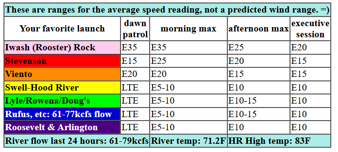
Tuesday’s a relatively easy forecast; east wind days almost always are. We started with a PDX-DLS gradient of 0.18, plenty for solid east wind. As always, get it early. The day starts with 35mph at Iwash (Rooster) Rock. That’s your earliest chance. Stevenson builds to 25-30mph a couple hours later, and Viento joins at 20-25mph. Strong wind holds until noonish and then starts dropping. Iwash/Rooster finishes the day at 20mph, Stevenson at 15mph, and Viento at 10-15mph. Easterlies pick up to 10mph in Hood River in the afternoon and 10-15mph east of Hood River out into the desert. High temp: 83F, low humidity, and full-on sunshine.
RIVER FLOW FOR SITES BETWEEN AVERY (EAST OF THE DALLES) AND RUFUS: CLICK HERE FOR JOHN DAY DAM FLOW.
RIVER FLOW FOR SITES BETWEEN STEVENSON AND DOUG’S BEACH (WEST OF THE DALLES): CLICK HERE FOR THE DALLES DAM FLOW

tomorrow’s gorge wind forecast
Wednesday sees the heat low/ridge shift east, a trough approach the coast, and a weak front move inland. In other words: cool air on the west side and warmer air in the desert. We like that! After a 10-13mph start (the desert starts cold too thanks to excellent radiational cooling), westerlies build. By late morning, we’ll have 17-20mph from Viento to the Hatch. Westerlies keep building into the afternoon, eventually topping out at 23-26mph from Stevenson to Doug’s with 13-16mph at Avery. It’s possible the wind won’t even make it as far east as the Rowena stretch; stay focused on the Corridor. High temp: 84F.
extended Gorge wind forecast
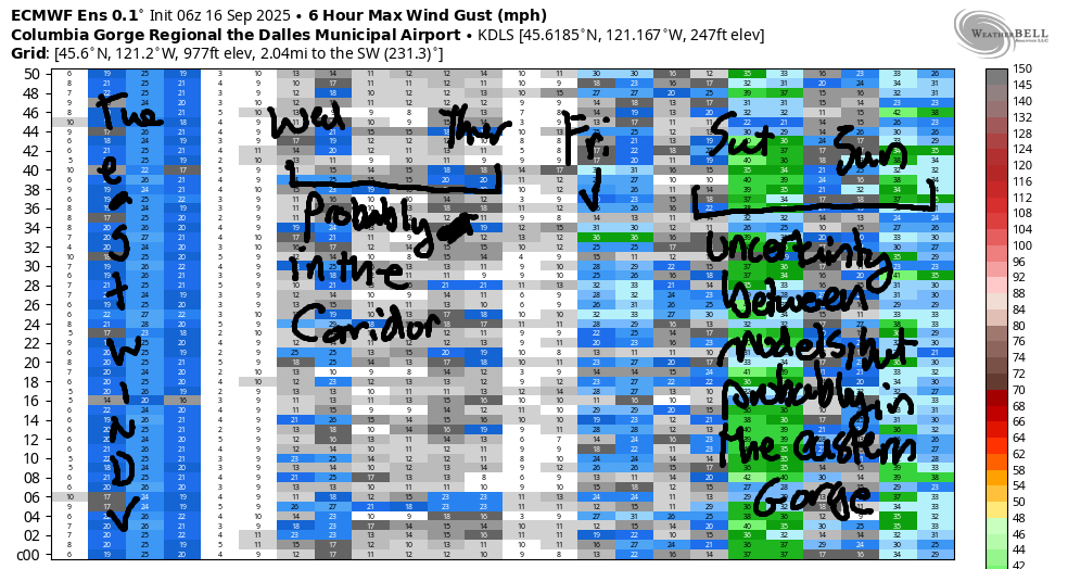
Models are all over the place on Thursday. What does seem clear is that westerlies, should they show up, will be focused near Hood River; the Euro ensemble (data point: The Dalles) is pessimistic. GFS deterministic (a more nuanced look): mid 20s. Why don’t we wait until tomorrow to pencil anything in, okay? High temp: 81F with a marine layer of some sort likely to the west of Hood River, which is a good sign.
Looking at Friday, the GFS continues its optimism, and the ECMWF is more on board. If this pans out, it’s another Corridor day in the low to mid 20s. Looking to the weekend, more active weather is forecast. There’s even some potential for rain on Saturday. That said, the desert looks warm, and the west side looks cool; Saturday is likely to be a windier day than Sunday, but both have at least some potential east of Hood River. Okay. That’s enough days to contemplate for now. Enjoy the easterlies! See you on the Nch’i Wana!
Was that helpful? I knew it was! Guess what? All of this crucial work – from your personal wind and snow reports to the invaluable TATAS updates – is made possible by my relentless efforts. Maintaining this labor of love isn’t easy. Each daily forecast takes hours. Website hosting, weather model access, and back-end admin work takes time and money. That’s where you come in.
YOUR CONTRIBUTION MAKES A DIFFERENCE
- SUPPORT ACCURATE, HYPER-LOCAL WEATHER FORECASTING
- ENABLE ACCESS FOR ALL, EVEN THOSE WITH LESS MEANS
- SUPPORT A COOL HUMAN WHO WORKS HARD SO YOU CAN PLAY
Take a moment to click one of the buttons below. Donate $19.99 or more (how much does this forecast enhance your life?) and get the email in your inbox. Whether it’s a renewing subscription (auto-renew) or a one-time donation, every contribution makes a real difference. Help me keep this labor of love alive, so we can all continue playing, commuting, and living in the Gorge with peace of mind and the best weather forecasts possible. Thank you!


Hood River, Oregon 97031


JONES BEACH, SAUVIE ISLAND, & COAST FORECAST
Wind northerly unless otherwise indicated. For coast, it’s North/Central/South with the “central” at approximately Florence. Swell forecast from NWS for central coast. Jones: westerly unless otherwise stated. Sauvie Island: northerly unless otherwise stated. Coast Tuesday: E10-15/SW10/LTV, NW swell 5′ @ 12 seconds. Wednesday: N15/15/30-35, W 5′ @ 10. Thursday: 20/20-25/35, NW 9 ‘ @ 11. Jones Tuesday: LTV. Wednesday: 17-20. Thursday: 17-20. Sauvie Island Tuesday: E10. Wednesday: N10-13. Thursday: N12-15.
BARE BONES HOOD RIVER WEATHER FORECAST
Clear sky today. Temps start near 50 and rise to the low 80s. Light to moderate easterlies. No rainbows. Wednesday will be clear with a few high clouds late. Temps start in the low 50s and rise to the mid 80s. Light west wind early. Moderately strong later. No rainbows. Thursday will be cloudy then clear. Temps start in the mid 50s and rise to the low 80s. Moderately strong westerlies. No rainbows.
TEMIRA’S AWESOME TRAVEL ADVISORY SERVICE
HYPERLOCAL WEATHER FORECAST FOR THE COLUMBIA GORGE
THE DALLES, HOOD RIVER, WHITE SALMON, TROUT LAKE, STEVENSON, CASCADE LOCKS, PARKDALE, ODELL, HUSUM, BZ, MILL A, WILLARD, GOLDENDALE, RUFUS, ARLINGTON, boardman
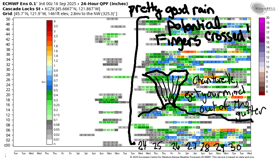
Good morning, neighbors! Today’s about as fall-like as it gets. That’s despite the fact that it’s technically not fall until next Monday. We’ll stick with lots of sunshine for the next four days or so. For the weekend, cooler weather is forecast with a chance of some … rain! Looking deeper into the future, around the 24-26th time period, quite a few of the ensemble members like the idea of a major pattern shift to cooler-and-wetter. Will it be the end of fire season? I dunno, but it’s nice to see all that rain potential popping up in the charts. Fingers crossed!
Glenwood this morning and today’s Gorge weather forecast
Back to this morning… there are a heck of a lot of boats at the mouth of the White Salmon. Wishing all of you luck. Maybe some of you are from Glenwood, where it’s 51 degrees this morning and downright perfect for cooling off the house. It’s also (finally) 45-50ish degrees all over the Gorge, so EVERYONE can take advantage of Ma Nature’s AC. We’ll all rise to the 80s today: 83F to the west, 86F at Grocery Outlet in The Dalles, and 82F out where the watermelons are growing in the desert. We’ll have EAST wind today: 35mph near Iwash (schl*ng) Rock, 25-30mph near Stevenson, and 10-15mph (this afternoon) from Hood River eastward. Up in the foothills, east wind could reach 30mph today, so for the love of the Gorge, don’t start a fire.
Wednesday’s Gorge weather forecast
Another cool start is forecast on Wednesday under clear sky and light wind. As a system approaches the coast, a weak system, one that really won’t do much, west wind returns. This won’t drop the temps: we’ll see mid 80s to the west and east with near 90F at Cousin’s in The Dalles. West wind rises to 20-25mph by late morning or early afternoon between Stevenson and Murdoch. You’ll find lighter wind (and fewer fish) east of The Dalles.
Thursday and Friday Gorge weather forecast
Low clouds push in to the western Gorge, perhaps as far east as Home Valley, on Thursday morning. Everyone else: clear until the afternoon when some high clouds arrive for the east side. After a 50-55F degree start, temps max out in the 80s: low 80s to the west and mid to upper 80s from The Dalles eastward. West wind is likely to rise to 20-25mph between Stevenson and Murdoch. Similar weather is forecast on Friday.
Extended Gorge weather forecast
Models have a shot at rain on Saturday with high temps in the 74 (west) to 84 (east) range. Fishing people: it’s probably going to be windy especially east of Mosier. Slightly cooler weather is forecast Sunday as a cold trough settles in aloft. Beyond Sunday, uncertainty increases in the forecast. That said, most members of the Euro ensemble are hinting at rain starting somewhere in the 24-26 September time period along with much cooler temps. Let’s see how that long-term forecast fares, shall we? Fingers crossed for a soaking and for the end of fire season. Safe travels. -TATAS
HEY! DON’T STOP READING! Is this community-focused forecast helpful to you? It sure is! It takes me a couple hours a day to write. Please join your friends and neighbors in contributing to keep it going. Venmo: @thegorgeismygym PayPal: twomirrors@gmail.com USPS: Temira / PO Box 841 / Hood River, Oregon 97031 You can test out the forecast subscription for a few days for free by signing up below. Easy! Do it!
MT HOOD SNOW FORECAST

CURRENTLY ON VACATION. WILL RETURN SOMETIME BEFORE THE START OF SKI SEASON AT MEADOWS, TIMBERLINE AND SKIBOWL. SAME GOES FOR THE NORDIC SKIING SEASON AT MEADOWS AND TEACUP!
