

GORGE WIND FORECAST
If you’re still seeing yesterday’s and it’s after 9am, try opening this in an incognito window
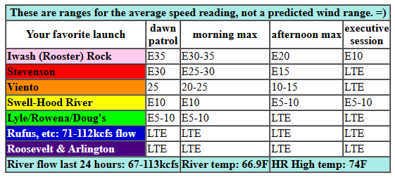
today’s gorge wind forecast
Hi friends! Westerlies are confined to the river this morning, but you’d better get them fast – they’re going to drop quickly. If you miss them, you have a shot at a solid day of westerlies on Wednesday. No much happens on Thursday as lighter easterlies enter the Gorge wind forecast. Friday looks like an active day as a weather system approaches; it’s hard to say if we’ll see enough wind or not. But don’t you worry: Saturday looks like a decent west wind day, if not a big west wind day. Uncertainty increases on Sunday, enough that I can’t really make a forecast for that day’s wind yet.
Looking at Tuesday morning, we have pressures of 29.96/30.11/30.11 for an east gradient of 0.15. Easterlies were right around 30mph at Iwash (Rooster) Rock and Stevenson to start the morning with 20mph at Viento. Get on it right now if you want it. By late morning, wind speeds plummet; models have Iwash and Stevenson at 15mph at 2pm and less than 10mph this evening. River flow over the last 24 hours was 67-113kcfs, river temp is 66.9F, and high temp forecast is 74F and sunny.
RIVER FLOW FOR SITES BETWEEN AVERY (EAST OF THE DALLES) AND RUFUS: CLICK HERE FOR JOHN DAY DAM FLOW.
RIVER FLOW FOR SITES BETWEEN STEVENSON AND DOUG’S BEACH (WEST OF THE DALLES): CLICK HERE FOR THE DALLES DAM FLOW

tomorrow’s gorge wind forecast
West wind returns on Wednesday. A low approaches the coast, and a cold front swings through early. This leaves us buried in low clouds on the west side most of the day with mixed clouds elsewhere. Westerlies start at 20-23mph from Viento to Swell, 11-14mph near Rowena, and 18-22mph east of The Dalles to Rufus. By mid-afternoon, we’ll have 24-27 from Stevenson to Mosier and 27-30mph from Lyle to Arlington. Given the low clouds in the west, building offshore high pressure, and a 10 degree cross-Cascade temp gradient, we could see 29-33mph in the afternoon from Lyle to Arlington. Stevenson-Hood River eventually drop, perhaps mid-afternoon. High temp: 63F in Hood River and 70F out at Rufus.
extended Gorge wind forecast
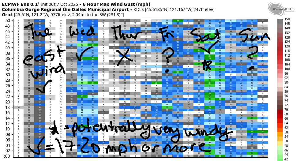
A low pressure system settles in offshore on Thursday and turns the wind easterly. Unless it chooses a different location, in which case that could change. As of this morning, we’re looking at easterlies at (mostly) 10-15mph, but there could be a short period of 15-20mph near Stevenson. High temp: 63F under cloudy sky. A weather system moves through on Friday. Westerlies of some sort are likely, but they’re going to be quite gusty. Best shot at decent wind will be ahead of the incoming rain mid afternoon, but it’ll be a short-lived burst of westerlies. High temp: 65F.
The associated low moves inland on Saturday, strong high pressure builds offshore, rain falls on the west side, and cool, stable air settles in on the west side. Add in elevated W wind at 25-30mph, and we have a shot at a classic fall day. Ensembles are not all-in, but this is definitely the kind of setup where Avery-Arlington is likely to over-perform. Let’s call it 30mph for now and refine as we get closer. Sunday: less wind and rather chilly. That’s it for now. See you on the Nch’i Wana!
Was that helpful? I knew it was! Guess what? All of this crucial work – from your personal wind and snow reports to the invaluable TATAS updates – is made possible by my relentless efforts. Maintaining this labor of love isn’t easy. Each daily forecast takes hours. Website hosting, weather model access, and back-end admin work takes time and money. That’s where you come in.
YOUR CONTRIBUTION MAKES A DIFFERENCE
- SUPPORT ACCURATE, HYPER-LOCAL WEATHER FORECASTING
- ENABLE ACCESS FOR ALL, EVEN THOSE WITH LESS MEANS
- SUPPORT A COOL HUMAN WHO WORKS HARD SO YOU CAN PLAY
Take a moment to click one of the buttons below. Donate $19.99 or more (how much does this forecast enhance your life?) and get the email in your inbox. Whether it’s a renewing subscription (auto-renew) or a one-time donation, every contribution makes a real difference. Help me keep this labor of love alive, so we can all continue playing, commuting, and living in the Gorge with peace of mind and the best weather forecasts possible. Thank you!


Hood River, Oregon 97031


JONES BEACH, SAUVIE ISLAND, & COAST FORECAST
Wind northerly unless otherwise indicated. For coast, it’s North/Central/South with the “central” at approximately Florence. Swell forecast from NWS for central coast. Jones: westerly unless otherwise stated. Sauvie Island: northerly unless otherwise stated. Coast Tuesday: 20/15/LTW, W swell 3′ @ 13 seconds. Wednesday: LTW/LTW/N15, NW 6′ @ 10. Thursday: LTE/S10/S10, NW 6′ @ 11. Jones Tuesday: 16-19. Wednesday: LTW. Thursday: LTE. Sauvie Island Tuesday-Thursday: LTV.
BARE BONES HOOD RIVER WEATHER FORECAST
Mostly clear Tuesday. Temps start in the low 40s and rise to the mid 70s. Light easterlies. No rainbows. Wednesday will be partly to mostly cloudy. Temps start in the mid 40s and rise to the low 60s. Moderately strong westerlies. No rainbows. Thursday will be mostly cloudy. Temps start in the mid 40s and rise to the low 60s. Light easterlies. No rainbows.
TEMIRA’S AWESOME TRAVEL ADVISORY SERVICE
HYPERLOCAL WEATHER FORECAST FOR THE COLUMBIA GORGE
THE DALLES, HOOD RIVER, WHITE SALMON, TROUT LAKE, STEVENSON, CASCADE LOCKS, PARKDALE, ODELL, HUSUM, BZ, MILL A, WILLARD, GOLDENDALE, RUFUS, ARLINGTON, boardman
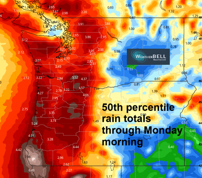
Good morning, neighbors! Another glorious fall day is on tap. It’s just so dang nice working in the garden right now – fall 70 degrees with the lower sun angle is way cooler than summer 70 degrees with the sun right overhead. Gardeners: now is a perfect time to get in those cover crops – it’s warm enough to germinate them, and we have rain coming in this weekend to nourish them. But not too much rain. No, not enough to destroy Harvest Fest, and also not enough rain to soak the naked bike ride protesters in Portland on Sunday. Ride starts at 2:30pm, location TBD. Forecast is for cloudy sky, dry weather, and a high temp somewhere in the 53-63 degree range.
Glenwood this morning
Seeing as how that’s many days out, let’s come back to the present and check in with Glenwood: 28 degrees there this morning. Elsewhere: Centerville was 32F. Parkdale area: 33-40F. With he exception of Glenwood, that should be it for frost chances for a bit – we’re headed into a cloudier weather pattern starting tomorrow. Next chance for frost: Sunday onward as 850mb temps drop to 0C. 0C! That’s good enough for a snow level of 4000′ or less!
Today’s Gorge weather forecast
But not today. Nope. It’s Tuesday, and it’ll be sunny all day. Temps rise to 74-77F. Wind: 30mph this morning out of the east near Iwash (cock) Rock and Stevenson with 20mph near Home Valley and Viento. Afternoon: less than 15mph east wind in those windy spots and light wind elsewhere in the lowlands. Up in the hills: S 10-15mph this morning and SW 10-15mph later. Clouds push in overnight.
Wednesday’s Gorge weather forecast
Those clouds continue to build into the day on Wednesday, and they spread eastward. A few raindrops aren’t out of the question in the far western Gorge, but they’re also not all that likely. More likely: cooler highs (63F west, 68F The Dalles, 73F desert) and stronger wind. Morning westerlies will be 20-25mph from Stevenson to Rufus with 15-20mph near Lyle. Afternoon: 25-35mph all the way from Stevenson to Arlington, strongest east of Mosier. Great for Boardheads. Shitty for fishing. Up in the mountain Wednesday, the freezing level falls to around 4500′.
Thursday’s Gorge weather forecast
Thursday’s weather responds to an offshore low; we’ll have lots of clouds. About 40% of the Euro ensemble gives us some rain on Thursday in the form of wraparound moisture from the offshore low. Fingers crossed! If it’s going to be cloudy and cool, it might as well rain! Temps max out around 63F (Hood River), 67F (The Dalles), and 69F (desert, where everyone is still eating ice cream for dessert because it’s still warm enough. They’ll switch to rice pudding soon.) Wind on Thursday will (probably) be widespread, out of the east, and 10-15mph.
Extended Gorge weather forecast
Cool, sprinkly weather is forecast on Friday: 65-70F and just a few scattered sprinkles, probably, at lest until 5pm when real rain is possible. Rainy weather is forecast for the west side (“west side” definition TBD depending on what we see in the models in the next couple of days) on Saturday. Also in the forecast: potentially very strong west wind. Highs on Saturday fall below 60F west of Mosier and only rise to the mid 60s in the desert. Sunday: cool, cloudy, and probably not too windy.
Up in the mountains, the snow level falls to 5000′ on Friday afternoon and stays that low or lower through the weekend. It’s not clear yet how much snow the mountains will pick up, but that amount is definitely greater than zero. Given the 25-30mph west wind aloft on Saturday, it’s possible the totals on Bennett Pass will be enough to make for wintry conditions despite the warm road temps. We’ll watch this closely. Winter is coming… Safe travels. -TATAS
HEY! DON’T STOP READING! Is this community-focused forecast helpful to you? It sure is! It takes me a couple hours a day to write. Please join your friends and neighbors in contributing to keep it going. Venmo: @thegorgeismygym PayPal: twomirrors@gmail.com USPS: Temira / PO Box 841 / Hood River, Oregon 97031 You can test out the forecast subscription for a few days for free by signing up below. Easy! Do it!
MT HOOD SNOW FORECAST

CURRENTLY ON VACATION. WILL RETURN SOMETIME BEFORE THE START OF SKI SEASON AT MEADOWS, TIMBERLINE AND SKIBOWL. SAME GOES FOR THE NORDIC SKIING SEASON AT MEADOWS AND TEACUP!
