

GORGE WIND FORECAST – IF YOU’RE SEEING YESTERDAY’S, TRY OPENING THIS IN A PRIVATE BROWSER WINDOW
today’s gorge wind forecast
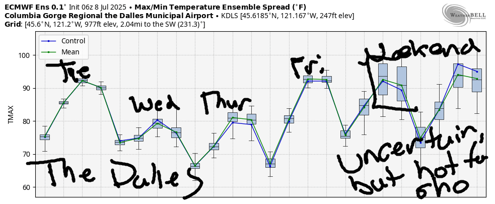
Hi friends! I’m looking out my window this morning, and there are already whitecaps on the river. We’ll have westerlies today, Wednesday, and Thursday. That’s followed by a possible rest day on Friday as heat re-establishes itself. Friday’s rest day is (probably – lots of uncertainty in the Gorge wind forecast ensembles) followed by westerlies for the weekend as the desert really heats up and the west side holds around 90 degrees.
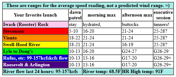
Looking at Tuesday morning, we see pressures of 29.98/29.91/29.89 for gradients of 0.07 (PDX-DLS) and 0.02 (DLS-PSC). The Gorge and the metro area both started the day clear. On top of that, we have a couple of weather systems approaching – one from the north and one down south. With all this movement, the wind is likely to be a bit fickle today. By mid-morning, we’ll have 19-22 from Viento to Hood River. Stevenson and Mosier won’t be far behind – they’ll join at 19-22 this morning as well. Models suggest 21-24 from Stevenson to Mosier late morning. Up next: the midday lull at the Hatch – westerlies likely drop to 16-19 there for a bit.
We then start to see more influence from these approaching systems; if the timing is right, cooler air will push into the metro area this evening and aid our temp gradient. If that works out, we’ll have gusty 22-25 from Stevenson to Mosier with the Hatch at gusty 18-21. Between Lyle and Avery, westerlies rise to gusty 24-27 by 5pm. If that cooler air can make it to the metro area before sunset, the Executive Session (after 5pm) will shine with gusty 26-29 from Mosier to Arlington. Not only that, but the cool air on the west side could stabilize things enough for 25-28 from Stevenson to Swell. Fingers crossed! River flow over the last 24 hours was 95-157kcfs, river temp is 68.5F, and high temp forecast is 91F for Hood River and 97F for Arlington.
RIVER FLOW FOR SITES BETWEEN AVERY (EAST OF THE DALLES) AND RUFUS: CLICK HERE FOR JOHN DAY DAM FLOW.
RIVER FLOW FOR SITES BETWEEN STEVENSON AND DOUG’S BEACH (WEST OF THE DALLES): CLICK HERE FOR THE DALLES DAM FLOW

tomorrow’s gorge wind forecast
Deep marine clouds stack up against the Cascades on Wednesday morning. They may push past Hood River. We start with gusty 17-21 between Stevenson and Doug’s with 25-28 from Avery to Arlington. Westerlies quickly build to 28-32+ from Lyle to Arlington late morning. Threemile joins at 28-32 in the afternoon, and Boardman rises to 25-28. Models suggest two competing outcomes: lingering clouds west of Mosier and increasing wind west of Mosier. If the clouds burn back enough, we’ll see Stevenson-Mosier rise to gusty 22-27 in the afternoon. If not, the wind will be lighter but still very up-and-down. High temp: 79F for Hood River and 86F for Arlington.
extended Gorge wind forecast
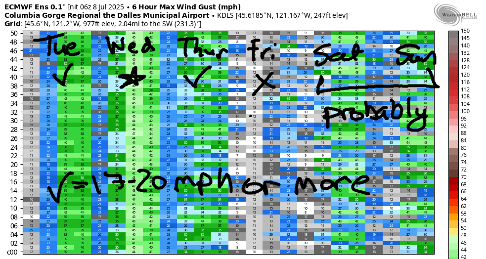
Some marine clouds are likely on the west side on Thursday. In addition, we’ll have building offshore high pressure. At a minimum, we should see 19-22 from Stevenson to Mosier in the afternoon with 13-16 from Lyle to Doug’s. East of there: light wind. If the marine clouds over-perform, so will the wind. Fingers crossed! As of this morning, Friday’s looking like a light wind day for the Gorge. Better options: Jones Beach, Sauvie Island, and the coast, which will be windy all the way from Oceanside to Pistol River.
Looking at the weekend, we see a ton of range in the possible high temps and thus the wind speed. It does look like the temp gradient will be onshore, which would give us west wind. This morning’s ensembles look better than yesterday’s in terms of our weekend wind. As of now, I’d say pencil it in, because 90% of the ensembles are calling for 17-20+, and many have stronger wind in the cards. All right. That seems like enough for today. Have a great day on the river!
Was that helpful? I knew it was! Guess what? All of this crucial work – from your personal wind and snow reports to the invaluable TATAS updates – is made possible by my relentless efforts. Maintaining this labor of love isn’t easy. Each daily forecast takes hours. Website hosting, weather model access, and back-end admin work takes time and money. That’s where you come in.
YOUR CONTRIBUTION MAKES A DIFFERENCE
- SUPPORT ACCURATE, HYPER-LOCAL WEATHER FORECASTING
- ENABLE ACCESS FOR ALL, EVEN THOSE WITH LESS MEANS
- SUPPORT A COOL HUMAN WHO WORKS HARD SO YOU CAN PLAY
Take a moment to click one of the buttons below. Donate $19.99 or more (how much does this forecast enhance your life?) and get the email in your inbox. Whether it’s a renewing subscription (auto-renew) or a one-time donation, every contribution makes a real difference. Help me keep this labor of love alive, so we can all continue playing, commuting, and living in the Gorge with peace of mind and the best weather forecasts possible. Thank you!


Hood River, Oregon 97031


JONES BEACH, SAUVIE ISLAND, & COAST FORECAST
Wind northerly unless otherwise indicated. For coast, it’s North/Central/South with the “central” at approximately Florence. Swell forecast from NWS for central coast. Jones: westerly unless otherwise stated. Sauvie Island: northerly unless otherwise stated. Coast Tuesday: LTNW/LTNW/LTS, N swell 4′ at 7 seconds. Wednesday: LTW/LTW/N20, NW 3′ @ 8. Thursday: N15/20/30-35, W 4′ @ 8. Jones Tuesday: 21-24. Wednesday: LTW. Thursday: 14-17. Sauvie Island Tuesday: 13-16 > 5pm. Wednesday: 9-11. Thursday: 10-13.
BARE BONES HOOD RIVER WEATHER FORECAST
Clear sky all day. Temp start in the upper 60s and rise to the lo w90s. Moderately strong westerlies. No rainbows. Wednesday will be partly to mostly cloudy. Temps start in the low 60s and rise to the upper 70s. Moderately strong westerlies. No rainbows. Thursday will be partly cloudy then clear. Temps start near 60 and rise to 80. Moderate westerlies. No rainbows.
TEMIRA’S AWESOME TRAVEL ADVISORY SERVICE – TUESDAY 7/8
HYPERLOCAL WEATHER FORECAST FOR THE COLUMBIA GORGE
THE DALLES, HOOD RIVER, WHITE SALMON, TROUT LAKE, STEVENSON, CASCADE LOCKS, PARKDALE, ODELL, HUSUM, BZ, MILL A, WILLARD, GOLDENDALE, RUFUS, ARLINGTON, boardman
Good morning, neighbors. I don’t know about you, but I’ve got my eyes on some nice cool weather: For this week, that’s Wednesday and Thursday, when high temps will drop to 80 or so on the west side. After that: more of this 90+ degree weather, most likely, although there’s lots of range in the possibilities.
GLENWOOD THIS MORNING
Know who didn’t start the day hot? The people of Glenwood. This morning’s low was 49 degrees. Everyone tossed on an extra layer and went outside to knit brown mittens on the porch. Every fall in Glenwood on October 32nd, there’s a Brown Mitten sale. Proceeds are split 33-33-33 between pre-split firewood, split pea soup, and brown yarn for the next year’s sale. The last 1% goes to buy thermometers for everyone in town so people can know just how cold it is there on winter mornings.
TODAY’S GORGE WEATHER FORECAST
The rest of us started this morning between 53 degrees (northern areas of Parkdale) and 73 degrees (Mosier Market). We’re all headed for 90+ today: 91 (west), 97 (Dallesport), and 103 (the watermelons of Hermiston). West wind rises to 20-25mph between Stevenson and Mosier this morning with 25-30mph from Mosier to the the Arlington (scalene) Triangle this afternoon.
WEDNESDAY’S GORGE WEATHER FORECAST
Those of you west of Lyle-ish will wake up to something different on Wednesday morning: clouds. No, it’s not going to rain for most of us. A tiny bit of drizzle is possible west of Cascade Locks and on the uninhabited west slopes of Mt. Hood during the day, where the bears are pooping in the woods and trees are falling without anyone to hear them. But that’s it for moisture on Wednesday. That’s sad, because we need a ton of rain at Wyeth right now – someone started a fire there yesterday. Morning temps will be in the low 60s, mostly. Wednesday’s temps max out in the upper 70s (west), mid 80s (The Dalles), and mid 90s (out by the watermelon fields). We’ll have increased moisture too: dewpoints rise to the low-mid 50s, which leaves us all sweaty and sticky. Thankfully, the wind will evaporate the sweat: 20-25mph west of Lyle and 25-35mph from Lyle to Threemile Canyon with 25-30mph near Boardman. Up in the hills: 15-25mph. NWS has posted a Fire Weather Watch from Viento eastward (on the WA side, cuz by a quirk of distracting, that’s Pendleton NWS’ territory). Don’t. Burn. Shit.
EXTENDED GORGE WEATHER FORECAST
Expect another warm morning on Thursday: 60ish degrees. Clouds stack up west of Hood River early, but areas to the east will be clear. By afternoon, sunshine prevails. Temps rise to 80 (west) and upper 80s (east) with west wind at 20mph between Stevenson and Mosier with 15mph from Lyle to The Dalles.
Looking for a light wind day? Friday’s your day. It’ll be hot: 92-95 degrees and sunny. 90+ degree weather continues through the weekend, when it’ll also be muggy and breezy. Having said that, I’ll also mention that model uncertainty is high for the weekend: there’s about 10 degrees of spread in the temp range starting this weekend and continuing into the extended forecast for the next 10-14 days. There’s also a wide range of how much mugginess will infiltrate the Gorge, your crotch, and your pits. Know what’s not in that forecast? Significant rain. Or even measurable rain. Humph. I suppose it can be dry until cherry harvest is over, but it sure would be nice to get a bunch of rain after that. Safe travels. -TATAS
HEY! DON’T STOP READING! Is this community-focused forecast helpful to you? It sure is! It takes me a couple hours a day to write. Please join your friends and neighbors in contributing to keep it going. Venmo: @thegorgeismygym PayPal: twomirrors@gmail.com USPS: Temira / PO Box 841 / Hood River, Oregon 97031 You can test out the forecast subscription for a few days for free by signing up below. Easy! Do it!
