

GORGE WIND FORECAST
today’s gorge wind forecast
Hi friends! Westerlies continue in some form or another all the way through Saturday, at least. That’s a decent Gorge wind forecast, eh? It will be windy, but the setup isn’t perfectly stable – that’s going to make the wind more up-and-down and less predictable than it was last week. There’s at least some possibility of a rest day on Sunday as a low pressure system settles inland, knocks down the gradients, and destabilizes the atmosphere.
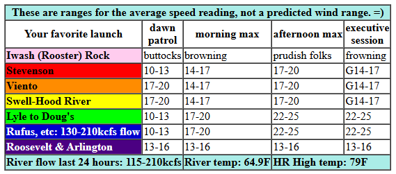
Let’s look at Tuesday’s start: pressures of 30.12/30.04/29.99 and west wind in the 14-17 range most places. We’ll see 17-20 from Viento to Mosier this morning. Models hint at the wind in the Viento-Hood River zone bouncing around between 17-20 and 14-17 today. Stevenson starts in the low teens and then does the same 17-20/14-17 thing. Out east, the wind started at 15-18, but it’s likely to drop to 12-15 late morning before rising to 22-25 from Mosier to Rufus this afternoon. Arlington maxes out at 16-19 this evening. River flow over the last 24 hours was 115-210kcfs, river temp is 64.9F, and high temp forecast is 79F for Hood River.
RIVER FLOW FOR SITES BETWEEN AVERY (EAST OF THE DALLES) AND RUFUS: CLICK HERE FOR JOHN DAY DAM FLOW.
RIVER FLOW FOR SITES BETWEEN STEVENSON AND DOUG’S BEACH (WEST OF THE DALLES): CLICK HERE FOR THE DALLES DAM FLOW

tomorrow’s gorge wind forecast
A cold front slides inland on Wednesday. Deep low clouds stack up against the Cascades and persist all day. The cloud line will determine whether the Corridor (Swell to Hood River) is part of the fun. For the early morning, we’ll have 11-14 from Stevenson to The Dalles and 19-22 from Avery to Arlington. Afternoon wind builds to 28-32 from Lyle to Rufus with 27-30 at Threemile. To the west, the extent of the clouds will determine wind strength and location. Mosier will be right on the edge for gusty 20-24 (if it’s cloudy) or 28-32 (if it’s sunny all day). Models suggest areas west of Mosier will at least partially clear in the afternoon for very gusty 20-25+ between Stevenson and Hood River. After 5pm, the wind starts to fade everywhere. High temp: 73F for Hood River and 79F and sunny for Arlington.
extended Gorge wind forecast
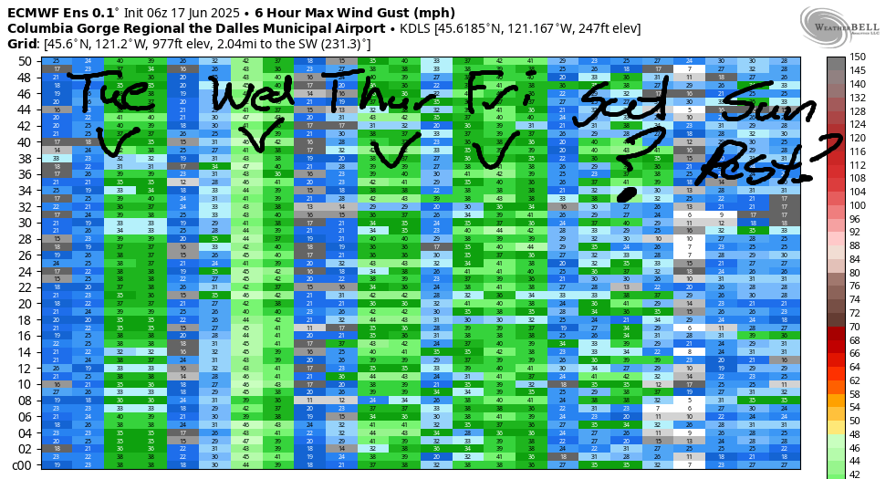
A more stable setup on Thursday sets us up for another windy day. As of this morning, we’re looking at 22-25 for TJ’s Dawn Patrol at the Hatch followed by a mid-morning dip then a late morning resurgence: 24-27 from Stevenson to Mosier and 26-29 from Lyle to Avery and perhaps Rufus. High temp: 75F for Hood River and 79F for Arlington.
We then move into a more active weather pattern for the Friday through Sunday period. Rain is forecast for the west side Friday and Saturday. This shifts the action east. As of this morning, we’re expecting mid to upper 20s east of Hood River Friday and Saturday. Sunday looks less windy, perhaps 15-18, as a low pressure system settles over the Gorge with cool, cloudy weather and a slight chance of thunderstorms. Model hint at lighter wind to start next week – we might even see an actual Ma-Nature-enforced rest day or two! Have a great day today. I’ll see you on the Nch’i Wana!
Was that helpful? I knew it was! Guess what? All of this crucial work – from your personal wind and snow reports to the invaluable TATAS updates – is made possible by my relentless efforts. Maintaining this labor of love isn’t easy. Each daily forecast takes hours. Website hosting, weather model access, and back-end admin work takes time and money. That’s where you come in.
YOUR CONTRIBUTION MAKES A DIFFERENCE
- SUPPORT ACCURATE, HYPER-LOCAL WEATHER FORECASTING
- ENABLE ACCESS FOR ALL, EVEN THOSE WITH LESS MEANS
- SUPPORT A COOL HUMAN WHO WORKS HARD SO YOU CAN PLAY
Take a moment to click one of the buttons below. Donate $19.99 or more (how much does this forecast enhance your life?) and get the email in your inbox. Whether it’s a renewing subscription (auto-renew) or a one-time donation, every contribution makes a real difference. Help me keep this labor of love alive, so we can all continue playing, commuting, and living in the Gorge with peace of mind and the best weather forecasts possible. Thank you!


Hood River, Oregon 97031


JONES BEACH, SAUVIE ISLAND, & COAST FORECAST
Wind northerly unless otherwise indicated. For coast, it’s North/Central/South with the “central” at approximately Florence. Swell forecast from NWS for central coast. Jones: westerly unless otherwise stated. Sauvie Island: northerly unless otherwise stated. Tuesday: LTW/LTW/N10-15, W swell 5′ at 10 seconds. Wednesday: LTNW/NW5-10/N25-30, W 3′ @ 8. Thursday: NW10/NW10-15/N30-35, W 6′ @ 12. Jones Tuesday: 19-22. Wednesday: 9-11. Thursday: 18-21. Sauvie Island Tuesday: 16-19 > 5pm. Wednesday: 16-19 > 5pm. Thursday: 17-20.
BARE BONES HOOD RIVER WEATHER FORECAST
Clear sky today. Temps start in the upper 50s and rise to the upper 70s. Moderate westerlies. No rainbows. Wednesday will be cloudy then partly cloudy. Temps start in the mid 50s and rise to he low 70s. Moderate westerlies early. Moderately strong late. 0.5% chance of rainbows. Thursday will be mostly clear then high cloudy. Temps star tin the upper 40s and rise to the mid 70s. Strong westerlies. No rainbows.
TEMIRA’S AWESOME TRAVEL ADVISORY SERVICE – TUESDAY 6/18
HYPERLOCAL WEATHER FORECAST FOR THE COLUMBIA GORGE
THE DALLES, HOOD RIVER, WHITE SALMON, TROUT LAKE, STEVENSON, CASCADE LOCKS, PARKDALE, ODELL, HUSUM, BZ, MILL A, WILLARD, GOLDENDALE, RUFUS, ARLINGTON, boardman
Good morning, neighbors! Yet another sunny, breezy day is on tap today. Ditto for Wednesday and ditto for Thursday. Starting Friday, a low pressure system starts to impact the Gorge with rain chances sticking around through the weekend. Models have upped the available moisture for the three-day period, and that’s upped the chances of measurable and/or soaking rain. But first…
glenwood’s start today
Glenwood. Goodness. 38 degrees this morning. With 850mb temps forecast to fall to 3C on Saturday morning, y’all better hang on to as many clouds as you can get Friday night or it’s gonna get real chilly.
TODAY’S GORGE WEATHER FORECAST
Down here in the valleys on Tuesday, we’ll have a sunny day. After a 50-something degree start, temps rise to the mid 70s (west), low 80s (The Dalles), and upper 80s (watermelon growing zones to the east). Westerlies will be 15-20mph from Stevenson to Mosier this morning with 10-15mph east of Mosier. Afternoon wind rises to 20-30mph from Mosier to Rufus and sticks with 15-20mph between Stevenson and Hood River. That is all. A weather system moves in tonight and drags clouds as far east as Hood River or maybe Mosier.
TOMORROW’S GORGE WEATHER FORECAST
This system won’t do much on Wednesday for most of us, but areas west of Wyeth should see a little drizzle between 5am and noon or so. East of Mosier: sunshine all day long! I know, you’re bored of sunshine. You’ll get your clouds this weekend. Morning temps will be in the mid 50s, a bit on the warm side thanks to humidity. If you’ve been wanting a break from the sun and have the means to skip out on your responsibilities Wednesday morning, head to Corbett or somewhere around there for cloud cover. By afternoon, the west side will turn partly cloudy. West wind starts at 10-15 west of The Dalles with 20-25 to the east. Afternoon wind will be 20-25mph west of Mosier and 25-35mph between Mosier and Threemile Canyon. High temps range from 70 (west) to 87 (watermelon zones).
THURSDAY’S GORGE WEATHER FORECAST
A brief round of high pressure (the weather kind, not the life kind – we already have enough of the latter) settles in for Thursday. We’ll have a mostly clear start and a mostly high cloudy finish. High clouds in the evening are often accompanied by colorful sunsets. Prepare for this possibility and also for the possibility of connecting with other humans also marveling at the beauty of nature. Temps will be near 50 to start and 75-83 to finish.
EXTENDED GORGE WEATHER FORECAST
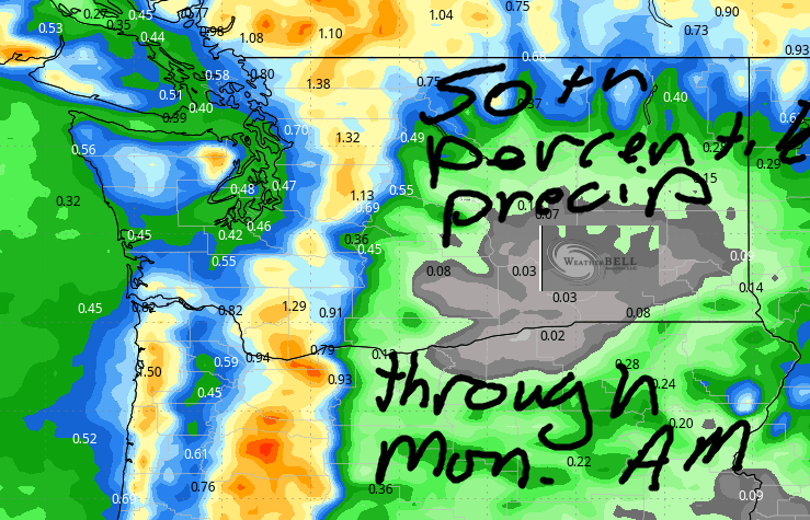
Now, let’s look at this Friday-Sunday rain potential. A low drops inland from the NW on Friday. This drags a front and accompanying rain into the west half of OR/WA. An additional system from the west is forecast on Saturday; that one will have a bit more moisture with it. As the low settles inland on Friday afternoon and persists into Sunday, we’ll have the potential for thunderstorms or instability-driven showers that wrap around the low. This puts all of us at risk for random rain on Saturday and Sunday, especially on Sunday. Weather Friday will be windy and 60-65 degrees. Saturday will be less windy, maybe 15-20mph, with a high of 60ish. Somewhat warmer, but less windy weather is forecast Sunday with a higher chance of those random heavy downpours at all locations between Stevenson and Biggs.
Total rain forecast by the Euro ensembles is 0.5” to 0.85” for the Cascade Crest and areas west of Underwood. The Dalles: 0.05” to 0.2”. East: just random showers that are kinda unpredictable. Hopefully that helps all our cherry farmer friends make spraying decisions. To the rest of you – happy gardening. Do something kind for a random stranger today. Safe travels. -TATAS
HEY! DON’T STOP READING! Is this community-focused forecast helpful to you? It sure is! It takes me a couple hours a day to write. Please join your friends and neighbors in contributing to keep it going. Venmo: @thegorgeismygym PayPal: twomirrors@gmail.com USPS: Temira / PO Box 841 / Hood River, Oregon 97031 You can test out the forecast subscription for a few days for free by signing up below. Easy! Do it!
