

GORGE WIND FORECAST
If you’re still seeing yesterday’s and it’s after 9am, try opening this in an incognito window
today’s gorge wind forecast
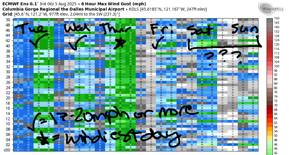
Hi friends! My what a windy day we had yesterday! Nothing so spectacular is in the cards for the next week or so, but Thursday looks like it will have some power to it. Next chance of nuking wind in the Gorge wind forecast is in the middle part of next week when we tumble out of a brief hot spell. Let’s dive in to today’s forecast, shall we?
Today’s overall picture is driven by a frontal system approaching the coast. Generally this makes for gusty wind, and it often makes the wind under-perform the gradients. Pressures at 7am were 30.09/30.01/29.99 for gradients of 0.08 (PDX-DLS) and 0.02 (DLS-PSC). The metro area started the day clear and sunny, so we’ll have no help there. Early westerlies were 15-18mph from Viento to Hood River with 10-13mph everywhere to the east and 5-10mph at Stevenson. We’ll see 15-18mph this morning from Stevenson to Mosier.
Afternoon wind, ahead of the approaching front, rises to gusty 18-21mph from Stevenson to Arlington. Models suggest a mid-afternoon collapse to 16-19mph between Stevenson and Mosier with a rise to gusty 22-26mph from Avery to Arlington. Remember that this forecast predicts to the iWind/iKite sensors; 22-26mph east of The Dalles is approximately equivalent to 17-20mph on the Swell sensor. Strongest wind today is likely to be between Lyle and Doug’s. River flow over the last 24 hours was 84-108kcfs, river temp is 70.9F, and high temp forecast is 80F for Hood River and 87F at Rufus.
RIVER FLOW FOR SITES BETWEEN AVERY (EAST OF THE DALLES) AND RUFUS: CLICK HERE FOR JOHN DAY DAM FLOW.
RIVER FLOW FOR SITES BETWEEN STEVENSON AND DOUG’S BEACH (WEST OF THE DALLES): CLICK HERE FOR THE DALLES DAM FLOW

tomorrow’s gorge wind forecast
In a fun twist, Wednesday starts rainy west of The Dalles. This isn’t quite the cloud line we’re looking for, but it will help the afternoon wind. West of Avery, westerlies are likely to stay under 10mph all day. From Avery to Arlington, the wind starts light. It slowly builds to 21-24mph in the afternoon. High temps: 73F in Hood River and 80F at Rufus.
extended Gorge wind forecast

Clouds linger on the west side on Thursday, and sunshine heats the desert. While the GFS is currently suggesting an eastern Gorge day thanks to long-lasting marine clouds, the actual outcome depends on those clouds. For now, let’s call it 15-20mph from Stevenson to Arlington to start the day. Midday wind rises to 25-28mph between Mosier and Rufus. As the clouds burn back, Stevenson-Hood River climbs to very gusty 23-26mph, and Mosier to Rufus rises to 27-30mph. Arlington: 22-25mph midday and 17-20mph in the afternoon. High temps: 73F in Hood River and 80F at Rufus.
Friday currently looks like 17-20mph centered near Hood River, but there’s a lot of range in the ensemble prediction. Ditto on Saturday. About 50% of the ensemble members shut the wind down on Sunday. The others are more optimistic. Monday doesn’t look promising either unless the cooldown from the weekend heat wave happens Monday. Stronger wind is likely next Tuesday through Thursday (so say the ensembles) as we return to our regularly scheduled cross-Cascade onshore temperature gradient. Hopefully that all helps with your planning. Have a great day on the river!
Was that helpful? I knew it was! Guess what? All of this crucial work – from your personal wind and snow reports to the invaluable TATAS updates – is made possible by my relentless efforts. Maintaining this labor of love isn’t easy. Each daily forecast takes hours. Website hosting, weather model access, and back-end admin work takes time and money. That’s where you come in.
YOUR CONTRIBUTION MAKES A DIFFERENCE
- SUPPORT ACCURATE, HYPER-LOCAL WEATHER FORECASTING
- ENABLE ACCESS FOR ALL, EVEN THOSE WITH LESS MEANS
- SUPPORT A COOL HUMAN WHO WORKS HARD SO YOU CAN PLAY
Take a moment to click one of the buttons below. Donate $19.99 or more (how much does this forecast enhance your life?) and get the email in your inbox. Whether it’s a renewing subscription (auto-renew) or a one-time donation, every contribution makes a real difference. Help me keep this labor of love alive, so we can all continue playing, commuting, and living in the Gorge with peace of mind and the best weather forecasts possible. Thank you!


Hood River, Oregon 97031


JONES BEACH, SAUVIE ISLAND, & COAST FORECAST
Wind northerly unless otherwise indicated. For coast, it’s North/Central/South with the “central” at approximately Florence. Swell forecast from NWS for central coast. Jones: westerly unless otherwise stated. Sauvie Island: northerly unless otherwise stated. Coast Tuesday: W15/LTV/N5-10, SW swell 2′ at 15 & W 2′ @ 14. Wednesday: W5-10/LTV/N10-15, W 6′ @ 11. Thursday: LTNW/N10/N30+, W 5′ @ 11. Jones Tuesday: 11-14. Wednesday: calm. Thursday: LTW. Sauvie Island Tuesday: 7-10. Wednesday: LTV. Thursday: 9-12.
BARE BONES HOOD RIVER WEATHER FORECAST
Mixed clouds this morning and increasing high clouds later. Temps start in the low 60s and rise to 80 or so. Moderate westerlies. No rainbows. Wednesday will be cloudy with RAIN LIKELY early. Temps start in the upper 50s and rise to the low 70s. Light westerlies. 99% chance of rainbows. Thursday will be mostly cloudy early with a few scattered sprinkles possible. Later: partly cloudy. Temps start in the upper 50s and rise to the low 70s. Light westerlies early. Strong later. 4% chance of rainbows.
TEMIRA’S AWESOME TRAVEL ADVISORY SERVICE – TUESDAY 8/5
HYPERLOCAL WEATHER FORECAST FOR THE COLUMBIA GORGE
THE DALLES, HOOD RIVER, WHITE SALMON, TROUT LAKE, STEVENSON, CASCADE LOCKS, PARKDALE, ODELL, HUSUM, BZ, MILL A, WILLARD, GOLDENDALE, RUFUS, ARLINGTON, boardman
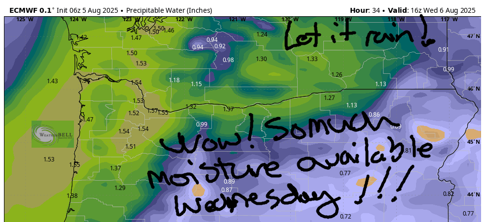
Good morning, neighbors! A beautiful thing has entered the forecast: RAIN! Models jacked up the PWAT (available moisture) to 200% (3.5 sigmas) for Wednesday morning, and a front with a bit of oomph will squeeze the sponge on most areas west of The Dalles. After that: back to cool weather for a few days and then heat for the weekend and first part of next week. And so it goes… ever changing weather…
GLENWOOD THIS MORNING
It’s Tuesday morning, and I’m sore as a boil on a Tour de France racer’s buttocks. That’s what happens when one spends all day shredding massive swell on the Nch’i Wana. That river is AMAZING! People in Glenwood aren’t sore at all this morning. They’re actually quite happy, because it’s 46 degrees and they can just barely see the steam rising from the cup of mushroom “coffee” they just tossed off the deck in favor of drinking The Real Thing with heavy cream. I’m in solidarity with you, Glenwood!
TUESDAY’S GORGE WEATHER FORECAST
The rest of us started the day between 50 (Upper Valley), 60 (lots of places) and mid-60s (most places along the banks of the Nch’i Wana/Columbia. Temps looks warmer today than yesterday but definitely not hot: 80F for Hood River, 86F for The Dalles, and 89F out in the watermelon-grazing zones. Watermelons don’t grow. They graze, but not when you’re gazing at them. They only do it when nobody’s watching. High clouds move in from the west this afternoon. If we get really lucky and there’s a (butt) crack in them around sunset, we’ll have a colorful sunset. More likely is a gray end to the day. Fingers crossed for “purple and red and orange”! Westerlies, after a truly nuking day yesterday, take a well-deserved step back. Expect 15-20mph most of the day from Stevenson to Arlington. Areas east of Lyle rise to 20-25mph this afternoon and hold into the evening.
WEDNESDAY’S GORGE WEATHER FORECAST
A weather system pushes inland tonight (Tuesday night, that is) into Wednesday morning. Moisture streams inland from an unseasonably strong but still not-too-strong atmospheric river. Cool thing about this one: it’ll push the moisture way, way inland, all the way to the desert where it’ll be muggy-but-not-wet. Valuable Advice for Gardeners Inhabiting Neighboring Areas: if you don’t have powdery mildew yet, you almost certainly will by the end of this system. Take steps to prevent this.
Back to the weather for Wednesday… all that moisture and all the lift from the incoming front combine for… RAIN! Over the last 24 hours of model runs, rainfall has ramped way, way up. Starting around 2am Wednesday morning, rain pushes all the way east to The Dalles with a few sprinkles or mist possible east of The Dalles. Rain predictions as of this morning for Cascade Locks and the Cascade Crest are 0.19” to 0.31”. The Dalles: 0.05” to 0.20”. That’s truly impressive for this time of year. Record rainfall for August 7th for Hood River is 0.23”. Please, please let us break that! Rain will fall between 2am and 11am as far east as The Dalles. It continues west of Cascade Locks through 2pm or so. As you may have intuited, it’ll be cloudy pretty much everywhere, all the way into the desert, all day long. West wind will be light early. In the afternoon, westerlies pick up to 5-10mph west of The Dalles and 20-25mph east of The Dalles to the Arlington Triangle. High temps: 73F for Hood River, 79F for The Dalles, and 82F for the desert.
THURSDAY’S GORGE WEATHER FORECAST
A few lingering sprinkles on Thursday morning combine with clouds on the west side and clear sky out east. Low clouds linger west of Underwood for much of the day. Wind will be 15-20mph to start between Stevenson and the Arlington Triangle. Afternoon: 25mph west of Mosier and 25-30mph from Mosier to Rufus with 20mph near Arlington. Highs: 73F for Hood River, 79F in The Dalles, and 83F in Arlington.
EXTENDED GORGE WEATHER FORECAST
Looking at the rest of the week and next weekend… Warming starts on Friday with highs 5-10 degrees above Thursday’s highs. Ditto Saturday and Sunday. On Sunday, The Dalles nears 100 degrees. Uncertainty skyrockets Monday, when forecast highs for The Dalles are 92-102 degrees. In other words, it’s a bit unclear when this short-lived heat wave will end. Beyond Monday, uncertainty continues to be high. Not in the picture: rain next week, at least not for now. Safe travels. -TATAS
HEY! DON’T STOP READING! Is this community-focused forecast helpful to you? It sure is! It takes me a couple hours a day to write. Please join your friends and neighbors in contributing to keep it going. Venmo: @thegorgeismygym PayPal: twomirrors@gmail.com USPS: Temira / PO Box 841 / Hood River, Oregon 97031 You can test out the forecast subscription for a few days for free by signing up below. Easy! Do it!
