

GORGE WIND FORECAST
If you’re still seeing yesterday’s and it’s after 9am, try opening this in an incognito window
today’s gorge wind forecast
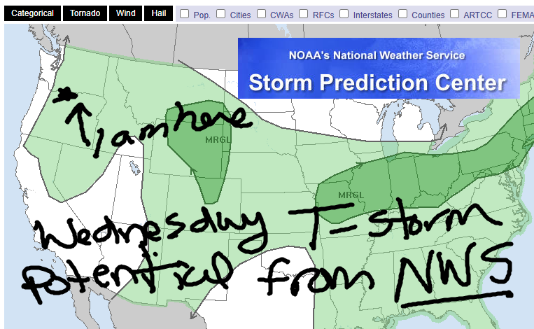
Hi friends! Happy Tuesday! We have a day of moderate west wind today followed by some chaos on Wednesday and Thursday as several factors combine to destabilize the atmosphere and potentially fire off some thunderstorms. That said, these are elevated storms, and won’t necessarily shut down the surface wind as they’re building. More stable weather is in the Gorge wind forecast Friday onward – westerlies look strong this weekend and into the early part of next week, when there’s more uncertainty but still good potential.
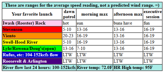
Tuesday started with pressures of 30.15/30.07/30.07 for onshore gradients of 0.08/0.00. That should be just enough for some of you today. Viento was in the low 20s to start the day. Westerlies fill in at 16-19 from Viento to the Hatch for a couple hours this morning with 13-16mph at Stevenson and possibly Hood River. The wind dips late morning or early afternoon to 13-16mph from Stevenson to Hood River in response to metro area heating. Afternoon wind rises to 16-19mph between Stevenson and Doug’s in response to triple-digit heat in the desert. River flow over the last 24 hours was 100-143kcfs, river temp is 72.0F (poor salmon), and high temp forecast is 95F for Hood River. HOT!
RIVER FLOW FOR SITES BETWEEN AVERY (EAST OF THE DALLES) AND RUFUS: CLICK HERE FOR JOHN DAY DAM FLOW.
RIVER FLOW FOR SITES BETWEEN STEVENSON AND DOUG’S BEACH (WEST OF THE DALLES): CLICK HERE FOR THE DALLES DAM FLOW

tomorrow’s gorge wind forecast
Thunderstorm potential enters the picture on Wednesday and makes the forecast tricky. Early wind looks like 19-22mph from Viento to the Hatch. Midday: 17-20mph between Stevenson and Mosier with 14-17mph from Lyle to Doug’s. Thanks to very hot weather in the desert, we could see 20-23mph from Stevenson to Doug’s in the evening, but that’s low probability given the potential for thunderstorms. High temp: 95F for Hood River unless clouds build early and limit heating.
extended Gorge wind forecast
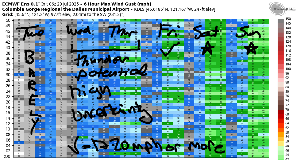
Elevated instability lingers into Thursday and gives us a low-reliability forecast. A massive cross-Cascade temp gradient (and strong wind) is possible, but that’ll only happen if clouds are minimal in the desert. Clouds, thunder, and maybe even rain are possible out there. The GFS gives us a massive day (29-33mph), but I’m very skeptical of this given the thunder potential. The Euro ensembles are calling for 20-24mph. So… wind is likely for at least part of the day, but there’s no way to predict the strength accurately. Some goes for the high temps!
A more stable setup returns to the west side on Friday as marine air pushes in. Out in the desert, instability and thunderstorm potential continues. Once again, there’s a lot of uncertainty in the forecast. Generally speaking, the Stevenson-Doug’s zone is likely to be your best bet as the desert may destabilize. 20-25mph average speeds seem likely. I’m hedging. A big Hatch Dawn Patrol is a possibility. Starting Saturday, instability clears the region, marine clouds intrude on the west side, and heat lingers in the desert. Moderately strong to strong wind is likely Saturday and Sunday with good potential for Monday as well. Uncertainty increases in the models starting on Tuesday, but most of them keep the wind going for at least a few more days. Sounds like a darn fine stretch of wind to me. See you on the Nch’i Wana!
Was that helpful? I knew it was! Guess what? All of this crucial work – from your personal wind and snow reports to the invaluable TATAS updates – is made possible by my relentless efforts. Maintaining this labor of love isn’t easy. Each daily forecast takes hours. Website hosting, weather model access, and back-end admin work takes time and money. That’s where you come in.
YOUR CONTRIBUTION MAKES A DIFFERENCE
- SUPPORT ACCURATE, HYPER-LOCAL WEATHER FORECASTING
- ENABLE ACCESS FOR ALL, EVEN THOSE WITH LESS MEANS
- SUPPORT A COOL HUMAN WHO WORKS HARD SO YOU CAN PLAY
Take a moment to click one of the buttons below. Donate $19.99 or more (how much does this forecast enhance your life?) and get the email in your inbox. Whether it’s a renewing subscription (auto-renew) or a one-time donation, every contribution makes a real difference. Help me keep this labor of love alive, so we can all continue playing, commuting, and living in the Gorge with peace of mind and the best weather forecasts possible. Thank you!


Hood River, Oregon 97031


JONES BEACH, SAUVIE ISLAND, & COAST FORECAST
Wind northerly unless otherwise indicated. For coast, it’s North/Central/South with the “central” at approximately Florence. Swell forecast from NWS for central coast. Jones: westerly unless otherwise stated. Sauvie Island: northerly unless otherwise stated. Coast Tuesday: NNW15/NNW15/N25-30, NW swell 2′ at 8 seconds. Wednesday: 15-20/10-15/25-30, W 2′ @ 8. Thursday: LTNW/LTNW/N25-30, W 2′ @ 17. Jones Tuesday: 20-23. Wednesday: 23-26. Thursday: 17-20. Sauvie Island Tuesday: 13-16. Wednesday: 14-17. Thursday: 16-19 (+ thunder chances).
BARE BONES HOOD RIVER WEATHER FORECAST
Clear sky this morning adds a few high clouds later. Temps start in the upper 50s (open windows) and finish in the mid 90s (close windows). Moderate westerlies. No rainbows. Wednesday will be partly high cloudy early with a chance of thunderstorms later. Temps star tint he mid 60s and rise to the mid 90s (maybe – depends on cloud cover). Moderate westerlies. 2% chance of rainbows. Thursday will be cloudy with a chance of thunderstorms. Temps start in the mid 60s and rise to the low 80s. West wind of some sort, potentially strong. 6% chance of rainbows.
TEMIRA’S AWESOME TRAVEL ADVISORY SERVICE – TUESDAY 7/29
HYPERLOCAL WEATHER FORECAST FOR THE COLUMBIA GORGE
THE DALLES, HOOD RIVER, WHITE SALMON, TROUT LAKE, STEVENSON, CASCADE LOCKS, PARKDALE, ODELL, HUSUM, BZ, MILL A, WILLARD, GOLDENDALE, RUFUS, ARLINGTON, boardman
Good morning, neighbors! We’ve got a hot one on tap today, and then we tumble like a three-year-old gymnast into disorganized weather for the next couple of days. Thunderstorms are possible both Wednesday and Thursday. Negative possibility: lightning. Positive possibilities: cooler temps and maybe some rain. Combine the positive and the negative and you get … thunder! Looking out past Thursday, the weather settles down, and it also cools down – high temps drop below 90 for almost all of us. Accompanying that cooler weather will be strong west wind day after day.
GLENWOOD THIS MORNING
Tuesday started off nice and cool: 59 degrees at my house, and 46 degrees in Glenwood, where everyone named “Glen” is playing with their morning wood. Everyone else is chopping wood in preparation for those bitterly cold Glenwood winter mornings. It’s a good thing it’s always cool in the morning in Glenwood – cool weather is great for working up a sweat while chopping wood!
TODAY’S GORGE WEATHER FORECAST
By afternoon, it’ll be hot everywhere, including in Glenwood. Temps max out in the mid 90s (west) and low triple digits (The Dalles and out in the desert). West wind rises to 15-20mph between Stevenson and Hood River this morning and between Stevenson and Murdoch this afternoon. Up in the hills, you’ll find NW wind at 10mph in the lower elevations and E wind at 10mph at higher elevations. A few high clouds pop up this afternoon like (sour cherry ghost pepper flavor) pop tarts in a toaster. Those clouds are responding to increasing moisture aloft. You should respond to this by hydrating. At the surface, the dewpoint climbs to 53 degrees on the west side this afternoon, which will make you sweat like … well, like me out in my garden burying pumpkin vines.
WEDNESDAY’S GORGE WEATHER FORECAST
Exciting weather is possible on Wednesday late in the day as moisture, southerly flow, and 20kts of shear combine with an incoming disturbance for thunderstorm potential. With high clouds and high dewpoints (51-54 degrees) likely early, we’ll start off warm and muggy, perhaps 65 degrees. Models call for just as much afternoon heat as on Tuesday, but increasing clouds and thunder potential could result in lower high temps than forecast. Maybe. West wind sticks around at 15-20mph all day between Stevenson and Hood River and fills in as far east as Murdoch in the afternoon. One last thing: our most spectacular sunsets occur with atmospheric instability and thunderheads, so be ready for that potential!
EXTENDED GORGE WEATHER FORECAST
Instability continues all night Wednesday and lingers into Thursday. We’ll have a warm and muggy start (mid 60s or warmer). Humidity, multi-level clouds (these are different than multi-level marketing schemes), and thunderstorm chances stick around all day. Wind strength will depend on how much heat the desert can muster up in the face of all this cloud cover. If it’s wicked hot out there where the Bighorn Sheep roam, it’ll be wicked windy along the river all the way from Stevenson to the desert. If it’s not wicked hot, it won’t be wicked windy! And if you see anything wicked happening, respond with kindness and firmness to mitigate the damage.
Starting Friday, we’ll be in a cooler, rather stable pattern West side temps will be within a few degrees of 80, and they’ll probably be coolest on Sunday, when forecast highs are just 77F for Hood River. Fuck yeah! The Dalles: probably under 90 degrees each day. Add in low clouds on the west side and sunshine in the desert for a string of very windy days this weekend. That’s all for now. Safe travels. -TATAS
HEY! DON’T STOP READING! Is this community-focused forecast helpful to you? It sure is! It takes me a couple hours a day to write. Please join your friends and neighbors in contributing to keep it going. Venmo: @thegorgeismygym PayPal: twomirrors@gmail.com USPS: Temira / PO Box 841 / Hood River, Oregon 97031 You can test out the forecast subscription for a few days for free by signing up below. Easy! Do it!
