

GORGE WIND FORECAST
today’s gorge wind forecast
Hi friends! Are you well rested? I hope so! We’ve got several days of strong wind coming up in the Gorge wind forecast… Today through Thursday look strong. Friday and Saturday will be far from light. Looking at Sunday, we see lots of uncertainty, and the lack of clarity continues into next week. It’s also worth mentioning that high temps will be trending downward this week, and they’ll fall to 70 or so by Friday, so don’t put away your wetsuits yet!
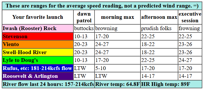
Tuesday started off windy with pressures of 29.96/29.82/29.79. That gives us gradients of 0.14 (wow) and 0.03. The metro area was cloud-free to start the day, and with nothing around to change that, we’re likely to see a midday lull near the Hatch. So, get on it. Westerlies quickly rise to 24-27 from Stevenson to Mosier this morning. East of there, not much happens early – maybe 10-13mph. Come early afternoon, the wind is likely to drop to gusty 18-22 between Swell and Hood River while Stevenson, Viento, and Mosier hold in the 24-27 range. From Mosier to Avery, the wind holds at 24-27 this afternoon. Rufus rises to 17-20, and areas east of Rufus will be under 15mph until evening when Arlington rises to 20-23. Models do hint at a resurgence of wind between Stevenson and Hood River this evening, perhaps 23-26 if we’re really lucky, but more likely low 20s. River flow over the last 24 hours was 157-214kcfs (181-214kcfs at Rufus), river temp is 64.8F, and high temp forecast is 89F for Hood River and 94F for Arlington.

tomorrow’s gorge wind forecast
Supportive conditions stick around for Wednesday: offshore high pressure, a heat low in the desert… On the downside, marine clouds are unlikely in the metro area, so a midday lull is possible near the Hatch. TJ’s Dawn Patrol looks like 26-29 from Viento to Mosier with 13-16 east of Mosier all the way to Arlington. TJ will be very happy! By early afternoon, the Mosier-Avery stretch rises to 29-32 with 26-29 (still very windy!) on the lower-reading sensors between Stevenson and Hood River. Afternoon: the west side, Stevenson to Hood River, is likely to drop to gusty 18-22 (unless we get unexpected marine clouds to the west) while 29-32 fills in from Mosier to Avery with 24-27 at Rufus and 20-23 at Arlington. Models are again hinting at a return to strong wind for the Stevenson-Hood River zone in the evening. Call it 24-27 for the Executive Session. High temp: 81F for Hood River and 94F for Arlington.
extended Gorge wind forecast
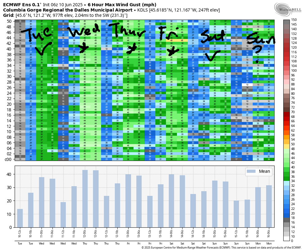
Thursday brings another round of very strong west wind. Models are hinting at marine clouds for the metro area in the morning. If that’s the case, we’ll see more persistent wind for the Corridor (Swell to Hood River). We’ll also see a chance for the strongest wind, 29-32, to extend to Rufus in the afternoon. We’ll take a closer look at it as we get closer, but for now, just plan on another nuking day. High temp: 76F for Hood River and 81F for Arlington. Deeper marine layer penetration and longer-lasting clouds is the Gorge wind forecast for Friday. As of now, we’re looking at 25-28, but it’s possible we’ll beat that.
Weekend: Saturday looks similar. Model agreement falls apart on Sunday as the ensembles offer up a chance of both ridging (warm and less windy) and troughing (cool and windier). Ditto for next week – too much uncertainty now to really take a guess at what’ll happen. For now, let’s all fuel up and get ready for a stretch of Classic Gorge Setup. See you on the Nch’i Wana!
Was that helpful? I knew it was! Guess what? All of this crucial work – from your personal wind and snow reports to the invaluable TATAS updates – is made possible by my relentless efforts. Maintaining this labor of love isn’t easy. Each daily forecast takes hours. Website hosting, weather model access, and back-end admin work takes time and money. That’s where you come in.
YOUR CONTRIBUTION MAKES A DIFFERENCE
- SUPPORT ACCURATE, HYPER-LOCAL WEATHER FORECASTING
- ENABLE ACCESS FOR ALL, EVEN THOSE WITH LESS MEANS
- SUPPORT A COOL HUMAN WHO WORKS HARD SO YOU CAN PLAY
Take a moment to click one of the buttons below. Donate $19.99 or more (how much does this forecast enhance your life?) and get the email in your inbox. Whether it’s a renewing subscription (auto-renew) or a one-time donation, every contribution makes a real difference. Help me keep this labor of love alive, so we can all continue playing, commuting, and living in the Gorge with peace of mind and the best weather forecasts possible. Thank you!


Hood River, Oregon 97031


JONES BEACH, SAUVIE ISLAND, & COAST FORECAST
Wind northerly unless otherwise indicated. For coast, it’s North/Central/South with the “central” at approximately Florence. Swell forecast from NWS for central coast. Jones: westerly unless otherwise stated. Sauvie Island: northerly unless otherwise stated. Tuesday: 15/15-20/25, NW swell 8′ at 10 seconds. Wednesday: 10/10/25, NW 7′ @ 9. Thursday: 20/15-20/25-30, NW 6′ @ 9. Jones Tuesday-Thursday: 23-26. Sauvie Island Tuesday: 4-17. Wednesday: 15-18. Thursday: 17-20.
BARE BONES HOOD RIVER WEATHER FORECAST
Mostly clear sky with a few high clouds today. Temps start in the low 60s and rise to the upper 80s. Strong westerlies. No rainbows. Wednesday will be partly high cloudy. Temps start in the upper 50s and rise to the low 80s. Strong westerlies. No rainbows. Thursday will be partly cloudy then clear. Temps start in the low 50s and rise to the mid 70s. Strong westerlies. No rainbows.
TEMIRA’S AWESOME TRAVEL ADVISORY SERVICE
HYPERLOCAL WEATHER FORECAST FOR THE COLUMBIA GORGE
THE DALLES, HOOD RIVER, WHITE SALMON, TROUT LAKE, STEVENSON, CASCADE LOCKS, PARKDALE, ODELL, HUSUM, BZ, MILL A, WILLARD, GOLDENDALE, RUFUS, ARLINGTON, boardman

Good morning, neighbors! It’s Tuesday, and first things first: let’s all do a quick pinky swear to not burn anything over the next five days. Most of us are under a red flag warning for super-high fire danger thanks to strong wind and unseasonably dry conditions. Nobody thinks they’ll be the one to start a massive wildfire, but any of us could with a careless toss of a cigarette butt, a spark caused by a mower hitting a rock, a dragging trailer chain, or a campfire that’s not fully extinguished. As of right now, there are no live fires on WatchDuty for the Gorge. Let’s keep it that way! Next up: today is Tum-A-Lum Hood River’s customer appreciation day. The fun starts at 11am with tool demos, a BBQ, and a raffle.
Today’s gorge weather forecast and glenwood’s opening gambit
I can sum up the weather for the next few days like this: very windy, dry, with high temps dropping about 5 degrees each day. Before we dive into the details, let’s say hello to our friends in Glenwood. “Hi, friends in Glenwood!”. They didn’t respond because it’s 47 degrees there and everyone is busy shooing the cool air into their homes in anticipation of a hot afternoon. And so it shall be: temps rise to the upper 80s (west) and mid 90s (east) today. West wind rises to 25-30mph all the way from Stevenson to Avery this afternoon with 15-20mph east of Avery to Rufus and perhaps the Arlington Triangle, where Full Bush In A Bikini is embraced like an early morning cuddle with a cat.
tomorrow’s gorge weather forecast
Wednesday brings even more wind and even cooler temps. After a lovely, 50-something degree start, temps rise to 80 (west), 86 (east), and the mid 90s (Hermiston area). This temp spread results in west wind at 30 from Viento to Mosier early with 15mph east of Mosier to Arlington. Afternoon wind builds to 30-35mph all the way from Stevenson to Arlington. Thursday looks nearly identical in terms of wind and the danger of wildfires spreading quickly, but temps will be down another notch: mid 70s for the west, low 80s near The Dalles, and upper 80s way out in the watermelon growing zones near Hermiston, the Tri Cities, and Pasco.
extended gorge weather forecast
In a fun twist, the western Gorge might even see some clouds on Friday morning. Rain? No, no rain for you. The next chance of that is around the 17th, and only about 20% of the models have measurable rain for any of us. Back to this Friday… windy, yet again, but only 70-75 degrees. PERFECT! Same for Saturday. Model agreement falls apart on Sunday, so I’ll leave you for now. Have a beautiful day. Safe travels. -TATAS
HEY! DON’T STOP READING! Is this community-focused forecast helpful to you? It sure is! It takes me a couple hours a day to write. Please join your friends and neighbors in contributing to keep it going. Venmo: @thegorgeismygym PayPal: twomirrors@gmail.com USPS: Temira / PO Box 841 / Hood River, Oregon 97031 You can test out the forecast subscription for a few days for free by signing up below. Easy! Do it!
