

GORGE WIND FORECAST
If you’re still seeing yesterday’s and it’s after 9am, try opening this in an incognito window
today’s gorge wind forecast
Hi friends! We’ll have east wind today, light/variable wind tomorrow, and then a big west wind day on Thursday. Friday still shows model disagreement, but I’m comfortable calling for enough west wind to get you on the water. A rest day pops up in the schedule on Saturday, and then a strong cold front and associated elevated wind drive eastern Gorge westerlies on Sunday. Whew. It’s ain’t over ’til it’s over!
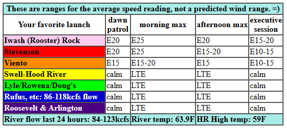
Tuesday morning started with easterlies at 20mph at both Iwash (Rooster) Rock and Stevenson with Viento lagging just a couple mph behind. Mid-morning wind builds to 25mph at Iwash, 20-25mph at Stevenson, and 20mph at Viento. We’ll have a few hours of that before the fade kicks in. Still… Stevenson/Iwash hold at 20mph into early afternoon before fading to 10-15mph (Stevenson) and 15-20mph (Iwash) this evening. River flow over the last 24 hours was 84-123kcfs, river temp is 63.9F, and high temp forecast is 59F.
RIVER FLOW FOR SITES BETWEEN AVERY (EAST OF THE DALLES) AND RUFUS: CLICK HERE FOR JOHN DAY DAM FLOW.
RIVER FLOW FOR SITES BETWEEN STEVENSON AND DOUG’S BEACH (WEST OF THE DALLES): CLICK HERE FOR THE DALLES DAM FLOW

tomorrow’s gorge wind forecast
Wednesday starts with easterlies at 15mph at the usual spots. That doesn’t last long at all. After a light/variable period in the middle of the day, westerlies slowly build to 10mph between Stevenson and The Dalles. High temp: 65F.
extended Gorge wind forecast
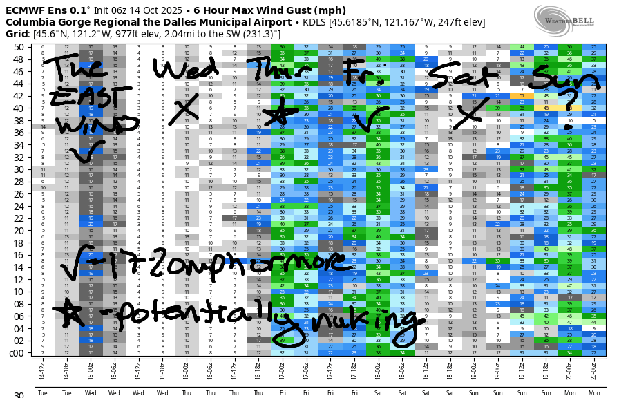
A system pushes down from the NNW on Thursday and reinforces the marine layer into late morning. Result: strong to nuking westerlies in the Corridor in the morning and all the way from Stevenson to Arlington and beyond in the afternoon. TJ’s dawn patrol looks like 25-28mph from Viento to Mosier with 17-20mph from Lyle to Rufus and low teens in cloudy Stevenson. Westerlies build to 28-32mph between Stevenson (maybe – might be too cloudy) and Lyle mid-morning with 25-28mph at Rufus. Afternoon: 28-32mph from Stevenson to Arlington with 25-28mph at Threemile. Given the cold, dense air on the west side and the relative warmth in the desert, 30-35mph between Rowena and Rufus is within range. High temp: 63F in Hood River and 65F at Rufus.
Models STILL disagree about Friday – the GFS insists it won’t be windy, and the ECMWF insists it will. With offshore high pressure in the cards, low clouds on the west side, and sun in the desert, I’ll lean towards the Euro. For now, let’s call it 25-28mph and revise as we get closer. Looking at Saturday, we have a brief ridge of high pressure ahead of an approaching (strong) system for Sunday. Timing on this system still isn’t clear. If the timing is right, we’re likely to see a big day in the desert on Sunday as cold air on the west side combines with strong to very strong upper-level wind and significant downsloping. What does all that mean? Avery to Arlington, my friends. Too bad I’ll be out of town. You’ll have to get it for me! But hey, I’ll see you out there Thursday and Friday. Have a great day today!
Was that helpful? I knew it was! Guess what? All of this crucial work – from your personal wind and snow reports to the invaluable TATAS updates – is made possible by my relentless efforts. Maintaining this labor of love isn’t easy. Each daily forecast takes hours. Website hosting, weather model access, and back-end admin work takes time and money. That’s where you come in.
YOUR CONTRIBUTION MAKES A DIFFERENCE
- SUPPORT ACCURATE, HYPER-LOCAL WEATHER FORECASTING
- ENABLE ACCESS FOR ALL, EVEN THOSE WITH LESS MEANS
- SUPPORT A COOL HUMAN WHO WORKS HARD SO YOU CAN PLAY
Take a moment to click one of the buttons below. Donate $19.99 or more (how much does this forecast enhance your life?) and get the email in your inbox. Whether it’s a renewing subscription (auto-renew) or a one-time donation, every contribution makes a real difference. Help me keep this labor of love alive, so we can all continue playing, commuting, and living in the Gorge with peace of mind and the best weather forecasts possible. Thank you!


Hood River, Oregon 97031


JONES BEACH, SAUVIE ISLAND, & COAST FORECAST
ON WINTER VACATION. WILL RETURN AS NEEDED.
BARE BONES HOOD RIVER WEATHER FORECAST
Clear sky today. Temps start in the low-mid 30s and rise to the upper 50s. Light easterlies. No rainbows. Wednesday will be partly Nothing then clear. Temp start in the low-mid 30s and rise to the mid 60s. Light easterlies. Then light westerlies. No rainbows. Thursday will be partly cloudy. Temps start in the upper 30s and rise to the low 60s. Strong to very strong westerlies. No rainbows.
TEMIRA’S AWESOME TRAVEL ADVISORY SERVICE
HYPERLOCAL WEATHER FORECAST FOR THE COLUMBIA GORGE
THE DALLES, HOOD RIVER, WHITE SALMON, TROUT LAKE, STEVENSON, CASCADE LOCKS, PARKDALE, ODELL, HUSUM, BZ, MILL A, WILLARD, GOLDENDALE, RUFUS, ARLINGTON, boardman
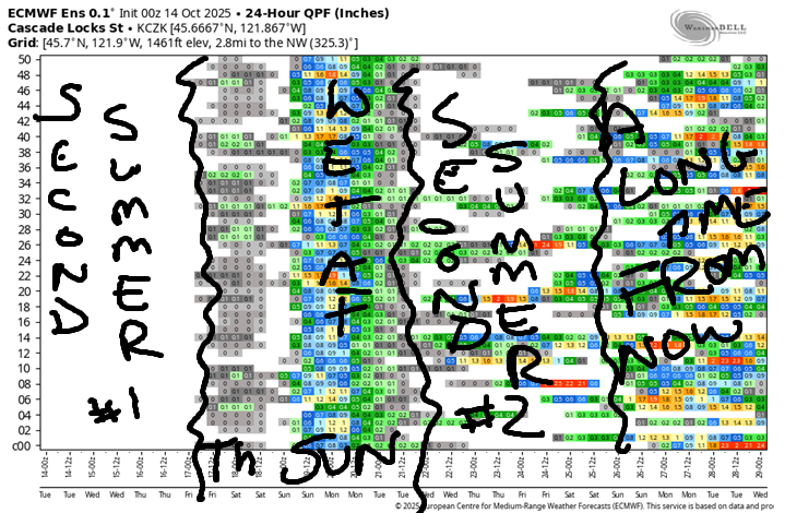
Good morning, neighbors! It’s frosty morning in many, many locations of the Gorge to start Tuesday. Tuesday, by the way, is my FAVORITE day of the week! Anyway, now that we’ve had a frost, it’s time to start “second summer” or “St. Martin’s Summer”, a term that is apparently related to St. Martin sharing his cloak on a cold day. Ah yes, it’s the small acts of kindness that make the difference…
Glenwood this morning
Looking around the region this morning (NO, NOT YOUR NETHER REGION – DO THAT ON YOUR OWN TIME) we see many, many locations below freezing. Temps have been bouncing around a bit, but the coldest spot this morning is… NOT GLENWOOD! As a matter of fact, when I just looked, it was 36F in Glenwood. Centerville is currently winning with 28F. Upper Hood River Valley: 30-35F depending on elevation. My garden: hard to tell – there are four sensors close to there, and they are reading anything from 29F to 34F. I think that’s it for tomatoes and peppers!
Today’s Gorge weather forecast
For the rest of today, we’ll have a brilliant fall day to celebrate garden cleanup days. “Garden Cleanup Day” is any day between when you plant the garden and when it’s covered in snow. Today’s weather will be perfect for it: temps max out in the upper 50s (Hood River), low 60s (The Dalles) and 60F (way out east where the watermelon beds are being put to bed for the winter). Wind will be E 30mph near Cock Rock this morning with 25mph near Stevenson. Afternoon: 15-20mph near Wiener Rock and 10-15mph near Stevenson. Everywhere east of Viento: light east wind today.
Wednesday’s Gorge weather forecast
Overnight: clear and chilly with light wind and another chance of frost. We’ll wake up to mid 30s or less on Wednesday morning under mostly clear sky. A little Nothing near the Nch’i Wana (Big River) can’t be ruled out, bu the vast majority of the day will subject you to the vastness of the big, blue sky. Temps rise to the mid 60s in the lowlands. Wind will be east at 15mph near Iwash/Stevenson in the morning and west at 10mph between Stevenson and The Dalles in the afternoon. Elsewhere, the wind will be light and variable. A few high clouds arrive in the afternoon just in time to add some color to the sunset.
Extended Gorge weather forecast
Thursday looks different: 40 degrees to start, 63-67F to finish, and really, really windy. Really windy weather really kicks in mid-morning when westerlies rise to 25-35mph between Viento and Mosier. The wind fills in all the way east to the Arlington Equilateral Triangle in the afternoon. Low clouds stick around all day west of Hood River. They’re joined by additional cloud layers in the afternoon: low, medium, and high clouds to the west and just high clouds to the east. But not rain. You’ll have to wait until late Saturday or perhaps Sunday for that.
Friday: similar in many ways to Thursday. Saturday: probably dry, increasingly cloudy, not very windy, and rather warm – 65-68 degrees. That’s PERFECT for the No Kings protests happening all over the Gorge: Stevenson, Hood River, Bingen, and The Dalles. As a matter of fact, there are THOUSANDS of protests registered across the country on Saturday. Down with the oligarchy. Power back to the people!
On Sunday, we’ve got colder, wetter, winder weather in the cards. After that: yet another “second summer” and another round of garden cleanup. Get those cover crops in, people. Safe travels. -TATAS
HEY! DON’T STOP READING! Is this community-focused forecast helpful to you? It sure is! It takes me a couple hours a day to write. Please join your friends and neighbors in contributing to keep it going. Venmo: @thegorgeismygym PayPal: twomirrors@gmail.com USPS: Temira / PO Box 841 / Hood River, Oregon 97031 You can test out the forecast subscription for a few days for free by signing up below. Easy! Do it!
MT HOOD SNOW FORECAST

CURRENTLY ON VACATION. WILL RETURN SOMETIME BEFORE THE START OF SKI SEASON AT MEADOWS, TIMBERLINE AND SKIBOWL. SAME GOES FOR THE NORDIC SKIING SEASON AT MEADOWS AND TEACUP!
