

GORGE WIND FORECAST
If you’re still seeing yesterday’s and it’s after 9am, try opening this in an incognito window
today’s gorge wind forecast
Hi friends! A couple rest days are on tap for most of us as the wind switches directions and stays below 15mph for most of the next 48 hours. While yesterday’s model run had hope for westerlies today, today’s model run dashed that hope. West wind returns to the Gorge wind forecast for the long haul on Thursday, sticking around at least through the weekend and probably for longer. A reminder to all the folks recreating on the river: the Gorge Downwind Champs is this week. Watch for lots and lots and lots of outrigger canoes and surfskis shredding downwind!
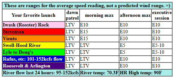
We’re planning on east wind today. For those of you visiting and new to our setup here: easterlies peak in different locations than west wind. Today’s easterlies max out at 15mph for a couple hours late morning or early afternoon near Cascade Locks and Home Valley (10mph at Iwash/Rooster and 10mph at Viento) before dropping to 10mph in the afternoon. East of The Dalles, easterlies rise to 10mph. Near Hood River: somewhere between calm and 5mph. River flow over the last 24 hours was 95-152kcfs (101-152kcfs at Rufus), river temp is 70.30F, and high temp forecast is 90F.
RIVER FLOW FOR SITES BETWEEN AVERY (EAST OF THE DALLES) AND RUFUS: CLICK HERE FOR JOHN DAY DAM FLOW.
RIVER FLOW FOR SITES BETWEEN STEVENSON AND DOUG’S BEACH (WEST OF THE DALLES): CLICK HERE FOR THE DALLES DAM FLOW

tomorrow’s gorge wind forecast
Wednesday also sees east wind, strongest in the morning. You’ll find 17-20mph at Iwash (Rooster) Rock and 14-17mph at Stevenson, Viento, and Home Valley. By early afternoon, the wind drops to 10-13mph at all those locations. Evening sees the wind go calm all through the Gorge. High temp: 93F and sunny.
extended Gorge wind forecast
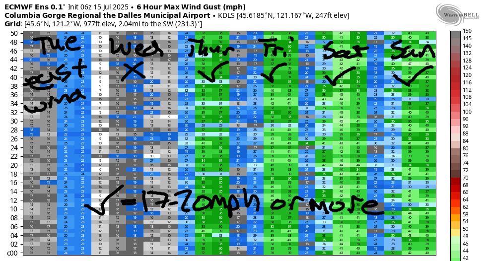
Westerlies return on Thursday as a trough of cooler air arrives from the northwest. For now, models suggest 22-25mph between Stevenson and Mosier in the morning with 23-26 fromm Mosier to Rufus in the afternoon with 17-20mph between Stevenson and Hood River.. Ensembles are in good agreement for 22-25mph or more Friday, Saturday, and Sunday as cool-enough, stable-enough air persists on the west side and heat lingers in the desert. Looks like another good stretch of wind coming this way once we make it through these two rest days! Stay cool out there today. I’ll see ya on the Nch’i Wana!
Was that helpful? I knew it was! Guess what? All of this crucial work – from your personal wind and snow reports to the invaluable TATAS updates – is made possible by my relentless efforts. Maintaining this labor of love isn’t easy. Each daily forecast takes hours. Website hosting, weather model access, and back-end admin work takes time and money. That’s where you come in.
YOUR CONTRIBUTION MAKES A DIFFERENCE
- SUPPORT ACCURATE, HYPER-LOCAL WEATHER FORECASTING
- ENABLE ACCESS FOR ALL, EVEN THOSE WITH LESS MEANS
- SUPPORT A COOL HUMAN WHO WORKS HARD SO YOU CAN PLAY
Take a moment to click one of the buttons below. Donate $19.99 or more (how much does this forecast enhance your life?) and get the email in your inbox. Whether it’s a renewing subscription (auto-renew) or a one-time donation, every contribution makes a real difference. Help me keep this labor of love alive, so we can all continue playing, commuting, and living in the Gorge with peace of mind and the best weather forecasts possible. Thank you!


Hood River, Oregon 97031


JONES BEACH, SAUVIE ISLAND, & COAST FORECAST
Wind northerly unless otherwise indicated. For coast, it’s North/Central/South with the “central” at approximately Florence. Swell forecast from NWS for central coast. Jones: westerly unless otherwise stated. Sauvie Island: northerly unless otherwise stated. Coast Tuesday: 10-15/15/25-30, NW swell 7′ at 9 seconds. Wednesday: 20/20/LTN, NW 6′ @ 8. Thursday: LTW/LTW/n15-20, NW 7′ @ 10. Jones Tuesday: LTW. Wednesday: 16-19. Thursday: 18-21. Sauvie Island Tuesday: 9-12. Wednesday: 11-14. Thursday: 9-11.
BARE BONES HOOD RIVER WEATHER FORECAST
Tuesday will be sunny. Temps start in the upper 50s (open windows) and end near 90 (closed windows). Light easterlies. No rainbows. Wednesday will be sunny. Temps start in the low 60s and rise to the low 90s. Light easterlies. No rainbows. Thursday will be sunny. Temps start in the mid 60s and rise to the upper 80s. Moderately strong westerlies. No rainbows.
TEMIRA’S AWESOME TRAVEL ADVISORY SERVICE – TUESDAY 7/15
HYPERLOCAL WEATHER FORECAST FOR THE COLUMBIA GORGE
THE DALLES, HOOD RIVER, WHITE SALMON, TROUT LAKE, STEVENSON, CASCADE LOCKS, PARKDALE, ODELL, HUSUM, BZ, MILL A, WILLARD, GOLDENDALE, RUFUS, ARLINGTON, boardman
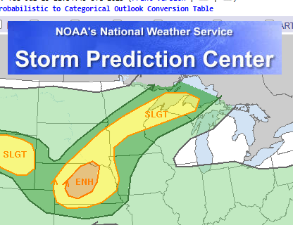
Good morning, neighbors! Who’s up for another spell of hot weather? You? Excellent, because that’s what we’re all getting. In a break from the norm, the metro area will be hotter (about 5 degrees hotter) than the Gorge for the next couple of days. But we’ll still be hot, hot enough for you to pencil in “swimming hole visit” on your calendar for the next few days. While it’s going to be hot here, at least we’re not getting screwed like the Great Lakes region, where the UP is getting penetrated by a slight risk of severe thunderstorms today.
GLENWOOD THIS MORNING
This morning, though, nobody’s hot. You’d have to go east of John Day Dam to find anyone who spent the night above 70 degrees. Most of us dropped into the 50s, which makes this a great morning to open your home to Ma Nature’s AC. Glenwood started at 47 degrees this morning, which is actually quite warm given the clear sky, relatively cool air aloft, and calm wind. I tried to send my drone to Glenwood this morning to check on folks, but it wasn’t able to get there. It might be that everyone is wearing tinfoil hats this morning to thwart drones, but it also might be that I don’t actually own a drone.
TODAY’S GORGE WEATHER FORECAST
By this afternoon (it’s Tuesday), temps climb to 90 (west and east) and 95 (The Dalles). We’ll have light/variable wind early, easterlies at 10-15mph near Stevenson and Cascade Locks midday, and easterlies at 10mph all the way from Iwash (pen*s) Rock to the eastern Gorge this afternoon. In an interesting twist, the sounding model has easterlies at 20-35mph in the hills overnight which will lessen radiational cooling and leave us warmer Wednesday morning than Tuesday morning.
WEDNESDAY’S GORGE WEATHER FORECAST
Wednesday looks just-plain-hot. After a 60ish degree start, temps rise to the low-mid 90s. East wind will be 20mph near Iwash (cock) Rock in the morning and 15mph between Cascade Locks and Viento. The wind fades during the day and ends calm. Sky: clear all day. One thing to note with the east wind: depending on the exact direction of the easterlies, it could blow smoke this way from the 28,000 acre Cram Fire and a couple of smaller fires in Idaho.
EXTENDED GORGE WEATHER FORECAST
Thursday’s sky will be clear too, but temps will start to drop on the west side. Highs will be in the upper 80s to the west, mid 90s in The Dalles, and upper 90s out where the watermelons are sucking up water and converting sunshine to sugar. Hopefully someone out there is trying to grow a state record watermelon for OR; the current record is 232lbs. The only thing better than a giant watermelon is a giant pumpkin, many of which are being grown here in the Gorge. Back to the weather: we’ll see west wind at 20-25mph all day on Thursday all the way from Stevenson to Bob’s Texas T-Bone, the location also known as Rufus but known as Bob’s Texas T-Bone for decades. Temps slowly drop through Sunday, when temps might actually be briefly and slightly below normal. That is all for now. Safe travels. -TATAS
HEY! DON’T STOP READING! Is this community-focused forecast helpful to you? It sure is! It takes me a couple hours a day to write. Please join your friends and neighbors in contributing to keep it going. Venmo: @thegorgeismygym PayPal: twomirrors@gmail.com USPS: Temira / PO Box 841 / Hood River, Oregon 97031 You can test out the forecast subscription for a few days for free by signing up below. Easy! Do it!
