

GORGE WIND FORECAST
If you’re still seeing yesterday’s and it’s after 9am, try opening this in an incognito window
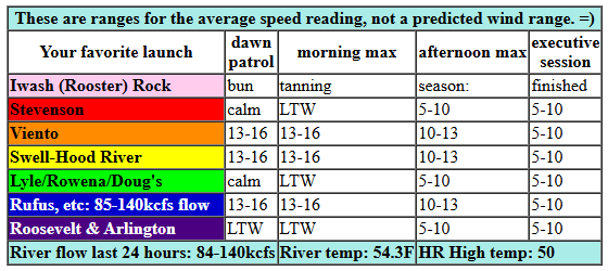
today’s gorge wind forecast
Hi friends! Fall westerlies… so tricky to predict! We’ll have a little lingering west wind this morning, and then we’re back to easterlies for Wednesday. Not much happens for the rest of the week and into the weekend. Every day is looking like 10mph or less. The next chance for anything more exciting that light/variable comes next Monday when about 25-35% of the ensembles members give us strong westerlies with an incoming system. That’s not great odds, but it’s better than zero!
Tuesday starts with lingering west wind in the 13-16mph range from Viento to Swell and from Maryhill to Rufus. Everywhere else is under 10mph. We’ll have a could hours of 13-16mph this morning from Viento to the Hatch or Hood River. What little west wind we have fades as the day progresses; we’ll finish with 5-10mph all through the Gorge this afternoon. River flow over the last 24 hours was 84-140kcfs, river temp is 54.3F, and high temp forecast is 50F with partly cloudy sky.
RIVER FLOW FOR SITES BETWEEN AVERY (EAST OF THE DALLES) AND RUFUS: CLICK HERE FOR JOHN DAY DAM FLOW.
RIVER FLOW FOR SITES BETWEEN STEVENSON AND DOUG’S BEACH (WEST OF THE DALLES): CLICK HERE FOR THE DALLES DAM FLOW

tomorrow’s gorge wind forecast
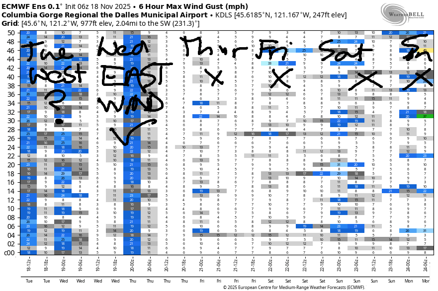
Wednesday sees cold air settle in the desert, and this drives a round of solid and long-lasting east wind. We start the day with 35-40mph at Iwash (Rooster) Rock and 30mph at Stevenson with 20mph at Viento. The wind holds until early afternoon, and even then, it won’t fade much. Stevenson finishes up with 25mph, and Iwash ends the day with 30-35mph. High temp: 49F after a sub-freezing start for many locations.
extended Gorge wind forecast
High pressure settles in for Monday and Tuesday leaving us with clear sky and light/variable or east wind. On Wednesday, an approaching cooler system (details unclear) sets us up for a big thermally-driven afternoon. While there will be some dynamics that lessen results, results still look excellent: 27-31 with the potential for more in select areas. Ensembles have been trending UPWARD in wind speeds – always a good thing. And ensembles are 95% in on a big westerly day. Also a good thing. Go ahead and clear your afternoon. Beyond Wednesday, uncertainty increases, so let’s leave it there for now. See you on the river!
Was that helpful? I knew it was! Guess what? All of this crucial work – from your personal wind and snow reports to the invaluable TATAS updates – is made possible by my relentless efforts. Maintaining this labor of love isn’t easy. Each daily forecast takes hours. Website hosting, weather model access, and back-end admin work takes time and money. That’s where you come in.
YOUR CONTRIBUTION MAKES A DIFFERENCE
- SUPPORT ACCURATE, HYPER-LOCAL WEATHER FORECASTING
- ENABLE ACCESS FOR ALL, EVEN THOSE WITH LESS MEANS
- SUPPORT A COOL HUMAN WHO WORKS HARD SO YOU CAN PLAY
Take a moment to click one of the buttons below. Donate $19.99 or more (how much does this forecast enhance your life?) and get the email in your inbox. Whether it’s a renewing subscription (auto-renew) or a one-time donation, every contribution makes a real difference. Help me keep this labor of love alive, so we can all continue playing, commuting, and living in the Gorge with peace of mind and the best weather forecasts possible. Thank you!


Hood River, Oregon 97031


MT HOOD SNOW FORECAST

Hey skiers and snowboarders! All eyes continue to be on the time period starting next Monday when the Mt Hood snow forecast models are, once again, calling for cooler temps combined with precipitation. That said, there’s quite a bit of range in ensemble predictions for next week, so it’s definitely not a sure thing yet.
Looking at this week: it’s Tuesday, and the mountain will be chilly with sunshine this morning and cloudy this afternoon. The sky clears overnight. A few snowflakes are possible today, but no accumulation. Snow level: 2500′ this morning and 3000′ from this afternoon on into the night. Wind: NW 20-25mph this morning, N 10 this afternoon, and E 15 overnight.
Wednesday sees a weak weather system overnight, but it’ll be too warm to start and too dry to finish. The free air freezing level starts around 3000′. Precip arrives overnight with a snow level of 7500′ to start and then 4000′ after midnight. Up to 0.1” water equivalent is possible, but that won’t result in more than a trace of snow at 5000′. Wind: E 15 in the morning, S 10-20 in the afternoon, and SW 15-25 after midnight.
Light snow Thursday morning drops up to an inch at 5000′ as the snow level holds at 4000′. By the afternoon, clear sky takes over and sticks around all night. Wind: SW 15-25 in the morning, SW 10-15 in the afternoon, and SW 5-10 overnight. Friday looks sunny with the freezing level rising from 3500′ to 6500′. Next round of precip is forecast Sunday night. The intraquartile range (25-75 percentile) calls fro a trace to almost 2” of moisture. In other words, it’s likely we’ll see some snow, but the actual amount is unclear. Beyond that: uncertainty continues, but signs are good for cooler weather, at least. Hope to see you out there soon!
BARE BONES HOOD RIVER WEATHER FORECAST
High clouds this morning give way to mostly clear sky later. Temps start in the mid 40s and rise to 50 or so. Light westerlies. No rainbows. Wednesday will be Nothing then partly cloudy then cloudy. Temps start in the low 30s (freeze warning!) and finish near 50. Light easterlies. No rainbows. Thursday will be cloudy with drizzle in the morning and partly cloudy later. Temps start in the mid 30s and rise to the low 560s. Light easterlies. 12% chance of rainbows.
TEMIRA’S AWESOME TRAVEL ADVISORY SERVICE
HYPERLOCAL WEATHER FORECAST FOR THE COLUMBIA GORGE
THE DALLES, HOOD RIVER, WHITE SALMON, TROUT LAKE, STEVENSON, CASCADE LOCKS, PARKDALE, ODELL, HUSUM, BZ, MILL A, WILLARD, GOLDENDALE, RUFUS, ARLINGTON, boardman
Good morning, neighbors! So far this morning (it’s Tuesday, my favorite day of the week!), it’s an ice-free morning on the roads as best as I can tell. But there might be some frosty or slick spots thanks to sub-freezing temps away from the near-river breeze. Big news for tomorrow: the first widespread freeze. News for the rest of the week: not much news at all as the weather stays seasonably mild and unseasonably dry.
Glenwood this morning
Folks in Glenwood are shaking their heads and rolling their eyes at the freeze warning. So many freezes there already. This morning, for example, brought a low of 25 degrees there. It will be much colder tomorrow!
Today’s Gorge weather forecast
For the rest of us, Tuesday started off with a long-lasting and multi-layered sunrise. That’s long gone, and we now have high clouds. A weak trough swings through today with a period of increased clouds followed by clearing from west to east. Timing looks good for a colorful sunset! Temps rise to 50 (west) and 52 (The Dalles) today with west wind at 5-10mph all day long.
Wednesday’s Gorge weather forecast
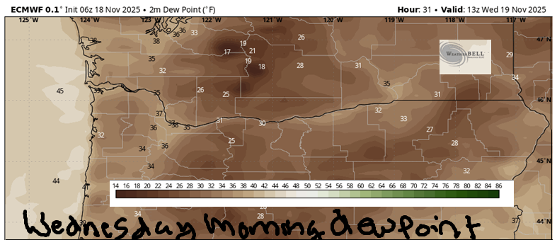
Clear sky overnight combines with dewpoints in the 20s and 850mb temps around 0C for an honest-to-goodness freeze on Wednesday morning. Exceptions: areas west of Hood River where the east wind will stir things up enough to keep the temps above freezing near the Nch’i Wana. Also questionable: locations right along the river and under the sure-to-develop Nothing cloud. Glenwood’s likely to see low 20s on Wednesday morning. Many other locations dip into the upper 20s. Even more of us see low 30s. If you haven’t labeled your dahlias, now’s the time! Temps eventually warm to 50 all across the lowlands on Wednesday as a weak front approaches and spreads clouds like frosting. We’ll have east wind in the usual spots: 35-40mph at Iwash (RELEASE THE FILES) Rock and 30-35mph at Stevenson with 20mph near Viento and lighter wind to the east. Wind lasts until sunset and slowly faces overnight.
Extended Gorge weather forecast
That previously mentioned front moves inland Thursday with a little drizzle for areas west of Mosier in the morning. Temps start in the mid to upper 30s. They’ll rise to the low 50s as the clouds break apart in the afternoon. Wind: light easterly then calm. Friday, Saturday, and most of Sunday look dry, not windy, with high temps in the mid 50s. Models hint at cooler, wetter weather starting Sunday night or Monday, but they’re far from certain about the details. Other than the GFS deterministic (currently an outlier), nothing exciting is planned through the end of the week containing Thanksgiving. Nothing exciting other than pie, that is! Yay, pie! Safe travels. -TATAS
HEY! DON’T STOP READING! Is this community-focused forecast helpful to you? It sure is! It takes me a couple hours a day to write. Please join your friends and neighbors in contributing to keep it going. Venmo: @thegorgeismygym PayPal: twomirrors@gmail.com USPS: Temira / PO Box 841 / Hood River, Oregon 97031 You can test out the forecast subscription for a few days for free by signing up below. Easy! Do it!
JONES BEACH, SAUVIE ISLAND, & COAST FORECAST
ON WINTER VACATION UNLESS DESPERATELY NEEDED.
