

MT. HOOD WEATHER FORECAST

Hey skiers and snowboarders! Cool, cloudy weather is in the cards for the rest of the week, and that’ll keep the groom in great shape: expect a mix of hardpack and packed powder depending on when you go. Best chance for fresh tracks is Wednesday and Thursday – we’re expecting up to 6” of fresh powder in that time period. Next chance for a big dump is about 9-10 days out, in the unreliable zone of forecasting. Fingers crossed. In the meantime…
Tuesday looks like a mostly cloudy day on the hill. Temps are running from the upper teens at Teacup to the single digits on the higher lifts at the resorts. It’ll stay chilly today as the free air freezing level hovers near the surface and temps at 850mb fall to -11C this afternoon. NO measurable snowfall is expected. Wind: SW 10-15 this morning, E 15 this afternoon, and WSW 20 after midnight.
Liking this forecast?
Fresh snow falls on Wednesday, yay! The snow level will be 0′ in the morning, 500′ in the afternoon, and 0-500′ after midnight. Temps at 5000′ will range from the upper teens to the low 20s. Snow starts up around 7am and continues into the night, finally tapering off after midnight. About 0.3” water equivalent (WE) is forecast during the day for 3-4” fresh powder. Same overnight: another 3-4” of powder. Wind: WSW 20 in the morning, SW 15-25 in the afternoon, and WSW 10-15 after midnight.
Thursday stats out with clear sky up high and clouds down low, but light snowfall returns in the afternoon. Overnight, the sky clears for the slopes, but not for the lower elevations. The snow level will be 0′ all day with temps at 5000′ in the upper teens. Just a trace of snow is forecast during the day, but it’s possible we could see a bit more in the evening. Models aren’t sure yet. Wind: WSW 10-15 in the morning, E 15 in the afternoon, and light/variable overnight.
Friday looks dry and cold with some sunshine likely. Looking at the weekend, we see most ensemble members offering up a trace to a quarter inch of precipitation, but enough members are dry that the forecast is still uncertain. The first part of next week looks dry, but more and more ensemble members are suggesting that significant precipitation will return by Tuesday or Wednesday. Stay tuned! See you on the snow!
Was that helpful? I knew it was! Guess what? All of this crucial work – from your personal wind and snow reports to the invaluable TATAS updates – is made possible by my relentless efforts. Maintaining this labor of love isn’t easy. Each daily forecast takes hours. Website hosting, weather model access, and back-end admin work takes time and money. That’s where you come in.
YOUR CONTRIBUTION MAKES A DIFFERENCE
- SUPPORT ACCURATE, HYPER-LOCAL WEATHER FORECASTING
- ENABLE ACCESS FOR ALL, EVEN THOSE WITH LESS MEANS
- SUPPORT A COOL HUMAN WHO WORKS HARD SO YOU CAN PLAY
Take a moment to click one of the buttons below. Donate $19.99 or more (how much does this forecast enhance your life?) and get the email in your inbox. Whether it’s a renewing subscription (auto-renew) or a one-time donation, every contribution makes a real difference. Help me keep this labor of love alive, so we can all continue playing, commuting, and living in the Gorge with peace of mind and the best weather forecasts possible. Thank you!


Hood River, Oregon 97031


GORGE WIND FORECAST

Hi friends! Not much is happening in the wind world for the next week or longer, and temps will remain quite chilly. Tuesday starts with light/variable wind and flat gradients from PDX to DLS. The wind picks up to 20mph at Stevenson this afternoon with 15-20mph at Iwash (Rooster) Rock. East of Hood River, easterlies pick up to 10-15mph this afternoon. River flow over the last 24 hours was 89-127kcfs, river temp is 39.56F, and high temp forecast is 38F with clouds all day.
Wednesday brings easterlies at 15mph in the morning at both Stevenson and Iwash. The wind drops to 10mph at Stevenson in the afternoon and falls into the “light” zone at Iwash. High temp: 37F with snow all day. Thursday sees max easterlies mid-morning at 25mph at both Stevenson and Iwash. East of Hood River, the wind picks up to E 10-15mph. High temp: 37F, mostly cloudy, with snow flurries. While some ensemble members hint at westerlies on Friday, others do not. It really depends on the exact strength and path of an incoming low pressure system. Beyond Friday, things generally look easterly and cold for the extended period. Have a great day today!
BARE BONES HOOD RIVER WEATHER FORECAST
Cloudy and dry today. Temps start in the low 30s and rise to the upper 30s. Light easterlies. No rainbows. Wednesday brings light to moderate snowfall all day. Temps start in the low 20s and rise to the mid 30s. Light easterlies. No rainbows. Thursday brings light snow flurries for much of the day. Temps start in the mid 20s and rise to the mid to upper 30s. Easterlies. No rainbows.
TEMIRA’S AWESOME TRAVEL ADIVSORY FORECAST (HYPERLOCAL FORECAST FOR THE COLUMBIA GORGE)
Good morning, neighbors! It’s a cloudy one out there this morning, and cloudy it shall stay. Far more interesting weather is forecast tomorrow – snow! Beyond that, cold weather sticks around for a while. Models have some potential for FAR more interesting weather starting the middle of next week, but you know how those long-range forecasts are… changeable…
Let’s check in with Glenwood, the unchangeable center of the universe. It’s quite warm there this morning compared to many other places – 26 degrees with a dewpoint of 19 degrees. Glenwood, if you were wondering, has a population of 220. Next up: today’s TATAS Executive Order. With one fell swoop of my Uniball Micro Signo, I have created a Bureau of Food Security that directs public agencies to expedite the creation of community gardens on fallow and/or unused public lands. You’re welcome. (Hey, we all have our pet projects!)
TUESDAY
Tuesday’s weather looks rather blah. A few snow flurries are possible in the “official” Gorge (the National Scenic Area). To the east, the edge of an atmospheric river drops a bit of snow from the Tri-Cities eastward this evening. South Wasco and Sherman counties should see a trace to 2” of snow tonight with the highest accumulations to the south. High temps at river level rise to the upper 30s today. Easterlies peak at 15-20mph in the usual spots with 10-15mph east of Hood River and also in the SW/Sherm zone. That’s my new abbreviation for “South Wasco and Sherman Counties” which is way to fucking long to type (or read) repeatedly.
WEDNESDAY, SNOWY WEDNESDAY
Overnight temps fall to the low-mid 20s tonight as the sky at least partly clears. That sets us up for a long-lasting snowfall on Wednesday starting a bit before sunrise. Once the snow starts, it continues until midnight or so. Models do hint at temps rising enough to switch the p-type to snain in the afternoon at river level, but above 500′, you’re staying snow. And honestly, I’m skeptical of a switch to anything but wet, sloppy snow.
Totals: 3-6” for Corbett, Stabler, Mill A, York Hill, Parkdale, Middle Mountain, west side Hood River, Hood River Mountain, Trout Lake, Snowden, Underwood, Odell, Husum, BZ, Glenwood and other associated areas. Highest totals will be to the west and near Parkdale. Lyle, The Dalles, Rowena, Mosier, Appleton, etc: 1-2”. To the east, trace to 2” for Biggs and trace to 1” east of there. South Wasco and Sherman: trace to 1.5”. Down along the river: 2-4” to the west and a trace to 1” far east. Hopefully you can figure out your hyperlocal forecast from those guesses. For much of the day, the snowfall intensity should be high enough west of Hood River to make for slushy roads. Wind: E 15mph in the usual spots in the morning with light east wind later.
THURSDAY AND THE WEEKEND
Partly cloudy sky after midnight Wednesday into Thursday morning ices up all the roads. With clear sky possible in Glenwood, we might have some exciting numbers to talk about! After a dry start, light snowfall returns and sticks around for much of the day from The Dalles westward. Accumulations will be small – maybe an inch or so. High temps rise to the mid 30s. East wind picks up to 25mph in the usual spots with 10-15mph east of Hood River and in the hills and also, yup, SW/Sherm. Dry weather returns on Friday with a potentially very chilly start, especially on the north side of the river where the sky is more likely to clear. Another round of light snow is possible but not promised this weekend.
NEXT WEEK
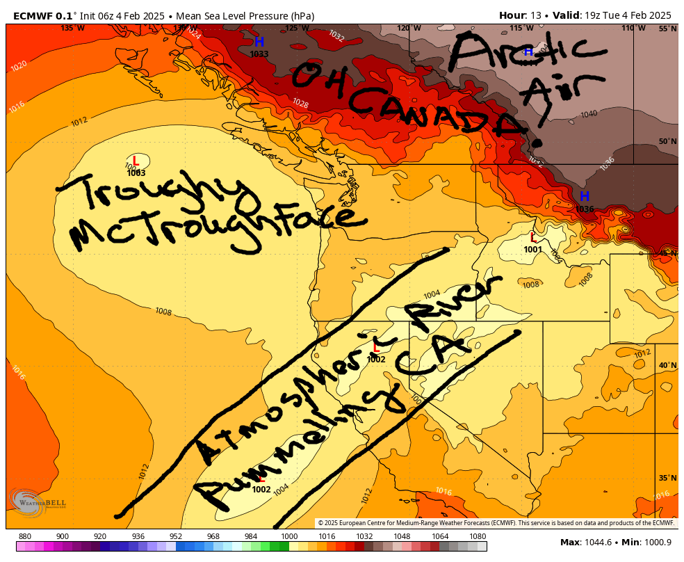
Our attention then turns to next week. Troughy McTroughFace continues to spin offshore, and that keeps us cold and moist. Models are showing increasing signs of significant moisture sometime next week. If that forecast holds, we’re in for a “fun” time here in the Gorge. I mean, the Gorge is always fun, but it gets real sporty when cold air encounters an atmospheric river. Stay tuned to see if this comes to pass. If it comes to pass, it too shall eventually pass. Safe travels. -TATAS
HEY! DON’T STOP READING! Is this community-focused forecast helpful to you? It sure is! It takes me a couple hours a day to write. Please join your friends and neighbors in contributing to keep it going. Venmo: @thegorgeismygym PayPal: twomirrors@gmail.com USPS: Temira / PO Box 841 / Hood River, Oregon 97031 You can test out the forecast subscription for a few days for free by clicking this link: https://subscribepage.io/YhevGc
