

MT HOOD WEATHER FORECAST
Hey skiers and snowboarders! We’ve got good news and bad news to start today. Good news: yesterday’s wacky weather only dropped 0.2” rain on the slopes of Mt. Hood. Bad news is that temps dropped below freezing last night, so it’ll be hard and fast to start the day. Good news: if it softens up, it should be mostly transitioned towards corn snow. Mt Hood weather for the next few days has periods of snow and periods of mixed precip or rain, and then snow returns for the first week of April. I’ll be gone the entire month on a silent meditation retreat, and I’ll return to forecast for you starting early May. Wish me luck!
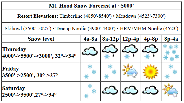
thursday’s mt hood weather forecast
Today (Thursday) kicks off cloudy on Mt. Hood, but it looks like the sun is trying to break through. Models keep the mountain in the clouds today with a bit of mixed precip. That should switch to snow overnight. The snow level will be around 4000′ this morning, 5500-6000′ this afternoon, and back down to 3000′ overnight. Temps at 5000′ will be around 32F this morning, 34F this afternoon, and 30F overnight. Models do tend to overestimate precipitation when instability is present, and that’s the case today. As of right now, they have 0.3” water equivalent (WE) today as snain/rain/very wet snow. No accumulation. Overnight, they’re calling for 0.4” to 0.5” WE. That’s likely to start as mixed precip and transition to wet snow. Call it 2-3” new. Wind will be SW 25-45 in the morning, S 15-30 in the afternoon, and SW 25-40 overnight.
friday’s mt hood weather forecast
Friday starts with lingering light snow and transitions to sunny weather by afternoon. A few flurries are possible after midnight. The snow level will be 3000′-3500′ all day and will drop to 2000-2500′ overnight. Temps at 5000′ will be around 30F to start the day, 28F in the afternoon, and 26-27F overnight. An inch of new is possible in the morning followed by another inch of new overnight. Wind: SW 25-40 in the morning, SW 15-25 in the afternoon, and W 15 overnight.
weekend mt hood weather forecast
Saturday looks cloudy with scattered flurries. The snow level will be 2000′ in the morning and 3500′ in the afternoon with temps rising from 27F to 34F. Wind: W 15 in the morning, light/variable in the afternoon, and SE 20 overnight. Sunday looks partly high overcast in the morning with snow in the afternoon. Snow level: 5000′ falling to 4000′ with a few inches of new expected overnight. Monday starts partly cloudy, quickly adds snow, and turns stormy and snowy overnight. Beyond that… continued cool weather with light to moderate snowfall expected all the way through the first week of April. See you out on the snow!
Was that helpful? I knew it was! Guess what? All of this crucial work – from your personal wind and snow reports to the invaluable TATAS updates – is made possible by my relentless efforts. Maintaining this labor of love isn’t easy. Each daily forecast takes hours. Website hosting, weather model access, and back-end admin work takes time and money. That’s where you come in.
YOUR CONTRIBUTION MAKES A DIFFERENCE
- SUPPORT ACCURATE, HYPER-LOCAL WEATHER FORECASTING
- ENABLE ACCESS FOR ALL, EVEN THOSE WITH LESS MEANS
- SUPPORT A COOL HUMAN WHO WORKS HARD SO YOU CAN PLAY
Take a moment to click one of the buttons below. Donate $19.99 or more (how much does this forecast enhance your life?) and get the email in your inbox. Whether it’s a renewing subscription (auto-renew) or a one-time donation, every contribution makes a real difference. Help me keep this labor of love alive, so we can all continue playing, commuting, and living in the Gorge with peace of mind and the best weather forecasts possible. Thank you!


Hood River, Oregon 97031


GORGE WIND FORECAST

Hi friends! Best chances of wind in the next five days comes on Sunday (easterlies) and Monday (slight chance of westerlies). Beyond that: I’ll be gone for the month of April, so it’s anyone’s guess! Today (Thursday) kicks off with light west wind. It switches to easterly mid-morning; Stevenson with 10mph and Iwash (Rooster) with 15mph. After 2pm, the wind turns calm. River flow over the last 24 hours was 95-181kcfs, river temp is 46.8F, and high temp forecast is 59F with increasing clouds and rain.
Friday starts calm. As a system moves through, westerlies pick up, but it’s far from an ideal setup. Generally speaking, Stevenson to Doug’s will have 13-16mph. From Avery to Boardman, 19-23mph with a period of slightly stronger wind late morning. Keep in mind that those sensors read high compared to Swell; it’s unlikely to be worth driving out east. High temp: 54F and increasingly sunny. Saturday brings light onshore flow, 10mph or less. High temp: 55F and partly cloudy. Sunday: easterlies at 30mph or so thanks to a low spinning offshore. Monday: the deterministic GFS has strong westerlies in the afternoon, but its dozens of friends in the ensemble suite don’t agree. Beyond that: typical showery, cool spring weather with no sign of much-needed, wind-driving, offshore high pressure through the first week of April. It’ll come eventually, probably as soon as I’m all settled in meditating in Massachusetts!
BARE BONES HOOD RIVER WEATHER FORECAST
Partly cloudy sky this morning, rain midday, a thunderstorm or two maybe this afternoon. Temps start in the low 50s and rise to the upper 50s. Light and variable wind. 94% chance of rainbows. Friday will be rainy early then mostly dry. Temps tart in the mid 40s and rise to the mid 50s. Moderate westerlies. 91% chance of rainbows. Saturday will be mostly dry. Temps start in the upper 30s and rise to the mid 50s. Light westerlies. 16% chance of rainbows.
TEMIRA’S AWESOME TRAVEL ADVISORY SERVICE
HYPERLOCAL WEATHER FORECAST FOR THE COLUMBIA GORGE
THE DALLES, HOOD RIVER, WHITE SALMON, TROUT LAKE, STEVENSON, CASCADE LOCKS, PARKDALE, ODELL, HUSUM, BZ, MILL A, WILLARD, GOLDENDALE, RUFUS, ARLINGTON, boardman

Good morning, neighbors! It’s another nice day in the Gorge, but it starts with disappointment about yesterday’s thunderstorms. I heard just one clap of thunder, and there was no large hail. That’s good for orchardists, but sad for my plan to redecorate my already-totaled car with hail dimples. But then again, I’m glad those of you who care about your cars and didn’t have hail damage. Quieter, damp, cool weather is forecast all the way through the next 10-14 days. I’ll be leaving 4/1 for a month-long silent retreat, which means I’ll be leaving you for the month as well. But it’ll be fun to reconnect when I return, and I’ll almost certainly be way less stressed out and much, much funnier.
glenwood
In the meantime, let’s check in with Glenwood! Our favorite tiny hamlet is 45F this morning with a dewpoint of 36F and 0.06” rain in the last 24 hours. Speaking of rain, somewhere I missed Hood River tipping into a surplus for the water year – it’s currently 0.38” in surplus. And speaking of rain again, did you know Massachusetts, where I’ll be meditating, gets 4” of rain in the month of April? Sad.
thursday’s gorge weather
Back here in the Gorge, models give us a dry start to Thursday followed by rain from late morning on. If those models are correctly, rain will extend all the way to Celilo this morning and Boardman this afternoon. Driving to/from the metro area this afternoon? Expect heavy rain west of Hood River into the evening. Temps rise to the upper 50s today, and we can’t completely rule out a thunderstorm. Wind today will be light westerly then light easterly and light westerly again as Mother Nature tests out all the options and refuses to settle on an answer.
friday and beyond
A rainy start to Friday west of The Dalles gives way to a mostly dry afternoon. Exceptions include continued showery weather in the far western Gorge and continued drizzle in the WA hills and plateaus. Temps rise to the mid 50s. Wind starts calm. It rises to 15mph west of The Dalles and 20-25mph east of The Dalles all the way to Boardman. Dry, cloudy weather with a few scattered instability-driven showers is your forecast for Saturday along with calm wind. Sunday morning will be dry, but Sunday afternoon won’t be. Add in east wind at 30mph. As I mentioned before, cool, showery weather continues on and off for the next 10-14 days. But I’ll be elsewhere and turned inward, so… yeah… Safe travels. -TATAS
HEY! DON’T STOP READING! Is this community-focused forecast helpful to you? It sure is! It takes me a couple hours a day to write. Please join your friends and neighbors in contributing to keep it going. Venmo: @thegorgeismygym PayPal: twomirrors@gmail.com USPS: Temira / PO Box 841 / Hood River, Oregon 97031 You can test out the forecast subscription for a few days for free by signing up below. Easy! Do it!
