

For almost 30 years, Temira (they/them) has been making the most of what the Gorge has to offer: riding river swell on a foil or windsurf board, carving fresh lines through the snow, and cycling all the gravel and pavement and trails. This is Temira’s playground, their gym… their life’s work. That’s why in 2006, Temira took it upon themselves to create the most accurate, hyper-local weather forecasts possible. Inaccurate predictions had left too many fellow adventurers caught off-guard and in harm’s way. Temira was determined to change that. Today, Temira’s forecasts have become an essential resource for thousands of skiers, snowboarders, wind sports enthusiasts and travelers through the Gorge. With their guidance, you can plan ahead, time your sessions perfectly, and stay safer on the water, snow, and trails. But the story doesn’t end there. Temira also authors the TATAS Facebook page – the Gorge’s premier source for microclimate forecasts. When winter storms, extreme heat, or other hazardous conditions (avalanches on SR-14 and I-84, for example!) threaten, this community lifeline becomes a vital resource for locals and visitors alike, helping to keep everyone safe.
The best snow forecast for Mt. Hood.
The best weather forecast. Period.Meet Temira,
your Gorge and Mt. Hood forecaster
Go ahead – support Temira
All of this crucial work – from your personal wind and snow reports to the invaluable TATAS updates – is made possible by Temira’s relentless efforts. But maintaining this labor of love isn’t easy. Each daily forecast can take hours to research and analyze. The website, forecast model subscriptions, and back-end admin work take time and money. That’s where you come in.
Your Subscription Makes a Difference:
✓ Support accurate, hyper-local weather forecasting
✓ Enable access for everyone, even those with less means
✓ Support a cool human who works hard so you can play hard
By becoming a contributing member, you’re not just supporting Temira’s passion project – you’re investing in the safety and well-being of the entire Gorge community. Your financial support ensures these essential forecasts remain accessible to all, free of charge.
So please, take a moment to click one of the buttons below. Donate $19.99 or more (how much does this forecast enhance your life?) and get the email in your inbox. Whether it’s a monthly subscription or a one-time donation, every contribution makes a real difference. Help Temira keep this labor of love alive, so we can all continue playing, commuting, and living in the Gorge with peace of mind and the best weather forecasts possible. Thank you!
Electronic payments not your thing? Temira / PO Box 841 / Hood River, OR 97031


Mt. Hood Snow Forecast
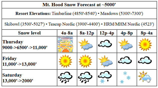
Hi skiers and snowboarders! A couple more days of dry weather are on tap, and then we shift into a couple days of more active weather. Rain on Saturday morning is followed by snow Saturday afternoon into Sunday. We’re probably looking at about half an inch of rain followed by half an foot of snow. Fingers crossed – we’ll want half a foot of snow to refresh the surface after the rain. Models then drag us back into dry weather to start next week. By the end of next week, the temps trend downward and precip trends upward, and we (hopefully) start building our snowpack again!
For Thursday, we’ll have increasing high clouds, but the sky will clear off again late. We could even see a little mist on the slopes this afternoon, but nothing measurable. The free air freezing level will be 9000′ to start, 6500′ in the afternoon, and 11,000′ after midnight. Wind will be W 10 in the morning, SW 10-15 in the afternoon, and variable to 10 overnight. Snow conditions will be mixed on the groom – mostly hardpack with areas of transitioning snow and loose granular in the cold, shady areas. Down at the Nordic zones (at least at Teacup yesterday), the groom is spectacular fast hardpack. Get some!
Friday looks sunny to start and high overcast. It also looks warm: temps start near 40 and rise to 50 before dropping overnight. The free air freezing level will be 11,000′ in the morning and will slowly rise to 12,000′ or more overnight. Wind: variable to 10 early, W 15 in the afternoon, and WSW 30-35 after midnight.
That stronger wind indicates incoming weather. Indeed, a cold front slams into Mt. Hood on Saturday morning and sticks around. A period of heavy rain early is followed by mixed precip in the afternoon and light snow in the evening and overnight. The snow level absolutely plummets: 13,000′ in the morning, 4500′ in the afternoon, and 2000′ after midnight. Most of this moisture is going to fall as rain, but don’t you worry – there is snow forecast Sunday. Anyway, we’ll pick up about 0.5-0.6” rain in the morning followed by 0.2” mixed precip in the afternoon and 0.1” to 0.3” water equivalent of snow overnight. That’s 1-3” snow, probably the lower end. Wind: WSW 30-35 in the morning, WNW 35-40 in the afternoon, and W 30-35 overnight.
Sunday: probably snowy, probably 4-6” snow, probably with the snow level between 2000′ and 3000′. Probably quite windy. A couple of dry days are forecast to start next week, and then we move back into a wetter period, probably rain to start and snow by the weekend, but that’s a bit far out for precision. Let’s leave it there for now. Have a stellar day on the snow!
[DISPLAY_ULTIMATE_SOCIAL_ICONS]Gorge Wind Forecast

Hi friends! Strong easterlies continue today, back off a little tomorrow, and then westerlies of some sort will be present for the weekend. For Thursday, we start with pressures of 30.35/30.52 for a PDX-DLS gradient of 0.17. Easterlies start at 50mph near Iwash (Rooster) Rock and 25mph near Stevenson. Viento: 15 to start. We should see Viento rise to 20 and Stevenson rise to 30 for a couple hours before the wind dips this afternoon. Iwash finishes at 30-35, Stevenson at 15-20, and Viento at 15ish. River flow over the last 24 hours was 72-187kcfs, river temp is 48.2F, and high temp forecast is 39F with increasing high clouds.
Friday starts with 35-40 at Iwash and 20-25 at Stevenson. Stevenson rises to 25 and holds for the rest of the day. Iwash eventually drops to 25-30. High temp: 41F with partly high cloudy sky. Saturday starts with easterlies at 15mph or less. In the afternoon, the wind turns around. Models aren’t super optimistic, but this is a setup that lends itself to over-performing wind. Rain is forecast pretty much all day west of The Dalles. If we’re lucky, we’ll over-perform to 24-27 from Avery to Arlington midday with drizzle and dropping wind at Rufus in the afternoon. Arlington holds into the evening. In the rainy western Gorge, we could see gusty 16-19, but don’t count on it. High temp: upper 40s. But wait! Before you go running out to play in the river, swing by Big Winds for the Locals Appreciation Sale: doors open at 9am on Saturday. Models are all over the place for Sunday. With offshore high pressure in place and rain falling west of Hood River, there should be wind somewhere between Swell and Arlington. We’re going to need to wait a day or two for some model coherence. In the meantime, be safe out there and keep an eye on your friends!
Very basic Hood River weather forecast
Don’t plan your life around this. You really should read Temira’s Awesome Travel Advisory Service on Facebook for a detailed weather forecast.
For Thursday: Nothing. Temps start in the mid 30s and stay there. Light easterlies. 0% chance of rainbows.
Friday will be Nothing. It might lessen a bit in the afternoon, but it’ll still be partially here. Temps start in the mid 30s and stay there. Light easterlies. 0% chance of rainbows.
Saturday will be dry, then drizzly, then pouring. Temps start in the mid 30s and rise to the upper 40s. Light easterlies early. Moderately strong westerlies in the afternoon. 99% chance of rainbows.
Stay Connected with Local Events!
Want to know what’s happening in and around the Gorge? Check out my curated calendar of local outdoorsy events!
Local-ish Outdoorsy Events Calendar
Know of an outdoor-related local-ish event? Let me know! If you don’t tell me, I don’t know about it!
Cycling Update
Right now, as of 12/5, there’s some great riding! It’s frozen up high and good dirt down low. Get it before the rain returns. When it’s wet and muddy, [lease don’t ride, or you’ll do significant trail damage. Then peeps have to fix your mess rather than building new trails. Nobody wants that! Everyone wants new trails. Be a good steward, and pick a different activity
Remember: E-bikes are not allowed on USFS non-moto trails. They are allowed on moto trails.
Make Today Awesome!
Whether you’re shredding fresh powder on Mt. Hood, surfing swell on the Columbia, or just enjoying our stunning home… remember that every day here is a gift. Make the most of it.
Have an absolutely epic day out there!
~ Temira
