

MT HOOD WEATHER FORECAST

Hey skiers and snowboarders! If you like storm skiing weather, today is your day! Mt. Hood should pick we’ll over a foot of snow. Snow continues most of the day Friday into Saturday for another foot of accumulation. A break on Saturday gives way to rain – we’re not sure how much, but it’ll be rain – on Sunday before dry, warm weather kicks off next week. Get up there and get your powder now!
today (thursday)
Thursday’s Mt Hood weather forecast kicks off with a phrase: “storm skiing”. The snow level will be 2500′ this morning, 3000′ this afternoon, and 4000′ overnight with temps at 5000′ in the mid 20s this morning and upper 20s to low 30s overnight. During the day, Mt. Hood picks up up about 0.7” water equivalent (WE) with strong orographic support for perhaps 7-9” new snow. Overnight, another 0.8” WE is forecast with warmer temps and continuing strong wind. Call that 6-9” denser new snow. Wind will be W 40 this morning and WSW 40-45 in the afternoon and night. Free powder refills all day long. Go get yourself some. Also… power is back on at Meadows.
friday
Friday starts with a couple inches of snow, turns dry midday, and picks up more snow overnight. The snow level will be 4000′ in the morning, 3500′ in the afternoon, and down to 1500-2000′ after midnight. Temps at 5000′ will be near 32F in the morning, around 30F in the afternoon, and down to 25F after midnight. About 0.2” WE is forecast early in the morning for a couple inches of dense new snow. Snow returns in the afternoon with 0.2” to 0.4” WE prior to 5pm. Call it 2-4” dense snow. Overnight, about 0.8” WE is in the cards with strong W to WNW wind and cooling temps. Let’s say 8-12” new snow thanks to orographic assistance. Wind will be WSW 40-45 early, SW 25-45 mid-morning, W 35 in the evening, and WNW 35-40 overnight.
saturday
A few flurries early Saturday give way to sunshine for the morning. High clouds arrive in the afternoon, and light snowfall returns overnight. The free air freezing level will be around 1500′ early. It’ll rise to 3000′ in the afternoon. When precip arrives, the snow level rises from 3000′ to around 4500+ after midnight. Temps at 5000′ rise from about 20F in the morning to 29F in the afternoon and 33F after midnight. Just a trace of new snow is forecast overnight. Wind: WNW 35-40 early, W 15 in the afternoon, and SW 15-30 overnight.
extended mt hood weather forecast
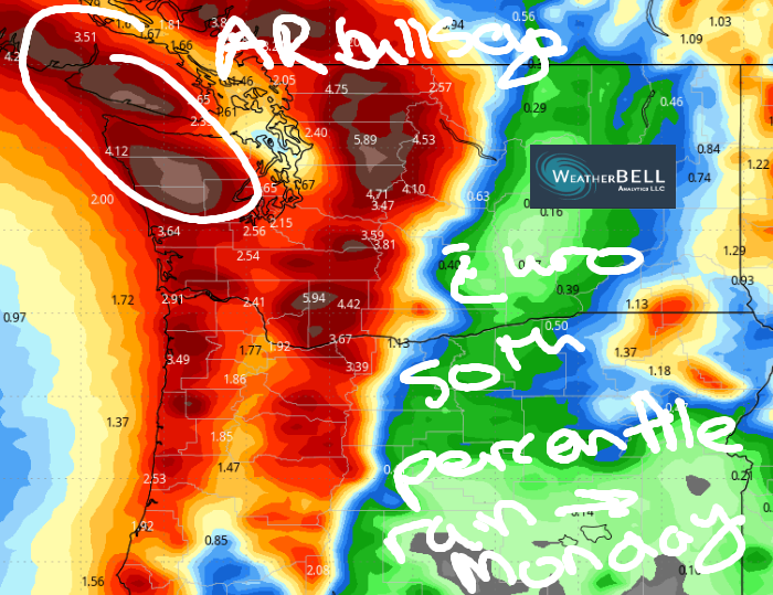
Snow early Sunday quickly switches to rain as a warm atmospheric river focused on the Olympic Peninsula sideswipes Mt. Hood. The exact path is still unclear, which means precip amounts are also uncertain. That said, precip amounts have generally been trending up, and at this point, an inch of precip for the 24 hour period seems reasonable. Don’t be too disheartened; after a few warm days to start next week, we fall right back into a snowy pattern. Have fun out there!
GORGE WIND FORECAST

Hi friends! We have a messy forecast for the next several days. While the wind will be westerly, it’ll be frontally-driven, difficult to pin down, and definitely gusty. Today (Thursday) started with pressures of 30.06/30.04/30.03 for light onshore gradients. Models suggest the wind will pick up to gusty 14-17, maybe a couple mph more, from Stevenson to Swell mid-morning. From Mosier to Doug’s, the wind will be 10-13mph or less for that time period. Between Celilo and Boardman: gusty 19-22mph. After 11am, wind speeds start to fade. River flow over the last 24 hours was 101-156kcfs, river temp is 44.10F, and high temp forecast is 49F with rain all day.
Friday looks similar, although ensembles suggest we could see a slightly stronger day. Around mid-morning, the wind starts to pick up: 14-17 from Stevenson to Swell, less than 10mph from Hood River to Doug’s, and gusty 18-22 out east. The deterministic 4/3k GFS suggests a period of 18-22 from Stevenson to Hood River, maybe to Doug’s, for a few hours in the afternoon ahead of the next weather system. Out east: similar readings on the meter, which means less on the water. After 5pm, rain moves in and pushes all the way east of The Dalles, shutting down the wind (probably). High temp: 52F with atmospheric instability and mostly cloudy sky.
Saturday bring less than 10mph west of Maryhill with upper teens to low 20s to the east. High temp: 53F and mostly cloudy. Sunday: gusty 15-18 with rain likely. Warmer weather is forecast for the first few days of next week, but as of now, models are not optimistic about it being accompanied by enough wind to get on the river. Fingers crossed that changes, because 70 degrees and wind would be awesome! See you on the river!
BARE BONES HOOD RIVER WEATHER FORECAST
Rainy all day into the night. Temps start in the low 40s and rise to the upper 40s. Moderate westerlies. 99% chance of rainbows. Friday will be showery then rainy. Temps start in the low 40s and rise to the low 50s. Light to moderate westerlies. 99% chance of rainbows. Saturday will be mostly dry. Partly cloudy to start. Cloudy later. Temps start in the upper 30s and rise to the low 50s. Light westerlies. 2% chance of rainbows.
TEMIRA’S AWESOME TRAVEL ADVISORY SERVICE
HYPERLOCAL WEATHER FORECAST FOR THE COLUMBIA GORGE
THE DALLES, HOOD RIVER, WHITE SALMON, TROUT LAKE, STEVENSON, CASCADE LOCKS, PARKDALE, ODELL, HUSUM, BZ, MILL A, WILLARD, GOLDENDALE, RUFUS, ARLINGTON, boardman
Good morning, neighbors! Eyes on the prize, folks. Sure, it’s wet out there. Sure there’s lots of rain in the forecast through Sunday night. But we’re still looking at nearly 70 degrees Monday (maybe, now), Tuesday (definitely) and next Wednesday (yep, warm).
glenwood and tatas eootd
Let’s say hi to our friends in Glenwood. “Hi, friends in Glenwood!”. It’s 35 degrees there this morning with a dewpoint of 31 degrees and 0.09” rain so far today. TATAS Executive Order Of The Day: Freshman legislators shall not be sworn in until they have worked on a 10-person team with members of the other party to craft and submit a bipartisan bill. Legislators who refuse to engage in this process shall be replaced by a legislator of the other party after 30 days. You’re welcome.
thursday
Today’s weather: oh, it’ll be wet. Rain extends on and off all the way to the Arlington Triangle. West of Mosier, rain continues into the evening. West of Hood River, rain continues all night. The SW/Sherman County areas will see drizzle this morning and evening for a couple hours each time. If you’re smart, you’ll coordinate your naps with those drizzly hours. Lowland high temps will be in the upper 40s. Snow level: 2000-2500′ early rising to 4000′ later. Wind on the river picks up to 15-20mph all the way from Stevenson to Boardman mid-morning and drops off some in the afternoon.
friday, and today’s mention of a treatable sti
Guess what happens Friday? More rain. Wet weather persists all day west of Wyeth with showers to Hood River. Add in atmospheric instability, and you have afternoon showers everywhere with a chance of small hail and maybe a clap or two of thunder. Which is a lot better than getting the Clap, but fortunately, the Clap is easily treated with antibiotics. Which is one of the reasons we love government-funded science so much! In the evening, heavier rain pushes in all the way past the Tri Cities and soaks even South Wasco, Sherman, and Gilliam Counties. That’s Mother Nature peeing freely because she doesn’t have the Clap. High temp: low 50s. Wind: 15-25mph most of the day all the way from Stevenson to Boardman.
The snow level eventually falls to 1500′ on Friday night as temps at 5000′ drop to -4C. A trace to a couple inches of snow is possible in our highest spots west of a line between Mosier and Appleton.
saturday
Saturday will be partly cloudy with icy roads possible (thanks, radiational cooling) and a few scattered flurries to start. Daytime: dry, yay, and high overcast, okay. Temps rise to the low-mid 50s. Wind: less than 10mph west of The Dalles with 15-25mph east of The Dalles. Drizzle returns overnight.
extended gorge weather forecast
Warmish, wet weather is forecast on Sunday, but the extent of the rain is unclear. The bulk of this atmospheric river pummels the Olympic Peninsula and northern WA Cascades with the same enthusiasm of TATAS pegging someone. Models are increasingly convinced that the Pineapple Express aimed at the USA/CA border will sideswipe us too. Enough about rain! Let’s move on from that to the Monday-Wednesday stretch. Looking at the GFS, we see a sad outcome of Monday only being in the upper 50s. Vote for the Euro, which still has us in the mid 60s Monday. Tuesday makes a run for 70, and Wednesday looks likely to be in the upper 60s. Enjoy it. After that, we’re right back into cool, wet weather that keeps building the mountain snowpack. Safe travels. -TATAS
