

MT HOOD SNOW FORECAST

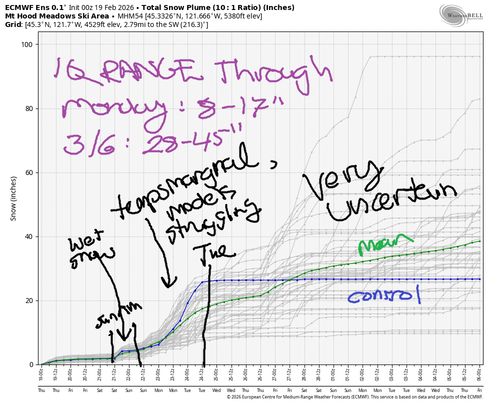
Hey skiers and snowboarders! I was lamenting with my boss this morning that we seem to have broken the planet – it’s been quite warm, and in an interesting twist, the forecast models do not seem to be handling the “new normal” all that well. You may have notice we haven’t been hitting our two-week targets for the intraquartile range. Or maybe you haven’t noticed, but I sure have! Looking into those models… we have light snowfall through Sunday followed by warmer weather with the potential for an atmospheric river sideswipe in the Monday-Tuesday time frame. Models call for 9-17” snow through Monday and 28-45” snow through March 6th.
Short term Mt Hood snow forecast
Looking at Today, Thursday, we have a dry day after a few scattered flurries. The snow level will be around 1000′ this morning, 1500′ this afternoon, and 0′ after midnight. Expect partly cloudy sky during the day and clear sky overnight, which will allow temps to plummet tonight. Daytime temps at 5000′ max out in the low 20s. Wind today will be SE 15-20 this morning, W 15 in the afternoon, and W 20-25 tonight.
Friday will be mostly sunny with some high clouds later. The free air freezing level starts around 0′ with temps in the low teens. By afternoon, the freezing level rises to 1000′ with temp in the mid 20s. Wind will be W 20-25 in the morning, SW 10-15 in the afternoon, and SSE 20 overnight.
Extended Mt Hood Snow Forecast
Saturday looks like another dry day on the slopes with increasing clouds. We can’t rule out a few flurries in the morning or maybe even in the afternoon, but no measurable accumulation is forecast. The free air freezing level will be around 1500′ in the morning and will rise to 5000′ in the afternoon as warmer air slides in from the south. Wind will be SSE 15-20 in the morning, S 15-30 in the afternoon, and S 25-35 overnight.
That southerly flow will be wearing away at the colder air mass on Sunday. We are expecting some light precip during the day and moderate overnight (perhaps 0.6” total water equivalent). At this point, I’m guessing mixed precip or perhaps wet snow with the snow level between 4000-5500′. As we get closer, I’ll have a better idea of what is coming. Wind will be moderate in the SW 25-35 range and will increase overnight. Somewhere along the West Coast late Sunday into Monday, an atmospheric river makes contact. It’s unclear where it will strike and how warm it will be, so I’ll leave it here for now. Have fun up there on the slopes today!
Was that helpful? I knew it was! Guess what? All of this crucial work – from your personal wind and snow reports to the invaluable TATAS updates – is made possible by my relentless efforts. Maintaining this labor of love isn’t easy. Each daily forecast takes hours. Website hosting, weather model access, and back-end admin work takes time and money. That’s where you come in.
YOUR CONTRIBUTION MAKES A DIFFERENCE
- SUPPORT ACCURATE, HYPER-LOCAL WEATHER FORECASTING
- ENABLE ACCESS FOR ALL, EVEN THOSE WITH LESS MEANS
- SUPPORT A COOL HUMAN WHO WORKS HARD SO YOU CAN PLAY
Take a moment to click one of the buttons below. Donate $19.99 or more (how much does this forecast enhance your life?) and get the email in your inbox. Whether it’s a renewing subscription (auto-renew) or a one-time donation, every contribution makes a real difference. Help me keep this labor of love alive, so we can all continue playing, commuting, and living in the Gorge with peace of mind and the best weather forecasts possible. Thank you!


Hood River, Oregon 97031


GORGE WIND FORECAST
If you’re still seeing yesterday’s and it’s after 9am, try opening this in an incognito window
SHORT-TERM gorge wind forecast
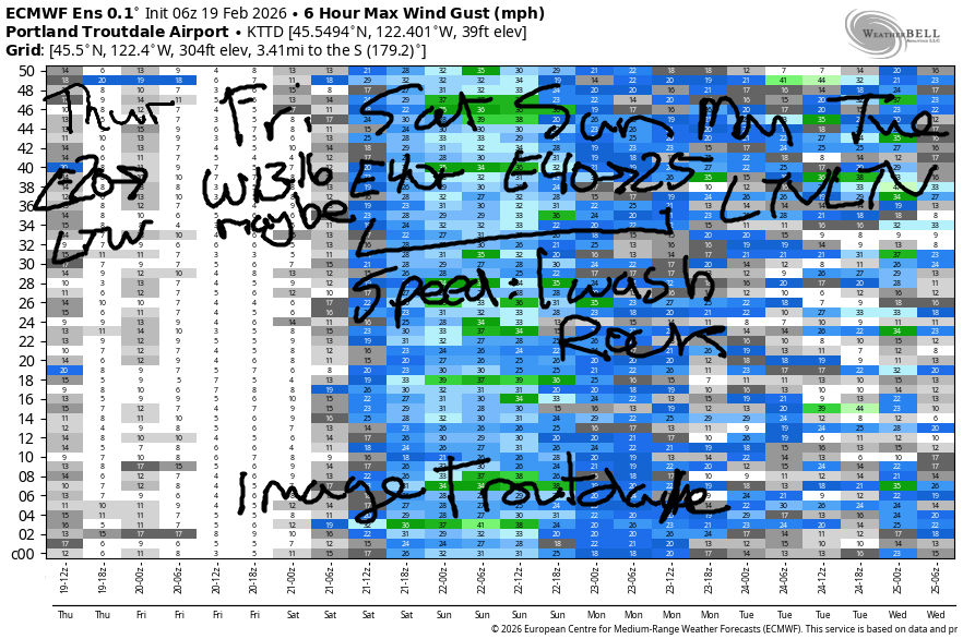
Hi friends! Next best chance to get on the river will be Saturday and Sunday when strong east wind is forecast. In an interesting twist, there’s pretty good agreement in the long-range Euro about the latter half of next week; it suggests offshore high pressure will manifest along with systems moving inland for several days of westerlies. Let’s see if that pans out! In the meantime…
Thursday starts with easterlies under 10mph at Viento and Stevenson with 20mph at Iwash/Rooster. The wind rises to 15mph at Stevenson for a few hours, and then drops off this afternoon. Eventually, after 4pm, the wind turns light westerly. River flow over the last 24 hours was 163-192kcfs, river temp is 41.9F, and high temp forecast is 43F with decreasing clouds.
RIVER FLOW FOR SITES BETWEEN AVERY (EAST OF THE DALLES) AND RUFUS: CLICK HERE FOR JOHN DAY DAM FLOW.
RIVER FLOW FOR SITES BETWEEN STEVENSON AND DOUG’S BEACH (WEST OF THE DALLES): CLICK HERE FOR THE DALLES DAM FLOW

LONGER-TERM gorge wind forecast
Friday starts with west wind at 10-13mph from Viento to the Hatchery. The wind picks up to 13-16mph for a little while, first between Avery and Rufus, then at Stevenson as the eastern Gorge wind fades. By afternoon, most locations will be in the “light” category with Stevenson holding to 10-13mph. High temp: 44F and partly cloudy.
Saturday starts with 40-45mph at Iwash Rock with 35mph at Stevenson. In the afternoon, the wind fades to 35mph at Iwash Rock and 30mph at Stevenson. High temp: 44F under cloudy sky. Sunday starts with easterlies at 40mph at Iwash and fades to 25mph in the afternoon with drizzle in the picture. High temp: 48F. As I said earlier, our attention then turns to next week, Thursday onward, when models hint at the possibility for enough west wind to get you on the river. Cross you fingers this holds, and also cross your fingers for just the right timing!
BARE BONES HOOD RIVER WEATHER FORECAST
Cloudy this morning. Partly cloudy this afternoon. Temp start in the mid 30s and rise to the low 40s. Light easterlies in the morning. Light westerlies late in the day. 4% chance of rainbows. Friday will be partly cloudy. Temps start in the upper 20s and rise to the mid 40s. Light to moderate westerlies becoming light. No rainbows. Saturday will be mostly cloudy. Temps start in the low 30s and rise to the mid 40s. Light to moderate easterlies. No rainbows.
TEMIRA’S AWESOME TRAVEL ADVISORY SERVICE
HYPERLOCAL WEATHER FORECAST FOR THE COLUMBIA GORGE
THE DALLES, HOOD RIVER, WHITE SALMON, TROUT LAKE, STEVENSON, CASCADE LOCKS, PARKDALE, ODELL, HUSUM, BZ, MILL A, WILLARD, GOLDENDALE, RUFUS, ARLINGTON, boardman

Good morning, neighbors! As usual this winter, winter under-performed overnight. I see trace amounts of snow in Underwood and above 1000′ or so, but nothing down in the lowlands despite quite chilly temps aloft. That’s it for snow chances this week. Icy roads: possible the next couple of days. Next thing remotely exciting in the weather: moderate to heavy rain (maybe) in the Sunday-Tuesday time frame as an atmospheric river takes aim at the West Coast somewhere, most likely south of us, but probably sending some rain this way. Next week looks rather unexciting, but the pattern could amplify next weekend. Or not. Results: unclear due to model differences in temp and orientation.
Glenwood and today’s Gorge weather forecast
Looking around the Gorge this morning, we’ve got temps in the 29-38F range with warmest temps in the east wind zone between Troutdale and Viento. Easterlies max out at 20mph this morning before the wind turns calm and then light westerly late in the day, which if you haven’t noticed, has been getting lighter and lighter and lighter. YAY! Clouds break up during the day and leave us with partly cloudy sky and plenty of sun breaks. Yay to that too. Lowland temps climb to +/-43F with the freezing level climbing to 1500′ this afternoon. Do watch out for icy roads today. So far today: no !CE on the roads.
Friday’s Gorge weather forecast
Partly cloudy sky tonight into Friday morning allows temps to cool below freezing throughout the Gorge. If you start with wet roads Thursday night, you’ll have icy roads Friday morning. In the clear sky zones, frost could form on the roads too. We’ll have partly cloudy sky all day long with temps rising to the mid 40s. Wind will be westerly at 10-15mph in the morning and will drop below 10mph in the afternoon. Freezing level in the afternoon: 2000′ or so.
Saturday’s Gorge weather forecast
Upper level flow turns more southerly on Saturday and starts to wear away at our chilly air mass. While we’ll probably start below freezing (30F or so in the lowlands), temps rise to the mid 40s in the afternoon (50 in the desert) with the freezing level climbing above 4000′. Sky will be mostly cloudy, but the only drizzle will be west of Hood River and only prior to noon. Offshore, a low pressure system hangs out. This turns the wind easterly: 40mph at Iwash, 30mph at Stevenson, and 10-15mph through the rest of the Gorge including in the hills.
Extended Gorge weather forecast
We’re likely to end up with some rain on Sunday depending on exactly where the offshore low and associated atmospheric river set up. Snow concerns in the Gorge: zero. Similarly wet, mild weather is forecast on Monday. How mild? Models have the west side at 50F and the Columbia Basin as warm as 57F! We remain under the influence of this pattern into Tuesday. Beyond that: uncertainty rises. Generally speaking, the weather looks 50/50 for rain in the extended. We’re unlikely to have any torrential rain, and we’re even more unlikely to have any lowland hard freezes or snow. Winter remains broken. Safe travels. -TATAS
HEY! DON’T STOP READING! Is this community-focused forecast helpful to you? It sure is! It takes me a couple hours a day to write. Please join your friends and neighbors in contributing to keep it going. Venmo: @thegorgeismygym PayPal: twomirrors@gmail.com USPS: Temira / PO Box 841 / Hood River, Oregon 97031 You can test out the forecast subscription for a few days for free by signing up below. Easy! Do it!
JONES BEACH, SAUVIE ISLAND, & COAST FORECAST
ON WINTER VACATION UNLESS DESPERATELY NEEDED.
