

MT HOOD SNOW FORECAST

Hey skiers and snowboarders! Spring skiing continues for the next week or so as a super-ridge of high pressure maintains its grip over the Pacific Northwest. Slope-side afternoon temps rise to 50+ degrees at 5000′ all the way through at least next Monday, Martin Luther King Jr day. Next chance of snow isn’t until next Wednesday, but in a positive sign, models do call for snow, not rain.
Short term Mt Hood snow forecast
Thursday starts off sunny as can be on the slopes with temps at 50+ degrees all day. It was 52F starting the day at the base of Meadows. Lower elevations (Skibowl, Teacup) were below the inversion and started the day around 31F. That inversion will break some today resulting in random pockets of cold and warm air. Going up to play in the snow? Expect varying snow conditions: hardpack in shady areas or below the inversion or in the trees, and transitioning/granular snow in the sunnier, warmer areas. You’ll even find some slush! Wax universal or red. The free air freezing level today will be above 10,000′. Wind will be E 10-15 this morning, E 15-20 this afternoon, and SE 10-15 overnight.
Friday will be sunny. The free air freezing level stays above 10,000′ all day with temps rising to somewhere between 40F and 55F depending on your exact locations. Once again, clear sky overnight will allow the snow to refreeze thanks to radiational cooling. Wind: SE 10-15 all day.
Extended Mt Hood Snow Forecast
Nothing changes between Friday and Saturday. Mt Hood sees another day of sunshine with high temps in the low 50s. Snow surface: more and more granular; less and less hardpack, hard and fast to start the day and slushy in the sunny areas later. Wind will be SE 15 in the morning, W 10 in the afternoon, and light NW overnight. Sunday also looks sunny, 50F, and warm, with temps rising to the upper 40s and the free air freezing level above 10,000′.
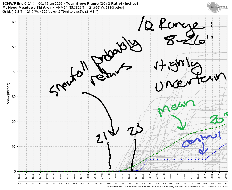
Ditto Monday…. we’ll finally break out of this pattern sometime in the middle or latter part of next week. Not all the ensemble member bring precipitation, but none bring rain. What precip we do get should be snow. By the 29th of January, we have the intraquartile range at 8-26” total snowfall. That’s the 25th percentile snowfall through 75th percentile snowfall. It’s not a ton, but it’s better than nothing, and we’ll take what we can get. Enjoy the sunny slopes the next week or so!
Was that helpful? I knew it was! Guess what? All of this crucial work – from your personal wind and snow reports to the invaluable TATAS updates – is made possible by my relentless efforts. Maintaining this labor of love isn’t easy. Each daily forecast takes hours. Website hosting, weather model access, and back-end admin work takes time and money. That’s where you come in.
YOUR CONTRIBUTION MAKES A DIFFERENCE
- SUPPORT ACCURATE, HYPER-LOCAL WEATHER FORECASTING
- ENABLE ACCESS FOR ALL, EVEN THOSE WITH LESS MEANS
- SUPPORT A COOL HUMAN WHO WORKS HARD SO YOU CAN PLAY
Take a moment to click one of the buttons below. Donate $19.99 or more (how much does this forecast enhance your life?) and get the email in your inbox. Whether it’s a renewing subscription (auto-renew) or a one-time donation, every contribution makes a real difference. Help me keep this labor of love alive, so we can all continue playing, commuting, and living in the Gorge with peace of mind and the best weather forecasts possible. Thank you!


Hood River, Oregon 97031


GORGE WIND FORECAST
If you’re still seeing yesterday’s and it’s after 9am, try opening this in an incognito window
SHORT-TERM gorge wind forecast
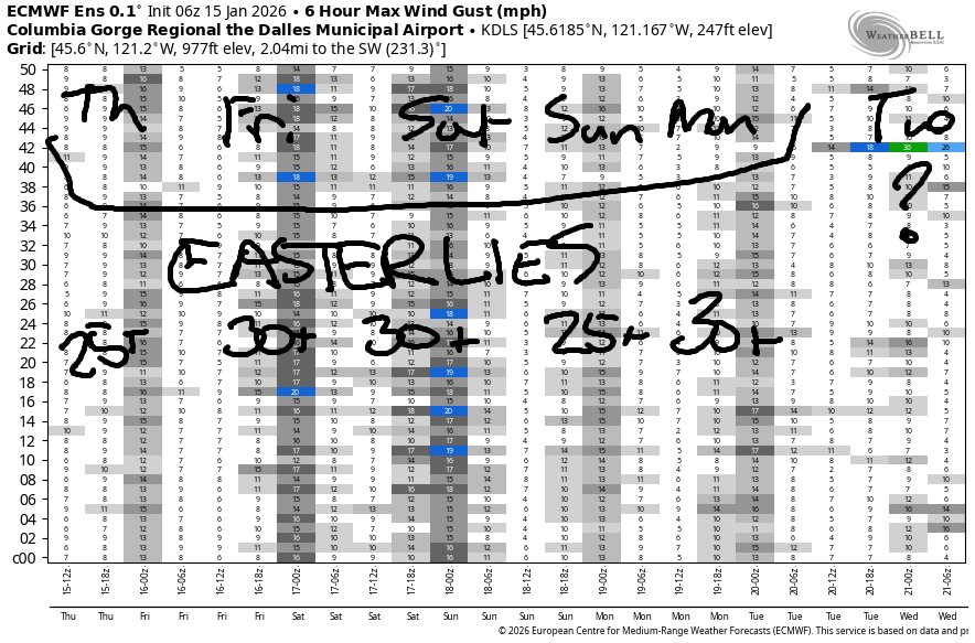
Hi friends! Those of you who like east wind are going to like this forecast a lot. Four of the next five days have strong to very strong easterlies in the forecast. Driving this wind is high pressure and cool air in the desert combined with warm temps and a heat low on the west side thanks to very warm air aloft.
Thursday started with pressures of 30.46/30.54/30.56. Easterlies prior to dawn were reading (thanks, iWindsurf/iKitesurf) 28mph at Iwash (Rooster) Rock, 25mph at Stevenson, and 23mph at Viento. Easterlies hold at Stevenson at 25-30mph all day and slowly build to 40-45mph at Iwash. I should mention that the deepening cold pool could cause the cold air to spill over the Cascades. If this happens, easterlies will under-perform a bit. River flow over the last 24 hours was 178-215kcfs, river temp is 43F, and high temp forecast is 46F with Nothing in Hood River and sun in the east wind zones.
RIVER FLOW FOR SITES BETWEEN AVERY (EAST OF THE DALLES) AND RUFUS: CLICK HERE FOR JOHN DAY DAM FLOW.
RIVER FLOW FOR SITES BETWEEN STEVENSON AND DOUG’S BEACH (WEST OF THE DALLES): CLICK HERE FOR THE DALLES DAM FLOW

LONGER-TERM gorge wind forecast
Friday brings a similar setup with a somewhat colder, denser, higher-pressure cold pool in the desert. If the easterlies stay below the Cascade Crest (and they’ll probably spill over some), we’ll see morning easterlies at 35-40mph at Stevenson and 50mph at Iwash with 20-25mph at Viento. Easterlies drop to 30-35mph at Stevenson in the afternoon but basically hold elsewhere. High temp: 45F with Nothing to the east and sun to the west.
Saturday looks similar: Iwash starts at 50mph and drops to 40mph. Stevenson starts with 35-40mph and drops to 25-30mph. Viento starts at 25mph and drops to 20mph. High temp: 44F with, you got it, Nothing to the east and sun to the west. Sunday sees the easterlies drop to 25-30mph. They’ll build again for Martin Luther King day on Monday. Sometime during the middle or latter half of next week, this pattern will break down. No sign of westerlies in the next couple of weeks. Enjoy the easterlies!
BARE BONES HOOD RIVER WEATHER FORECAST
Nothing is here. It partially burns off later. Temps start in the mid 30s and rise to the mid 40s. Light easterlies. No rainbows. Exactly the same weather is forecast for the next several days! Head to the mountains for sunshine and 50 degrees.
TEMIRA’S AWESOME TRAVEL ADVISORY SERVICE
HYPERLOCAL WEATHER FORECAST FOR THE COLUMBIA GORGE
THE DALLES, HOOD RIVER, WHITE SALMON, TROUT LAKE, STEVENSON, CASCADE LOCKS, PARKDALE, ODELL, HUSUM, BZ, MILL A, WILLARD, GOLDENDALE, RUFUS, ARLINGTON, boardman
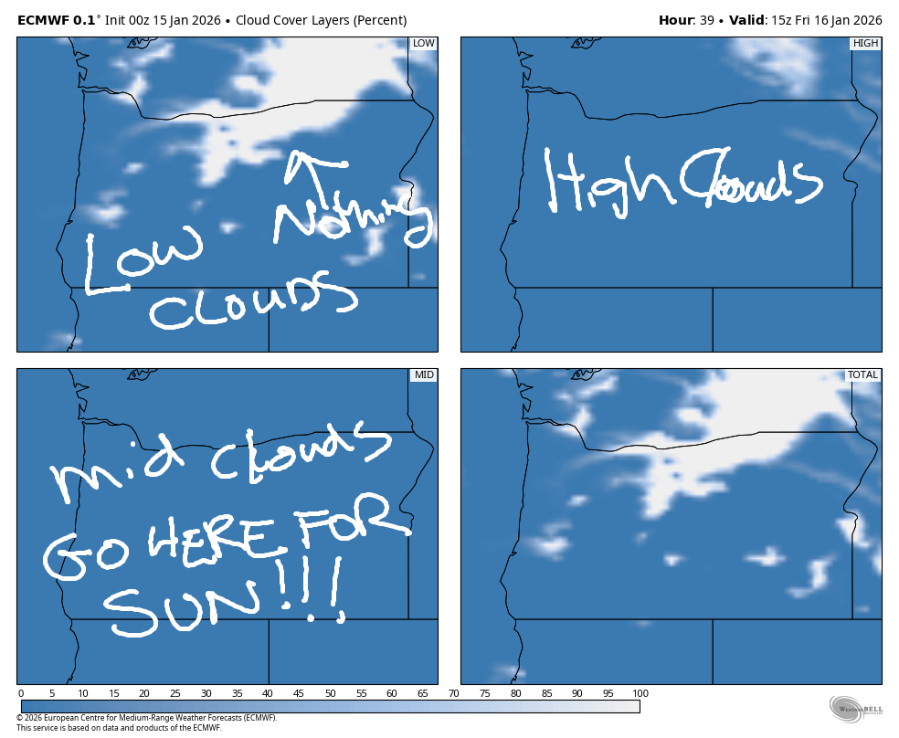
Good morning, neighbors! Your best friend The Nothing arrived early this morning with the cool pre-dawn temps. Make best friends with it, because it’ll be around for at least the mornings while we’re under the influence of this dry, high-pressure ridge. Change arrives in a TBD window about a week from now. In the meantime… cool down low and sunny and warm in the mountains.
Glenwood this morning
Glenwood is doing The Right Thing (for Glenwood, anyway) this morning – it’s 23 degrees there, colder than any other location in the Gorge. Contrast that with 52F at Mt. Hood Meadows and 31F on Middle Mountain, which allows us to guess at both the depth of the inversion and where we can go to escape the clouds. It is sunny above the Nothing!
With strong east wind forecast today (and for the next 4-5 days), you’ll be able to head west or up to find sunshine. Don’t try east – the Columbia basin will be cool and foggy. Speaking of, expect frosty, slick roads and freezing fog in the Nothing zone and potentially above it early in the morning thanks to radiational cooling. Roads yesterday morning were scary – ODOT neglected to de-ice Highway 35 early, and it was frosty and slick from low elevations. Not sure about today. The other kind of ¡CE has not been seen today – most of that kind is currently in Minnesota where the populace is resisting by blowing whistles. You can pick up a whistle kit from Hood River Latino Network.
Back to the details of the weather… a beast of a high pressure ridge offshore is sending the jet stream north to Alaska. Alaska, by the way, has picked up several feet of snow over the last week. Here: no snow. No rain.
The forecast is the same day after day after day
As a matter of fact, we can basically have one forecast for Thursday through at least Monday, MLK day: low temps near the river will be a little colder each day – mid 30s on Thursday and lower 30s from Friday on. High temps theoretically reach the mid 40s each day, but if the Nothing doesn’t break, we’ll see 40F-ish daily. Every day brings freezing fog and slick roads in the Nothing zone. Each day brings a little less chance the Nothing will dissipate, and the farther east you go, the higher the chance that the Nothing will linger 24/7.
Every day brings strong east wind – 30-50mph – near Iwash (it’s NOT a rooster) Rock and 25-35mph near Stevenson. Up in the hills, easterlies will be 10-20mph for the next few days, but the foothill westerlies will fade by Saturday afternoon.
If you prefer your weather sunny and unseasonably warm, get above the Nothing. The easiest way to do this is to go hang out at the lodge at Meadows. They’re perfectly happy to host you and your remote work setup if you’re lucky enough to have that kind of job. Up there, it’ll be 50 degrees or more and sunny all the way through at least the beginning of next week.
You may be wondering what will happen when this pattern fades away. I too am wondering. Details are lacking for now. A massive snow or ice storm is highly unlikely given the marginal temps. It’s okay to set aside that worry. Safe travels. -TATAS
HEY! DON’T STOP READING! Is this community-focused forecast helpful to you? It sure is! It takes me a couple hours a day to write. Please join your friends and neighbors in contributing to keep it going. Venmo: @thegorgeismygym PayPal: twomirrors@gmail.com USPS: Temira / PO Box 841 / Hood River, Oregon 97031 You can test out the forecast subscription for a few days for free by signing up below. Easy! Do it!
JONES BEACH, SAUVIE ISLAND, & COAST FORECAST
ON WINTER VACATION UNLESS DESPERATELY NEEDED.
