

MT HOOD SNOW FORECAST

Hey skiers and snowboarders! It’s Thursday. In the last 24 hours, Timberline picked up 20” of new snow, and Meadows received 15” of new snow. It’s currently mixed precip at the base areas and rain in the Nordic areas. UPDATE: it was raining in he Nordic areas, but cams now show snow! Temps drop this morning and bring another round of massive snowfall before we switch to mixed precip tonight and rain, then mixed precip, then snow on Friday.
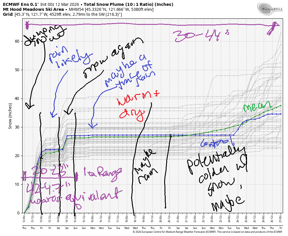
Wind may affect lift operations through early Saturday. Looking deeper into the future, we have warm to very warm weather on the slopes next week. Models disagree about the possibility of precip one day in the middle of next week – for the most part, we’re looking at dry weather. Intraquartile range for snowfall through Saturday morning is 20-23”. Through March 27th, it’s 30-44”.
Short term Mt Hood snow forecast
Thursday’s going to be a very stormy one. Expect lift issues due to icing and wind. The snow level starts around 5500′ and plummets to 2000′ mid-morning before rising to 6000′ this evening. During the day, we’re expecting 1.7” water equivalent (WE) for 10-15” new snow. Overnight, another 1.3” WE is forecast. With temps at 5000′ hovering around +2C to +3C (33-35F), this is probably going to be rain at 5000′ with snow higher. Call it 5-8” at T-Line base and a trace at Meadows base. Wind today will be W 50 early, WSW 50-55 all day, and W 55 all night. This is going to impact lifts, snow quality, and will contribute to avalanche hazards, currently listed as “high” through NWAC. If you’re riding in the resorts, carry your avy gear, keep an eye on others, and stay away from any developing tree wells.
As of the latest model runs, it looks like the atmospheric river will move far enough north on Friday that temps will rise too high for snow at 5000′ on Mt. Hood. 50-100 miles of change could make a huge difference, so please do vote for a more southerly track. As of this morning, the snow level Friday will be 6000-6500′ early, 5500′ in the afternoon, 4500′ in the evening, and then down to 1500′ or less after midnight. 1.7” WE is forecast during the day as mixed precip. Way up high, that’s another foot or more of snow. Meadows base will be rain early and mixed precip later. Call it 3-5”. Timberline base: 5-8”.
Extended Mt Hood Snow Forecast
Overnight Friday into SAturday, another 2.0” (!!!) WE is forecast as initially mixed precip then heavy snow with blizzard conditions. Let’s say 16-20” of new for the alpine resorts and 7-10” at the Nordic areas. Wind on Friday will be problematic: W 50-60mph all day, right on the edge for lifts. Overnight, the wind turns to WNW 45 (full-on blizzard conditions).
Saturday starts windy with a few orographic flurries, but it quickly turns clear. The snow/freezing level will be 1500′ all day. Wind will be NW 35 (problematic) early, but will quickly drop to NW 20-25 and then become light/variable overnight. Sunday looks high overcast and warmer with light wind and a chance of a little light rain in the afternoon. Next week starts warm and dry. Uncertainty increases mid-week, so I’ll leave this here for now. See you on the snow soon!
Was that helpful? I knew it was! Guess what? All of this crucial work – from your personal wind and snow reports to the invaluable TATAS updates – is made possible by my relentless efforts. Maintaining this labor of love isn’t easy. Each daily forecast takes hours. Website hosting, weather model access, and back-end admin work takes time and money. That’s where you come in.
YOUR CONTRIBUTION MAKES A DIFFERENCE
- SUPPORT ACCURATE, HYPER-LOCAL WEATHER FORECASTING
- ENABLE ACCESS FOR ALL, EVEN THOSE WITH LESS MEANS
- SUPPORT A COOL HUMAN WHO WORKS HARD SO YOU CAN PLAY
Take a moment to click one of the buttons below. Donate $19.99 or more (how much does this forecast enhance your life?) and get the email in your inbox. Whether it’s a renewing subscription (auto-renew) or a one-time donation, every contribution makes a real difference. Help me keep this labor of love alive, so we can all continue playing, commuting, and living in the Gorge with peace of mind and the best weather forecasts possible. Thank you!


Hood River, Oregon 97031


GORGE WIND FORECAST
If you’re still seeing yesterday’s and it’s after 9am, try opening this in an incognito window
SHORT-TERM gorge wind forecast
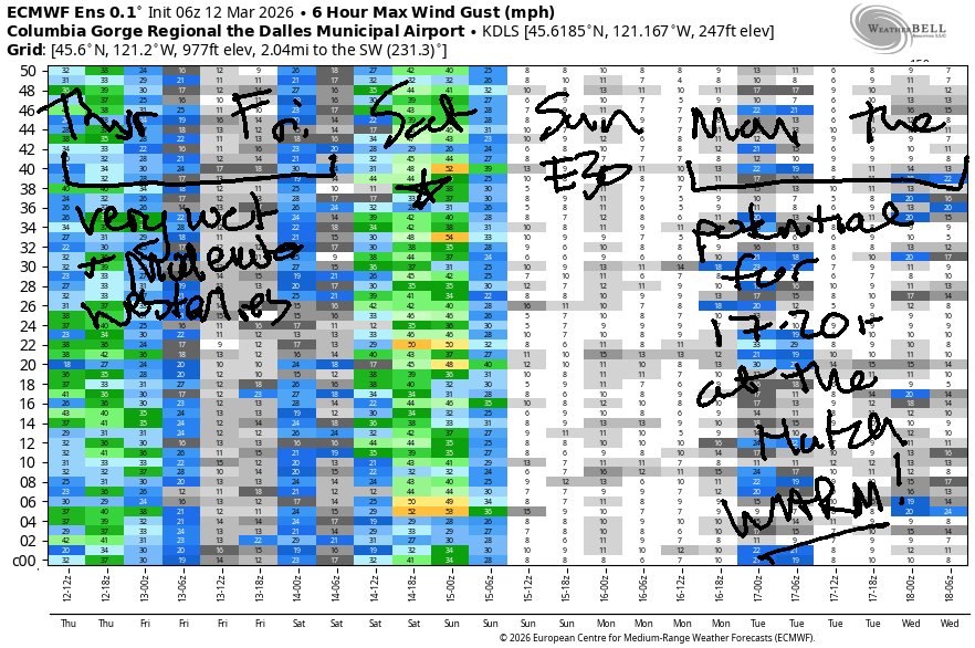
Hi friends! We’re sitting right underneath the jet stream and an associated atmospheric river, and that keeps us in westerlies for the next few days. These may not be the westerlies you were looking for – heavy rain joins up with them. Best chance for dry west wind arrives on Saturday as high pressure builds offshore.
Thursday started with pressures of 30.28/30.16/30.06 for gradients of 0.12/0.10. Areas east of The Dalles were dry and reading 25-28mph to start the day. If you want it, get it right now, because it’s going to drop throughout the morning. By early afternoon, we’ll have 14-17mph all through the Gorge from Stevenson out to Arlington. River flow over the last 24 hours was 179-200kcfs, river temp is 44.4F, and high temp forecast is 50F with pouring rain in Hood River and rain out east after 2pm.
RIVER FLOW FOR SITES BETWEEN AVERY (EAST OF THE DALLES) AND RUFUS: CLICK HERE FOR JOHN DAY DAM FLOW.
RIVER FLOW FOR SITES BETWEEN STEVENSON AND DOUG’S BEACH (WEST OF THE DALLES): CLICK HERE FOR THE DALLES DAM FLOW

LONGER-TERM gorge wind forecast
Friday’s wind stays west of Mosier, and it’s hard to say if it will even make it to the Hatchery. You’ll find gusty 23-26mph at Viento to start the day. Models seem to think the wind will extend to the Hatch, but it’ll be very gusty and combine with pouring rain all day. In the afternoon, we’ll have 18-22mph from Stevenson to The Dalles. East of The Dalles, the wind remains light along the river. High temp: 53F with rain all day long in Hood River.
A cold front whips through Friday night, and high pressure builds offshore Saturday morning. The GFS and Euro do not agree on what will happen; the GFS gives us a moderately strong Hatch day. The Euro insists you’ll be delighted by going to Rufus. Based on pattern recognition, I think either location will work. This forecast could change, but as of right now, I’ll say 23-26 for the Hatch and 28-32 for Rufus. Fingers crossed. High temp: 48F for Hood River with decreasing clouds. Out in the desert: 53F and mostly sunny.
Colder air in he desert combines with warmer air on the coast for easterlies at 30mph on Sunday. Beyond that, our wind situation depends on exactly where a strong high pressure ridge locates. No certainty yet… I’m voting for it to settle in just the right place for Hatch wind. One last thing: tributaries of the Columbia are running quite high right now, and there will be a lot of debris in the river. Please do be careful out there!

BARE BONES HOOD RIVER WEATHER FORECAST
Rain all day Thursday. Temps start near 50 and drop a few degrees later. Moderate westerlies 17% chance of rainbows. Friday will be rainy all day. Temps start in the low 40s and rise to the low 50s. Moderate westerlies. 17% chance of rainbows. Saturday will rainy in the wee hours then dry and partly cloudy. Temps start in the upper 30s and rise to the upper 40s. Moderately strong westerlies early becoming moderate later. No rainbows.
TEMIRA’S AWESOME TRAVEL ADVISORY SERVICE
HYPERLOCAL WEATHER FORECAST FOR THE COLUMBIA GORGE
THE DALLES, HOOD RIVER, WHITE SALMON, TROUT LAKE, STEVENSON, CASCADE LOCKS, PARKDALE, ODELL, HUSUM, BZ, MILL A, WILLARD, GOLDENDALE, RUFUS, ARLINGTON, boardman
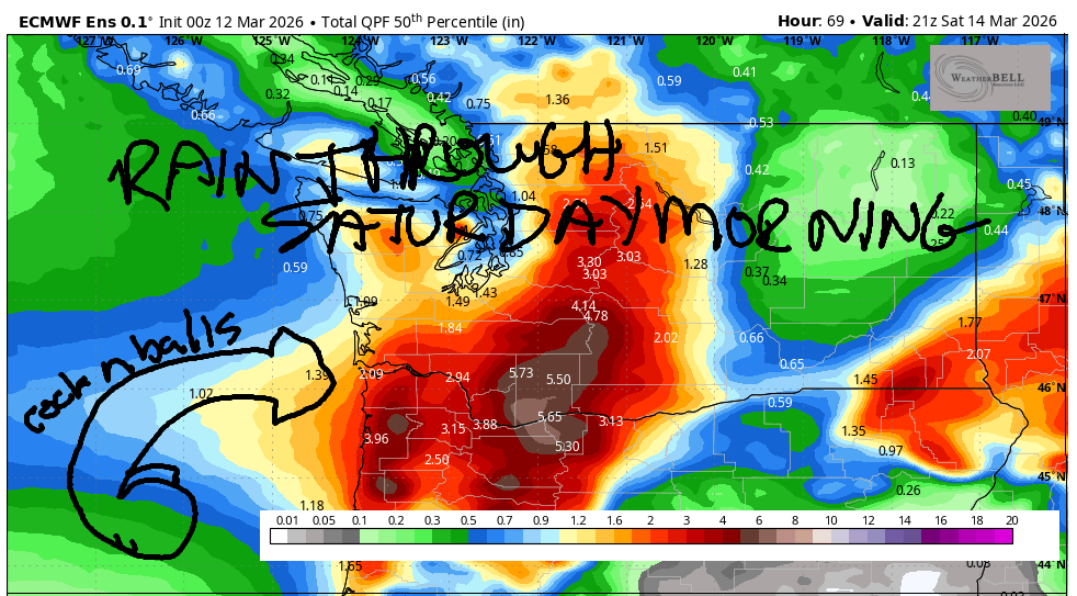
Good morning, neighbors! It sure is dark and gray out there this morning, and it’s wet AF for commuters between here (The Gorge) and there (The City). Don’t let the divide make an enemy of you and the city folk – we’re all in this together! Together we shall be soaking wet for the next 48 hours as an atmospheric river (Pineapple Express) drapes over us. We’ll pick up much-needed snow in the mountains, but we will also see river, creek, and stream rises in the lowlands. Precip wraps up early Saturday morning. Starting Monday, temps leap – we’ll be looking at 65+ for The Dalles!
Glenwood this morning
Up in Glenwood on this gloomy Thursday morning, it’s 43 degrees. Everyone is dusting off their galoshes before they go milk the cows and collect the eggs. Down in the lowlands, commuters are cranking up their windshield wipers. Amazingly, Google Maps shows green all the way through the Gorge to Troutdale. There is no !CE visible on Google Maps nor on the roads in the Gorge.
Today’s Gorge weather forecast
Do prepare yourself for rainy, hydroplaney driving today. We’ll have heavy rain for the western Gorge all day. After a dry morning, areas east of The Dalles add rain this afternoon. Today’s high temps will be 44F (west), 48F (The Dalles), and 56F (The Desert). West wind will be 15-25mph all day, all the way from Stevenson out into the desert.
Friday’s Gorge weather forecast
Pouring rain continues all day Friday west of hood river with light to moderate rain out east and a possible less-wet zone near The Dalles thanks to rain shadowing. After 8am, you’ll find moderate to heavy rain east of The Dalles into the evening. EVERYONE GETS A SOAKING! After a low 40s start, temps rise to the low 50s (west and desert) and upper 50s (The Dalles, where sunbreaks will help). West wind will be 15-25mph west of The Dalles and light to the east.
Extended Gorge weather forecast
A cold front rips through on Friday night and takes the snow level down to 1500′ or so. We’ll look at the details of this as we get closer. By Saturday morning, the precip will be done. We’re set for a partly cloudy, windy day on Saturday with max temps from 48F-53F. Cool weather sticks around on Sunday as warm air moves into the Valley of Willies (Willamette). Warmer air slides atop us starting Monday and makes for much, much warmer weather – 65F. Warmth sticks around for at least a couple days before model agreement falls apart. Dust off your t-shirts and flip-flops! Safe travels. -TATAS
HEY! DON’T STOP READING! Is this community-focused forecast helpful to you? It sure is! It takes me a couple hours a day to write. Please join your friends and neighbors in contributing to keep it going. Venmo: @thegorgeismygym PayPal: twomirrors@gmail.com USPS: Temira / PO Box 841 / Hood River, Oregon 97031 You can test out the forecast subscription for a few days for free by signing up below. Easy! Do it!
JONES BEACH, SAUVIE ISLAND, & COAST FORECAST
ON WINTER VACATION UNLESS DESPERATELY NEEDED.

Leave a Reply