

MT HOOD SNOW FORECAST

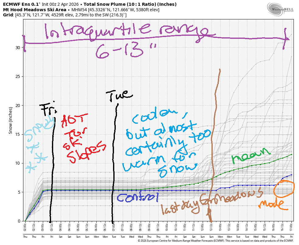
Good morning skiers and snowboarders! The closest thing we’ve had to a powder day in a while is happening today on Mt. Hood. And today’s the best packed pow groom in a while. Get it before it’s gone – by Friday afternoon, temps on the slopes will soar, and the snow will start to transition. For the weekend, we’re looking at very warm temps on Mt Hood – 50+ degrees. Looking deeper into the future, there’s not much hope for snow – temps are forecast to be mild, and there’s not much precip in the forecast either. Intraquartile range for snowfall through the 16th: is 6-13” with most of that coming today.
Short term Mt Hood snow forecast
It is snowing on Mt Hood right now, and the slopes picked up about 6” since yesterday. The snow level will be around 2000-2500′ today with snowfall ending mid to late afternoon. Overnight, the sky turns mostly clear. We’re expecting about 0.3” water equivalent (WE) today, which could be upped by orographic (wind + terrain) assistance. Wind will be NW 40 early, W 40 midday, and WNW 35 this afternoon before dropping to W 15 overnight. Wind that strong is likely to impact the speed of lifts, but most of the below-treeline lifts should be able to run.
Friday brings mostly clear sky all day. The free air freezing level (FAF) will be around 1000′ in the morning, 6500′ in the afternoon, and 7500′ overnight. Temps at 5000′ max out in the low 40s. Wind will be W 15 in the morning, WSW 10 in the afternoon, and light/variable overnight. Get the snow as early as you can, because it’ll turn sticky fast. Surface: hardpack, probably.
Extended Mt Hood Snow Forecast
Saturday will be sunny and warm. The FAF starts at 7500′ and rises to 10,000′ with temps maxing out in the mid 50’s. That’s really something – it should be 55F in the VALLEYS right now, not on the ski slopes. Wax warm. Wind will be light and variable all day turning to S 5-15 overnight. Sunday looks equally sunny, a couple degrees warmer, and will have a few more mph of S wind. Sunshine and warm weather continues on Monday.
Beyond that, models show a high level of uncertainty with a general picture of temps cooling somewhat (but not below freezing) and very little precipitation in the cards. Get it while you can!
Was that helpful? I knew it was! Guess what? All of this crucial work – from your personal wind and snow reports to the invaluable TATAS updates – is made possible by my relentless efforts. Maintaining this labor of love isn’t easy. Each daily forecast takes hours. Website hosting, weather model access, and back-end admin work takes time and money. That’s where you come in.
YOUR CONTRIBUTION MAKES A DIFFERENCE
- SUPPORT ACCURATE, HYPER-LOCAL WEATHER FORECASTING
- ENABLE ACCESS FOR ALL, EVEN THOSE WITH LESS MEANS
- SUPPORT A COOL HUMAN WHO WORKS HARD SO YOU CAN PLAY
Take a moment to click one of the buttons below. Donate $19.99 or more (how much does this forecast enhance your life?) and get the email in your inbox. Whether it’s a renewing subscription (auto-renew) or a one-time donation, every contribution makes a real difference. Help me keep this labor of love alive, so we can all continue playing, commuting, and living in the Gorge with peace of mind and the best weather forecasts possible. Thank you!


Hood River, Oregon 97031


GORGE WIND FORECAST
If you’re still seeing yesterday’s and it’s after 9am, try opening this in an incognito window
SHORT-TERM gorge wind forecast
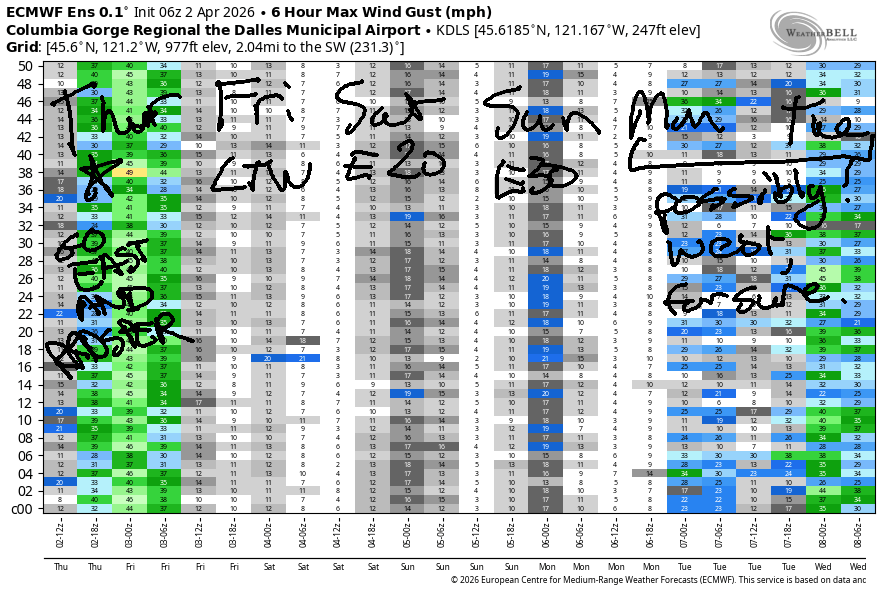
Hi friends! If you like strong westerlies, today is your day! An impulse moves inland mid-morning and sends the westerlies skyrocketing – today’s plan has enough wind that NWS issued a wind advisory for the desert. After today, there’s not much in the forecast until perhaps Monday or Tuesday, with Tuesday being the likely next west wind day. Before I forget… the coast looks windy on Friday and Saturday.
Thursday started with pressures of 29.88/29.80/29.72 for early gradients of .08/.08. That’s solid already, and the action hasn’t even begun! When this system moves inland mid-morning, we’ll see a quick jump to gusty 22-25 from Stevenson to Mosier with 29-33 from Lyle to Rufus or Arlington. By early afternoon, you’ll find 31-35 from Lyle to Arlington with 27-30 from Threemile to Boardman. After 5pm, westerlies drop to 15-18 west of Lyle and 27-31 from Lyle to Hermiston.
Despite predicting wind in the Corridor (near Hood River), the models do keep areas west of Mosier under the low clouds all day. That will result in very up-and-down, gusty conditions. You’ll be best served by doing a bit of driving. River flow over the last 24 hours was 198-242kcfs, and river temp is 47.1F. High temp: 52F for Hood River and 56F out in the desert.
RIVER FLOW FOR SITES BETWEEN AVERY (EAST OF THE DALLES) AND RUFUS: CLICK HERE FOR JOHN DAY DAM FLOW.
RIVER FLOW FOR SITES BETWEEN STEVENSON AND DOUG’S BEACH (WEST OF THE DALLES): CLICK HERE FOR THE DALLES DAM FLOW

LONGER-TERM gorge wind forecast
You may want a rest day tomorrow after partaking in today. You shall get it. The day starts with light westerlies, perhaps 7-10mph, all through the Gorge. Areas east of Mosier turn calm or nearly so mid-morning. Afternoon brings 10-13mph from Stevenson to Hood River. High temp: 62F and sunny.
Saturday sees the wind turn offshore/easterly in response to a heat low on the west side of the Cascades. This gives us easterlies at 20mph at Stevenson and Iwash/Rooster with 15-20mph at Viento. Afternoon wind falls to 15mph. High temp: 69F and sunny. Sunday brings easterlies that max out at 30mph in the morning before fading in the afternoon. Models suggest light westerlies on Monday and potentially stronger westerlies on Tuesday, but we’re too far out to make precision predictions. Have a great time out there today! Wish I could join you, but I committed to meditating!

BARE BONES HOOD RIVER WEATHER FORECAST
Clouds this morning with intermittent sprinkles or drizzle. Partly cloudy this afternoon. Temps start in the low 40s and rise to the low 50s. Moderate westerlies. 99% chance of rainbows. Friday starts mostly clear and stays that way. Temps start in the mid 30s and rise to the low 60s. Light westerlies. No rainbows. Saturday will be mostly clear. Temps start in the upper 30s and rise to the upper 60s. Light easterlies. No rainbows.
TEMIRA’S AWESOME TRAVEL ADVISORY SERVICE
HYPERLOCAL WEATHER FORECAST FOR THE COLUMBIA GORGE
THE DALLES, HOOD RIVER, WHITE SALMON, TROUT LAKE, STEVENSON, CASCADE LOCKS, PARKDALE, ODELL, HUSUM, BZ, MILL A, WILLARD, GOLDENDALE, RUFUS, ARLINGTON, boardman
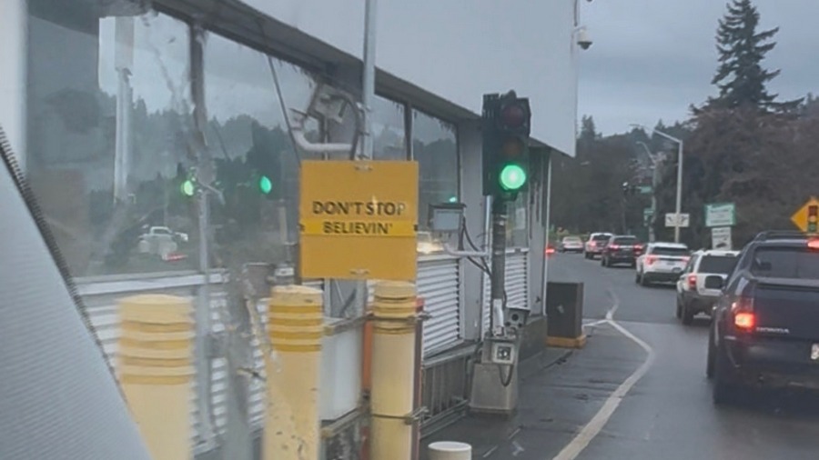
Good morning, neighbors! Did you enjoy the rain yesterday? I did! Did you enjoy April Fool’s Day yesterday? I did! Somebody made my day by making a small, hopeful change to the “DON’T STOP / KEEP MOVING” signs on the Hood River Bridge. As for the forecast… not sure if this is hopeful or not, but we have some 70+ degree sunny weather (SHORT SHORTS!) coming up!
Glenwood this morning
But not today. First, we check in with Glenwood, where everyone is making plans to move to Minnesota to 1) stay cold; 2) protect people from !CE; and 3) eat Hot Dish three meals a day. In Glenwood this morning, it’s 35 degrees. Other chilly spots: 33-36 in Parkdale, 32F on Middle Mountain (WINNING!), and 30-33F in Dufur. Hmm. Must be clear there and not windy…
Today’s Gorge weather forecast
Despite the majority of the clouds dissipating, we won’t warm up a ton today – max temps are 52F to the west, 55F for The Dalles, and 57F out in the desert where a Wind Advisory has been posted by NWS. After 10am or so, westerlies rise to 20-25mph between Stevenson and Mosier and 30-40mph from Lyle to Arlington with 25-30mph east of the Arlington Triangle all the way to Boardman. Know what this is going to cause? A giant exodus of Boardheads from the Hood River area out to Rufus and Arlington. Hooray for them! It’s going to be an EPIC day on the Nch’i Wana!
Friday’s Gorge weather forecast
Overnight, we’re left mostly clear with light west wind and 850mb (~5000′) temps somewhere between -3C and +1C, warming overnight. Dewpoints Friday morning fall to 28-31F in the lowlands and into the low 20s away from the Nch’i Wana (Big River). Frost is likely in the outlying areas: 27-31F in Parkdale and Odell and Trout Lake; 29-32F near The Dalles and Mosier; 22-25F for Glenwood; 26-29F for Centerville and Goldendale. We’ll warm quickly thanks to clear sky and an air mass that approaches +7C at 5000′. Max temps: 62-64F all across the lowlands.
Weekend Gorge weather forecast
Saturday starts mostly clear with light east wind, lower dewpoints, and much warmer air aloft. Temps may dip down to 32F or so in select chilly spots before quickly rising to 68-70F. WARM! SUNNY! MAKE BLOSSOMS HAPPEN AGAIN! East wind picks up to 20mph near Iwash (sorry, no naked sunbathing in this much wind) Rock and Stevenson with light and variable wind elsewhere. Sunday looks very similar but a few degrees warmer with 30mph east wind in the usual east-windy spots. Monday: also warm and sunny with light west wind likely.
Extended Gorge weather forecast
And so it goes… mild, mostly-dry weather is forecast for the next couple of weeks. We’re right on the cusp of all the orchards blooming and giving us right-here-right-now beauty to stare at. Weather wise: So much for April showers! Speaking of April showers, I think I’ll go take one now before I spend the day meditating, half in front of a computer, half while pulling weeds in the garden. Safe travels. -TATAS
HEY! DON’T STOP READING! Is this community-focused forecast helpful to you? It sure is! It takes me a couple hours a day to write. Please join your friends and neighbors in contributing to keep it going. Venmo: @thegorgeismygym PayPal: twomirrors@gmail.com USPS: Temira / PO Box 841 / Hood River, Oregon 97031 You can test out the forecast subscription for a few days for free by signing up below. Easy! Do it!
JONES BEACH, SAUVIE ISLAND, & COAST FORECAST
ON WINTER VACATION UNLESS DESPERATELY NEEDED.

Leave a Reply