

MT HOOD SNOW FORECAST

Hey skiers and snowboarders! This winter is really something else… But at least we have a little bit of new snow on the slopes today. Elevations from 5000′ on up picked up a couple inches of new over the last 24 hours, which will pretty up your photos if not the snowpack. We are expecting a little more snow today before a switch to rain tonight. Next chance for accumulating snow is Sunday into Monday when temps will be a little bit cooler and moisture may be a little more abundant.
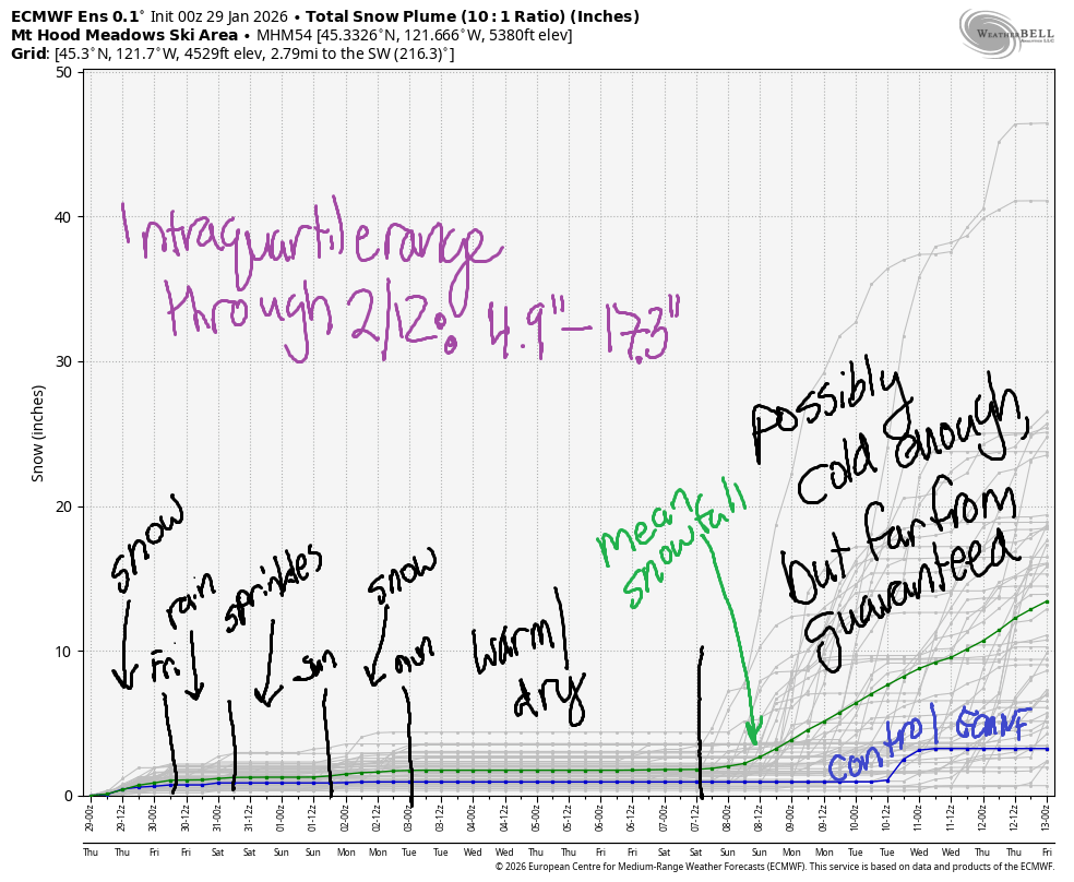
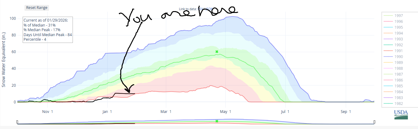
Looking at the rest of next week, we fall right back into a warm-and-dry ridging pattern that will almost certainly last all the way through next weekend. Intraquartile range through Feb 11: 4.9” to 17.3”. Snowpack snow water equivalent: 31% of normal. Percentile: 4th, and very, very close to becoming the driest ever for this date.
Short term Mt Hood snow forecast
Looking at today, we have (thank the stars) snow falling on the slopes. This will transition to drizzle this afternoon, but not much rain is expected. The snow level will be 4000′ this morning, 6000′ this afternoon, and 8500′ after midnight. During the day, we’re expecting about 0.1” water equivalent mixed precipitation for up to an inch of wet new snow if we’re lucky. Overnight, a trace of rain is expected as temps at 5000′ rises to the mid to upper 30s. Wind will be SW 15-30mph all day and all night.
Friday starts cloudy and turns drizzly around 10am. On-and-off drizzle continues into early Saturday morning. The snow level will be around 8500′ in the morning, 8000′ in the afternoon, and 7000′ after midnight. About 0.1” rain is forecast during the day. That’s followed by 0.1” to 0.2” rain overnight. Wind will be SW 15-30 all day and SSW 5-15 overnight.
Extended Mt Hood Snow Forecast
Dry, cloudy weather is forecast all day Saturday. Overnight, very light mixed precip is forecast, perhaps 0.05” WE for a trace of wet snow. The free air freezing level will be7000′ Saturday morning, 8000′ in the afternoon, and the snow level will fall to 5000-5500′ after midnight. Daytime temps max out in the low 40s at 5000. Wind: SSW 5-15 in the morning, SSW 15-25 in the afternoon, and SW 5-15 after midnight.
Models hint at actual snow Sunday night into Monday. As of this morning, there’s too much range to predict how much snow we’ll get. We could see up to 5”, but if that happens, we should consider ourselves very lucky! The snow level should drop down to 4000′ or so, which is good news for the lower-elevation parts of our local ski areas as well as the Nordic locations.
Looking deeper into next week, we have warm, dry weather. Again! After the 10th or 11th, models hint at potentially cooler weather and the potential for some snow, but those models are all over the place on both the snow level and the quantity of possible snowfall. For now, please just cross your fingers! See you on the snow soon!
Was that helpful? I knew it was! Guess what? All of this crucial work – from your personal wind and snow reports to the invaluable TATAS updates – is made possible by my relentless efforts. Maintaining this labor of love isn’t easy. Each daily forecast takes hours. Website hosting, weather model access, and back-end admin work takes time and money. That’s where you come in.
YOUR CONTRIBUTION MAKES A DIFFERENCE
- SUPPORT ACCURATE, HYPER-LOCAL WEATHER FORECASTING
- ENABLE ACCESS FOR ALL, EVEN THOSE WITH LESS MEANS
- SUPPORT A COOL HUMAN WHO WORKS HARD SO YOU CAN PLAY
Take a moment to click one of the buttons below. Donate $19.99 or more (how much does this forecast enhance your life?) and get the email in your inbox. Whether it’s a renewing subscription (auto-renew) or a one-time donation, every contribution makes a real difference. Help me keep this labor of love alive, so we can all continue playing, commuting, and living in the Gorge with peace of mind and the best weather forecasts possible. Thank you!


Hood River, Oregon 97031


GORGE WIND FORECAST
If you’re still seeing yesterday’s and it’s after 9am, try opening this in an incognito window
SHORT-TERM gorge wind forecast
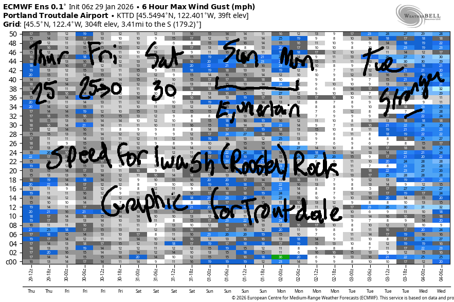
Hi friends! Easterlies… maybe forever! Easterlies remain marginal for most until the middle of next week when models hint at another round of strong east wind. Let’s dive in to the deets, shall we? Thursday starts with wind in the teens at Viento, Stevenson, and Iwash (Rooster) Rock. Peak wind midday rises to 25mph at Stevenson and Iwash before fading to 15-20mph after 1pm. River flow over the last 24 hours was 149-188kcfs, river temp is 40.6F, and high temp forecast is 48F with drizzle.
Friday starts with 25mph at Stevenson and Iwash Rock. After 1pm, the wind goes dead calm all through the Gorge. This is your chance to do those things that are most fun with zero wind! High temp will be 44F with cloudy sky and afternoon sprinkles.
RIVER FLOW FOR SITES BETWEEN AVERY (EAST OF THE DALLES) AND RUFUS: CLICK HERE FOR JOHN DAY DAM FLOW.
RIVER FLOW FOR SITES BETWEEN STEVENSON AND DOUG’S BEACH (WEST OF THE DALLES): CLICK HERE FOR THE DALLES DAM FLOW

LONGER-TERM gorge wind forecast
Saturday looks a bit stronger. Iwash starts the day with 30-35mph and ends the day with 20-25mph. Stevenson’s opening play will be 25mph. After 1pm, Stevenson drops to 15-20mph. High temp forecast is 51F with cloudy sky all day and filtered sun in the afternoon.
On Sunday, the wind looks light enough to simply say “light easterlies”. Same on Monday. Models then hint at (another) ridge building over the Pacific Northwest. The exact location of this ridge will help determine how strong the east wind becomes, but models do have potential for strong (50mph at Iwash) wind starting in the middle part of next week. Stay safe out there – dress extra warmly, have an emergency plan, and keep an eye on your buddies. See you on the Nch’i Wana!
BARE BONES HOOD RIVER WEATHER FORECAST
Light drizzle / sprinkles until late afternoon, a break, and then a little more tonight. Temps start in the mid 30s and rise to the upper 40s. Light easterlies 10% chance of rainbows. Friday will be Cloudy with light rain in the afternoon. Temps star tin the upper 30s and rise to the upper 40s. Light easterlies then calm wind. 9% chance of rainbows. Saturday will be dry during the day and rainy at night. Temps start near 40 and rise to the low 50s. Light easterlies. No rainbows.
TEMIRA’S AWESOME TRAVEL ADVISORY SERVICE
HYPERLOCAL WEATHER FORECAST FOR THE COLUMBIA GORGE
THE DALLES, HOOD RIVER, WHITE SALMON, TROUT LAKE, STEVENSON, CASCADE LOCKS, PARKDALE, ODELL, HUSUM, BZ, MILL A, WILLARD, GOLDENDALE, RUFUS, ARLINGTON, boardman
Good morning, neighbors! IT’S RAINING! This is so exciting! Cars are making rain-related noises as they drive past my house. Objects are wet. The air is moist like an apple pie (you thought I was going to say “moist like a vag*na”, didn’t you?). It’s not just today that’ll be damp – on and off drizzle continues (mostly west of The Dalles) into Monday night. After that: dry and inverted, again.
Glenwood this morning
Our morning foray into local weather includes nothing exciting. Glenwood is 35F to start the day. I couldn’t find anyone below freezing except for that one guy hanging out in the freezer eating Talenti salted caramel gelato at Rosauers. But he was dressed pretty warmly, and none of the staff seemed to care. (I’m making this up, FYI)
Today’s Gorge weather forecast
Weather today has drizzle as far east as Cascade Locks all day with drizzle to the Tri-Cities through mid-morning and drizzle to Rowena through mid-afternoon. Another round of light rain whips through the Gorge early evening for a few hours and wets things as far east as The Dalles. Temps today max out in the upper 40s in the lowlands. East wind builds to 25mph near Stevenson and Iwash (it’s NOT a rooster) Rock before fading to 15-20mph this afternoon.
Friday’s Gorge weather forecast
Clouds stick around all night. We start Friday dry, but rain arrives to Cascade Locks around 10am and sticks around there into the evening. Between 1pm and 4pm, rain intensity picks up in the western Gorge and drizzle extends to Hood River. To the east: dry and cloudy all day. Wind will be E 25mph in the usual spots early. We all go calm in the afternoon. Hopefully that peace extends from the weather into our hearts. High temp in the lowlands: upper 40s.
Extended Gorge weather forecast
Dry, cloudy weather is forecast Saturday. Filtered sun is likely in the afternoon prior to another rainy period overnight. High temp: 50 or so. Snow level: 7000’+. Wind: 30-35mph near Iwash (release the dang files already!) Rock in the morning and 20-25mph in the afternoon. Light drizzle is forecast on Sunday potentially as far east as the Arlington (equilateral) Triangle. Monday: dry during the day with a tiny bit of drizzle overnight. Starting Tuesday, we fall right back into a dry, inverted weather pattern that continues into next weekend.
Winter. Is. Broken. Check out that snowpack image. Safe travels. -TATAS
HEY! DON’T STOP READING! Is this community-focused forecast helpful to you? It sure is! It takes me a couple hours a day to write. Please join your friends and neighbors in contributing to keep it going. Venmo: @thegorgeismygym PayPal: twomirrors@gmail.com USPS: Temira / PO Box 841 / Hood River, Oregon 97031 You can test out the forecast subscription for a few days for free by signing up below. Easy! Do it!
JONES BEACH, SAUVIE ISLAND, & COAST FORECAST
ON WINTER VACATION UNLESS DESPERATELY NEEDED.
