

MT HOOD SNOW FORECAST

Hey skiers and snowboarders! It’s time to break out the Meadows Performance Outerwear (plastic bags) for any mountain-related activities over the next week or so. While there is a short period of snow possible on Saturday afternoon, the vast bulk of the next week’s moisture will be too warm for snow at 5000′. As a matter of fact, 850mb temps (~5000′) aren’t forecast to drop below 0C until perhaps the 12th of December, and even that’s not certain – there’s a ton of uncertainty that far out. How much rain are we talking? 4-7” and potentially more depending on what happens next Tuesday/Wednesday!

Let’s look at the near-term future. It’s Tuesday, and a trace of snow is possible early today. The snow level will be around 3500′ this morning, 4000′ this afternoon, and 3000′ after midnight. Wind: NW 20 this morning, N 10 this afternoon, and light/variable overnight.
Wednesday starts off sunny and turns cloudy. Expect dry weather all day. The free air freezing level (FAF) will be 3000′ in the morning, 5500′ in the afternoon, and 6500′ after midnight. Wind: Light/variable early becoming NW 10-15 in the afternoon and N 15 overnight.
Thursday stats partly cloudy and quickly turns rainy. Snow level: 6500′ in the morning and 9000′ from the afternoon on. A trace of rain is forecast prior to 4pm. After that: 0.7”+ as an atmospheric river gets its fingers into Mt Hood. Wind: N 15 early, W 20 in the afternoon, W 30 in the evening, and WNW 45 after midnight. That stronger WNW wind will intensify rainfall thanks to orographic effects. Pouring rain (3” or so) continues on Friday with the snow level slowly falling from 9000′ to 6500′. Wind: WNW to NW 45 all day and W 35 after midnight.
The snow level drops as low as 4500′ on Saturday afternoon and gives us an inch or two of snow at 5000′. Warmer temps return on Sunday with another round of rain. A break Monday daytime leads to a period of higher uncertainty. It’s possible a much stronger atmospheric river will arrive in the late Monday to Wednesday time frame. Models have about a 50% chance of this happening. Through the middle of next week, the Euro ensemble gives us 4-7” total moisture. Whew… that’s a lot of rain. I’ll leave it here for now with no clear sign of the start of ski season. C’mon, Ma Nature!
Was that helpful? I knew it was! Guess what? All of this crucial work – from your personal wind and snow reports to the invaluable TATAS updates – is made possible by my relentless efforts. Maintaining this labor of love isn’t easy. Each daily forecast takes hours. Website hosting, weather model access, and back-end admin work takes time and money. That’s where you come in.
YOUR CONTRIBUTION MAKES A DIFFERENCE
- SUPPORT ACCURATE, HYPER-LOCAL WEATHER FORECASTING
- ENABLE ACCESS FOR ALL, EVEN THOSE WITH LESS MEANS
- SUPPORT A COOL HUMAN WHO WORKS HARD SO YOU CAN PLAY
Take a moment to click one of the buttons below. Donate $19.99 or more (how much does this forecast enhance your life?) and get the email in your inbox. Whether it’s a renewing subscription (auto-renew) or a one-time donation, every contribution makes a real difference. Help me keep this labor of love alive, so we can all continue playing, commuting, and living in the Gorge with peace of mind and the best weather forecasts possible. Thank you!


Hood River, Oregon 97031


GORGE WIND FORECAST
If you’re still seeing yesterday’s and it’s after 9am, try opening this in an incognito window
today’s gorge wind forecast
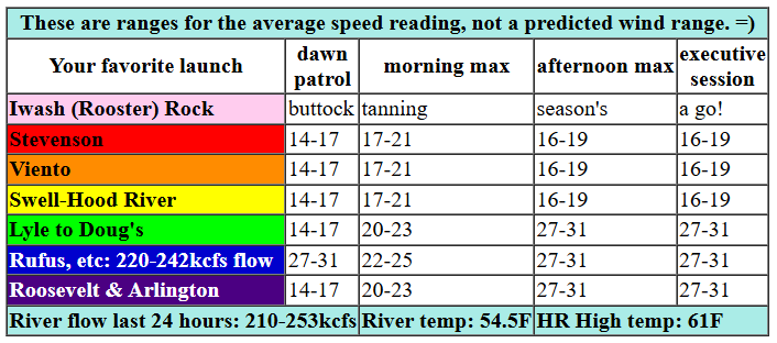
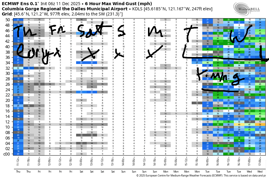
Hi friends! I’m stoked to see y’all got some wind while I was on retreat! Next chance for solid wind arrives in the Monday through Wednesday time period next week. For Thursday, we started with solid westerly gradients – 30.16/30.07/29.99 – but those will back off quickly. Expect early westerlies at 15-18mph at Swell and Stevenson this morning. Viento: 25-28 early and continuing to over-perform bit. In the afternoon, the wind drops to 10-13mph or less as high pressure builds in. River flow over the last 24 hours is 133-156kcfs, river temp is 50.2F, and high temp forecast is 59F. Watch for debris in the river from recent heavy rains.
RIVER FLOW FOR SITES BETWEEN AVERY (EAST OF THE DALLES) AND RUFUS: CLICK HERE FOR JOHN DAY DAM FLOW.
RIVER FLOW FOR SITES BETWEEN STEVENSON AND DOUG’S BEACH (WEST OF THE DALLES): CLICK HERE FOR THE DALLES DAM FLOW

EXTENDED gorge wind forecast
Friday starts calm and turns light westerly. High temp: 60F with sunshine. Saturday brings easterlies at 15mph at both Iwash (Rooster) Rock and Stevenson. High temp: 58F. Sunday: light and variable. Active weather returns in the Monday through Wednesday time period along with the potential for a round of moderately strong to strong westerlies. Once again, we’ll have strong upper-level wind, which is often a good sign for our chances of a Nch’i Wana play day. Fingers crossed!
extended Gorge wind forecast
BARE BONES HOOD RIVER WEATHER FORECAST
Cloudy today with drizzle this morning. Temps start in the mid 50s (record high-low) and rise to the upper 50s. Moderate westerlies early. Light later. 89% chance of rainbows. Friday will be cloudy then clear. Temps start in the upper 40s and rise to 60 or so. Light west wind. No rainbows. Saturday will be partly Noting then mostly clear. Temps start in the low 40s and rise to the upper 50s. Light easterlies. No rainbows.
TEMIRA’S AWESOME TRAVEL ADVISORY SERVICE
HYPERLOCAL WEATHER FORECAST FOR THE COLUMBIA GORGE
THE DALLES, HOOD RIVER, WHITE SALMON, TROUT LAKE, STEVENSON, CASCADE LOCKS, PARKDALE, ODELL, HUSUM, BZ, MILL A, WILLARD, GOLDENDALE, RUFUS, ARLINGTON, boardman
Good morning, neighbors! Pineapple-tinged air lingers in the Gorge this morning – we’re on course to obliterate the record-high low for the date. Hot (for December) weather continues all the way into the start of next week with lowland locations flirting with 55-60 degrees (or more!) every day. Despite the pleasant weather, the roads this morning (it’s Thursday) appear to be free of ¡CE. The roads are also free of ice, snow, sleet, but maybe not mud, rocks, or downed trees. All this rain has certainly loosened up the soil. Snow tires? Mine are still gathering dust.
Looking at Glenwood, it’s just-plain-hot there this morning: 54 degrees. All the lumberjacks are out birling today in anticipation of rain-related log jams in the Nch’i Wana making the Hood River Bridge obsolete. Well, it’s already obsolete, but we’re still using it until we get a new one!
Today’s weather brings intermittent drizzle as far east as Biggs into midday. After that: clouds decrease. The west side is left with low clouds. Out east: partly high overcast sky. Record high temps are in jeopardy today. We’re expecting nearly 60 degrees on the west side and a few degrees more warmth from The Dalles to the east. Seems I’ll be wearing shorts and a t-shirt today. Or maybe nothing at all! Wind will be out of the west at 15mph or so this morning and 10mph or less this afternoon. Also worth noting: MUGGY!!!
Muggy weather continues on Friday (and into the weekend, TBH) as tropically-tinged air sticks around. Despite the mugginess, the day will be dry. After a 50ish degree start, temps rise to an astounding 60 degrees. West side: cloudy to start, clear to finish. East side: just some high clouds filtering the sun. It’s going to be a truly glorious day. Saturday starts off cooler – low 40s – and a bit less muggy. By afternoon, it’ll be sunny and 55-60 degrees. GLORIOUS! Clouds increase on Sunday, but we still top out in the mid to upper 50s.
Another impressive atmospheric river (Pineapple Express) is forecast on Monday as Ma Nature digs deep into a pool of tropically-sourced moisture. Beyond that, models hint at cooler temps. While there’s some uncertainty around the Tuesday-Wednesday time frame (model-to-model differences), the latter half of next week and beyond that looks cooler with continued moisture and at least some chance for a building mountain snowpack. That said, I still don’t see any need to put my snow tires on my car. Yet. But then again, I usually wait until the absolute last possible minute – when the snowflakes are on the horizon, that’s when you’ll find me kneeling in my parking lot questioning my life choices. Safe travels. May your day be free of ¡CE. -TATAS
HEY! DON’T STOP READING! Is this community-focused forecast helpful to you? It sure is! It takes me a couple hours a day to write. Please join your friends and neighbors in contributing to keep it going. Venmo: @thegorgeismygym PayPal: twomirrors@gmail.com USPS: Temira / PO Box 841 / Hood River, Oregon 97031 You can test out the forecast subscription for a few days for free by signing up below. Easy! Do it!
JONES BEACH, SAUVIE ISLAND, & COAST FORECAST
ON WINTER VACATION UNLESS DESPERATELY NEEDED.
