

MT HOOD SNOW FORECAST

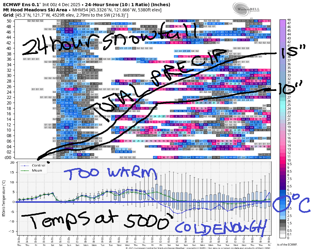
Hey skiers and snowboarders! The amount of moisture forecast in the next couple of weeks – 10-15” – is truly impressive. Most of it’s going to come in too warm for snow, unfortunately. Temps at 850mb (mostly) stay too warm for snow through the first night of Hanukkah (12/14), and beyond that, uncertainty is too high to make an sort of guesses. Just a heads up – I’m going on a meditation retreat starting on 12/5. I’ll be back forecasting on 12/11. My next period of time off isn’t until late April, so I”ll be with you pretty much daily through all of ski season!
Let’s look at the next week. We can sum it up in one word: WET! Thursday kicks off cloudy and quickly turns wet. The snow level starts at 7500′ and rises to 8500′ by the afternoon. About 0.5” rain is forecast during the day. That’s followed by 0.6” rain overnight. Wind: NW 15 in the morning, NW 35-40 in the afternoon and evening.
Friday looks very wet as Mt Hood taps into an atmospheric river (aka the Pineapple Express). The snow level starts at 8500′, rises to 10,000′, and slowly drops to 3500′ overnight. Unfortunately, the vast majority of the moisture will fall prior to temps falling; we’re expecting 2.1” rain during the day followed by 0.1” water equivalent of mixed precip overnight. I’m placing a bet on us getting way more rain than 2.1” given orographic assistance. Wind will be WNW 35 early, W 45-50 during the daylight hours, and WNW 45-50 overnight.
A break in the weather combines with cooler temps on Saturday. The snow level will be around 3500-4000′ all day. It rises to 4500′ overnight. We’re expecting a trace of snow during the day and a couple inches overnight. Wind: WNW 50 in the morning, WNW 303-5 in the afternoon, and WSW 25-30 overnight.
Sunday starts cool enough for snow but quickly turns warm. The snow level will be around 5000′ early, 6500′ midday, 5500′ in the evening, and 3000′ after midnight. Once again, the bulk of the moisture falls as rain: we’re expecting 1.4” water equivalent (WE) during the day. The will be wet snow at the beginning and mixed precip at the end (at 5000′), but accumulation at 5000′ will be negligible. Overnight, an inch or two of snow is possible. Wind: WSW 25-30 early, W 50 midday, W 45 in the evening, and W 25 after midnight. Once again, orographic effects could increase total rainfall.
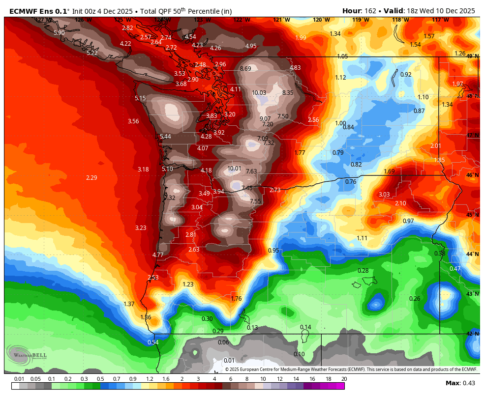
Additional heavy rain is forecast Monday night on through Wednesday. There’s quite a bit of range in the models, but a likely outcome is a strong atmospheric river with many, many inches of rain and very strong wind. Given the saturation of the soils, this could easily take down some trees at the resorts and elsewhere. Goodness. Beyond Wednesday, models uncertainty is vast, and there’s no clear sign of season-opening snowfall due to that uncertainty. We’ll take a look at it again when I’m back from retreat. Y’all take care! Stay dry!
Was that helpful? I knew it was! Guess what? All of this crucial work – from your personal wind and snow reports to the invaluable TATAS updates – is made possible by my relentless efforts. Maintaining this labor of love isn’t easy. Each daily forecast takes hours. Website hosting, weather model access, and back-end admin work takes time and money. That’s where you come in.
YOUR CONTRIBUTION MAKES A DIFFERENCE
- SUPPORT ACCURATE, HYPER-LOCAL WEATHER FORECASTING
- ENABLE ACCESS FOR ALL, EVEN THOSE WITH LESS MEANS
- SUPPORT A COOL HUMAN WHO WORKS HARD SO YOU CAN PLAY
Take a moment to click one of the buttons below. Donate $19.99 or more (how much does this forecast enhance your life?) and get the email in your inbox. Whether it’s a renewing subscription (auto-renew) or a one-time donation, every contribution makes a real difference. Help me keep this labor of love alive, so we can all continue playing, commuting, and living in the Gorge with peace of mind and the best weather forecasts possible. Thank you!


Hood River, Oregon 97031


GORGE WIND FORECAST
If you’re still seeing yesterday’s and it’s after 9am, try opening this in an incognito window
today’s gorge wind forecast
Hi friends! Models have been trending stronger with the Friday-Saturday wind, no surprise given the overall setup and the strong wind aloft. That said, they’ve also been trending later with the wind; it does appear that the strongest wind will happen overnight. Let’s dive in and take a look at the next five days of the Gorge wind forecast, shall we? This is my last forecast until next Thursday – I’m heading out on a retreat, and the housesitter has no skill in forecasting, sadly!
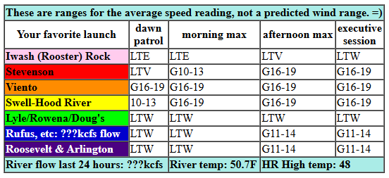
Thursday kicks off with light westerlies except at Viento, where the iWind/iKite sensor is reading 23mph. Seems about right given a weather system is headed this way! We’ll see westerlies pick up to gusty, rainy 17-20mph or so between Stevenson and the Hatch with low to mid 20s possible at Viento. That should hold all day. Not much wind is forecast between Mosier and Doug’s. Between Avery and Boardman, 12-15mph is possible. River flow website isn’t working properly right now, river temp is 50.7F, and high temp forecast is 48F with increasing rain.
RIVER FLOW FOR SITES BETWEEN AVERY (EAST OF THE DALLES) AND RUFUS: CLICK HERE FOR JOHN DAY DAM FLOW.
RIVER FLOW FOR SITES BETWEEN STEVENSON AND DOUG’S BEACH (WEST OF THE DALLES): CLICK HERE FOR THE DALLES DAM FLOW

tomorrow’s gorge wind forecast
A strong westerly system approaches on Friday. Aloft: WNW wind at 45mph, which usually gives us strong/gusty wind between Viento and the Hatch and also between Avery and Rufus. Morning wind will be in the teens and confined to areas west of Mosier. Models hint at very gusty 20-25mph from Stevenson to Doug’s from 1pm on to sunset (probably more at Viento) and gusty 30-35 from Avery to Arlington. After dark, the wind rises to 30-40+ between Stevenson and Arlington. After dark = sad. High temp: 55F and rainy in Hood River with 58F and decreasing clouds east of The Dalles.
extended Gorge wind forecast
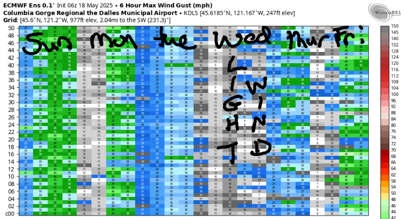
Strong wind is likely early Saturday. Expect a quick fade. Get out there early for gusty 25-28 from Stevenson to Hood River, 17-20 from Mosier to Avery, and 23-26 from Maryhill to Boardman. Afternoon wind fades to 10mph between Stevenson and Rufus and 13-16mph from Philippi Canyon to the Tri Cities. High temp: low to mid 50s with dry weather east of the Hatch. On Sunday, there are no guarantees, but 20mph or so is possible east of The Dalles. Uncertainty climbs to start next week, so I”ll leave it there for now. Oh, one last thing: be on alert for debris in the river – we are expecting a LOT of rainfall. Have fun out there. Get some for me!
BARE BONES HOOD RIVER WEATHER FORECAST
Cloudy sky early. Rain after 10am. Temps start in the mid 30s and rise to the upper 40s. Light to moderate westerlies. 78% chance of rainbows. Friday will be very rainy in the morning then drizzly. Temps start in the low 40s and rise to the mid 50s. Light wind early. Strong westerlies later. 99% chance of rainbows. Saturday will be showery. Temps start in the mid 40s and rise to the low 50s. Strong westerlies early. Light westerlies later. 99% chance of rainbows.
TEMIRA’S AWESOME TRAVEL ADVISORY SERVICE
HYPERLOCAL WEATHER FORECAST FOR THE COLUMBIA GORGE
THE DALLES, HOOD RIVER, WHITE SALMON, TROUT LAKE, STEVENSON, CASCADE LOCKS, PARKDALE, ODELL, HUSUM, BZ, MILL A, WILLARD, GOLDENDALE, RUFUS, ARLINGTON, boardman
Good morning, neighbors! Those of us living along the Cascade Crest and west of it are in line for a soaking over the next week or so. To the east, you’ll be less wet, but periods of rain are scheduled too. As of 7:37am this morning, roads were free of ¡CE, and mostly free of icy spots, but do be careful in those damp, sun-sheltered areas.
Glenwood Thursday morning
Looking at Glenwood this morning, we have 29 degrees and overcast sky. If incoming moisture arrives early enough, Glenwood cold see a tiny trace of freezing rain. Everyone else appears to be above freezing fortunately. Widespread rain arrives by 10am and extends all the way to the Tri-Cities. Expect moderate rain, enough for road lakes, west of Hood River and east of Biggs with steady right rain in the middle zone. Dry weather is forecast east of Hood River tonight except in areas of Sherman and Gilliam Counties, where rain continues. High temps: upper 40s. Wind: 15-20mph out of the west west of Mosier and 10-15mph out of the west east of The Dalles. In the middle: light wind.
Friday’s Gorge weather forecast
Driving to/from the metro area on Friday? I’m sorry. Expect very heavy rain from 4am to 1pm. Lighter rain continues all Friday night. East of Mosier, the weather turns dry and the sky turns partly cloudy late morning. Friday’s big fun is the wind: it starts at a very reasonable 10-15mph. It builds to 30+mph in the evening all the way from Stevenson to Arlington. Even stronger wind is possible especially near Viento and Rufus. With soils saturated, it’s possible we could see some trees come down. Be very careful driving on Friday evening especially in the western Gorge. High temp: 55F (pineapple express temps) with almost 60 F near The Dalles.
Extended and quite wet Gorge weather forecast
Saturday looks dry east of the Cascade Crest with lingering showers over the Cascades and for areas west of Mosier. Wind will be 25-30mph early and 10-15mph in the afternoon. Rainbows are guaranteed near Hood River. Low temp: mid 40s. High temp: 51-55F. Additional rain is forecast Sunday. Monday looks showery until the afternoon, when the heavens open up west of The Dalles. Model uncertainty is high between Monday and Wednesday, but an atmospheric river of some sort is certain. We’re expecting warm, wet weather. The only question is “just how wet will it be?”. Likely answer: drenching. Safe travels. -TATAS
HEY! DON’T STOP READING! Is this community-focused forecast helpful to you? It sure is! It takes me a couple hours a day to write. Please join your friends and neighbors in contributing to keep it going. Venmo: @thegorgeismygym PayPal: twomirrors@gmail.com USPS: Temira / PO Box 841 / Hood River, Oregon 97031 You can test out the forecast subscription for a few days for free by signing up below. Easy! Do it!
JONES BEACH, SAUVIE ISLAND, & COAST FORECAST
ON WINTER VACATION UNLESS DESPERATELY NEEDED.
