MT. HOOD SNOW FORECAST

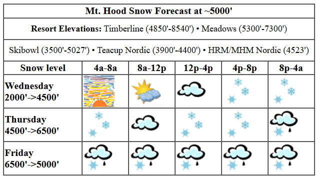
Hi skiers and snowboarders! Mother Nature tossed a curveball at the mountain last night with a period of freezing rain. Definitely some deicing happening out there this morning, but it doesn’t sound extreme. Today’s messiness starts off a couple more days of mixed precip messiness. For those of you eyeing the weekend… there’s at least some snow in the mix. Next week still looks warmer, and most of the ensemble members keep the first few days dry.
Thursday, after an early mixed precip start, should be dry until early afternoon. Snow returns around 4pm. With temps forecast to bounce around between 0C and +2C at 5000′ tonight, we’re probably looking at a mixed precip scenario. For most of the night, we’ll see snow above 6500′, rain in the middle, and freezing rain down low below the inversion. About 0.1” water equivalent (WE) is forecast as snow in the afternoon for an inch of wet new snow. Overnight, we’re expecting 0.4” to 0.5” WE for maybe a couple inches of snow but mostly rain and ice. Wind will be WSW 25 this morning, S 5-10 this afternoon, and it’ll build to S 15-25 overnight.
Liking this forecast?
Friday brings more of that mixed precip for the morning. Snow is forecast in the afternoon and evening. The snow level will be 6500′ in the morning, 4000′ in the afternoon, and 3500′ after midnight. About 0.4” WE is forecast during the day as mixed precip. There won’t be much accumulation out of that. Overnight, another 0.2” WE is forecast as snow for a couple inches of new. Wind: S 15-25 in the morning, SW 25-35 in the afternoon, and W 25 after midnight.
Snow is forecast for Saturday morning. For Saturday night temps will be right on the edge, +1C, for a potential bout of snain or mixed precip. The snow level will be 3000-3500′ during the day, 5000′-5500′ in the evening, and 3500′ after midnight. About 0.1” WE is forecast early for an inch of new. After a short break in the precip midday, another 0.4” WE falls in the afternoon as wet snow (2-3”), probably, and another 0.5” WE lands on the slopes overnight. That overnight precip should also be wet snow: 2-4”. Wind: W 25 in the morning, SW 20-30 in the afternoon, WSW 40-50 in the evening, and W 40 after midnight.
Sunday’s forecast is currently for mostly dry weather with the potential for a bit of orographic snowfall. Given that clouds won’t be all that deep, we could actually see freezing mist instead. Hard to say right now. One thing I can say: Sunday is the Teacup Tea Party! After Sunday, the weather looks mostly dry (80-90% of the ensembles say so) and warmer (well above freezing) for a few days. Let’s leave it there for now. Have a great day on the slopes!
Was that helpful? I knew it was! Guess what? All of this crucial work – from your personal wind and snow reports to the invaluable TATAS updates – is made possible by my relentless efforts. Maintaining this labor of love isn’t easy. Each daily forecast takes hours. Website hosting, weather model access, and back-end admin work takes time and money. That’s where you come in.
YOUR CONTRIBUTION MAKES A DIFFERENCE
- SUPPORT ACCURATE, HYPER-LOCAL WEATHER FORECASTING
- ENABLE ACCESS FOR ALL, EVEN THOSE WITH LESS MEANS
- SUPPORT A COOL HUMAN WHO WORKS HARD SO YOU CAN PLAY
Take a moment to click one of the buttons below. Donate $19.99 or more (how much does this forecast enhance your life?) and get the email in your inbox. Whether it’s a renewing subscription (auto-renew) or a one-time donation, every contribution makes a real difference. Help me keep this labor of love alive, so we can all continue playing, commuting, and living in the Gorge with peace of mind and the best weather forecasts possible. Thank you!


Hood River, Oregon 97031


GORGE WIND FORECAST
Hi friends! Models seem to be coalescing around easterlies for the extended period, but I’m gonna keep dreaming. You should too! For Thursday, we start with 30mph at Iwash and hold there. Stevenson starts with 20ish and rises to 25ish. River flow over the last 24 hours was 110-162kcfs, river temp is 44.78F, and high temp forecast is 39F with rain all day except 1pm-4pm.
Friday brings stronger easterlies and heavier rain. The wind starts with 45mph at Iwash and holds through the morning. In the afternoon, it fades to 25mph. Stevenson starts with 35mph, holds through the morning, and fades to 15mph in the afternoon. High temp: 41F with rain all day. Saturday brings light and variable win. High temp: upper 30s to low 40s (depends on the wind) with rain. Sunday also looks light and variable. Might be a good stretch to join Andy at the boat basin for flat water practice and dock starting!
BARE-BONES HOOD RIVER FORECAST
Clouds and drizzle this morning, dry this afternoon, wet overnight. Temps start in the mid 30s and rise to the upper 30s. Light easterlies. No rainbows.
Friday will be cloudy with rain all day. Temps start in the mid 30s and rise to the upper 30s. Light easterlies. No rainbows.
Saturday will be rainy. Temps start in the mid 30s and rise to the upper 30s. Light easterlies. Then calm. 4% chance of rainbows.
TEMIRA’S AWESOME TRAVEL ADVISORY SERVICE

Good morning, neighbors! Our friends at NWS have finally posted some winter weather advisories for tonight’s messy weather. WYSIWYG, temp-wise, anyway. For some of you, things could stay messy into Saturday. Wet weather sticks around through Saturday. Sunday’s a transition, and then we’re into a dry, Nothing, inversion pattern for at least a few days next week. That’s fine. I have big plans next week, as it’s my birthday week!
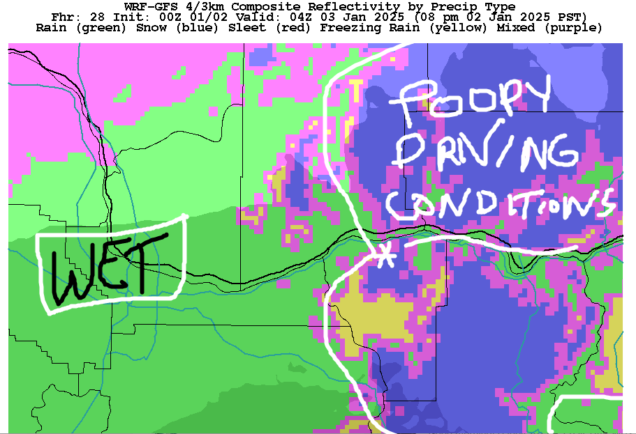
After a few showers this morning, most of us should be dry for a few hours this afternoon. Unless you get in the shower or a hot tub or do some sort of polar bear swim thing. Then you’ll be wet! “Fun” weather begins around sunset with moderate precip to The Dalles, Boardman, and in south Wasco and Sherman counties. This continues all night. Parkdale, York Hill, Hood River Mountain, Middle Mountain, elevated areas of Mosier and The Dalles, Dufur and associated areas, Glenwood, Snowden, Underwood, Trout Lake, Appleton, High Prairie, Centerville, and maybe Goldendale are going to pick up some freezing rain tonight. Temps are borderline, but it should stay just cold enough for a coating of ice. In the lowlands: rain. With widespread east wind forecast, Dufur and other locations along east-facing hills could over-perform in ice accretion tonight. How much will we see? Well, accretion works best at colder temps, and it won’t be super cold, so maybe 1/10”? Maybe 1/4” in the coldest areas? Wind today: E 30 near Iwash and E 25 near Stevenson with easterlies of some sort everywhere else. Max temps today: upper 30s along the river. Wind: E 30 near Iwash (dong) Rock and 20-25mph near Stevenson and Cascade Locks.
Icing (of the weather type, not the cake-coating type) continues into Friday for those special zones. Models suggest that temps will warm up enough to stop the ice by mid-morning Friday, but I’m not convinced. With moderate SW wind aloft, there’s no scrubber in place to remove the cold air. You all might stay icy into Saturday. If you do, you’ll ice it and like it because there’s no point in fighting it. In the lowlands Friday: rain most of the day all the way east to Idaho and also in our southern zones. Exception: 1pm-4pm when the weather dries out for a bit between Mosier and The Dalles. Wind remains easterly: 45mph in the morning near Iwash (dick) Rock and 25mph in the afternoon. High temps in the lowlands will be in the mid to upper 30s.
East of Rowena, you start dry on Saturday. Rainfall rates pick up during the day. Rain can’t-stop-won’t-stop until midnight or so. You’ll find pouring rain west of Hood River between 10am and midnight. Skip the drive if you can. Models suggest ice will continue for some of you until sunset. I wouldn’t be surprised to see the icing continue until the evening when warmer air aloft and strong WSW wind aloft should take all of us above freezing. Remember: scrubber. It’s coming in the form of strong wind aloft. Lowland wind on Saturday will be light and variable. West of Viento, it eventually turns light westerly and warms temps in the mid 40s. The rest of us languish in the 30s.
Sunday looks mostly dry, mostly cloudy, and completely uninteresting. For the first few days of next week, strong high pressure builds in. This gives us warm temps aloft and cool temps with nothing down low. Most ensemble members, say 80-90% keep us all dry for the first few days of next week. That’s enough for now. Safe travels. -TATAS


