MT HOOD SNOW FORECAST

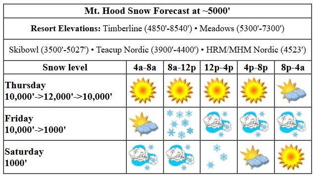
Hey skiers and snowboarders! Sunny, granular-snow weather continues today, and if that’s what you want, you’d better get it. A mountain refresh is on the way tomorrow, and colder weather is in store through next Monday. Generally speaking, the long-term forecast looks pretty dry. If you have carving skis or a carving board, get them ready, and if you’re a skate skier, get ready to set some PRs!
Thursday kicks off sunny, and sunny it stays. Overnight, high clouds start to move in. The free air freezing level will be 10,000′ this morning, 12,000′ this afternoon, and 10,000′ overnight. Wind: SE 10-15 this morning, SW 5-10 this afternoon, and SW 20-35 after midnight.
After a partly cloudy start prior to sunrise, Friday quickly turns snowy and windy. Expect a hard/fast granular start with accumulating new snow after 10am. The snow level will be 10,000′ early, 5000′ when the system arrives, and it’ll slowly fall to 1000-1500′ after midnight. Somewhere between 0.4” and 0.8” water equivalent (WE) is forecast for this 24 hours period, mostly prior to 4pm, for 3-7” new snow. Snow type starts out wet and turns to powder as temps drop – those temps eventually land in the low 20s. Wind will be SW 20-35 to start. It quickly rises to NW 40-45 and holds into the evening. Overnight, it drops to NW 30. NW 40-45 is enough for a near-complete shutdown at Meadows. This time I’m going to watch and see what happens with this direction and strength at Timberline!
Liking this forecast?
Lingering orographic snow flurries are possible on Saturday, and there should also be periods of sun. The snow level will be 1000-1500′ all day with temps in the low 20s at 5000′. Just a trace of snow is forecast. Wind: NW 30 all day dropping to NW 25 overnight. While “NW 30” doesn’t sound terrible, that direction and that speed (as depicted by the sounding model) can have some serious impacts on lifts. Do check the resort websites (Meadows updates way earlier than Timberline) to get a sense of what’s happening.
On Sunday, up to an inch of new snow is forecast under all-day clouds. Clear sky arrives overnight. The snow level will be 1000-1500′ all day. Wind: NW 25 in the morning, NW 20 in the afternoon, and N 10 overnight. Monday looks sunny and cold with light wind. Carving day! Models hint at another sunny warming trend starting Tuesday. Have a great day on the snow today!
Was that helpful? I knew it was! Guess what? All of this crucial work – from your personal wind and snow reports to the invaluable TATAS updates – is made possible by my relentless efforts. Maintaining this labor of love isn’t easy. Each daily forecast takes hours. Website hosting, weather model access, and back-end admin work takes time and money. That’s where you come in.
YOUR CONTRIBUTION MAKES A DIFFERENCE
- SUPPORT ACCURATE, HYPER-LOCAL WEATHER FORECASTING
- ENABLE ACCESS FOR ALL, EVEN THOSE WITH LESS MEANS
- SUPPORT A COOL HUMAN WHO WORKS HARD SO YOU CAN PLAY
Take a moment to click one of the buttons below. Donate $19.99 or more (how much does this forecast enhance your life?) and get the email in your inbox. Whether it’s a renewing subscription (auto-renew) or a one-time donation, every contribution makes a real difference. Help me keep this labor of love alive, so we can all continue playing, commuting, and living in the Gorge with peace of mind and the best weather forecasts possible. Thank you!


Hood River, Oregon 97031


GORGE WIND FORECAST

Hi friends! Fun stuff in the forecast for the next few days. If you’re from elsewhere than the Gorge an can tolerate the cold, come on down fro three days of fun. It starts today, Thursday, with nuking easterlies. Iwash (Rooster) Rock will be 50mph all day. Stevenson hovers in the 30-35 range. Viento will be 25 this morning and 20mph later. River flow over the last 24 hours was 109-167kcfs, river temp is 43.88F, and high temp forecast is 40F with sunshine in the windy zones this morning and filtered sun later.
Friday starts out with light easterlies. A weather system slams in and drops some rain as far east as The Tri Cities in the morning. Westerlies arrive with this system: 24-27 from Stevenson to Mosier, 17-20 from Lyle to Doug’s, and 24-27 from Avery to Rufus by mid-morning. Avery to Rufus rises to 28-32 in the afternoon with a bit less east of Biggs. Areas west of Mosier dip mid-afternoon and surge back late, probably after sunset. Note: the offshore high pressure will be extreme. This favors Swell and Rufus, and Rufus could potentially beat those already-decent numbers. High temp: 46F with partly cloudy sky in the west (after the rain) and sun out east. Saturday sees that weather system clear the area. Strong high pressure lingers offshore. Call it 23-26 from Stevenson to Mosier (probably – depends on the cloud line) with 11-14 in the eastern Gorge. High temp: 44F. Sunday: light westerlies. Have a great day out there on the river!
BARE BONES HOOD RIVER FORECAST
Nothing today. Temps start in the upper 30s and don’t move much. Easterlies. No rainbows. Friday starts Nothing and then turns rainy. Overnight: partly cloudy. Temps start in the mid 30s and rise to the mid 40s. Light easterlies early. Strong westerlies mid-morning on. 99% chance of rainbows. Saturday will be partly cloudy. Temps start in the mid 30s and rise to the mid 40s. Moderately strong westerlies. 1% chance of rainbows.
TEMIRA’S AWESOME TRAVEL ADVISORY SERVICES (TATAS)

Good morning, neighbors! Most of us are below the Nothing this morning, and such will things stay today, sorry. If you have the ability, cozy on up under your blankets, under the Nothing, and read a good book. After a bout of rain tomorrow, many of us will have sun Friday and Saturday and Sunday and Monday. Thanks to a change in the overall weather pattern after today, you’ll want to head east for sunshine starting Friday rather than heading up/west/north in the east-wind setup. Warning: if you head east for sun (and Indian food at Amayah’s), you’ll also find wind, lots of it!
TODAY
Not much happens Thursday unless you head west of Viento or up above the Nothing. In the Nothing, temps are below freezing, and roads are likely to be slick. Interesting features today: 35mph east wind near Stevenson and 50mph east wind near Iwash (dick) Rock, which has shrunk to 12.37% of normal size due to the combo of cold air and strong wind. Up in the mountains, you’ll find full-on sunshine and temps pushing 50 degrees. Remote workers: it’s a great day to head to Meadows to work from the lodge. Catch the CAT bus if you can! Down here: temps won’t crest 40 unless you head to the windy zones, where it’ll be slightly warmer but horribly wind-chilled.
FRIDAY
A weather system smacks down the Gorge on Friday morning like Paul Jones ramming a snow drift with a plow at 2:07am on a clear night. We can’t rule out a quick spurt of freezing rain jizz in the Nothing zones and in the colder zones (Parkdale, Trout Lake, Middle Mountain, Sevenmile Hill, York Hill, Appleton, and High Prairie). That said, very strong WNW aloft starting a bit after sunrise will quickly take all of us above freezing. Want snow? If you’re above 1000′, you can have a few flurries overnight as the snow level drops to 1500′. Back to the daytime weather: that incoming moisture eventually extends all the way east to the Tri-Cities. After noon, it shuts off east of Cascade Locks and leaves us partly cloudy to the west and sunny to the east. High temps in the lowlands rise to the mid 40s. Wind will be easterly at 15mph early, but it’ll quickly switch to westerly at 25-30mph from mid-morning on. 30-35mph isn’t out of the question for areas east of The Dalles. Overnight, mostly clear sky allows all the wet roads to freeze into black ice. Be very careful out there.
SATURDAY AND BEYOND
Saturday will be cloudy in the west, clear out east, and drizzly west of Cascade Locks. After a black-icy start with lots of stars above, we’ll have a blue-sky day with just one star (the closest one) visible. SUNSHINE! Add in west wind at 25mph or so west of The Dalles, and add in high temps in the low to mid 40s for a damned fine winter day. A few snow flurries are possible overnight into Saturday above 500′. Cloudy weather with flurries up high and sprinkles down low is currently forecast for Sunday. Monday: Nothing down low, sun above. Generally speaking, models keep us dry for a while. Remember we had talked about hints of colder weather starting around the 20th? Remember we also talked about regression to the mean? The regression happened – while many of the ensemble members still look cooler in that time frame, not all of them do, and the forecast temps have moderated. Whether you’re happy about that or not, be happy with me, because I got to say the phrase “regression to the mean”. Safe travels. -TATAS
HEY! DON’T STOP READING! Is this community-focused forecast helpful to you? It sure it! It takes me a couple hours a day to write. Please jump in a contribute to keep it going. Venmo: @thegorgeismygym PayPal: twomirrors@gmail.com USPS: Temira / PO Box 841 / Hood River, Oregon 97031 You can test out the forecast subscription for a few days for free by clicking this link: https://subscribepage.io/YhevGc


One response to “Thursday: Mt. Hood gets some sun, some snow, and some wind. Ah, what a forecast!”
Do you sell stickers? If not you should. Love what you effort you put in.