

MT HOOD WEATHER FORECAST
Hey skiers and snowboarders! That was a fun stretch of cold, crisp, sunny Mt. Hood weather, and now it’s time to dive back into the kind of winter that adds to the snowpack. As you’re well aware, that kind of winter will affect the metro area too, so plan accordingly. We’ll see light snowfall the next couple of days followed by heavier snowfall Saturday night into Monday. Models still think we’ll add 18-24” or more to the snowpack by Monday evening. Yay! Snow conditions now: hardpack. Incoming: powder.
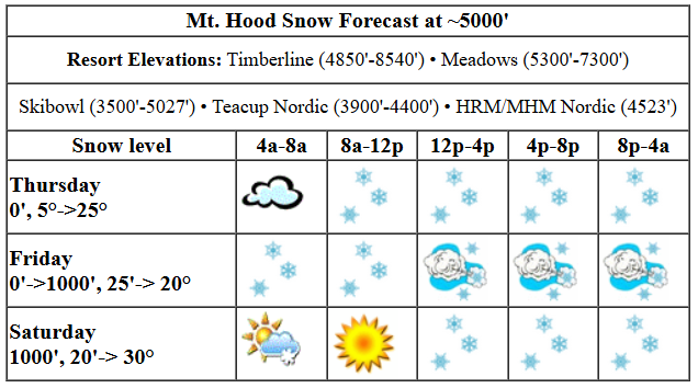
Thursday kicks off high overcast, cold, and dry on the mountain. Snow conditions: hardpack groom and skier-packed powder off the groom. Wax: turquoise was right yesterday. Blue is probably the call today. Alpine folks: cold wax or a mix of cold and extra cold of some sort. The snow level today will be 0′ all day long with temps on the slopes at 5-10 degrees this morning, teens this afternoon, and mid 20s overnight. About 0.1” to 0.2” water equivalent (WE) is forecast during the day for a couple inches of new snow. Overnight, another 0.3” WE is forecast for about 3” more. Wind will be SE 35 this morning (could affect lifts at T-Line), SW 10-20 this afternoon (no problems there), and W 15-20 after midnight.
More snow is forecast on Friday. The snow level will be 0′ in the morning, 1000′ in the afternoon, and 1000-1500′ after midnight. Temps will be near 20F all day. About 0.4” WE is forecast during the day with a lessening of snowfall late morning before a resurgence in the afternoon. I’d say that’s about 4-5” decent powder, but with nuking wind in the cards, we could see 5-7”. Overnight, just a trace is forecast, but with strong NW wind continuing, we could see a few inches. Wind will be problematic. The deterministic GFS has W 15-20 early, NW 40 midday (that’ll shut down Meadows and likely T-Line with problems possible at Skibowl too), W 40 mid-afternoon (might get some lifts back then) and NW 35 for night skiing (again, that’s likely to shut down Meadows due to the direction). That’s Mt. Hood storm skiing for you!
Saturday kicks off clear. Snowfall returns in the afternoon. The snow level per the sounding models will be 500′ in the morning, 1000′ in the afternoon, and 0′ overnight, but temps will be much warmer than that makes it sound: 20F in the morning, upper 20s to 30F in the afternoon, and right around freezing overnight. After a sunny start, snow arrives in the afternoon. Prior to 4pm, just a trace is forecast. Overnight, 0.4” to 0.5” WE of dense snow is in the cards. Call it 3-5”. Wind: NW 25-30 early, SW 10 in the afternoon, SW 20-30 in the evening, and WSW 30-35 overnight.
Heavy snow is forecast Sunday into Monday with over a foot forecast in that 24 hour period. Temps at 5000′ hover in the upper 20s to low 30s. Temps drop a bit on Monday and snow continues. That’s all for now. Have a great day on the snow!
Liking this forecast?
Was that helpful? I knew it was! Guess what? All of this crucial work – from your personal wind and snow reports to the invaluable TATAS updates – is made possible by my relentless efforts. Maintaining this labor of love isn’t easy. Each daily forecast takes hours. Website hosting, weather model access, and back-end admin work takes time and money. That’s where you come in.
YOUR CONTRIBUTION MAKES A DIFFERENCE
- SUPPORT ACCURATE, HYPER-LOCAL WEATHER FORECASTING
- ENABLE ACCESS FOR ALL, EVEN THOSE WITH LESS MEANS
- SUPPORT A COOL HUMAN WHO WORKS HARD SO YOU CAN PLAY
Take a moment to click one of the buttons below. Donate $19.99 or more (how much does this forecast enhance your life?) and get the email in your inbox. Whether it’s a renewing subscription (auto-renew) or a one-time donation, every contribution makes a real difference. Help me keep this labor of love alive, so we can all continue playing, commuting, and living in the Gorge with peace of mind and the best weather forecasts possible. Thank you!


Hood River, Oregon 97031


GORGE WIND FORECAST

Hi friends! Nuking east wind sticks around today. That’s followed by early easterlies on Friday with a darn good shot at enough west wind and warm enough temps to get you on the river. Easterlies return on Saturday and stick around through the weekend. For Thursday, Iwash starts with 55mph and drops to 50mph. Stevenson starts with 30mph and rises to 35mph. Viento: 24mph in case you were wondering. To the east of Viento, most places are reading around 10-15mph out of the east. Overnight, the wind will drop some. River flow over the last 24 hours was 101-142kcfs, river temp is 38.12F, and high temp forecast is 27F with light snowfall. It’s too cold, people! Don’t do it!
Friday kicks off with lingering easterlies: 35mph at Iwash and 20mph at Stevenson. As a low moves inland and a front swings through and high pressure builds offshore, westerlies rise. Call it late morning or early afternoon. There’s a lot of range in how much wind the ensembles think we’ll see, but 20+ sees reasonable at the Hatch with some potential for quite a bit more. This is also a decent setup for Rufus, and models are hinting at mid to upper 20s there. High temp: 35F with snow in the morning, snain showers in the afternoon, and sun east of The Dalles. Saturday kicks off with light westerlies prior to dawn, but then the wind turns calm. Easterlies build in the afternoon and land at 25mph at Iwash and 15mph at Stevenson. High temp: 38F, perhaps with mostly cloudy sky and rain/snain/snow in the afternoon. Stay safe out there, people!
BARE BONES HOOD RIVER WEATHER FORECAST
Clouds this morning give way to light snowfall late morning. 1-3” today. Temps start in the upper teens and rise to the upper 20s. Moderate easterlies. No rainbows. Friday will be snowy with snain/showers possible in the afternoon. Temps start in the low 20s and rise to the mid 30s. Light easterlies early. Moderate to strong westerlies later. 89% chance of rainbows. Saturday will be cloudy then probably snowy but potentially rainy/snainy. Temps start in the upper 20s and rise to the upper 30s. Light westerlies early. Light easterlies later. 19% chance of rainbows.
TEMIRA’S AWESOME TRAVEL ADVISORY SERVICE
HYPERLOCAL COLUMBIA GORGE WEATHER FORECAST
Good morning, neighbors! We’re in the calm before the not-so-stormy storm this morning. With 1-3” of snow forecast for the Gorge today and another 1-3” overnight, we’ll have just enough to make the Gorge pretty again. Wait, just like the USA never stopped being great, the Gorge never stopped being pretty! Snow continues on Friday, and then the picture gets much more complicated for the weekend.
glenwood and the Tatas-eootd
Let’s check in with our 220 friends in Glenwood. Thanks to overnight cloud cover, the temp only dropped to 16F there overnight, which is in line with everyone else’s starting point today. Now, the executive order of the day: The standalone deduction for donations to non-profits will be returned to the 1040 for folks who claim the standard deduction. In other words, folks of lesser incomes will have tax incentives/rewards for their contributions to 501c3 organizations. Signed with gold finger paint.
today
On to this morning’s weather: temps are generally running from 15-20F. Dewpoints are in the 5-10F range, meaning the air is dry and will take some time to saturate. What a waste of moisture… saturating the air and dropping temps thanks to evaporative cooling. Anyway, we are supposed to see light snowfall moving in from the SSW mid-morning. That’ll start first at higher elevations and slowly filter down lower as the air mass saturates enough to STOP SUBLIMATING MY SNOWFLAKES. Models suggest 1-3” of snow during the day today. Heaviest snowfall will be in South Wasco, Parkdale, the Cascade Locks/western Gorge zone, and the Willard zone. Additional snow falls overnight, heaviest west of Hood River and south of the Columbia. To the North: trace to an inch. To the south: 1-3”, heaviest in South Wasco, Parkdale area, and west of Hood River. Temps max out in the upper 20s today. Wind near Iwash will be 50mph all day. Stevenson will be 30-35mph all day. We can’t rule out blizzard conditions in the heaviest snowfall periods in the western Gorge: 10am-1pm today and 1am-7am on Friday.
metro area today
Now, let’s look at the metro area. Cover your eyes and just peek, because it’ll be peak madness with snow falling this morning, freezing rain this afternoon, and potentially a return to snow (at least near Troutdale) overnight. STAY AWAY. STAY FAR AWAY. In the more southern parts of the Valley of Willies (Willamette Valley is too hard to spell and doesn’t carry cock connotations), ice will be more prominent than snow.
friday
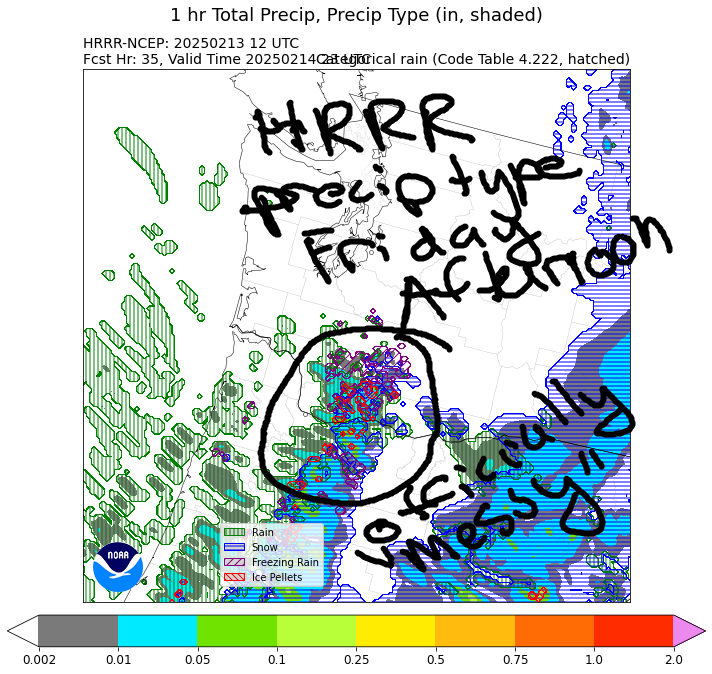
Back to the Gorge… Friday morning starts with snow to the west of The Dalles and east of Amayah’s along with steady light snowfall in the SW/Sherm areas. As the low bringing all this fun moves inland, the wind turns onshore and wind aloft rises to the “blasting” zone of the scale. This scours out the cold air from above and turns the wind westerly in the Gorge. That said, the air to the west and aloft isn’t all that warm, so the snow level will maybe rise to 1000′. Everyone except folks west of Cascade Locks will be dry Friday night. Just for fun, look at the high-res HRRR precip type map for Friday afternoon. It’s complex! With clear sky out east and snow on the ground, it’s likely temps will fall back below freezing. High temp Friday: mid 30s after a low 20s start.
saturday and beyond
East wind returns on Saturday and draws cold air back in to the Gorge. The day will be mostly dry, but a system coming in overnight could cause some trouble. Significant moisture is forecast from Saturday evening all the way through Monday. It’s nearly impossible to make a forecast right now for that far out, because it’ll all depend on initial conditions; models do hint at sub-freezing air at the surface for at least part of this time period. With temps marginal, we’re either looking at rain, wet snow, or ice. Sleet has been ruled out. That’s confirmed by the 4/3 GFS p-type model. Its latest run goes through 4pm Saturday and does bring temps above freezing along the Nch’i Wana (Big River). Anyway, it’s probably okay to say that freezing precip is in the cards for folks above 1000′ through Sunday afternoon, at least. It’s the lower elevations that are questionable for now. Safe travels. -TATAS
HEY! DON’T STOP READING! Is this community-focused forecast helpful to you? It sure is! It takes me a couple hours a day to write. Please join your friends and neighbors in contributing to keep it going. Venmo: @thegorgeismygym PayPal: twomirrors@gmail.com USPS: Temira / PO Box 841 / Hood River, Oregon 97031 You can test out the forecast subscription for a few days for free by clicking this link: https://subscribepage.io/YhevGc
