

GORGE WIND FORECAST
If you’re still seeing yesterday’s and it’s after 9am, try opening this in an incognito window
today’s gorge wind forecast
Hi friends! It’s a windy start to Thursday. Jump on it, because this is definitely the windiest day of the next week or so; we’ll transition to a bit of a ridging pattern Friday/Saturday and then into a more active pattern Sunday into next week. Sometimes “active” can be the right kind of active, but this isn’t looking like that kind. The Gorge wind forecast is not optimistic about next week. Neither am I. Get on it today!
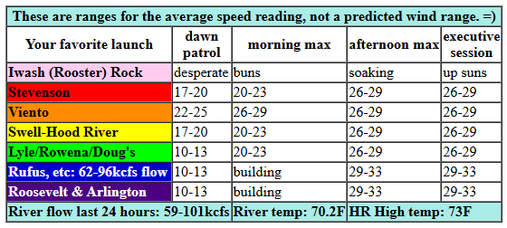
We start with pressures of 30.12/29.97/29.96 for a massive 0.15 (PDX-DLS) and 0.01 (DLS-PSC). Westerlies quickly rise to 25-28mph from Viento to Mosier, with 20-23mph at Stevenson. East of Mosier, the wind will be slower to build; the near east (Doug’s area) and eastern Gorge are starting around 10-13mph. By late morning or early afternoon, we’ll have 26-29mph from Stevenson to Doug’s with 29-33mph from Avery to Rufus. Arlington joins mid-afternoon. Threemile and areas to the east: 17-20ish. For once, models indicate the Swell zone will stay windy all day (probably thanks to reinforcing cold air from an approaching trough) River flow over the last 24 hours was 59-101kcfs, river temp is 70.2F, and high temp forecast is 73F for Hood River and 82F out in the desert.
RIVER FLOW FOR SITES BETWEEN AVERY (EAST OF THE DALLES) AND RUFUS: CLICK HERE FOR JOHN DAY DAM FLOW.
RIVER FLOW FOR SITES BETWEEN STEVENSON AND DOUG’S BEACH (WEST OF THE DALLES): CLICK HERE FOR THE DALLES DAM FLOW

tomorrow’s gorge wind forecast
Uncertainty skyrockets on Friday. Ensembles are all over the place as are the various resolution members of the GFS. If we have any west wind, it should be confined to the Stevenson-Hood River zone. Models have anything from calm wind to 17-20mph west wind. Best shot will be very early in the morning between Viento and Swell and late afternoon from Stevenson to Swell. High temp: 73F.
extended Gorge wind forecast
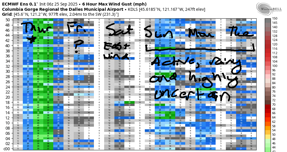
East wind is likely on Saturday morning with a shot at light westerlies ahead of an approaching front on Saturday afternoon. As of right now, it appears easterlies will peak at 20mph near Iwash and 15mph near Stevenson. High temp: 79F. A system approaching on Sunday gives us gusty, moderate-strength westerlies. For now, let’s call it 16-19mph shifting from west to east. That’s quite uncertain, as models are unclear on the timing of an incoming weather system; it could arrive Sunday, and it could arrive on Monday. All that said, the first half of next week (at least!) look damp, cool, and not very windy. So get out there today. See you on the Nch’i Wana!
JONES BEACH, SAUVIE ISLAND, & COAST FORECAST
Wind northerly unless otherwise indicated. For coast, it’s North/Central/South with the “central” at approximately Florence. Swell forecast from NWS for central coast. Jones: westerly unless otherwise stated. Sauvie Island: northerly unless otherwise stated. Coast Thursday: 10/15/15-20/30, NW 8′ @ 10. Friday: LTV/N10-15/N30-35, NW 7′ @ 15. Saturday: LTNW/NW10/20-25, NW 8′ @ 14. Jones Thursday: 13-16. Friday: LTW. Saturday: 14-17. Sauvie Island Thursday: 8-11. Friday: LTN. Saturday: 7-10.
BARE BONES HOOD RIVER WEATHER FORECAST
Clear sky this morning with a few high clouds later. Temps start in the low 60s and rise to the low 70s. Strong to very strong westerlies. No rainbows. Friday starts with a few clouds and turns clear. Temps star tint he upper 40s and rise to the lo w70s. Light westerlies. No rainbows. Saturday will be mostly clear. Temps start near 50 and rise to the upper 70s. Light easterlies. No rainbows.
TEMIRA’S AWESOME TRAVEL ADVISORY SERVICE
HYPERLOCAL WEATHER FORECAST FOR THE COLUMBIA GORGE
THE DALLES, HOOD RIVER, WHITE SALMON, TROUT LAKE, STEVENSON, CASCADE LOCKS, PARKDALE, ODELL, HUSUM, BZ, MILL A, WILLARD, GOLDENDALE, RUFUS, ARLINGTON, boardman
Good morning, neighbors! Here we are again on another Thursday. They just keep coming, don’t they? One a week. It’s incredible. This Thursday happens to be one with a Red Flag Warning posted for extreme fire danger. That’s thanks to strong wind and dry fuels and maybe some other stuff. So please, please don’t do anything that could lead to sparks or fire today. Let’s just make it ’til Monday with no new fires. Hopefully fire danger will start to recede with the arrival of a cooler, moister pattern to start next week.
Glenwood this morning
In the meantime, it’s a clear and cool start to the day. Glenwood continues the sub-40 streak with a morning low of 39 degrees. When it’s 39 degrees in Glenwood, everyone living there gets to be 39 degrees for a day. Elders rejoice in their youth, and youth resent the sudden imposition of “old age”. But everyone learns something – that time is gonna do what it does. Aging is inevitable, fighting it is silly, life is short, and so much joy is possible right here, right now, when we receive this moment with care, curiosity, and kindness.
Today’s Gorge weather forecast
That applies to all of us today as we soak up yet another sunny day. Temps max out in the low 70s (west) right around 80F (The Dalles), and mid 80s (out in the desert where hopefully nobody is growing a watermelon bigger than MINE. MY WATERMELON IS THE BIGGEST ONE!). Very strong west wind accompanies today’s sunshine: 25-30mph average between Stevenson and Mosier and (eventually) 30-35mph from Lyle to Arlington. Be careful out there today, fishing people.
Overnight tonight: lots and lots and lots of stars as humidity plummets and winds turn calm. With 850mb temps falling to 7C tonight, Glenwood is likely to see a frosty Friday morning. The rest of us: 40s, mostly.
Friday’s Gorge weather forecast
A few high clouds early Friday dissipate and leave us completely sunny. Temps range from 73F (west and east) to 79F (The Dalles). Models aren’t sure how windy it will be. Some have it calm. Some give us westerlies at 15-20mph between Stevenson and Mosier or maybe as far east as The Dalles in the afternoon. (forecaster throws up their hands and decides to simply go with the flow, which is generally good advice unless the “flow” happens to be rusing towards authoritarianism, hatred, and cruelty, in which case wading upstream is indicated. Like now.)
Saturday, Sunday, etc., etc., etc… Gorge weather forecast blah blah blah
On Saturday, we’ll have sunshine, 80 degrees, and east wind that maxes out at 20mph near Iwash and Cascade Locks and Stevenson and Viento and Home Valley. The rest of us, including up in the hills, get light easterlies.
Sunday: increasing clouds, 80ish degrees, west wind at 15-20mph.
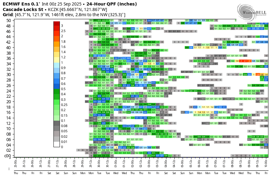
Change arrives on Monday in the form of wetter, cooler weather. Models take the snow level from 9000′ on Monday to 6500′ on Tuesday to 4500′ on Wednesday. Total precip amounts are highly uncertainty all across the region; we’ll have to wait and see how things shake out. If we’re lucky, this will be the first widespread sticking snowfall up in the mountains and will clothe our poor naked volcanoes in a new suit of white. Speaking of naked… I think I’ll go put some clothes on now. Safe travels. -TATAS
HEY! DON’T STOP READING! Is this community-focused forecast helpful to you? It sure is! It takes me a couple hours a day to write. Please join your friends and neighbors in contributing to keep it going. Venmo: @thegorgeismygym PayPal: twomirrors@gmail.com USPS: Temira / PO Box 841 / Hood River, Oregon 97031 You can test out the forecast subscription for a few days for free by signing up below. Easy! Do it!
MT HOOD SNOW FORECAST

CURRENTLY ON VACATION. WILL RETURN SOMETIME BEFORE THE START OF SKI SEASON AT MEADOWS, TIMBERLINE AND SKIBOWL. SAME GOES FOR THE NORDIC SKIING SEASON AT MEADOWS AND TEACUP!
