

GORGE WIND FORECAST
If you’re still seeing yesterday’s and it’s after 9am, try opening this in an incognito window
today’s gorge wind forecast
Hi friends! Westerlies are back, and they’re sticking around IN THE Gorge wind forecast through at least Monday. Before I forget … the Gorge Downwind Champs race is happening Friday starting at 11am. 900 boats will be headed down the river from Home Valley to Hood River. If you encounter them, give them the right of way and cheer them on! Before we dive in to the forecast… just a moment of recognition to the organizers for creating such a great event and bringing so much fun and joy to the lives of so many paddlers!
Another quick note: this forecast predicts speeds on the iWindsurf sensors. The Swell City sensor reads low compared the eastern Gorge sensors. In other words, a prediction of 17-20mph at Swell is equivalent to 22-25mph(ish) at Maryhill, Rufus, Arlington, and Threemile. 30mph at Swell is equivalent to 36-39mph at those eastern Gorge launch sites. Viento also reads high.
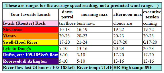
Alright. Thursday started off breezy with pressures of 29.89/29.79/29.76 for gradients of 0.10 (PDX-DLS) and 0.03 (DLS-PSC). Hottest temps shift east of the Cascades today, which keeps the wind westerly. Opening play by Ma Nature is 15-18mph from Viento to Hood River with 5-10mph pretty much everywhere else. By mid-morning, we’ll have 21-24mph from Stevenson to Mosier with 14-17mph east of Mosier to Arlington. Given the lack of clouds in Portland, it’s likely Viento-Hood River will dip to gusty 17-20mph early afternoon. Elsewhere for the afternoon: 19-22mph at Stevenson, 20-23mph between Mosier and Doug’s, and 17-20mph at Rufus. To the east of Rufus: 13-16mph. River flow over the last 24 hours was 105-186kcfs, river temp is 71.4F (poor salmon!), and high temp forecast is 89F for Hood River and 96F for Rufus.
RIVER FLOW FOR SITES BETWEEN AVERY (EAST OF THE DALLES) AND RUFUS: CLICK HERE FOR JOHN DAY DAM FLOW.
RIVER FLOW FOR SITES BETWEEN STEVENSON AND DOUG’S BEACH (WEST OF THE DALLES): CLICK HERE FOR THE DALLES DAM FLOW

tomorrow’s gorge wind forecast
On Friday, a trough of cool air approaches the coast and sets us up for a windier day. While we’re unlikely to see marine clouds in the Gorge or metro area from this system, that reinforcing cold air should help keep the wind going all day. TJ’s Dawn Patrol looks like 21-24 from Viento to Mosier with 17-20mph at Stevenson and 17-20mph east of Mosier to Arlington. Mid-morning win drises to 24-27 from Stevenson to Rufus with 17-20 at Arlington. Afternoon: 24-27+ from Stevenson to Hood river with 27-31 from Mosier to Arlington. 31-34mph is not out of the question for sites east of Mosier. Threemile: probably 25-28mph. High temp: 86F for Hood River and 93F for Arlington.
extended Gorge wind forecast
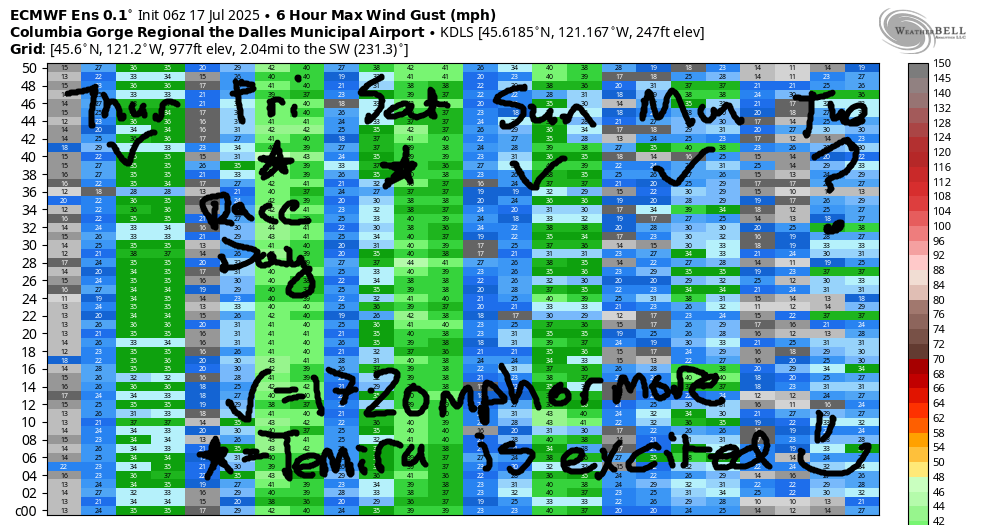
Marine clouds finally make a showing on Saturday on the west side. Combine this with lingering heat in the desert for another widespread windy day. For now, let’s call it 21-24mph to start from Stevenson to Arlington. Westerlies quickly build to 26-29mph from Stevenson (actually, Stevenson could be cloudy and less windy) to Doug’s with 23-26mph at Rufus and 20-23mph at Arlington. Afternoon: windier! 26-29 from Stevenson to Hood River, 28-31mph from Mosier to Arlington, 24-27mph at Threemile. Slightly lesser wind, but still plenty for nearly everyone, is forecast on Sunday. Westerlies of some sort, 17-20+, are in the cards on Monday. Starting Tuesday, models disagree on the overall picture and thus on the strength and even possibility for westerlies. So, I’ll leave it here for now. Have an awesome day ont eh Nch’i Wana today!
Was that helpful? I knew it was! Guess what? All of this crucial work – from your personal wind and snow reports to the invaluable TATAS updates – is made possible by my relentless efforts. Maintaining this labor of love isn’t easy. Each daily forecast takes hours. Website hosting, weather model access, and back-end admin work takes time and money. That’s where you come in.
YOUR CONTRIBUTION MAKES A DIFFERENCE
- SUPPORT ACCURATE, HYPER-LOCAL WEATHER FORECASTING
- ENABLE ACCESS FOR ALL, EVEN THOSE WITH LESS MEANS
- SUPPORT A COOL HUMAN WHO WORKS HARD SO YOU CAN PLAY
Take a moment to click one of the buttons below. Donate $19.99 or more (how much does this forecast enhance your life?) and get the email in your inbox. Whether it’s a renewing subscription (auto-renew) or a one-time donation, every contribution makes a real difference. Help me keep this labor of love alive, so we can all continue playing, commuting, and living in the Gorge with peace of mind and the best weather forecasts possible. Thank you!


Hood River, Oregon 97031


JONES BEACH, SAUVIE ISLAND, & COAST FORECAST
Wind northerly unless otherwise indicated. For coast, it’s North/Central/South with the “central” at approximately Florence. Swell forecast from NWS for central coast. Jones: westerly unless otherwise stated. Sauvie Island: northerly unless otherwise stated. Coast Thursday: LTNW/LTNW/N10-15, NW swell 7′ at 10 seconds. Friday: NW10/NW15/N25, NW 6′ @ 9. Saturday: LTNW/N10-15/N25-30, NW 5′ @ 8. Jones Thursday: 19-22. Friday: 16-19. Saturday: 14-17. Sauvie Island Thursday: 7-10. Friday: 14-17. Saturday: 9-12.
BARE BONES HOOD RIVER WEATHER FORECAST
Clear sky all day Thursday. Temps start in the mid 60s and rise to the upper 80s. Moderately strong westerlies. No rainbows. Friday will be clear then high cloudy. Temps start in the low 60s and rise to the mid 80s. Strong westerlies. No rainbows. Saturday will be partly cloudy then mostly clear. Temps start near 60 and rise to the upper 70s. Strong westerlies. No rainbows.
TEMIRA’S AWESOME TRAVEL ADVISORY SERVICE – THURSDAY 7/17
HYPERLOCAL WEATHER FORECAST FOR THE COLUMBIA GORGE
THE DALLES, HOOD RIVER, WHITE SALMON, TROUT LAKE, STEVENSON, CASCADE LOCKS, PARKDALE, ODELL, HUSUM, BZ, MILL A, WILLARD, GOLDENDALE, RUFUS, ARLINGTON, boardman

Good morning, neighbors! You did it! You made it through the hottest of the hot weather. And now we jump on the downward temp slide, which is like a slip n’ slide only less wet. Way less wet. We have no rain in the near future. And we have a red flag warning for extreme fire danger posted by NWS Portland and Pendleton through Friday evening. Be careful with fire out there! Fire restrictions go into effect today on National Forest System lands in the Scenic Area: campfires are prohibited, including in developed campgrounds; smoking is prohibited outside of a building or vehicle or designated campground. Other forest areas are also starting to implement restrictions, and private lands are likely to follow soon. Okay, moving on…
GLENWOOD THIS MORNING AND SOME OTHER RANDOM SHIT
So, you might have guessed it’ll be hot and windy today. That’s true, but it didn’t start out that way in Glenwood. The little hidden hamlet with energy drink slurpees started today at 47 degrees. Those slurpees are why everyone in Glenwood gets so much done. It’s also why they can work so hard – caffeine is one of the few legal substances that reduces perceived exertion. Others are beets and rhodiola.
TODAY’S GORGE WEATHER FORECAST
For the rest of us today, we’ll have warm and breezy weather. After a 60-something degree start (all my windows are open, and so are my doors – how about yours?) temps rise to 89 (west), 96 (The Dalles) and 96 (way out east where the watermelons grow and the bighorn sheep roam and cowboys watch Brokeback Mountain and shed tears of joy and longing). West wind returns today: 15-20mph between Stevenson and Mosier this morning. 20-25mph between Stevenson and Rufus this afternoon with less to the east. Overnight: clear, low 60s, with a waning gibbous moon and a few fireballs from the Alpha Capricornids meteor shower.
FRIDAY’S GORGE WEATHER FORECAST
Another sunny, windy, warm day is in the cards Friday, but everyone will be screaming, “TGIF,” and ignoring the heat. Don’t ignore the fire danger: between the heat and the wind, it’ll be extreme. Westerlies start at 20mph all the way from Stevenson to Arlington. The wind rises to 25-30mph from Stevenson to Mosier and 25-35mph from Mosier to Arlington with 20-25mph east to Boardman. Up in the hills, we’ll start with NW 15-20 and rise to W 25-30mph. High temps will be 86 (west), 93 (The Dalles) and 98 (out in the desert where the cowboys will still be reeling after watching Brokeback Mountain). In a fun twist, high clouds arrive in the afternoon and shift the sky from blue to partly gray or white.
SATURDAY’S GORGE WEATHER FORECAST
Saturday: cooler, yay! Cooler to start (upper 50s to low 60s), and cooler to finish (78 west, 91 east). We might even start the day with some welcoming low clouds west of Hood River. We’ll finish it with a few high clouds. West wind will be 20-25mph from Stevenson to Arlington in the morning and 25-35mph from Stevenson to Threemile Canyon in the afternoon. While the current Red Flag Warning doesn’t continue into Saturday, fire danger will still be extreme. Don’t fuck around with sparks, and don’t fuck, because fucking can create sparks. Or at least use lots of lube, because friction is not only painful – it can lead to coals, sparks, and outright flames. As well as a very sore vag*na or an*s. Butt sex FTW!
EXTENDED GORGE WEATHER FORECAST
Looking to Sunday, we see another somewhat cool, rather breezy day. Ditto on Monday. From Tuesday on, uncertainty is high. As high as a kite. As high as an elephant’s eye. Knee high fourth of July. Buy low, sell high. Knee-high to a grasshopper. Through hell and high water, we’ll ride high in the saddle and take the high road. Be kind and compassionate out there today, folks. Safe travels. -TATAS
HEY! DON’T STOP READING! Is this community-focused forecast helpful to you? It sure is! It takes me a couple hours a day to write. Please join your friends and neighbors in contributing to keep it going. Venmo: @thegorgeismygym PayPal: twomirrors@gmail.com USPS: Temira / PO Box 841 / Hood River, Oregon 97031 You can test out the forecast subscription for a few days for free by signing up below. Easy! Do it!
