

GORGE WIND FORECAST
If you’re still seeing yesterday’s and it’s after 9am, try opening this in an incognito window
today’s gorge wind forecast
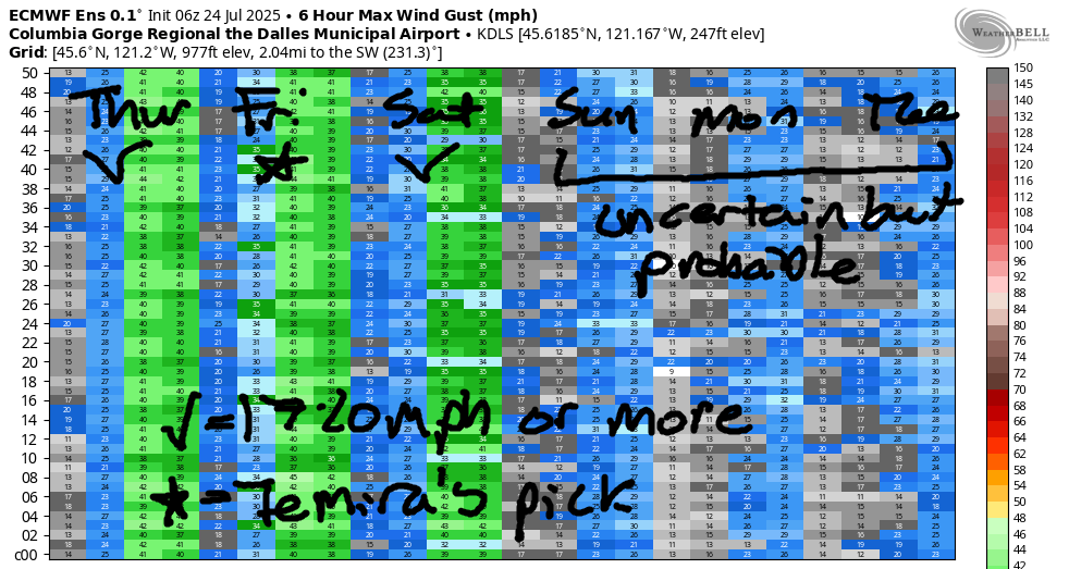
Hi friends! It’s a promising start to Thursday in the Gorge with a solid early-morning gradient. Moderately strong to strong wind persists in the Gorge wind forecast through Saturday, with 17-20+ likely through at least Tuesday, when we’ll have blow dryer wind: hot. There’s some potential for a big day next week when temps drop again, but there’s also a lot of uncertainty in the forecast. Doug’s Beach remains close due to the Burdoin Fire, SR-14 remains closed between Bingen and Lyle, and fire crews continue to request that you do not recreate on the river in areas where crews are using aircraft to scoop water. Those locations can change based on conditions, so stay alert and be prepared to leave.
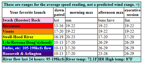
Taking a look at Thursday morning, we see zero marine clouds in Portland, a few in Vancouver, and these pressures to start: 30.08/29.98/29.95. That gives us 0.10 (PDX-DLS) and 0.03 (DLS-PSC). Dawn Patrol wind was 17-20mph at Viento with 10-13mph pretty much everywhere else between Stevenson and Arlington. We’ll see a quick build to 19-22mph from Stevenson to Mosier with 16-19mph at Hood River and 15-18mph between Lyle and Rufus. Afternoon wind drops to 16-19mph from Swell to Hood River, rises to 23-26mph between Mosier and Arlington, and holds at 19-22mph between Stevenson and Viento. Late afternoon: 26-29mph between Lyle and Arlington with 22-25mph at Threemile. River flow over the last 24 hours was 95-198kcfs (that peak was around 8pm), river temp is 72.1F (poor salmon!), and high temp forecast is 87F for Hood River and mid 90s out in the desert.
RIVER FLOW FOR SITES BETWEEN AVERY (EAST OF THE DALLES) AND RUFUS: CLICK HERE FOR JOHN DAY DAM FLOW.
RIVER FLOW FOR SITES BETWEEN STEVENSON AND DOUG’S BEACH (WEST OF THE DALLES): CLICK HERE FOR THE DALLES DAM FLOW

tomorrow’s gorge wind forecast
Friday sees marine clouds push into the metro area to start the day. This increases the onshore flow and the stability of the wind field. We’ll start with 23-26mph between Viento and Mosier with 15-18mph from Lyle to Arlington. Stevenson takes its time due to cloud cover. By late morning or early afternoon, we’ll have 24-27mph from Stevenson to Rufus with 24-27mph at Arlington. Westerlies build to 27-31mph between Mosier and Arlington mid-afternoon and hold into the evening. High temp: 80F for Hood River and 89F for Rufus.
extended Gorge wind forecast
Models hint at deeper, more persistent marine clouds on Saturday, which would normally give us stronger wind. But they also hint at the offshore high weakening and a weak disturbance moving through. As of now, we’re looking at 20-23mph to start from Viento to Swell. Afternoon wind looks like 26-29mph from Mosier to Arlington with uncertainty at Swell depending on what the clouds do. High temp: 79F for Hood River and 86F at Rufus.
A warming trend starts on Sunday, as does some movement offshore. I’ll spare ya the details, but essentially it looks like wind speeds will dip for the Sunday-Tuesday time period. As of this morning, it looks like we’ll still have 17-20mph+ each day, but it’s going to be right on the edge. Add in the potential for thunderstorms on Tuesday, and the forecast becomes more uncertain. Models hint at a cooldown in the Wednesday-Friday time period. That would normally give us a strong day (and models are hinting at one Thursday), but southerly flow and thunderstorm potential may complicate things. So, we’ll keep looking as we get closer to that time frame. In the meantime… have a great day on the Nch’i Wana. I’ll see you out there!
Was that helpful? I knew it was! Guess what? All of this crucial work – from your personal wind and snow reports to the invaluable TATAS updates – is made possible by my relentless efforts. Maintaining this labor of love isn’t easy. Each daily forecast takes hours. Website hosting, weather model access, and back-end admin work takes time and money. That’s where you come in.
YOUR CONTRIBUTION MAKES A DIFFERENCE
- SUPPORT ACCURATE, HYPER-LOCAL WEATHER FORECASTING
- ENABLE ACCESS FOR ALL, EVEN THOSE WITH LESS MEANS
- SUPPORT A COOL HUMAN WHO WORKS HARD SO YOU CAN PLAY
Take a moment to click one of the buttons below. Donate $19.99 or more (how much does this forecast enhance your life?) and get the email in your inbox. Whether it’s a renewing subscription (auto-renew) or a one-time donation, every contribution makes a real difference. Help me keep this labor of love alive, so we can all continue playing, commuting, and living in the Gorge with peace of mind and the best weather forecasts possible. Thank you!


Hood River, Oregon 97031


JONES BEACH, SAUVIE ISLAND, & COAST FORECAST
Wind northerly unless otherwise indicated. For coast, it’s North/Central/South with the “central” at approximately Florence. Swell forecast from NWS for central coast. Jones: westerly unless otherwise stated. Sauvie Island: northerly unless otherwise stated. Coast Thursday: LTNW/N10/N15-20, NW swell 3′ at 8 seconds. Friday: NW 5-10/NW5-10/N25, NW 3′ @ 8. Saturday: LTNW/LTNW/N15, NW 3′ @ 8. Jones Thursday: 17-20. Friday: 13-16. Saturday: 17-20. Sauvie Island Thursday: 13-16. Friday: 9-12. Saturday: 7-10.
BARE BONES HOOD RIVER WEATHER FORECAST
Clear sky all day. Temp start in the upper 60s and rise to the upper 80s. Moderately strong westerlies. No rainbows. Friday will be mostly clear then clear. Temps start in the upper 50s and rise to 80. Strong westerlies. No rainbows. Saturday will be partly cloudy then mostly clear with a few high clouds. Temps start in the upper 50s and rise to the upper 70s. Moderate to moderately strong westerlies. No rainbows.
TEMIRA’S AWESOME TRAVEL ADVISORY SERVICE
HYPERLOCAL WEATHER FORECAST FOR THE COLUMBIA GORGE
THE DALLES, HOOD RIVER, WHITE SALMON, TROUT LAKE, STEVENSON, CASCADE LOCKS, PARKDALE, ODELL, HUSUM, BZ, MILL A, WILLARD, GOLDENDALE, RUFUS, ARLINGTON, boardman
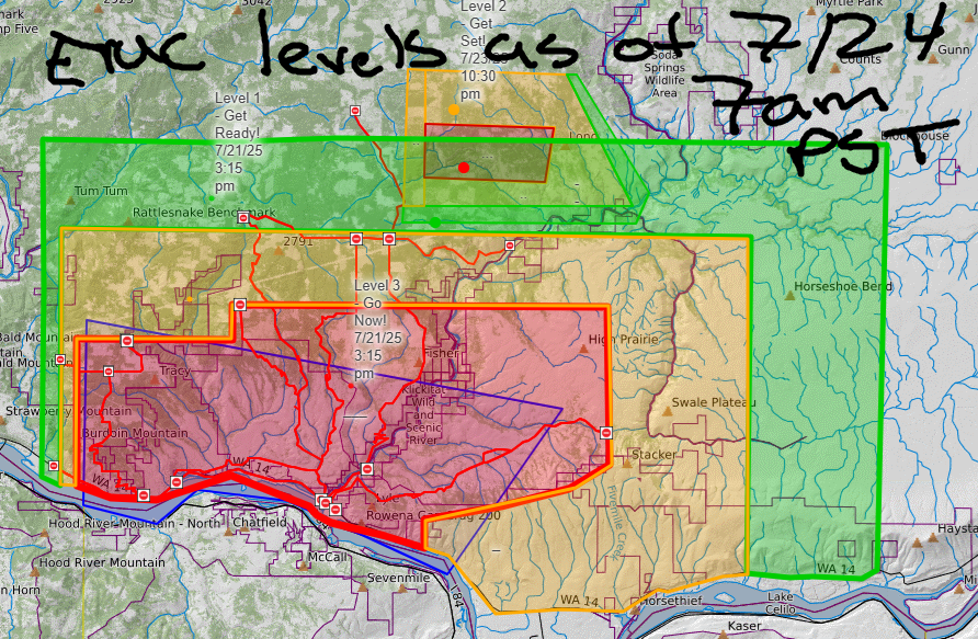
Good morning, neighbors! Another warm and breezy summer day is on tap for the good old Columbia Gorge. And we have yet another fire, Brewer Road, to contend with, but fortunately this one appears to be growing slowly. THANK YOU FIRE CREWS! Evac levels in Klickitat County are getting a bit confusing. I put together a map of the combined levels as of this morning (7/24), but that map doesn’t automatically update when the underlying maps update. So make sure to check the updated maps linked to on WatchDuty. On to the general weather picture: hot and breezy today. A bit cooler and breezier through the weekend. Warming again starting Sunday with a chance of thunderstorms starting Tuesday as (maybe) southerly flow and monsoonal moisture are pulled into the area by a (maybe) trough or low that sets up along the coast. Hottest day: Tuesday, when temps will push towards 100 for The Dalles. Windiest day: probably Friday, when westerlies will rise to 25-35mph.
glenwood this morning
Let’s dig into the details like a gopher digging around looking for nasturtiums and parsley and dahlia tubers. But first, Glenwood. Glenwood started the morning practicing gratitude for not being under any sort of evacuation level. It was 50 degrees, not windy, and sunny. 49% of the folks were drinking coffee, and 48% were drinking energy drink slushee from the General Store. The other 3% were still asleep despite the barking of hungry dogs, the meowing of thirsty cats, and the crowing of roosters entranced by the rising sun.
today’s gorge weather forecast
For the rest of us today: sunshine and blue sky. Temps rise to the upper 80s (west), low 90s (The Dalles), and upper 90s (out near Hermiston where people are already harvesting watermelons). West wind rises to 20-25mph between Stevenson and Mosier this morning with 20-30mph between Mosier and the Arlington Triangle (where moisture enters a wormhole and reappears in Bermuda). Overnight, we’ll have clear sky and a new moon (on Monday), perfect for watching the ISS zip across the sky in a poor imitation of all the meteors falling from the three currently active showers.
Speaking of showers… there aren’t any in the forecast until next week.
friday’s gorge weather forecast
On Friday, we might see a few clouds west of Wyeth to start the day. Thanks to that, temps will be down a bit, and the wind will be up a bit. Early temps will be in the upper 50s. Afternoon: 80 (west), 86 (The Dalles – really cool for there this time of year!), and 93 (out in the desert where the buffalo used to roam but now there are just Bighorn Sheep and windmills). West wind will be 25mph between Viento and Mosier to start the day and 25-35mph from Stevenson to the Arlington Triangle in the afternoon. Let’s not start any fires, okay?
saturday’s gorge weather forecast
Saturday looks a couple degrees cooler than Friday, a bit cloudier in the morning, and just a touch less windy in the afternoon. Sunday looks like another sunny day with temps in the low 80s to the west and low 90s in the desert. Wind will be down a bit: 20mph or so rather than 30mph-ish. We then tumble into a warming trend through Tuesday or Wednesday.
extended gorge weather forecast
This warming trend might just be accompanied by southerly flow aloft (and westerly flow at the surface), which will drag in both heat and moisture. Deets depend on how an offshore trough behaves, but one possible outcome is thunderstorms, lightning, and rain in that Tuesday-Wednesday window. We’ll be keeping a close eye on this. Rain sounds great. Lightning and the associated potential for wildfire sounds not-good. Okie dokie. Be careful out there the next couple of days with your spark-causing things. Set aside the mower, the weed-whacker, the dragging trailer chains, and the fireworks (why would you even have them?!?!). Safe travels. -TATAS
HEY! DON’T STOP READING! Is this community-focused forecast helpful to you? It sure is! It takes me a couple hours a day to write. Please join your friends and neighbors in contributing to keep it going. Venmo: @thegorgeismygym PayPal: twomirrors@gmail.com USPS: Temira / PO Box 841 / Hood River, Oregon 97031 You can test out the forecast subscription for a few days for free by signing up below. Easy! Do it!
