

GORGE WIND FORECAST
If you’re still seeing yesterday’s and it’s after 9am, try opening this in an incognito window
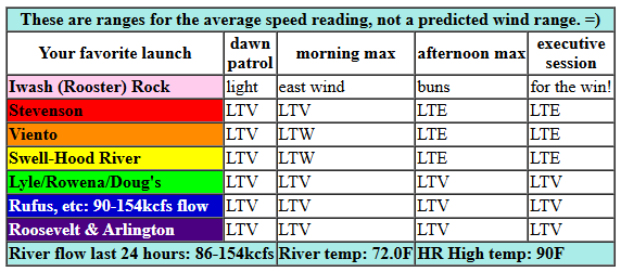
today’s gorge wind forecast
Hi friends! It’s Thursday, and the Gorge wind forecast has a lot of heat and not all that much wind through the end of this hot spell. We’ll even see a couple days of easterlies at metro area heating exceeds Gorge heat for a couple of days. West/onshore wind returns (probably) Sunday and sticks around, but the wind strength looks questionable through the middle of next week. It’s unclear when this hot spell will end – each day I look, models have extended it. Maybe towards the end of next week? I’m headed out on a meditation retreat next Friday through next Wednesday, so I’ll be taking a forecast break for five days or so. Which should guarantee it will nuke in the Corridor every day!
Looking at Thursday morning, we have sunshine from the coast to the Gorge. Early pressures were 30.20/30.16/30.16 for onshore gradients of 0.04/0.00. Models have a little wind this morning, perhaps 11-14mph from Viento to Swell before the wind calms. Models even have the wind turning easterly at 10mph midday near Stevenson. That said, the metro area is supposed to be a couple degrees cooler than Hood River, so the wind could stay light westerly. Either way, it’ll be light. River flow over the last 24 hours was 86-154kcfs, river temp is 72.0F, and high temp forecast is 90F and sunny!
RIVER FLOW FOR SITES BETWEEN AVERY (EAST OF THE DALLES) AND RUFUS: CLICK HERE FOR JOHN DAY DAM FLOW.
RIVER FLOW FOR SITES BETWEEN STEVENSON AND DOUG’S BEACH (WEST OF THE DALLES): CLICK HERE FOR THE DALLES DAM FLOW

tomorrow’s gorge wind forecast
A heat low (pressure) settles into the Willamette Valley on Friday. This turns the wind offshore/easterly. Opening play is 25mph at Iwash (Rooster) Rock and 20-25mph at Stevenson. Home Valley and Viento: 20mph. Late morning fade rule is in effect: by 2pm, the wind will be 20-25mph at Iwash Rock, 15-20mph at Stevenson, and 15mph at Home Valley and Viento. The wind drops to 15mph or less mid to late afternoon. Near Hood River and eastward in the afternoon, easterlies pick up to 5-10mph. High temp: 95F and sunny.
extended Gorge wind forecast
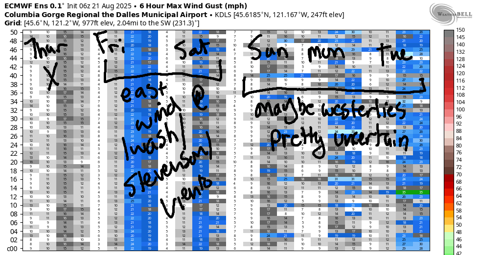
Saturday looks a bit lighter as hotter temps settle in all across the region and squish the gradients down to nearly-nothing. Early wind will be 15-20mph at Stevenson and Iwash with 15mph at Home Valley and Viento. Get it quickly. By afternoon, the wind drops below 10mph everywhere.
Models hint at westerlies returning on Sunday as the heat low (hottest temps and associated low pressure) shift into the desert. As of this morning’s model run, we’re looking (broad-brushing this) upper teens Sunday through Wednesday. Ensembles do hint at the possibility of stronger wind starting Wednesday and continuing day after day beyond that. Naturally – I’ll be on a meditation retreat starting Friday afternoon through the following Wednesday. That should guarantee strong wind for a week! Stay cool during this hot spell. Starting tomorrow (unless I keep waking up at 4:30am, I’m going to switch to evening forecasts so I can take advantage of the cool morning hours. See you on the Nch’i Wana!
JONES BEACH, SAUVIE ISLAND, & COAST FORECAST
Wind northerly unless otherwise indicated. For coast, it’s North/Central/South with the “central” at approximately Florence. Swell forecast from NWS for central coast. Jones: westerly unless otherwise stated. Sauvie Island: northerly unless otherwise stated. Coast Thursday: 20/25/30, SW swell 2′ at 15 seconds. Friday: 25/10-15/20-25, N 3′ @ 4. Saturday: NW5-10/NNW10/N20-25, N 3′ @ 4. Jones Thursday: 10-13. Friday: LTW. Saturday: 13-16. Sauvie Island Thursday: 14-17. Friday: 13-16. Saturday: 8-11.
BARE BONES HOOD RIVER WEATHER FORECAST
Sunny all day Thursday. Temps start near 50 (open ALL the doors and windows!) and finish near 90 (shut ‘er down). Light and variable wind. No rainbows. Friday will be sunny. Temps start in the upper 50s and rise to the mid 90s. Light easterlies. No rainbows. Saturday starts sunny and adds some high clouds. Temps start in the mid 60s and rise to the upper 90s. Light easterlies. No rainbows.
TEMIRA’S AWESOME TRAVEL ADVISORY SERVICE – THURSDAY 8/21
HYPERLOCAL WEATHER FORECAST FOR THE COLUMBIA GORGE
THE DALLES, HOOD RIVER, WHITE SALMON, TROUT LAKE, STEVENSON, CASCADE LOCKS, PARKDALE, ODELL, HUSUM, BZ, MILL A, WILLARD, GOLDENDALE, RUFUS, ARLINGTON, boardman

Good morning, neighbors! Our biggest, baddest, most beautiful heat spell of the summer is on the horizon. Like the sun, this period of time will be blazing hot. Today’s the coolest until the middle of next week; we’re expecting a long strong of 95+ degree days with lots of triple digits for folks living in The Dalles and areas to the east. Up in the mountains, where you can usually escape the heat, temps look to be 25C+ up to 5000′. Not much heat relief up there, even at night, when it’ll still be quite warm. When will cooler weather arrive? Maybe next Wednesday, but maybe a bit deeper into the future than that. Stock up on bubbly water. Stake out a spot at a swimming hole. Stay hydrated. THANK YOU FOR YOUR ATTENTION TO THIS MATTER.
Glenwood this morning
Checking in with Glenwood this morning, we see anything but “hot”. My usual sensor is down, but the backup one says 37 degrees!!! that must feel really chilly, because this morning’s 50 degree reading in Hood River feels chilly to me. Remember what I said the other day – 50-52F degrees is the average morning low for Hood River. It’s been a summer of very, very warm mornings (which is totally consistent with the changes expected with global warming, sad).
Today’s Gorge weather forecast
Weather for Thursday: 90-94F degrees and sunny after this pleasantly chilly start. If you open all the doors and windows this morning and stock up on chilly air, you’ll be a happy clam this afternoon. Today’s wind won’t provide much relief; it’ll be light and variable all day with a period of E 10mph possible near Cascade Locks mid-morning.
Weekend Gorge weather forecast
Hot weather really settles in on Friday, when the west side reaches 95+ degrees, The Dalles climbs to 100F, and the desert reaches the upper 90s. Sky: 100% clear, much like your poop after round II of colonoscopy prep. Kids, you have something to look forward to! Back to the weather: temps start out near 60F. Enjoy that – morning temps keep climbing through this hot spell. Friday’s wind: 20-25mph at Iwash (cock) Rock and Stevenson early with 15-20mph from Home Valley to Viento. East of there: light. Afternoon wind falls to 10-15mph between Iwash (dick) Rock and Viento and rises to 5-10mph from Hood River east into the desert. Let’s not start any fires, okay? High temps, east wind, and low humidity is a bad combo. Saturday looks a few degrees warmer, 5mph less windy, and might add a few high clouds in the afternoon. Sunday: About the same, but the wind might switch direction. Humidity starts to ramp on on Sunday evening (maybe) as monsoonal moisture drifts in from the south.
Extended Gorge weather forecast
Monday through Wednesday all look quite warm, morning and afternoon, and quite muggy – dewpoint 55F+. In that time period, there may be periods of atmospheric instability: clouds with a slight chance of thunderstorm. If we get lucky, cloud coverage will keep temps lower than expected. With PWAT (not twat, you twat) expected to be in the 0.8” to 1.1” range (roughly), any thunderstorms that do happen would have the potential to drop significant moisture. PLEASE LET IT RAIN! That is all for now. Safe travels. -TATAS
HEY! DON’T STOP READING! Is this community-focused forecast helpful to you? It sure is! It takes me a couple hours a day to write. Please join your friends and neighbors in contributing to keep it going. Venmo: @thegorgeismygym PayPal: twomirrors@gmail.com USPS: Temira / PO Box 841 / Hood River, Oregon 97031 You can test out the forecast subscription for a few days for free by signing up below. Easy! Do it!
MT HOOD SNOW FORECAST

CURRENTLY ON VACATION. WILL RETURN SOMETIME BEFORE THE START OF SKI SEASON AT MEADOWS, TIMBERLINE AND SKIBOWL. SAME GOES FOR THE NORDIC SKIING SEASON AT MEADOWS AND TEACUP!
