

GORGE WIND FORECAST

today’s gorge wind forecast
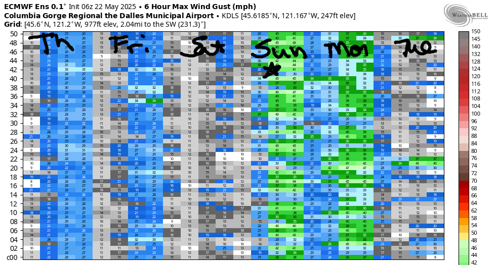
Hi friends! It’s drizzly and not-windy out there this morning, but the wind will return this afternoon according to my version of the Gorge wind forecast. Conditions look marginal both Friday and Saturday, but it appears we’ll see stronger wind Sunday and Monday with a couple of caveats. Looking into the extended forecast, where the ensembles drive my opinions, we’ve got good potential next Wednesday and Thursday, although instability might be a problem on Wednesday. That’s a long ways out. Just have it on your radar for now!
Looking at Thursday… a system moving through is giving us some rain this morning. Early pressures were 30.05/30.01/29.96 for gradients of 0.04/0.05. On the river: 0-10mph most places with 13-16 way out east beyond Threemile. As this system starts to clear mid to late morning, the zone from Stevenson to Mosier rises to 14-17. Lyle-Rufus won’t be far behind – that section rises to 17-20 late morning or early afternoon. That’s it until the executive session; after 5pm, models knock Stevenson-Moiser down to 10-13 and nudge Lyle-Rufus up to 24-27. Arlington looks like 20-23, and Threemile 15-18. River flow over the last 24 hours was 159-237kcfs (159-237kcfs at Rufus), river temp is 57.20F, and high temp forecast is 66F with decreasing clouds.

tomorrow’s gorge wind forecast
A weak system Friday morning starts us off with light wind, but ridging building in the afternoon gives us some hope. The day starts with 10-13 from Viento to Swell. Stevenson: 5-10mph, and same for Hood River and Mosier. Farther east, the day starts calm. Afternoon westerlies, perhaps mid-afternoon on, rise to 14-17 from Stevenson to Doug’s with 7-10 near Rufus and less farther east. High temp: 72F with mostly cloudy sky in the morning and mostly clear sky in the afternoon.
extended Gorge wind forecast
Inland ridging persists on Saturday. Offshore: not much support from there either. We’ll be relying on thermals, which means we’re waiting until afternoon. Expect calm wind or less than 10mph to start the day. Westerlies pick up mid-afternoon and rise to 17-20 from Stevenson to Avery with 7-10mph east of Avery. High temp: 81F and mostly clear.
This pattern breaks down on Sunday and sets us up for a stronger day. Without getting too lost in the weeds, it’s worth mentioning that we’ll have shear and southerly flow aloft. This puts us at risk for instability and thunderstorms in the afternoon, which isn’t great for wind. That said, we’ll have a solid thermal gradient in place and should see mid to upper 20s for the Corridor (near Hood River) and near east (Rowena zone). Monday’s Dawn Patrol currently looks good, but the wind is likely to fade some in the afternoon. Still… there should be enough to get you on the river. Beyond that, model uncertainty multiples as ensemble members argue about troughing vs. ridging. That said, the Euro ensembles are rather optimistic about next Wednesday and Thursday. At this point, there’s really too much uncertainty to lock in a forecast, but I’m definitely keeping an eye on those days. Have a great day on the the river!
Was that helpful? I knew it was! Guess what? All of this crucial work – from your personal wind and snow reports to the invaluable TATAS updates – is made possible by my relentless efforts. Maintaining this labor of love isn’t easy. Each daily forecast takes hours. Website hosting, weather model access, and back-end admin work takes time and money. That’s where you come in.
YOUR CONTRIBUTION MAKES A DIFFERENCE
- SUPPORT ACCURATE, HYPER-LOCAL WEATHER FORECASTING
- ENABLE ACCESS FOR ALL, EVEN THOSE WITH LESS MEANS
- SUPPORT A COOL HUMAN WHO WORKS HARD SO YOU CAN PLAY
Take a moment to click one of the buttons below. Donate $19.99 or more (how much does this forecast enhance your life?) and get the email in your inbox. Whether it’s a renewing subscription (auto-renew) or a one-time donation, every contribution makes a real difference. Help me keep this labor of love alive, so we can all continue playing, commuting, and living in the Gorge with peace of mind and the best weather forecasts possible. Thank you!


Hood River, Oregon 97031


JONES BEACH, SAUVIE ISLAND, & COAST FORECAST
Wind northerly unless otherwise indicated. For coast, it’s North/Central/South with the “central” at approximately Florence. Swell forecast from NWS for central coast. Jones: westerly unless otherwise stated. Sauvie Island: northerly unless otherwise stated. Thursday: NW10/N10-15/N20, NW swell 5′ at 9 seconds. Friday: NW10-15/N15/N25, W 3′ @ 9. Saturday: LTW/NW10/N15, W 3′ @ 11. Jones Thursday: 10-13. Friday: 21-24. Saturday: 20-23. Sauvie Island Thursday: W 10-13. Friday: N12-15. Saturday: LTV.
BARE BONES HOOD RIVER WEATHER FORECAST
Drizzle this morning gives way to partly cloudy sky this afternoon. Temps start in the low 50s and rise to the mid 60s. Light westerlies early. Moderate later. 93% chance of rainbows. Friday will be mostly cloudy then mostly clear. Temps start in the mid 40s and rise to the low 70s. Light to moderate westerlies. No rainbows. Saturday will be partly high overcast then clear. Temps start in the mid 40s and rise to the low 80s. Calm wind early. Moderate westerlies later. No rainbows.
TEMIRA’S AWESOME TRAVEL ADVISORY SERVICE – THURSDAY 5/22
HYPERLOCAL WEATHER FORECAST FOR THE COLUMBIA GORGE
THE DALLES, HOOD RIVER, WHITE SALMON, TROUT LAKE, STEVENSON, CASCADE LOCKS, PARKDALE, ODELL, HUSUM, BZ, MILL A, WILLARD, GOLDENDALE, RUFUS, ARLINGTON, boardman
Good morning, neighbors! What a gorgeous drizzly morning we have! While areas east of Hood River are mostly reporting trace amounts of rain, many stations between Parkdale and Trout Lake and to the west are reporting around a quarter inch of rain. We even have a report of 0.46” at York Hill! This is great news. This is also the last rain we’ll see for a while unless we pick some up in thundershowers on Sunday or during the middle part of next week.
Good morning, Glenwood!
Checking in with Glenwood this morning… 47 degrees and cloudy there with 0.18” rain in the last 24 hours. Very nice!
today’s gorge weather forecast
For the rest of us… drizzle to The Dalles or Amayah’s (the location formerly known as Biggs) until mid morning, then clearing sky. After a 45-50 degree start, we rise to the mid 60s. It might feel a bit muggy with the damp ground. Enjoy. It’s good for your skin. Or something. Westerlies pick up to 15-20mph west of Lyle this morning with 20-30mph from Lyle to Arlington this evening. That is all.
FRIDAY’S GORGE WEATHER FORECAST
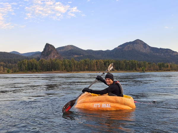
Tomorrow is Friday, yay! Know what happens on Friday (other than lots of gratitude for the end of the workweek, if “workweek” applies to you)? Gary – you remember pumpkin paddle Gary – starts his next attempt at a world record pumpkin paddle. Gary decided to try something unprecedented. He grew a giant pumpkin in a greenhouse this winter. His journey starts at 3:30pm on Friday. You can follow him on his website, and if you’re lucky, you might just see him paddling down the Nch’i Wana this weekend. Weather will be great for paddling a giant pumpkin: mostly clear with temps in the mid 40s early and low 70s later. We’ll start the day with light west wind. We’ll finish with 15mph between Stevenson and The Dalles and 5-10mph to the east.
While you’re sleeping Friday night, Gary will likely be paddling his pumpkin towards the metro area.
SATURDAY’S GORGE WEATHER FORECAST
On Saturday, Gary continues paddling through a warm, sunny day. We start partly high overcast with a pretty sunrise potential. In the afternoon, the sky clears and temps rise to the low 80s. Hey. That’s HOT. I did not authorize that! Calm wind early (or very light westerlies) rises to 15mph between Stevenson and Mosier in the afternoon with lighter wind to the east. Know what else will happen on Saturday, given the sunshine, reasonable temps, and calm wind? Lots and lots and lots of people baring their buttocks at Buttock Rock (I mean Iwash Rock, which actually means “cock rock” – people will be baring their cocks too) in hopes of turning their skin a shade or two darker.
sUNDAY’S GORGE WEATHER FORECAST & THE EXTENDED FORECAST
We’ll lose a few degrees of warmth and pick up some west wind on Sunday. Highs will be in the mid 70s (perfect), and westerlies rise to 25-30mph (also perfect). Models are hinting at instability on Sunday evening and night as shear (differences in wind at elevation) increases and upper flow turns southerly. While there’s not a ton of moisture available to aid in thunderstorm development, there’s a slight chance of something happening. Which makes Sunday night a great night for a barbecue. TATAS recommends you barbecue gophers, as that does everyone a service.
On to next week: 70+ degrees and windy Monday and Tuesday. After that: lots of uncertainty in the models. I deign to speak further on this topic at this time. Safe travels. -TATAS
HEY! DON’T STOP READING! Is this community-focused forecast helpful to you? It sure is! It takes me a couple hours a day to write. Please join your friends and neighbors in contributing to keep it going. Venmo: @thegorgeismygym PayPal: twomirrors@gmail.com USPS: Temira / PO Box 841 / Hood River, Oregon 97031 You can test out the forecast subscription for a few days for free by signing up below. Easy! Do it!
