

GORGE WIND FORECAST
today’s gorge wind forecast
Hi friends! Hopefully you’re in really good windsport shape, because Gorge wind forecast ensembles have lots and lots of wind coming up in the next week. The restiest of days – there will be easterlies, so it’s not a perfect rest day – is Friday, when high pressure briefly takes over. Starting Saturday, offshore high pressure settles in and strengthens, and this sets us up for an extended period of wind with a true nuker possible on Saturday.
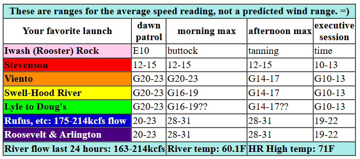
Thursday started with pressures of 30.07/29.96/29.85 for gradients of 0.11 (pdx-dls) and 0.11 (dls-psc). With a front moving through and instability present as I was writing this around 6am, the wind wasn’t particularly strong: 15-18 most places out east, mid 20s at Viento, and oh, it just jumped to 23mph on the iWind/iKite Swell City sensor. Models insist the 20mph near Swell will be short-lived; the forecast for areas west of The Dalles is 15-18mph(ish) today after that brief 20-23mph start. After 5pm, areas west of The Dalles drop to 11-14. Between Avery and Arlington, we’ll see a quick build to 28-31 (equivalent to 21-24ish on the Swell sensor). For that zone, the wind holds until late afternoon and then drops to 19-22. Between Lyle and Doug’s, we have uncertainty; it’s possible the stronger wind will fill in there, and it’s also possible it won’t. Models say it won’t, but it would take one heck of a cloud push this morning to take that section of river out of the picture. River flow over the last 24 hours was 163-201kcfs (175-214kcfs at Rufus), river temp is 60.1F, and high temp forecast is 71F for Hood River and 76F for Arlington. Expect partly cloudy sky in the west and clear sky out east.

tomorrow’s gorge wind forecast
High pressure builds inland on Friday, a heat low sets up on the west side and over the Cascades, and the wind turns easterly. Early in the day, we’ll have 15mph at Stevenson, Iwash (Rooster) Rock, Home Valley, and Viento. The wind builds to 15-20mph at Stevenson, Home Valley, and Viento, and builds to 20-25mph at Iwash. Expect a couple hours of that. The fade starts late morning or early afternoon, and all spots end at 10-15mph. From Hood River eastward, easterlies pick up to 5-10mph after noon. High temp: 87F and sunny as can be.
extended Gorge wind forecast
saturday’s gorge wind forecast
Saturday’s the day you high-wind lovers have been waiting for. While the ensembles are down a few mph compared to yesterday, they’re still calling for “nuking”. Strong to very strong offshore high pressures settles in. A shortwave moves through and reinforces the cool trough on the west side. Heat lingers in the desert. Dawn Patrol looks like 21-24 from Viento to Mosier with less at Stevenson and less than 10mph out east. If you want somewhat light wind, get it early. By late morning, westerlies rise to 27-30 at the Hatch (which reads low on the sensors) and 29-33 at Viento and from Mosier to Rufus. Afternoon iWind/iKite sensor readings: 29-33 on the west side and 35-38 from Lyle east to Arlington and then eventually to Threemile. Boardman gets 30mph. Stevenson is a little up in the air due to cloudiness, but should have gusty 20-25mph, at a minimum. Know what’s awesome about this other than the awesomeness of nuking? Since the will be wind everywhere, people will be spread out, and crowds will be minimal. There are a couple of for-fun-friend-races happening Saturday: a DW foil race in the Swell area and an IKEA bag DW race from the Point at the Hatch to the Basement at the Hatch. Time is TBD. Please cheer on the racers! High temp: 81F for Hood River and 85F for Arlington.
extended gorge wind forecast
Moving on to Sunday… we have what looks like a classic Corridor day. Very strong offshore high pressure combines with a supportive thermal gradient. Early wind looks like low 20s near Swell. Models have mid 20s in the afternoon, but I think it’ll be stronger thanks to that beast of an offshore high. High temp: 73F. Looking at the extended forecast… models generally keep things windy. It’s a little tricky to be precise about this because the ensemble model is for The Dalles and doesn’t accurately capture the Hatch. Given the overall setup, decent wind looks likely in the Corridor (near Hood River) day after day after day. This means you’d better take advantage of that rest day on Friday! Have fun out there. I’ll see you on the Nch’i Wana!
Was that helpful? I knew it was! Guess what? All of this crucial work – from your personal wind and snow reports to the invaluable TATAS updates – is made possible by my relentless efforts. Maintaining this labor of love isn’t easy. Each daily forecast takes hours. Website hosting, weather model access, and back-end admin work takes time and money. That’s where you come in.
YOUR CONTRIBUTION MAKES A DIFFERENCE
- SUPPORT ACCURATE, HYPER-LOCAL WEATHER FORECASTING
- ENABLE ACCESS FOR ALL, EVEN THOSE WITH LESS MEANS
- SUPPORT A COOL HUMAN WHO WORKS HARD SO YOU CAN PLAY
Take a moment to click one of the buttons below. Donate $19.99 or more (how much does this forecast enhance your life?) and get the email in your inbox. Whether it’s a renewing subscription (auto-renew) or a one-time donation, every contribution makes a real difference. Help me keep this labor of love alive, so we can all continue playing, commuting, and living in the Gorge with peace of mind and the best weather forecasts possible. Thank you!


Hood River, Oregon 97031


JONES BEACH, SAUVIE ISLAND, & COAST FORECAST
Wind northerly unless otherwise indicated. For coast, it’s North/Central/South with the “central” at approximately Florence. Swell forecast from NWS for central coast. Jones: westerly unless otherwise stated. Sauvie Island: northerly unless otherwise stated. Thursday: 15/20/25, W swell 6′ at 11 seconds. Friday: 20/20/25-30, W 5′ @ 12. Saturday: 20-25/25/35+, W 5′ @ 10. Jones Thursday: 12-15. Friday: 19-22. Saturday: 15-18. Sauvie Island Thursday: LTV. Friday: 11-14. Saturday: NNW 15-18.
BARE BONES HOOD RIVER WEATHER FORECAST
Clouds increase this morning and break up this afternoon. Temps start near 60 (warm!) and finish near 70. Moderate westerlies. No rainbows. Friday will be mostly cloudy then clear. Temps tart in the upper 40s (open windows) and rise to the upper 80s (closed windows). Light easterlies. No rainbows. Saturday will be partly cloudy. Temps start in the upper 50s and rise to the low 80s. Moderately strong westerlies early. Nuking later. No rainbows.
TEMIRA’S AWESOME TRAVEL ADVISORY SERVICE – THURSDAY 5/29
HYPERLOCAL WEATHER FORECAST FOR THE COLUMBIA GORGE
THE DALLES, HOOD RIVER, WHITE SALMON, TROUT LAKE, STEVENSON, CASCADE LOCKS, PARKDALE, ODELL, HUSUM, BZ, MILL A, WILLARD, GOLDENDALE, RUFUS, ARLINGTON, boardman

Good morning, neighbors! My what a lovely sunrise we had today. And it was so nice of the sun to rise again this morning so we didn’t freeze into blocks of ice. And it was so nice of the sun to not go supernova last night and burn us all up. It’s Thursday. Here we are again for another day of life in the Gorge.
Glenwood and my boobs
But first, let’s check in with our friends in Glenwood. It’s SO WARM there this morning: 59 degrees. It’s warm enough that everyone is out on the deck enjoying a strong cup of coffee while only wearing a birthday suit. You too can try this. I’m doing the best I can given that I have an out-of-town visitor: I’m not wearing a bra. FREE THE TITTIES!
today’s gorge weather forecast
Today’s weather will be cool enough to minimize the sweat of the titties and the sweat of the nuts. After a rather warm start, temps only rise to the low 70s in the west and mid 70s to the east. Clouds push to The Dalles this morning, and they burn off this afternoon, leaving all of us sunny. Add in some wind – 15-20mph west of The Dalles and 25-35mph east of The Dalles – and you have a nearly-perfect day.
friday’s gorge weather
Friday will be different: hot and sunny and not so windy unless you live west of Viento. After a cool start – 40-something degrees for most places, colder in Glenwood – temps rise to the mid/upper 80s under clear sky. East wind maxes out midday and fades later. Max speeds: 20-25mph near Iwash; 20mph near Stevenson, Home Valley, and Viento; 5-10mph east of Hood River.
extended gorge forecast
On Saturday, cool air pours into the metro area all day long thanks to NW flow. Clouds form west of Hood River. Shape of the desert: heat. Wondertwin powers, ACTIVATE! Those of you who’ve lived here a long time know what this means: lots and lots of wind and lots and lots of jacked up boardheads. Indeed, the forecast is for 30mph west of Mosier and 35mph east of Mosier all the way out past Amayah’s, past Blalock, past the Arlington Triangle, past Threemile Canyon, and out to Boardman, where there’s one dude standing around 24/7 holding a board and being quite bored. Temps on Saturday max out near 80 in Hood River and in the mid 80s to the east.
Uncertainty increases on Sunday, but generally speaking the weather looks breezy, tolerably cool (under 85 degrees) and good for growing giant pumpkins. If you have questions about growing giant pumpkins, you can contact your local club, Pacific Giant Vegetable Growers. Happy gardening. Safe travels. -TATAS
HEY! DON’T STOP READING! Is this community-focused forecast helpful to you? It sure is! It takes me a couple hours a day to write. Please join your friends and neighbors in contributing to keep it going. Venmo: @thegorgeismygym PayPal: twomirrors@gmail.com USPS: Temira / PO Box 841 / Hood River, Oregon 97031 You can test out the forecast subscription for a few days for free by signing up below. Easy! Do it!

One response to “Thursday Gorge wind forecast: lots of wind. Nuker likely Saturday.”
well done on the F- zuckerberg.
some are using bluesky as an alternative. I looked but couldn’t find your forecast on there.
https://bsky.app/
I already get your emailed updates and love your weather discussion and insight.