

GORGE WIND FORECAST
If you’re still seeing yesterday’s and it’s after 9am, try opening this in an incognito window
today’s gorge wind forecast
Hi friends! Kirby messaged me this morning telling me he was waiting for the forecast. I told him “just go”. You should take that advice too: just get out there. It’s windy, and the best wind will probably be through the morning and perhaps early afternoon. Tomorrow’s Gorge wind forecast looks lighter, but maybe just enough. With “weather” impacting the area late Saturday into Sunday, we’ll have wind for the weekend, but gusty wind.
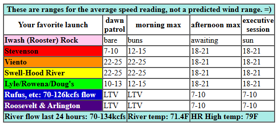
Taking a look at Thursday morning, we’ve got … whitecaps! Pressures at 7am were 30.05/29.94/29.93 for gradients of 0.11 (YES) and 0.01 (not much). Wind at dawn was 21-24mph between Viento and Swell with teens in Hood River and 10-13mph near Stevenson, Mosier, and the Rowena zone. Farther east: light/variable. Let’s call it 22-25mph this morning from Viento to the Hatch with 17-20mph from Hood River to Mosier. Stevenson joins at 18-21mph once the clouds burn back a bit. When they do burn back, the wind may drop to 18-21mph, but it’ll fill in all the way from Stevenson to Doug’s. East of there: light all day. River flow over the last 24 hours was 70-134kcfs, river temp is 71.4F, and high temp forecast is 79F and sunny.
RIVER FLOW FOR SITES BETWEEN AVERY (EAST OF THE DALLES) AND RUFUS: CLICK HERE FOR JOHN DAY DAM FLOW.
RIVER FLOW FOR SITES BETWEEN STEVENSON AND DOUG’S BEACH (WEST OF THE DALLES): CLICK HERE FOR THE DALLES DAM FLOW

tomorrow’s gorge wind forecast
A brief ridge of high pressure takes over on Friday. This results in clear sky across the land. No marine clouds, sorry. West wind will be 11-14mph at dawn from Viento to the Hatch. The wind slowly, ever so slowly builds. By mid afternoon, we’ll have 17-20mph from Stevenson to Doug’s. High temp: 84F.
extended Gorge wind forecast
Saturday also looks sunny all across the land, but a better cross-Cascade temp profile gives us a bit more wind. A front approaching in the afternoon will give the wind a nudge, drive cooler air towards the west side, and also make conditions gusty. Early wind: 17-20mph all the way from Stevenson to Arlington with 12-15mph near Rowena. By mid-morning, we’ll have gusty 20-23mph from Stevenson to Mosier with 17-20mph to the east. Afternoon sees the wind drop to 16-19mph between Stevenson and Hood River as the approaching system disrupts the stabilizing cap. Out east, from Mosier to Arlington, the wind rises to 25-28mph, potentially 27-30mph from Maryhill to Arlington. Remember that 27-30mph on those sensors is more like 19-22mph at Swell. Still, that would be enough. High temp: 80F in Hood River and 86F in the eastern Gorge.
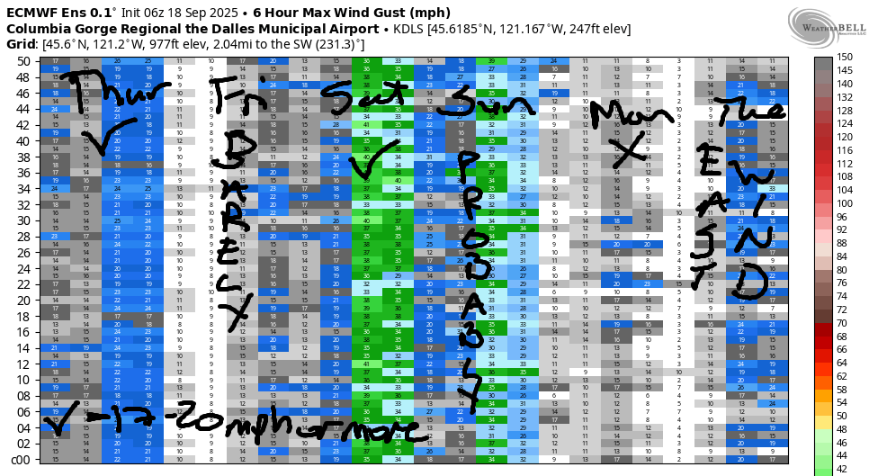
A brief shot of rain early Sunday morning combines with clouds and cooler air for a lesser day. As of this morning, there’s quite a bit of range in the ensembles. Also lacking: agreement between the Euro and GFS. Either way… we should have low to mid 20s from Mosier eastward. Monday: either light/variable wind or east wind. Tuesday: light and variable. Beyond that, model agreement falls apart, so I”ll leave it there for now. Plus, I gotta go. It’s windy!
Was that helpful? I knew it was! Guess what? All of this crucial work – from your personal wind and snow reports to the invaluable TATAS updates – is made possible by my relentless efforts. Maintaining this labor of love isn’t easy. Each daily forecast takes hours. Website hosting, weather model access, and back-end admin work takes time and money. That’s where you come in.
YOUR CONTRIBUTION MAKES A DIFFERENCE
- SUPPORT ACCURATE, HYPER-LOCAL WEATHER FORECASTING
- ENABLE ACCESS FOR ALL, EVEN THOSE WITH LESS MEANS
- SUPPORT A COOL HUMAN WHO WORKS HARD SO YOU CAN PLAY
Take a moment to click one of the buttons below. Donate $19.99 or more (how much does this forecast enhance your life?) and get the email in your inbox. Whether it’s a renewing subscription (auto-renew) or a one-time donation, every contribution makes a real difference. Help me keep this labor of love alive, so we can all continue playing, commuting, and living in the Gorge with peace of mind and the best weather forecasts possible. Thank you!


Hood River, Oregon 97031


JONES BEACH, SAUVIE ISLAND, & COAST FORECAST
Wind northerly unless otherwise indicated. For coast, it’s North/Central/South with the “central” at approximately Florence. Swell forecast from NWS for central coast. Jones: westerly unless otherwise stated. Sauvie Island: northerly unless otherwise stated. Coast Thursday: 20/20-25/30-35, NW swell 8′ at 11 seconds. Friday: 15/15/20-25, NW 6′ @ 10. Saturday: SW 15-20/SW 5-10/N15, NW 5′ @ 12. Jones Thursday: 14-17. Friday: 18-21. Saturday: 7-10. Sauvie Island Thursday: 15-18. Friday: 5-10. Saturday: LTSW.
BARE BONES HOOD RIVER WEATHER FORECAST
Clear sky today. Temps start int the lo w60s and rise to the upper 70s. Moderately strong westerlies. No rainbows. Friday will be sunny. Temps start in the lo w50s and rise to the mid 80s. Moderate westerlies. No rainbows. Saturday will be sunny. Temps start in the mid 50s and rise to 80ish. Moderate to moderately strong westerlies. No rainbows.
TEMIRA’S AWESOME TRAVEL ADVISORY SERVICE – THURSDAY
HYPERLOCAL WEATHER FORECAST FOR THE COLUMBIA GORGE
THE DALLES, HOOD RIVER, WHITE SALMON, TROUT LAKE, STEVENSON, CASCADE LOCKS, PARKDALE, ODELL, HUSUM, BZ, MILL A, WILLARD, GOLDENDALE, RUFUS, ARLINGTON, boardman
Good morning, neighbors! Three days of sun and fun are on tap, and then some of us will see a touch of The Rain on Sunday morning. After that: back to normal, mild, rather dry fallish weather. Signs of a significant pattern change and significant rain are fading from the ensembles; about 85% were on board yesterday, and now about 40-50% are on board. COME ON MA NATURE WE NEED RAIN!
Glenwood this morning
We’ll have no rain today, but we will have a cool morning in Glenwood: it was 44 degrees there to start the day. 4+4 is 8, and that’s this morning’s wake-up hour in Glenwood. Everyone is sleeping in so they can rise after it’s 50 degrees. Down here in the lowlands, I opened my windows at 6am to let in the 62 degree air. It was a warm start in the lowlands today!
Today’s Gorge weather forecast
For the rest of today… the west side started out cloudy, and the rest of us started out clear. Hopefully our minds and hearts will remain as clear as the sky today. Clarity allows us to make wise decisions, and clarity allows us to act from a place of kindness. Good thing the sky is on board today in helping us out with that! Temps today rise to 79F (west) and 85F (The Dalles and desert). West wind will be 20-25mph this morning between Viento and Hood River with 15mph near Mosier. Afternoon wind will be 20mph between Stevenson and Murdoch with less wind to the east and west. Clouds eventually burn off on the west side which results in everyone west of the Cascade Crest suddenly having clear hearts and minds. What a day it will be!
Overnight, stars blaze. Billions of them.
Friday’s Gorge weather forecast
Clear sky Friday morning is forecast all across the land thanks to a brief ridge of high pressure. With light wind early (10-15mph between Viento and Underwood), we’ll have a cool (50-55F) start. That same ridge gives us a warm finish: 85F to the west, 90F in The Dalles, and 85F to the east. West wind rises to 15-20mph between Stevenson and The Dalles in the afternoon with lighter wind to the east. This results in a mass exodus of fishing boats and fishing people from west to east, and this results in a mass exodus of fish. They’re smart, you know!
Saturday’s Gorge weather forecast
Sunshine is forecast all day, all across the land, on Saturday. With a sangha of monks congregating in Underwood, lovingkindness is also in the Gorge forecast. My heart is happy at the thought. Weatherwise, we’ll have 50-60F to start and 80-87F to finish. Fishing? Wind will be 15-20mph from Stevenson to Arlington early (15mph from Lyle to Murdoch). Afternoon: 20-25mph from Stevenson to Arlington rising to 25-30mph from Mosier to Arlington.
Extended Gorge weather forecast
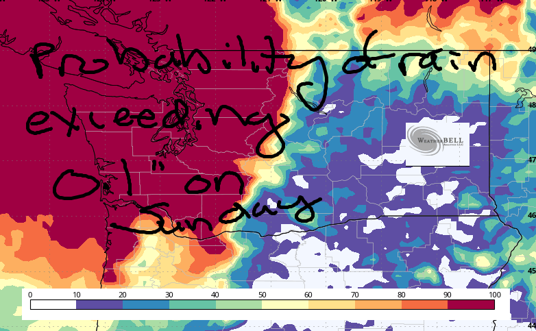
Rain is forecast in the wee hours of Sunday west of The Dalles. Chances of 0.1” or more range from 60% west of Viento to 10% near The Dalles and 100% along the Cascade crest. Chance of 0.5” or more is nil in the lowlands and about 10-20% near Mt. Hood and Mt. Adams. Rain finishes up around sunrise. We’re left with dissipating clouds, 15-20mph west wind, and highs in the 70-79F range.
Monday looks warm (80F) and sunny with light/variable or east wind. Ditto on Tuesday, but add just a couple degrees of warmth. And that, my friends, is enough for now. Safe travels. -TATAS
HEY! DON’T STOP READING! Is this community-focused forecast helpful to you? It sure is! It takes me a couple hours a day to write. Please join your friends and neighbors in contributing to keep it going. Venmo: @thegorgeismygym PayPal: twomirrors@gmail.com USPS: Temira / PO Box 841 / Hood River, Oregon 97031 You can test out the forecast subscription for a few days for free by signing up below. Easy! Do it!
MT HOOD SNOW FORECAST

CURRENTLY ON VACATION. WILL RETURN SOMETIME BEFORE THE START OF SKI SEASON AT MEADOWS, TIMBERLINE AND SKIBOWL. SAME GOES FOR THE NORDIC SKIING SEASON AT MEADOWS AND TEACUP!
