

GORGE WIND FORECAST
If you’re still seeing yesterday’s and it’s after 9am, try opening this in an incognito window AND/OR FLUSHING YOUR CACHE or do a do a hard refresh (Ctrl+Shift+R / Cmd+Shift+R)
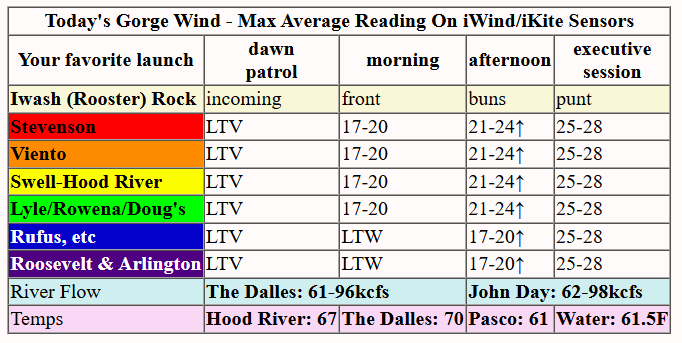
Keep in mind that this forecast attempts to predict what the iKite/iWind sensors will read. Think like a local! All sensors are not equal. Swell reads low. Viento/Arlington/The Wall read high compared to Swell. 30mph at Rufus (The Wall sensor) is about 23-24mph at Swell. 30mph at Swell is about 35-37mph at Rufus/Viento/Arlington. Hope that helps!
SHORT-TERM gorge wind forecast

Hi friends! Today and tomorrow are what you’ve been waiting for if you’ve been waiting for solid westerlies. A cold front swings through on Thursday. Offshore, strong high pressure builds behind it. Setup quality: good! Gorge wind forecast: good! Westerlies extend to Rufus Thursday afternoon. On Friday, early wind will extend into the desert, but the all-day focus will be in the Corridor (Viento to Hood River). Starting Saturday, we’ll have easterlies for a couple days, probably, but uncertainty is actually quite high starting Sunday.
Thursday’s opening shot was gradients of nearly-nothing: 29.88/29.87/29.88 and light/variable wind. As this system, a cold front, approaches the coast, a solid cross-Cascade thermal gradient develops and high pressure builds offshore. By late morning, we’ll have 17-20mph from Stevenson to Hood River. By early afternoon: 21-24mph from Stevenson to Doug’s.
The Hatch may drop off mid-afternoon, but other locations between Stevenson and Doug’s rise to 25-28mph (slight chance of a couple mph more). Rufus builds to 20-23mph. Strong westerlies in the Corridor continue into the evening and overnight. River flow over the last 24 hours was 61-98kcfs, river temp is 61.5F, and high temp forecast is 67F with increasing clouds.

RIVER FLOW FOR SITES BETWEEN AVERY (EAST OF THE DALLES) AND RUFUS: CLICK HERE FOR JOHN DAY DAM FLOW.
RIVER FLOW FOR SITES BETWEEN STEVENSON AND DOUG’S BEACH (WEST OF THE DALLES): CLICK HERE FOR THE DALLES DAM FLOW

LONGER-TERM gorge wind forecast
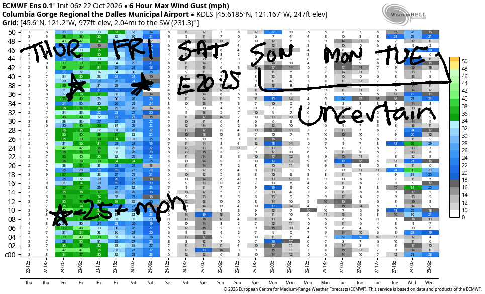
Friday kicks off with solid gradients, but it’s hard to say if the wind will be present at dawn – the colder the morning is, the less likely the westerlies are to show up right away. Morning temp: 39! Anyway, it’s likely we’ll have 22-25mph from Viento to Arlington early in the morning. Looking at the sounding model, I have a sneaking suspicion the wind will be even stronger. Areas east of Doug’s fade by late morning or early afternoon.
While models suggest a die-off, my best guess would be for the wind to hold and potentially build for a few hours late morning. 24-27mph from Stevenson to Mosier is not out of the question. After 2pm, the wind is likely to fade as high pressure builds inland, but we should still end the day with 17-20mph. High temp: just 61 degrees with a few high clouds.
On Saturday, high pressure takes over and turns the wind easterly. We’re likely to see 25mph at Stevenson, Iwash/Rooster, and Viento into early afternoon. By day’s end, the wind falls to 15-20mph at Iwash/Rooster and 15mph at Stevenson. Easterlies rise to 5-10mph near Hood River and 10mph east of The Dalles. High temp: 63 and partly cloudy.
Sunday’s forecast is quite uncertain – models are close to 50/50 on continued dry/high pressure weather or a weather system moving through with rain. Similar uncertainty continues into the extended forecast, so I”ll hold off on making any predictions beyond Saturday for now. But hey, that’s a forecast for three days of wind. Go get some! Hope to see you on the Nch’i Wana soon!
Tip via venmo, cash or check
Want to subscribe to the email version, support Temira, and get the forecast earlier? Click on the blue box up above or use the methods below. Year-round is $29.99 or more if you think it’s worth more. Only need snow or only need wind? Warm season (May-Oct) or cold season (Nov-Apr) is $19.99 or more if you think it’s worth more. Same for the cold season forecast. Thanks for your support!

JONES BEACH, SAUVIE ISLAND, & COAST FORECAST
Wind northerly unless otherwise indicated. For coast, it’s North/Central/South with the “central” at approximately Florence. Swell forecast from NWS for central coast. Jones: westerly unless otherwise stated. Sauvie Island: northerly unless otherwise stated.
Coast Thursday: 20-25/20-25/25-30, NW swell 9′ @ 12 seconds. Friday: 15/15/25-30, NW 10′ @ 10. Saturday: 10/15/20, NW 6′ @ 10. Jones Thursday: 16-19. Friday: LTW. Saturday: LTE. Jones Thursday: 16-19. Friday: LTW. Saturday: LTE. Sauvie Island Thursday: NW 16-19. Friday: 11-14. Saturday: LTN.
BARE BONES HOOD RIVER WEATHER FORECAST
Mostly clear sky this morning. Mostly cloudy later. Temps start in the upper 30s and rise to the upper 60s. Light westerlies early. Strong westerlies later. No rainbows. Friday will be partly cloudy. Temps start in the upper 30s and rise to the low 60s. Moderately strong westerlies. No rainbows. Saturday starts Nothing (clear away from the river) and ends partly to mostly cloudy. Temps start in the low 30s (frost advisory) and end in the low 60s. Light easterlies. No rainbows.
BIKE TRAILS INFO
NEXT WORK PARTY: October 25th and November 8th in Post Canyon with the HRATS.
CLOSED TRAILS: Anything south of the 44 Road due to the Grasshopper Fire / Forest Closure Order: for example – Boulder Lakes, Gunsight, Gumjuwac, Lookout Mountain, 450, Fifteenmile.
TEMIRA’S AWESOME TRAVEL ADVISORY SERVICE
HYPERLOCAL WEATHER FORECAST FOR THE COLUMBIA GORGE
THE DALLES, HOOD RIVER, WHITE SALMON, TROUT LAKE, STEVENSON, CASCADE LOCKS, PARKDALE, ODELL, HUSUM, BZ, MILL A, WILLARD, GOLDENDALE, RUFUS, ARLINGTON, boardman

Good morning, neighbors! The weather’s probably taking a turn for the cooler, but models are quite uncertain about the weather for the next couple of weeks – disregard whatever your phone is telling you about Sunday onward – we’re 60/40 for cooler/wetter or continued dry conditions. Saturday’s before that window of uncertainty, and it’s looking cool enough, calm enough, and possibly clear enough for a widespread frost. Start gathering all your season-end basil and tomatoes and stay tuned!
Thursday starts frosty in Glenwood – 27 degrees. No surprise there. Centerville is 38, Parkdale is 32-43, and Middle Mountain is 50 degrees as I write this. Fun stuff on the schedule today: a cold front approaches from the coast and does 2 (scratch that – 4) exciting things. First thing: strong west wind. Second thing: instability and possible thunderstorms east of Rufus. Third thing: increasing clouds. Fourth thing: Areas west of Hood River could see a trace of drizzle late Thursday into Friday morning. Westerlies build to 25-30mph from Stevenson to Avery this afternoon and fill in all the way out into the desert tonight. It’ll be windy enough that NWS has issued a wind advisory. It’s autumn. Temps are cooler, and vegetation is wetter than it was, but fire danger is still a thing. Be very careful today. High temps: 65 in Stevenson, 67 in Hood River, 70 in The Dalles, and 61 in Pasco.
This weather system swings through tonight. Colder air follows it inland – temps at 850mb (~5000′) drop to 0C. Frosty areas are possible on Friday morning, but most areas will be too windy for frost to develop. Even in the hills, the forecast is W or NW 30-35mph depending on elevation. Morning temps most places: 36-46 with clear sky between Viento and Rufus and clouds west of Viento and east of Rufus. West wind will be 25mph pretty much all day west of The Dalles. It starts at 25mph east of The Dalles and fades. High temps: 59 in Stevenson, 61 in Hood River, 64 in The Dalles, and 66 in Pasco.
If you want frost (it is pretty), Saturday morning carries some possibility for you. Dewpoints will be 20-34 degrees, 850mb temps +6C, the sky will be mostly clear, and the wind will be easterly. Widespread temps under 36 degrees are possible east of Viento, which means widespread frost is possible. A Nothing cloud likely develops right along the Nch’i Wana which would anti-freeze those areas. Afternoon temps rise to 61-65 degrees, warmest in the east-windy zones and also in The Dalles. Easterlies build to 25mph at Iwash (not a rooster) Rock, Stevenson, and Viento with easterlies at 5-10mph east of Hood River and also up in the hills and also in South Wasco County.
Starting Sunday, model agreement falls apart. About 60% of the ensemble members give us cooler, wetter weather. The other 40% keep the weather dry. (see image) As much as I like cool autumn sunshine, we really do need some rain. I’m going to check the “RAIN” box on my ballot. You should also check that box along with checking all the others. Vote! For the love of this country, VOTE! Safe travels. -TATAS
HEY! DON’T STOP READING! Is this community-focused forecast helpful to you? It sure is! It takes me a couple hours a day to write. Please join your friends and neighbors in contributing to keep it going. Venmo: @thegorgeismygym PayPal: twomirrors@gmail.com USPS: Temira / PO Box 841 / Hood River, Oregon 97031
MT HOOD SNOW FORECAST

QR codes and links for end-of-season tips – thank you!!!
Cash/check: Temira – PO BOX 841 – Hood River, Oregon 97031



Leave a Reply