

GORGE WIND FORECAST
If you’re still seeing yesterday’s and it’s after 9am, try opening this in an incognito window
today’s gorge wind forecast
Hi friends! Nice to see so many of you on the river out in the Rufus zone yesterday! Today (Thursday) looks like a decent day on the river. After today, the overall pattern shifts. The setup, while pleasantly cool, isn’t the best setup for wind. Let’s take a look at the details in the TLDR Gorge wind forecast, shall we?
Today started with marine clouds past Hood River. Looking at the Dallesport webcam, it looks like those clouds are all the way to Rowena! Pressures at 7am were 30.04/29.95/29.90 for gradients of 0.09/0.05. Areas east of The Dalles are easiest to predict today: we’ll see a slow build to 28-31mph from Avery to Threemile with max wind after 1pm. Remember that 28-31mph on those eastern Gorge sensors is about equivalent to 19-23mph on the Swell sensor.
The western Gorge, thanks to these morning clouds and an approaching warm front, is a bit trickier. Models suggest we’ll see the Viento-Mosier zone build to 20-23mph by late morning, but that’s dependent on clouds burning back (actually, Viento is over-performing at 26mph right now, probably due to the approaching front). Clouds in Stevenson keep the wind lighter, perhaps 16-19mph, and Lyle-Doug’s, almost always slow to build, does that today with a 15-18mph morning. The Mosier-Doug’s stretch eventually builds to 22-25mph or a touch more, becoming gustier in the afternoon as the front approaches. Stevenson to Hood River may see a period of 22-25mph this afternoon (low probability) before dropping to 14-17mph late afternoon as the offshore front moves closer. River flow over the last 24 hours was 94-183kcfs, river temp is 72.5F (poor salmon), and high temp forecast is 77F for Hood River and 85F for Rufus.
RIVER FLOW FOR SITES BETWEEN AVERY (EAST OF THE DALLES) AND RUFUS: CLICK HERE FOR JOHN DAY DAM FLOW.
RIVER FLOW FOR SITES BETWEEN STEVENSON AND DOUG’S BEACH (WEST OF THE DALLES): CLICK HERE FOR THE DALLES DAM FLOW

tomorrow’s gorge wind forecast
Friday starts out with drizzle on the west side and light to moderate west wind: 10-13mph west of The Dalles and 15-18mph east of The Dalles. That’s probably the max wind we’ll see – models actually take it down a notch in the afternoon. Let’s check in again tomorrow morning and see if that’s still the plan. High temp: 75F for Hood River and 84F for Rufus.
extended Gorge wind forecast
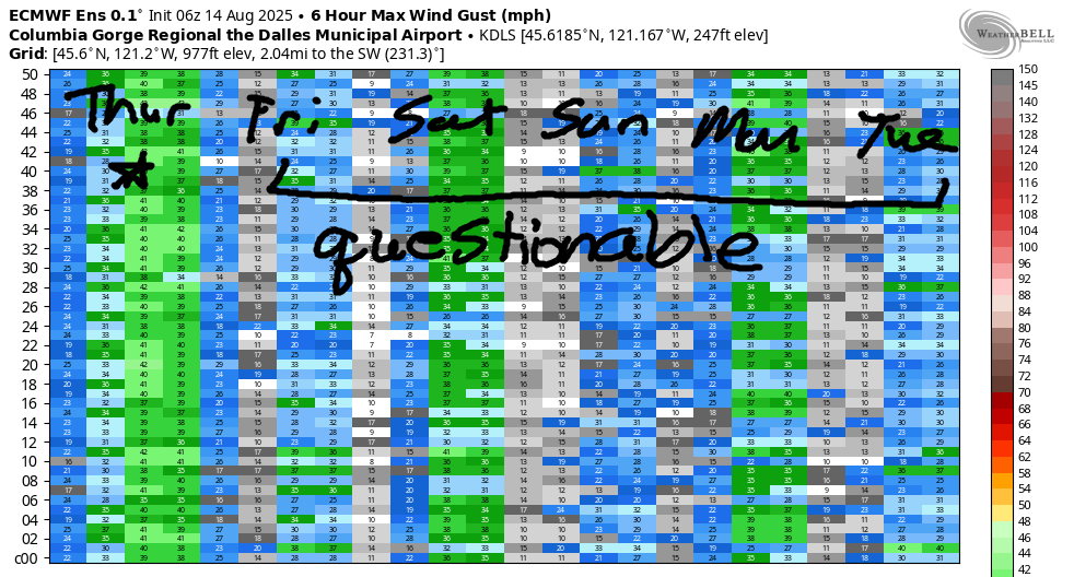
Saturday looks a bit windier, but rain may get in the way of the wind. The wind models suggest a 7-10mph start all through the Gorge. Areas west of The Dalles pick up late morning to 14-17mph. Models suggest afternoon wind will rise to 20-23mph from Mosier to Arlington in the afternoon, but they also hold on to rain east of The Dalles until early to mid afternoon. All that said, there should be enough wind somewhere to get some of you on the river! High temp: 76F for Hood River and 82F for Rufus.
Looking deeper into the future, we have a pattern shift from what we’ve seen most of the summer. Low pressure, or relatively low pressure anyway, sets up off the coast. Troughing (cool air) lingers aloft. It’s looking like we’ll see 17-20mph or more each day, somewhere, but the details are unclear. There are some signs of Monday and Wednesday being stronger than the other days in the week, but none of the days look nuking. For many of you, this is welcome news! All right. I’ll leave it there for now. Lots to do today. Hope to see you on the Nch’i Wana at some point!
Was that helpful? I knew it was! Guess what? All of this crucial work – from your personal wind and snow reports to the invaluable TATAS updates – is made possible by my relentless efforts. Maintaining this labor of love isn’t easy. Each daily forecast takes hours. Website hosting, weather model access, and back-end admin work takes time and money. That’s where you come in.
YOUR CONTRIBUTION MAKES A DIFFERENCE
- SUPPORT ACCURATE, HYPER-LOCAL WEATHER FORECASTING
- ENABLE ACCESS FOR ALL, EVEN THOSE WITH LESS MEANS
- SUPPORT A COOL HUMAN WHO WORKS HARD SO YOU CAN PLAY
Take a moment to click one of the buttons below. Donate $19.99 or more (how much does this forecast enhance your life?) and get the email in your inbox. Whether it’s a renewing subscription (auto-renew) or a one-time donation, every contribution makes a real difference. Help me keep this labor of love alive, so we can all continue playing, commuting, and living in the Gorge with peace of mind and the best weather forecasts possible. Thank you!


Hood River, Oregon 97031


JONES BEACH, SAUVIE ISLAND, & COAST FORECAST
Wind northerly unless otherwise indicated. For coast, it’s North/Central/South with the “central” at approximately Florence. Swell forecast from NWS for central coast. Jones: westerly unless otherwise stated. Sauvie Island: northerly unless otherwise stated. Coast Thursday: SW5/WSW10/N20-25, NW swell 4′ at 9 seconds and SW 2′ @ 15 seconds. Friday: SSW20-25/SW20/LTS, W 4′ @ 7 and SW 2′ @ 14. Saturday: LTW/LTW/N10-15, W 6′ @ 9 and SW 2′ @ 14. Jones Thursday: 7-10. Friday: LTV. Saturday: LTW. Sauvie Island Thursday: 7-10 > 5pm. Friday: LTS. Saturday: LTV.
BARE BONES HOOD RIVER WEATHER FORECAST
Low clouds this morning, clear sky midday, high clouds later. Temps start in the mid 60s and rise to the upper 70s. Moderate to moderately strong westerlies. No rainbows. Friday will be cloudy with mist in the morning. Rain overnight. Temps start in the low 60s and rise to the mid 70s. Muggy. Light to moderate westerlies. 53% chance of rainbows. Saturday will be rainy then partly cloudy. Temps start int the low 60s and rise to the mid 70s. Muggy. Light west wind early. Moderate later. 99% chance of rainbows. Yay!
TEMIRA’S AWESOME TRAVEL ADVISORY SERVICE – THURSDAY 8/14
HYPERLOCAL WEATHER FORECAST FOR THE COLUMBIA GORGE
THE DALLES, HOOD RIVER, WHITE SALMON, TROUT LAKE, STEVENSON, CASCADE LOCKS, PARKDALE, ODELL, HUSUM, BZ, MILL A, WILLARD, GOLDENDALE, RUFUS, ARLINGTON, boardman
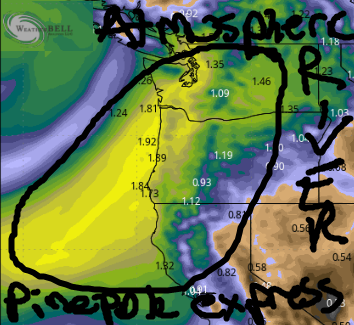
Good morning, neighbors! A lovely stretch of just-about-average temperatures is on tap for us. More importantly, widespread rain is in the cards Friday into Saturday as Mother Nature opens up the moisture tap. The tap taps into an atmospheric river, AKA the Pineapple Express. While the forecast rain totals have backed off a bit, we should see a nice soaking, even in normally dry South Wasco and the inexplicably dry Arlington Triangle.
GLENWOOD THIS MORNING
Checking in with our friends in Glenwood this morning, we have another PERFECT morning: 49 degrees and mostly clear. Everyone in Glenwood has a heart full of gratitude this morning. Why? Because they’re thankful for night after night of cool, sleep-conducive weather. This makes the ice-cold winter mornings worth it! I think it does, anyway, but I’ll let Glenwood residents chime in on that!
TODAY’S GORGE WEATHER FORECAST
The rest of us started out 55-60F (most places) and 65-70F (along the Columbia east of Rowena). Low clouds made it past Hood River this morning. They’ll burn off mid-morning, but they’ll be replaced this afternoon by high clouds from an incoming warm front. West wind today will rise to 20mph between Stevenson and Mosier with 25-30mph from Lyle to Threemile Canyon this afternoon. High temps range from 77F (Hood River) to 82F (The Dalles), and 89F (out where the watermelons live until they get picked and take up residence in your belly).
FRIDAY’S GORGE WEATHER FORECAST
Guess what happens tonight? Some rain! Starting around 2am, Cascade Locks sees a bit. The drizzle spreads east to Rowena in the morning for a couple hours. The rest of Friday looks warm and muggy as an atmospheric river sends record-breaking available moisture this way. That’s total moisture in the air column, which doesn’t necessarily translate to record rain. It’s still cool and awesome and stuff! Expect clouds all day. Expect the dewpoint to be in the 52-60F range, which is gong to feel very muggy. Temps max out in the mid 70s (west), low 80s (The Dalles), and upper 80s (desert). West wind will be 10-15mph west of The Dalles and 15-20mph east of The Dalles in the morning. It drops below 15mph in the afternoon. The next round of rain, a much heavier round of rain, arrives overnight.
SATURDAY’S GORGE WEATHER FORECAST
Starting around 11pm Friday, pouring rain extends from the metro area as far east as Cascade Locks with drizzle to The Dalles. Rain reaches all the way to the Tri-Cities on Saturday morning. By saturday afternoon, everyone west of The Dalles will be dry (but muggy – dewpoint 58-63F) with partly cloudy sky. Rain continues east of Celilo Village into early afternoon. Saturday temps max out in the mid 70s (west) and low 80s (The Dalles eastward). West wind: 5-10mph in the morning. 15-20mph west of Mosier in the afternoon with 20-25mph from Mosier to the Arlington Triangle. Sunday: similar to Saturday.
Rainfall forecast as of this morning: 0.05” to 0.22” for The Dalles and 0.45” to 0.80” near Cascade Locks and in the Cascades. I won’t be surprised if we beat that given the stunning amount of available moisture.
extended gorge weather forecast
Looking into next week, we have relatively mild, near-normal temps through the first half of the week. Models then hint at the weather warming into next weekend with 90-95 degrees for The Dalles next weekend. That said, there’s a lot of range in the temp possibilities. As for rain… this Friday-Saturday rain is probably all we get for the next couple of weeks. So enjoy the fuck out of it! Safe travels. -TATAS
HEY! DON’T STOP READING! Is this community-focused forecast helpful to you? It sure is! It takes me a couple hours a day to write. Please join your friends and neighbors in contributing to keep it going. Venmo: @thegorgeismygym PayPal: twomirrors@gmail.com USPS: Temira / PO Box 841 / Hood River, Oregon 97031 You can test out the forecast subscription for a few days for free by signing up below. Easy! Do it!
