

GORGE WIND FORECAST
If you’re still seeing yesterday’s and it’s after 9am, try opening this in an incognito window
today’s gorge wind forecast
Hi friends! We’re still on track for a windy day today, but the timing has shifted to this afternoon. You’ll recall that previous Gorge wind forecasts for today had a solid marine layer in place this morning. Unfortunately, the arrival time of those clouds are related to an incoming system, and that system has been delayed. It’ll still get windy. Tomorrow: also windy. Moderate easterlies are in the cards for Saturday. On Sunday, a powerful system moves in from the NW. It’s possible we could see periods of strong wind out east, but it’s going to be quite gusty, difficult to predict, and potentially marred by periods of rain. Okay. On to today… before I forget: construction appears to be happening between the White Salmon bridge and the Hatchery with one-way traffic and delays. At least, that’s been the case the last couple of days.
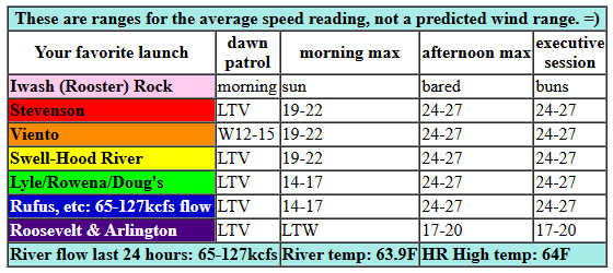
Thursday started off with pressures of 30.23/30.23/30.18. Honestly, I’m not sure those are correct, at least I’m not so sure about that Pasco reading. Anyway, most spots were reading “variable to 5mph” this morning with Viento the star at 14mph. Models drive the wind up by mid-morning: we’ll have 19-22mph from Stevenson to Mosier by 11am. Afternoon wind continues to build and eventually spreads east. By early afternoon, we’ll have 24-27mph from Stevenson to Mosier and 17-20mph from Lyle to Rufus. Those stronger westerlies, 24-27mph, eventually fill in as far east as Rufus. Arlington: 20mph. River flow over the last 24 hours was 65-127kcfs, river temp is 63.9F, and high temp forecast is 64F in Hood River and 69F at Rufus.
RIVER FLOW FOR SITES BETWEEN AVERY (EAST OF THE DALLES) AND RUFUS: CLICK HERE FOR JOHN DAY DAM FLOW.
RIVER FLOW FOR SITES BETWEEN STEVENSON AND DOUG’S BEACH (WEST OF THE DALLES): CLICK HERE FOR THE DALLES DAM FLOW

tomorrow’s gorge wind forecast
Models STILL are in conflict about Friday’s wind. They do agree on low clouds in the morning for the west side with clearing in the afternoon. For now, let’s call it 7-10mph from Stevenson to Doug’s to start the day with 17-20mph from Avery to Arlington. Afternoon wind builds to 21-24mph from Stevenson to Doug’s with 26-29mph from Avery to Threemile. A bit more wind is possible from Avery to Rufus. Maybe. After 3pm, the wind starts to fade. High temp: 62F in Hood River and 67F at Rufus.
extended Gorge wind forecast
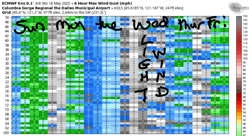
Saturday sees transient high pressure and moderate easterlies ahead of a system approaching the coast. Calm wind early gives way to easterlies at 25mph near Stevenson and Iwash Rock. Home Valley: 20mph. Viento: 15-20mph. After 11am, the wind fades. By mid to late afternoon, Iwash (Rooster) Rock will be light and variable, and Stevenson will be reading 10mph or so. High temp: 65F.
A strong, wet weather system is forecast for Sunday. While the Euro ensemble does suggest we’ll see some wind out east, it’s likely to be quite gusty and inconsistent. Let’s start with the obvious: pouring rain is forecast west of The Dalles. Expect light to moderate westerlies for that zone. Out east, models do have a dry period in the middle of the day. That’s your best shot at wind. Given the presence of strong (40kt) westerlies aloft, the zone from Avery to Rufus is likely to see wind. Gusty mid 20s? Gusty upper 20s? Stronger? Can’t really say at this point. I can say this: Monday and Tuesday look like light west wind days. That’s deep enough into the future for now. Enjoy today and tomorrow. I’ll see you on the Nch’i Wana!
Was that helpful? I knew it was! Guess what? All of this crucial work – from your personal wind and snow reports to the invaluable TATAS updates – is made possible by my relentless efforts. Maintaining this labor of love isn’t easy. Each daily forecast takes hours. Website hosting, weather model access, and back-end admin work takes time and money. That’s where you come in.
YOUR CONTRIBUTION MAKES A DIFFERENCE
- SUPPORT ACCURATE, HYPER-LOCAL WEATHER FORECASTING
- ENABLE ACCESS FOR ALL, EVEN THOSE WITH LESS MEANS
- SUPPORT A COOL HUMAN WHO WORKS HARD SO YOU CAN PLAY
Take a moment to click one of the buttons below. Donate $19.99 or more (how much does this forecast enhance your life?) and get the email in your inbox. Whether it’s a renewing subscription (auto-renew) or a one-time donation, every contribution makes a real difference. Help me keep this labor of love alive, so we can all continue playing, commuting, and living in the Gorge with peace of mind and the best weather forecasts possible. Thank you!


Hood River, Oregon 97031


JONES BEACH, SAUVIE ISLAND, & COAST FORECAST
ON WINTER VACATION. MAY APPEAR RANDOMLY AS NEEDED.
BARE BONES HOOD RIVER WEATHER FORECAST
Clear sky this morning. Mid and high clouds later. Temps start in the upper 30s and rise to the mid 60s. Light westerlies early. Moderately strong westerlies later. No rainbows. Friday will be cloudy then mostly clear. Temps start in the mid 40s and rise to the low 60s. Light westerlies early. Moderately strong later. No rainbows. Saturday will be partly cloudy. Temps start in the upper 30s and rise to the mid 60s. Calm wind early. Light easterlies later. No rainbows.
TEMIRA’S AWESOME TRAVEL ADVISORY SERVICE
HYPERLOCAL WEATHER FORECAST FOR THE COLUMBIA GORGE
THE DALLES, HOOD RIVER, WHITE SALMON, TROUT LAKE, STEVENSON, CASCADE LOCKS, PARKDALE, ODELL, HUSUM, BZ, MILL A, WILLARD, GOLDENDALE, RUFUS, ARLINGTON, boardman
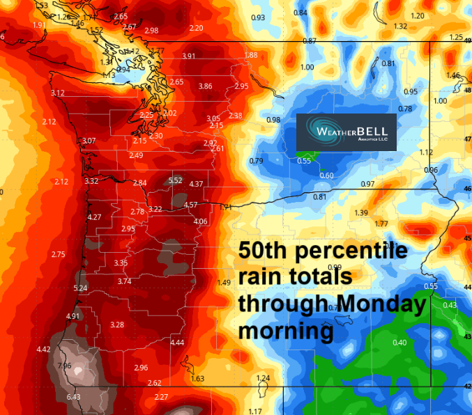
Good morning, neighbors! It’s another beautiful alpenglow morning here in the Gorge, and this is the last completely clear sky morning for a bit. Enjoy it! We’ll stick with (mostly) dry weather until late Saturday or Sunday daytime, when a downpour is in the cards. Dry weather returns by midday Monday, and then we hang out in dry weather for several days. Models are honing in on a very wet period starting in the second half of next week and continuing into the weekend. While models do tend to gravitate away from extreme outcomes over time, the current precipitation forecast for Thursday-Sunday is pretty darn impressive! We’ll keep a close eye on this as we get closer!
Glenwood this morning
Speaking of models changing over time… a few days ago models were certain we’d start today cloudy. Instead, it’s clear where I am, but I suspect there are some Nothing clouds to the east where the relative humidity reading is 100%. Up in Glenwood: clear, calm, and 24 degrees, perfect for ice skating if only it would stop being so damned warm during the day.
Today’s Gorge weather forecast
Rest of today: increasing mid and high clouds this afternoon ahead of a weak approaching system. With sun forecast this morning, temps manage to rise to the mid 60s (west), upper 60s (the Dalles) and mid 60s (desert). West wind builds to 20-25mph between Stevenson and Mosier this morning and 25-30mph between Stevenson and Rufus this afternoon with 20mph near the Arlington Triangle. Overnight: low clouds to the west and mid and high clouds to the east. No stars for you!
Friday’s Gorge weather forecast
Thanks to the clouds, Friday starts warmer: 40-45 degrees. As the sky clears in the afternoon, Sol heats things up. We finish with low 60s to the west and mid to upper 60s from The Dalles east into the desert. West wind sticks around: 10mph west of The Dalles in the morning with 15-20mph east of The Dalles. Afternoon wind rises to 20-25mph from Stevenson to Mosier with 25-30mph from Lyle to Plymouth. The wind fades after 5pm, which is when I’d recommend you go chase down your rubbish bin that probably blew away.
Weekend Gorge weather forecast
A brief break in the weather is in our hand of cards on Saturday morning before clouds arrive in the afternoon ahead of a stronger system. The day starts mostly clear with mid 30s and patchy frost. Afternoon highs rise to 63-67F under partly cloudy sky. East wind is forecast, but it should be (mostly) confined to areas west of Hood River, and it shouldn’t be stronger than 25mph. In other words, it looks like a beautiful day. Mother Nature is bringing good weather in support of the No Kings protests against authoritarianism and brutality against civilians!
Late Saturday into Sunday (timing isn’t clear yet) a downpour arrives from the NW. Models are all over the place on rain amounts; the ECMWF is trending wetter (2” for the Cascades) than the GFS (1” for the Cascades). That said, it’s shaping up to be one of those truly unpleasant drives through the western Gorge. Up in the mountains, strong orographic (terrain) enhancement will result in very stormy conditions above 4000-5000′ starting Sunday. Significant snowfall is likely. Plan your recreation and travel accordingly.
Down here… Sunday looks cool – 55-60F – and quite wet most of the day. There will likely be a period of dry weather east of The Dalles, but the west side can expect an extended soaking. NOT THAT KIND OF SOAKING. We’re talking about the kind of soaking that leads to damp ground, reduced fire danger, and the germination of recently-planted cover crops.
Extended Gorge weather forecast
If we look even deeper into the future, we have several dry days next week followed by surprisingly good model agreement for the following weekend: super wet. As I write that, I find myself getting excited to have some time where I can sit down and get a bunch of indoor tasks done. Well, after going for The Downpour Run, of course. After that, I’ll get those indoor tasks completed. Safe travels. -TATAS
HEY! DON’T STOP READING! Is this community-focused forecast helpful to you? It sure is! It takes me a couple hours a day to write. Please join your friends and neighbors in contributing to keep it going. Venmo: @thegorgeismygym PayPal: twomirrors@gmail.com USPS: Temira / PO Box 841 / Hood River, Oregon 97031 You can test out the forecast subscription for a few days for free by signing up below. Easy! Do it!
MT HOOD SNOW FORECAST

CURRENTLY ON VACATION. WILL RETURN SOMETIME BEFORE THE START OF SKI SEASON AT MEADOWS, TIMBERLINE AND SKIBOWL. SAME GOES FOR THE NORDIC SKIING SEASON AT MEADOWS AND TEACUP!
