

GORGE WIND FORECAST
If you’re still seeing yesterday’s and it’s after 9am, try opening this in an incognito window

today’s gorge wind forecast
Hi friends! It’s Thursday, and marine clouds have pushed well past Hood River to start the day. This gives us a decent day of westerlies… deets to follow. Friday and Saturday both bring moderate westerlies – Friday could beat the models – and then we have our first no-wind day in a long time on Sunday. Westerlies might return late Monday (models are pretty certain they will), and Tuesday looks like The Cooldown You’ve Been Looking For; the Gorge wind forecast looks big and potentially nuking on Tuesday! Models keep wind of some sort in the forecast for the extended period despite uncertainty about the details.
Let’s look at Thursday, shall we? Pressures started with 30.19/30.07/30.05 for gradients of 0.12/0.02. Westerlies were in the 16-20mph range most places to start the day with Hood River and Doug’s under 10mph. Low clouds extended past Hood River, high pressure was offshore, and a front was moving eastward in the offshore waters. Out in the desert: sunshine. The wind will need a little time to warm up from this cool morning; by late morning, we’ll have 20-23mph from Stevenson all the way to Arlington (the Rowena stretch is likely to be even slower to build and will probably stay in the teens through noon).
Afternoon westerlies rise to gusty, up-and-down 21-24 from Stevenson to Hood River with 23-26 from Lyle to Rufus and 20-23mph at Arlington. The wind falls to gusty 17-20 from Stevenson to Hood River mid to late afternoon as that approaching front disrupts things. Between Lyle and Rufus, westerlies rise to gusty 25-28mph. Arlington: still 20-23mph. Executive session wind (after 5pm) looks like 18-23mph from Stevenson to Rufus, strongest between Mosier and Doug’s. River flow over the last 24 hours was 81-159kcfs, river temp is 71.2F, and high temp forecast is 73F for Hood River and 79F for Rufus. Reminder: eastern Gorge sensors read high compared to Swell; 25-28mph at Rufus is approximatley equal to 18-21mph at Swell.
RIVER FLOW FOR SITES BETWEEN AVERY (EAST OF THE DALLES) AND RUFUS: CLICK HERE FOR JOHN DAY DAM FLOW.
RIVER FLOW FOR SITES BETWEEN STEVENSON AND DOUG’S BEACH (WEST OF THE DALLES): CLICK HERE FOR THE DALLES DAM FLOW

tomorrow’s gorge wind forecast
Friday sees low clouds on the west side and sun to the east. A frontal system swings through during the day. Models currently have Dawn Patrol at 17-20mph near Swell. The wind is forecast to drop midday and return in the evening. I suspect, given the cloud forecast, that we’re going to beat that forecast. Expect the wind to be focused between Viento and Mosier. High temp: 81F for Hood River and 88F for Rufus.
extended Gorge wind forecast
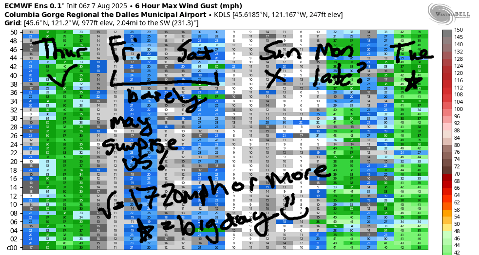
We lose the low clouds on Saturday as high pressure pushes inland. This knocks the wind down a bit. For now, models suggest 16-19mph or so most of the day from Stevenson to Swell with 18-21mph in the afternoon between Stevenson and Mosier or perhaps to Doug’s. High temp: 84F and muggy.
Heat builds across the region on Sunday and sets us up for a light/variable day. Monday brings quite a bit of uncertainty: forecast high temps for The Dalles range from 92-102. Looking at the GFS deterministic, we see troughing (cool air) dropping south from Canada. If it arrives early enough, onshore gradients increase exponentially leading to a very windy afternoon. If it doesn’t happen early enough, don’t’ despair: Tuesday looks like a very windy day as The Cooldown You Were Looking For takes over the Gorge. Beyond that: windy for at least a few more days, most likely. Stay warm today! See you on the Nch’i Wana!
Was that helpful? I knew it was! Guess what? All of this crucial work – from your personal wind and snow reports to the invaluable TATAS updates – is made possible by my relentless efforts. Maintaining this labor of love isn’t easy. Each daily forecast takes hours. Website hosting, weather model access, and back-end admin work takes time and money. That’s where you come in.
YOUR CONTRIBUTION MAKES A DIFFERENCE
- SUPPORT ACCURATE, HYPER-LOCAL WEATHER FORECASTING
- ENABLE ACCESS FOR ALL, EVEN THOSE WITH LESS MEANS
- SUPPORT A COOL HUMAN WHO WORKS HARD SO YOU CAN PLAY
Take a moment to click one of the buttons below. Donate $19.99 or more (how much does this forecast enhance your life?) and get the email in your inbox. Whether it’s a renewing subscription (auto-renew) or a one-time donation, every contribution makes a real difference. Help me keep this labor of love alive, so we can all continue playing, commuting, and living in the Gorge with peace of mind and the best weather forecasts possible. Thank you!


Hood River, Oregon 97031


JONES BEACH, SAUVIE ISLAND, & COAST FORECAST
Wind northerly unless otherwise indicated. For coast, it’s North/Central/South with the “central” at approximately Florence. Swell forecast from NWS for central coast. Jones: westerly unless otherwise stated. Sauvie Island: northerly unless otherwise stated. Coast Thursday: NW5-10/N15-20/N30-35, W swell 5′ at 11 seconds. Friday: NNW15/N20/N30-35, NW 4′ @ 10. Saturday: 20-25/20-25/30-40, NW 5′ @ 10. Jones Thursday: 5-10. Friday: 15-18. Saturday: 18-21. Sauvie Island Thursday: 10-13. Friday: 11-14. Saturday: 14-17.
BARE BONES HOOD RIVER WEATHER FORECAST
Partly cloudy sky all day Thursday. Temps start in the low 60s and rise to the low 70s. Moderate westerlies early. Moderately strong later. No rainbows. Friday will be partly low cloudy then partly high cloudy. Temps start in the low 50s and rise to the low 80s. Moderate westerlies. No rainbows. Saturday will be high overcast. Temps start in the upper 50s and rise to the mid 80s. Muggy. Moderate westerlies. No rainbows.
TEMIRA’S AWESOME TRAVEL ADVISORY SERVICE
HYPERLOCAL WEATHER FORECAST FOR THE COLUMBIA GORGE
THE DALLES, HOOD RIVER, WHITE SALMON, TROUT LAKE, STEVENSON, CASCADE LOCKS, PARKDALE, ODELL, HUSUM, BZ, MILL A, WILLARD, GOLDENDALE, RUFUS, ARLINGTON, boardman
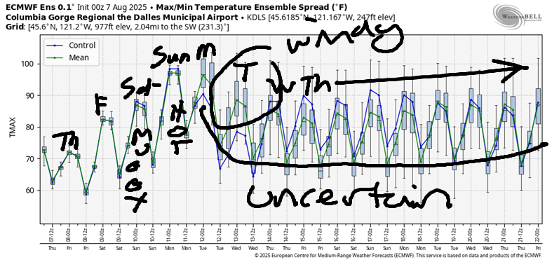
Good morning, neighbors! Yesterday was a fantastic one, at least on the west side: cool and cloudy. Hood River set a new record for rainfall for the date with 0.23”. Timberline Lodge picked up 0.69”, and there’s still a little drizzle falling up there. This is the last of the rain for the next 10-14 days. As a matter of fact, we’ll have the opposite this weekend: heat! And humidity, which is kinda like rain, but it doesn’t fall from the sky.
glenwood this morning
Before diving into the details of the heat (and you should make plans to dive into a cool body of water), we’ll check in with Glenwood. The little hamlet started the day at 49 degrees. Everyone was eating small ham sandwiches, which are hamlettes and often eaten in hamlets. People following religions that don’t consume pork were eating tofurkylettes, which is a new cereal made at the Tofurky factory in Hood River.
today’s gorge weather forecast
The rest of us started the day partly cloudy (west) and sunny (east) with temps near 60. Afternoon brings 73 degrees (Hood River), 79 degrees (The Dalles), and 82 degrees (watermelon grazing zones). Wind will be 15-20mph from Stevenson to Arlington this morning. Afternoon westerlies: 20-25mph from Stevenson to Murdoch with 25-30mph from The Dalles to the Arlington Triangle. Overnight, low clouds return to the west side, but the east side clears. There’s a chance of Aurora Borealis this evening. Not a huge chance, but a chance nonetheless. It might be hard to watch, because the sleeping weather tonight will be so good that you’ll sleep like the dead, who aren’t actually sleeping, because they’re dead. Maybe you’ll sleep like a polar bear hibernating in the 1800s when the weather was colder and the sea ice wasn’t breaking up. Ah, what a sleep that must have been!
friday’s gorge weather forecast
Friday kicks off cloudy to the west and clear to the east. Models suggest west wind will only be 15-20mph and only from Stevenson to The Dalles, but I suspect it’ll be windier than models predict. Either way… temps max out in the low 80s (west) and upper 80s (The Dalles eastward). To be more precise, the high temp forecast for The Dalles is 88 degrees. Looking at the Billboard top 100 from that year, we have “Faith” in the number one spot and “Sweet Child o’ Mine” in the number 5 spot and “Always on My Mind” in the number 80 spot.
saturday’s gorge weather forecast
Temps bump up a few degrees on Saturday thanks to a warmer, muggier start. The dewpoint will be in the mid 50s, which is pretty darn muggy for here. High clouds stick around all day, but it’s not clear how thick they will be. Those clouds are like your average pen*s – you don’t know how thick it will be until it thickens! One thing won’t be clear on Saturday: the sky. This thing is possible: a pretty sunrise. Also possible: a pretty sunset. Temps max out around 84 (Hood River, number one song “When Doves Cry”) and 91 (The Dalles eastward, “Everything I do, I do it for you”). West wind will be 15-20mph all day between Stevenson and Hood river and 15-20mph in the afternoon as far east as The Dalles.
sunday’s gorge weather forecast
Sunday looks hot and muggy with highs in the mid 90s. No wind will ruffle your feathers, or at least not very much wind. Uncertainty blossoms on Monday. High temp range for The Dalles is 92-102F. Clearer signs of cooling are present on Tuesday, which means we’re likely to see a very, very windy day; highs will be near 90 (west) and 100 (desert). Beyond Tuesday, there’s a lot of uncertainty in the models – each day has about 10 degrees of range in the possible high temps. It does look windy all week, so take advantage of no-wind Sunday to get some no-wind stuff done. Safe travels. -TATAS
HEY! DON’T STOP READING! Is this community-focused forecast helpful to you? It sure is! It takes me a couple hours a day to write. Please join your friends and neighbors in contributing to keep it going. Venmo: @thegorgeismygym PayPal: twomirrors@gmail.com USPS: Temira / PO Box 841 / Hood River, Oregon 97031 You can test out the forecast subscription for a few days for free by signing up below. Easy! Do it!
