

GORGE WIND FORECAST
If you’re still seeing yesterday’s and it’s after 9am, try opening this in an incognito window
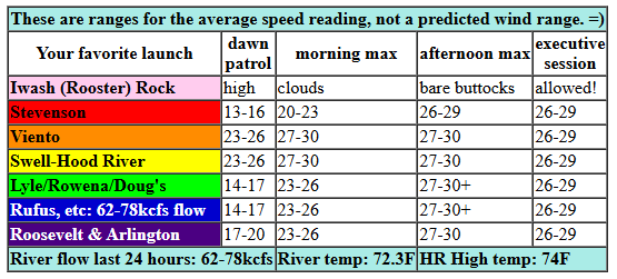
today’s gorge wind forecast
Hi friends! Well… yesterday sure out-performed the models. I had to work yesterday afternoon and couldn’t join the fun, but I did take a look at the later model runs: still no sign of nukage. It’s like the entire gradient got squished between Stevenson and Mosier (it was only 0.13)! Looking at this morning, we have a more obvious strong wind day. Ditto tomorrow. Clarity lessens for the weekend when we have our first strong frontal system of the season. Next week still has some uncertainty, but the general picture currently looks warm and dry with easterlies.
Thursday morning pressures started with 30.00/29.89/29.86 for gradients of 0.11/0.03. Marine clouds were stacked up along the Cascades, and the forecast is for them to stay there all day. Offshore: moderate high pressure. Idaho: low pressure. Instability: confined to the eastern Gorge. Wind was 17-20mph from Viento to the Hatch to start the day (it jumped to 22-25mph while I was writing this!) with 13-16mph at Stevenson, the Rowena zone, The Wall, and also Arlington. Give it a few hours, and we’ll have 27-30mph from Stevenson to Mosier.
By early afternoon, we’ll have 27-30mph from Stevenson to Rufus. Afternoon wind speed could rise to 30-33mph between Lyle and Rufus with 26-29mph at Arlington. Keep the desert instability in mind when choosing your spot today – it could affect wind quality and speed. With the marine clouds locked in all day, the wind holds all day all through the Gorge. Today’s Executive Session looks like 26-29mph all the way from Stevenson to Arlington. The only laggard spot today could be Stevenson if the clouds don’t burn off there at all. River flow over the last 24 hours was 62-78kcfs, river temp is 72.3F, and high temp forecast is 74F for Hood River and 81F for Rufus.
RIVER FLOW FOR SITES BETWEEN AVERY (EAST OF THE DALLES) AND RUFUS: CLICK HERE FOR JOHN DAY DAM FLOW.
RIVER FLOW FOR SITES BETWEEN STEVENSON AND DOUG’S BEACH (WEST OF THE DALLES): CLICK HERE FOR THE DALLES DAM FLOW

tomorrow’s gorge wind forecast
Friday starts off with deep marine clouds on the west side, sun to the east, and a respectable Dawn Patrol: 22-25mph from Viento to Mosier. Mid-morning wind rises to 26-29mph from Viento to Mosier with 17-20mph near Rowena and 11-14mph east of Rowena to Arlington. Stevenson, again, takes its time and doesn’t really fire up until the clouds burn off. As the sky clears in the afternoon, as ridging builds in, westerlies drop to 22-25mph and fill in all the way from Stevenson to Rufus. Arlington: 20-23mph. Temps: 76F for Hood River and 83F out east.
extended Gorge wind forecast
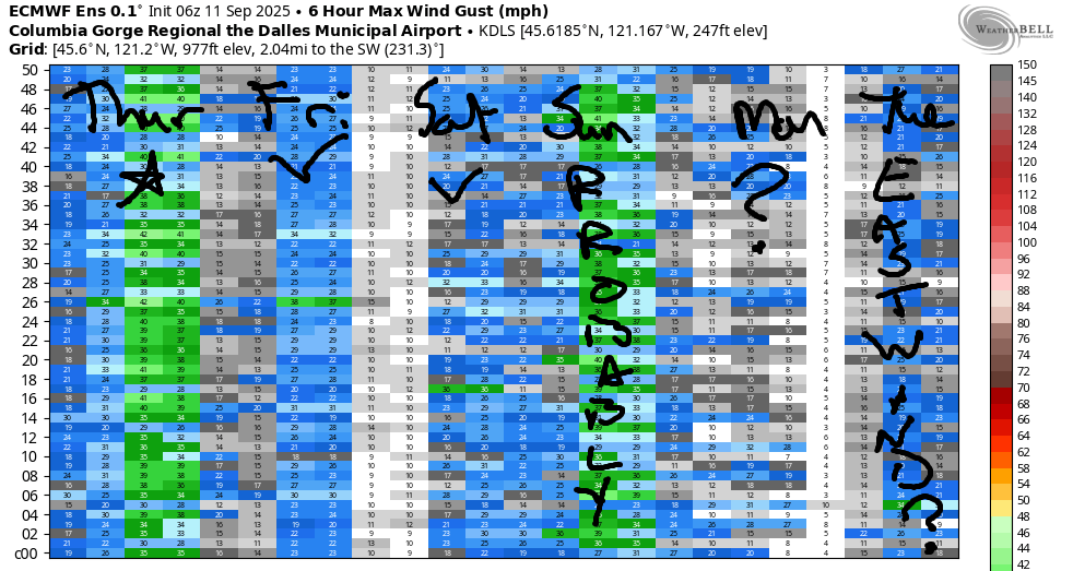
Ridging on Saturday morning sets us up with clear sky all across the region. A low pressure system approaches the coast during the day. This isn’t a great setup, but still looks to bring enough wind: 9-12mph to start from Stevenson to the White Salmon Bridge (this will make the fishing people happy for once). Afternoon, as a front approaches, brings 18-21mph from Stevenson to Rufus with 15-18mph at Arlington. Expect gustiness. High temp: 82-88F under sunny sky.
Rain is forecast on Sunday, but the extent and duration is unclear. As of right now, models suggest 19-23mph in the eastern Gorge. On Monday, the forecast is currently 17-20mph somewhere. Starting Tuesday, models are hinting at our first extended period of east wind as ridging builds over the region and a heat low sets up on the west side. This is a pretty typical September setup, but that doesn’t mean it’s guaranteed; we’ll keep an eye on it. As I said before, I’ll be gone Friday-Monday, but I’ll try and get out a wind forecast, if not the entire forecast, while I’m gone. See you on the Nch’i Wana!
JONES BEACH, SAUVIE ISLAND, & COAST FORECAST
Wind northerly unless otherwise indicated. For coast, it’s North/Central/South with the “central” at approximately Florence. Swell forecast from NWS for central coast. Jones: westerly unless otherwise stated. Sauvie Island: northerly unless otherwise stated. Coast Thursday: LTNW/LTNW/N20, NW swell 3′ at 12 seconds. Friday: N5-10/N15/20-25, NW 6′ @ 13 and SW 2′ @ 14. Saturday: SW15/SW15/S15, W 6′ @ 12 and SW 2′ @ 15. Jones Thursday: 20-23. Friday: 7-10. Saturday: 5-10. Sauvie Island Thursday: 5-10 > 5pm. Friday: LTN. Saturday: LTSW.
BARE BONES HOOD RIVER WEATHER FORECAST
Mostly clear sky this morning. Ditto this afternoon. Temps start in the mid 60s and rise to the mid 70s (windows open all day long). Strong to nuking westerlies. No rainbows. Friday will be mostly clear then clear. Temps start in the upper 50s and rise to the mid 70s. Moderately strong to strong westerlies. No rainbows. Saturday will be mostly clear then high cloudy late with rain possible overnight. Temps start in the mid 50s and rise to the low 80s. Moderate westerlies. No rainbows.
TEMIRA’S AWESOME TRAVEL ADVISORY SERVICE – THURSDAY
HYPERLOCAL WEATHER FORECAST FOR THE COLUMBIA GORGE
THE DALLES, HOOD RIVER, WHITE SALMON, TROUT LAKE, STEVENSON, CASCADE LOCKS, PARKDALE, ODELL, HUSUM, BZ, MILL A, WILLARD, GOLDENDALE, RUFUS, ARLINGTON, boardman
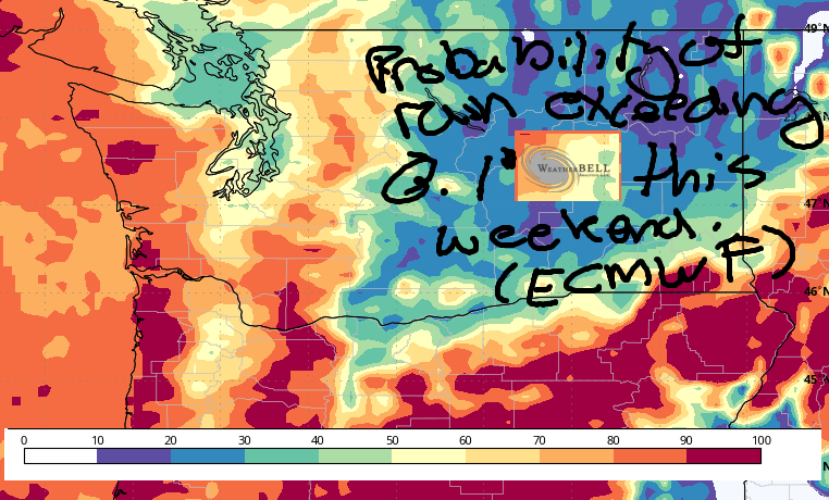
Good morning, neighbors! It’s Thursday, and the Gorge is going to do that thing it used to do all the time: cloudy in the west, sunny to the east, and very, very windy. Please do not start a fire today. We’ll continue with this sort of weather tomorrow, see some warming on Saturday, and maybe get some rain on Sunday morning. More on that later. Models are hinting at a return to dry, warm, low-humidity (finally, bye-bye mugginess) weather next week along with a switch in wind direction to easterly (which makes for better fishing to the east of Hood River than as of late!) Before I forget: THE DECREPIT OLD BRIDGE IS CLOSED 10-11AM TODAY.
Glenwood this morning
Looking at today… we have a 50 degree start in Glenwood. Looking ahead a few days, 850mb temps drop to 10C with potentially clear sky Monday morning, which could result in Glenwood dropping below 40F. SO EXCITING! Still no sign of first frost there. Or here. Or there. Or wherever you are. Speaking of first frost (frost can happen above 32F, to be clear), the first Hood River low below 32F is 9/13/1970, when the temp dropped to 30F and all the gardeners and orchardists cried.
Speaking of cold, I wasn’t going to check the records, but then I did since it was reading 65F at HRW. The record high-low in Hood River this morning is a here 59F. As of the time I was typing this, HOXO was reading 64F. THE SUSPENSE IS KILLING ME.
Today’s Gorge weather forecast
For the rest of today, clouds stick around a looooooooong time west of Hood River. To the east: sunshine. This results in blasting west wind, 30mph average speeds, from Stevenson all the way to Rufus for sure and Arlington almost certainly. Temps max out in the mid 70s to the west, near 80 in The Dalles and 85F out in the desert where maybe someone is growing a watermelon bigger than mine and maybe not (mine, named “Maude-A-Melon”) is pretty damned big.
Friday’s Gorge weather forecast
Friday starts out a lot like Thursday: clouds to the west, sun to the east, lots of wind. Clouds eventually burn off, and we’re all left sunny. Wind will be 20-25mph between Viento and Mosier early with 15-20mph between Lyle and Arlington. Afternoon wind rises to 25-30mph from Stevenson to Rufus with 20mph near Arlington. Temps: mid 70s to the west and mid 80s to the east. 83F in The Dalles, which splits the difference in temps but always picks up the bill for dinner.
Saturday’s Gorge weather forecast
Sunshine takes over on Saturday as a brief ridge (warmer, less humid) settles in. Low to mid 50s start the day (thanks, lower humidity and better radiational cooling). Finish: 82F to the west, 88F in The Dalles, 86F in the desert. Wind will be 5-10mph to start and 15-20mph to finish, and it’ll spread all the way from Stevenson to Arlington in the afternoon ahead of an approaching weather system.
Extended Gorge weather forecast
Know what that system might or might not do early on Sunday morning? RAIN! Models are all over the place on rain amounts. In our favor: plentiful available moisture with the PWAT over 1.0”, early-morning timing of the system, the hope of the 80,000+ people living here… hope helps, you know! As of this morning, the GFS is wetter than the Euro (ithe GFS does tend to have a moisture bias). For Cascade Locks, the GFS says 0.2” to 0.5” early Sunday morning. For The Dalles: trace to 0.05”. Euro is about the same for The Dalles but only has 0.1” to 0.25” for Cascade Locks. Fingers crossed for the most rain possible. Duration of rain is unclear as of now. What is clear is that temps will be cooler, but still rather warm for a rainy day: 70F to the west, 75F for The Dalles, 78F in the desert.
Looking at next week… Monday’s a transition day. Starting Tuesday, models hint at ridging (dry, warm weather) settling in. If the current forecast holds, we’ll end up with a standard-issue Gorge September week: sunny, dry, with east wind. With temps forecast to be 80+ degrees, it’ll be good weather to go to the East Wind Drive-In. Because the east wind will be blowing. One other thing: this setup tends to be very low humidity, and low-humidity nights tend to be chilly. Upcoming: one hell of a good week for sleeping. Safe travels. -TATAS
HEY! DON’T STOP READING! Is this community-focused forecast helpful to you? It sure is! It takes me a couple hours a day to write. Please join your friends and neighbors in contributing to keep it going. Venmo: @thegorgeismygym PayPal: twomirrors@gmail.com USPS: Temira / PO Box 841 / Hood River, Oregon 97031 You can test out the forecast subscription for a few days for free by signing up below. Easy! Do it!
MT HOOD SNOW FORECAST

CURRENTLY ON VACATION. WILL RETURN SOMETIME BEFORE THE START OF SKI SEASON AT MEADOWS, TIMBERLINE AND SKIBOWL. SAME GOES FOR THE NORDIC SKIING SEASON AT MEADOWS AND TEACUP!
