

GORGE WIND FORECAST
today’s gorge wind forecast
Hi friends! Strong wind continues today and tomorrow, and then we’ll have lesser wind, but still enough, over the weekend. Looking at next week, models generally agree on troughing (cooler) and some weak weather systems. That impacts the Gorge wind forecast by bringing in moving parts for higher uncertainty. It’ll still be breezy, but we’ll lose the classic Gorge setup of offshore high pressure and inland heat. Result: lighter wind, which might be a boon to some of you! Given all this wind, the fire situation is concerning. Be aware. As of this morning, both SR-14 and I-84 have reopened. Rowena sits within the level 3 evac zone and is not an option for windsports today. As you’re out and about today, keep the evacuated folks in your hearts and minds. And stay aware – any fires that are started today will increase in size quickly. Know your escape route and have a plan.
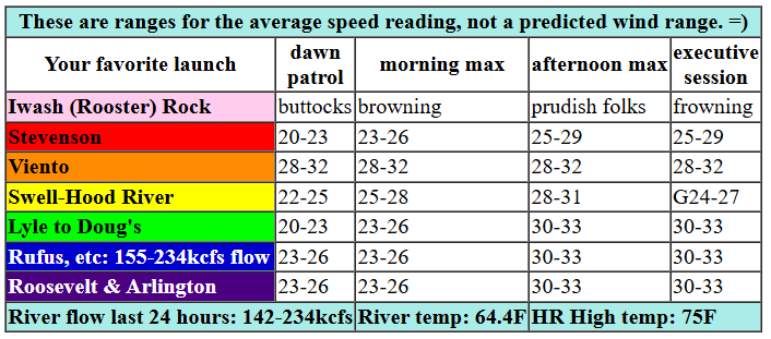
It’s Thursday, and you’ll get no break from windsports unless you create one yourself. Early pressures were 30.09/29.92/29.85 for gradients of 0.16/0.08. That indicates a good day anywhere from (at least) Stevenson to Rufus. At 6am, Viento was reading 33 on the iWind/iKite sensors, Swell was reading 26, and areas east of Mosier were generally at 20-23mph. Expect a quick build today to 27-30 from Viento to Mosier with Stevenson lagging a bit behind. By afternoon, we’ll have 27-30 from Stevenson to Hood River with 30-33 from Mosier to Arlington and 27-30 at Threemile. River flow over the last 24 hours was 142-234kcfs (155-234kcfs at Rufus), river temp is 64.4F, and high temp forecast is 75F for Hood River and 81F for Arlington.

tomorrow’s gorge wind forecast
Friday sees a weak system move inland during the morning hours. This is going to disrupt the wind field a little, but it’s also going to send reinforcing cold air into the west side of the state. This makes for tricky forecasting. For now, I’m going with 23-26 to start from Viento to Doug’s with 17-20 at Stevenson and Avery. As the system moves in, the Stevenson to Doug’s (or maybe Viento to Doug’s if Stevenson ends up cloud) zone rises to 27-30. Avery: 23-26. Rufus: 17-20. Afternoon wind builds to 25-28 from Avery to Arlington and probably drops to gusty 22-26 from Stevenson to Hood River. High temp: 71F for Hood River and 77F for Arlington.
extended Gorge wind forecast
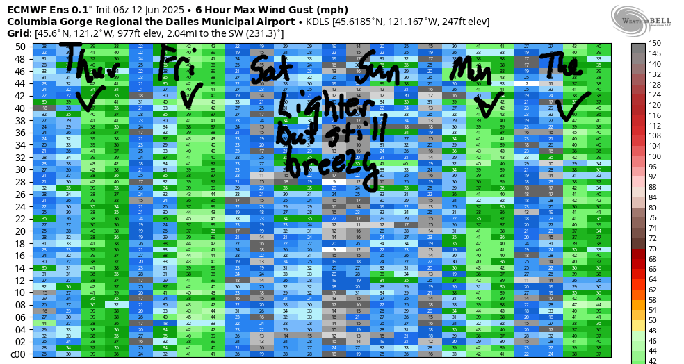
Saturday and Sunday both look like 21-24. Most likely, that wind will focus on Stevenson-Mosier in the morning and the Rowena stretch of the river in the afternoon. Stronger westerlies are forecast to start next week, but there will be lots of moving parts. In response, the wind turns gustier. Have a safe day on the river today. See you out there!
Was that helpful? I knew it was! Guess what? All of this crucial work – from your personal wind and snow reports to the invaluable TATAS updates – is made possible by my relentless efforts. Maintaining this labor of love isn’t easy. Each daily forecast takes hours. Website hosting, weather model access, and back-end admin work takes time and money. That’s where you come in.
YOUR CONTRIBUTION MAKES A DIFFERENCE
- SUPPORT ACCURATE, HYPER-LOCAL WEATHER FORECASTING
- ENABLE ACCESS FOR ALL, EVEN THOSE WITH LESS MEANS
- SUPPORT A COOL HUMAN WHO WORKS HARD SO YOU CAN PLAY
Take a moment to click one of the buttons below. Donate $19.99 or more (how much does this forecast enhance your life?) and get the email in your inbox. Whether it’s a renewing subscription (auto-renew) or a one-time donation, every contribution makes a real difference. Help me keep this labor of love alive, so we can all continue playing, commuting, and living in the Gorge with peace of mind and the best weather forecasts possible. Thank you!


Hood River, Oregon 97031


JONES BEACH, SAUVIE ISLAND, & COAST FORECAST
Wind northerly unless otherwise indicated. For coast, it’s North/Central/South with the “central” at approximately Florence. Swell forecast from NWS for central coast. Jones: westerly unless otherwise stated. Sauvie Island: northerly unless otherwise stated. Thursday: 10-15/15-20/30-35, NW swell 6′ at 9 seconds and S 2′ @ 15 seconds. Friday: 15/15-20/30-35, NW 5′ @ 8 and SW 2′ @ 14. Saturday: 20/20/25-30, NW 5′ @ 7. Jones Thursday: 22-25. Friday: 17-20. Saturday: 17-20. Sauvie Island Thursday: 16-19. Friday: 11-14. Saturday: 10-13.
BARE BONES HOOD RIVER WEATHER FORECAST
Clear sky this morning adds high clouds midday and turns clear again later. Temps star tint he mid 50s and rise to the mid 70s. Strong to very strong westerlies. No rainbows. Friday will be partly cloudy. Temps start in the upper 40s and rise to the low 70s. Strong westerlies. No rainbows. Saturday will be sunny then partly high overcast. Temps start in the upper 40s and rise to the upper 70s. Moderate to moderately strong westerlies. No rainbows.
TEMIRA’S AWESOME TRAVEL ADVISORY SERVICE
HYPERLOCAL WEATHER FORECAST FOR THE COLUMBIA GORGE
THE DALLES, HOOD RIVER, WHITE SALMON, TROUT LAKE, STEVENSON, CASCADE LOCKS, PARKDALE, ODELL, HUSUM, BZ, MILL A, WILLARD, GOLDENDALE, RUFUS, ARLINGTON, boardman
Good morning, neighbors! Let’s start this morning by sending well wishes to our neighbors and friends who are under evacuation orders. Let’s also send some kindness, gratitude and goodwill to the folks fighting the Rowena Fire. Big thanks to the fire crews who managed to quickly contain the fires on the WA side. Also thanks to everyone who did their part yesterday by not doing fire-causing activities. Trains, you did poorly yesterday. In travel news: as of this morning, both I-84 and SR-14 have reopened.
today’s gorge weather forecast and glenwood’s start to the day
Today will be another windy, dry day, so let’s continue to be vigilant.
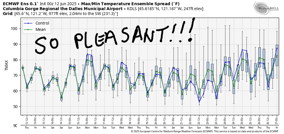
But first, let’s check in with Glenwood. Brr. It’s 41 degrees there. Here in Hood River at my house, it’s 54 degrees, cool enough that I’m risking baking a blueberry buckle to share with my Wind Johnnie friends. Temps rise to the mid 70s (west) and low 80s (east) today. West wind will be 30mph from Stevenson to Mosier this morning and 20-25mph east of Mosier to Arlington. Afternoon wind rises to 30-35mph all the way from Stevenson to Threemile Canyon this afternoon. You will not escape the wind today. No, you will not.
friday’s gorge weather forecast
Temps fall into the upper 40s tonight for most of us. If Glenwood really steps up, they could fall below 40. What a great night for sleeping! As a system moves inland on Friday, clouds stack up against the Cascades. Some clouds even make it east of the Cascade in the afternoon! But there won’t be any rain. Nope. West wind will be 25-30 mph pretty much all day all the way from Stevenson to the Arlington Triangle. High temps make it to the low 70s (west) and upper 70s (east).
the weekend in the gorge
For the weekend, we have slightly warmer and somewhat less windy weather. Temps max out around 80 degrees, and the wind will be 20mph or so both days. Coolish, breezy weather continues next week. There’s a slight chance of light drizzle in the Tuesday-Wednesday timeframe, potentially as far east as Mosier. Let’s take a closer look at this tomorrow, as that drizzle could have an impact on our cherry farmer friends. As of right now, models suggest less than 0.1” rain accompanied by relatively cool temps and breezy westerlies. Let’s dive in deeper into the deets as we get closer, okay? Be kind out there today. Safe travels. -TATAS
HEY! DON’T STOP READING! Is this community-focused forecast helpful to you? It sure is! It takes me a couple hours a day to write. Please join your friends and neighbors in contributing to keep it going. Venmo: @thegorgeismygym PayPal: twomirrors@gmail.com USPS: Temira / PO Box 841 / Hood River, Oregon 97031 You can test out the forecast subscription for a few days for free by signing up below. Easy! Do it!
