

MT HOOD SNOW FORECAST

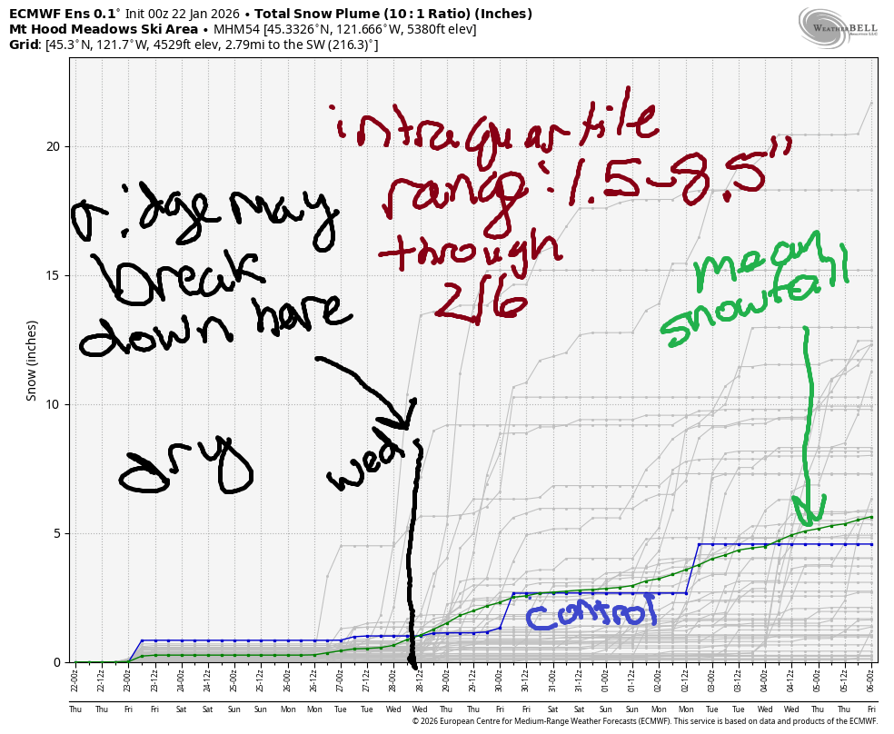
Hey skiers and snowboarders. The weather remains disconcertingly quiet for January all the way through the end of January, and the start of February is tilting towards “quiet” as well. The intraquartile range for snowfall, 25th percentile through 75th percentile, is down to 1.5” to 8.5” of snow through the 6th of February. Generally speaking, we’ll stay dry through the middle of next week, with a short period of sub-freezing temps on the mountain early next week. Earliest return of precip is probably the middle of next week, and temps are currently forecast to be too warm for snow. This winter… something else… stunning…
Short term Mt Hood snow forecast
Thursday is starting off with high clouds, light wind, and very low humidity of 16-31%. This makes for efficient radiational cooling and is aiding a massive inversion: it’s 36F at 6540′, and it’s 8F down in the valley where Teacup is located. Clouds increase today as a near-nothing of a weather system brushes the region. Today’s free air freezing level starts at 8000′, falls to 6000′, and drops to 0′ overnight as colder air arrives from the east. Temps at 5000′ land right around 32F this afternoon. Wind will be light/variable this morning, NW 15 this afternoon, and NE 10 overnight.
On Friday, a few morning high clouds give way to afternoon sunshine. The free air freezing level will be 0-500′ all day as cold air pours in from the east side. Temps at 5000′ will be right around freezing. Wind will be NE 10 in the morning, E 30 in the afternoon, and E 15 overnight. East wind at 30mph is sometimes enough to cause lift issues at Timberline (generally not at Meadows), so check their website before heading there.
Extended Mt Hood Snow Forecast
Saturday will be sunny. The free air freezing level (FAF) starts at 0′ and slowly rises to 6000′. Temps max out in the mid 30s at 5000′. Wind will be E 15 in the morning, light/variable in the afternoon, and SW 5-10 overnight. Sunday brings clear sky early and high clouds later. The FAF will be around 6000′ all day with temps rising to the mid/upper 30s at 5000′. Wind will be light SW in the morning, W 15 in the afternoon, and W 30 overnight. Still no precip!
Dry weather continues for the early part of next week. Models currently break down this beastly high pressure ridge (probably) in the middle of next week. Even so, temps on the slopes look to remain above freezing. Wow. Just wow. Once again, I point you towards skate skiing – Meadows does reasonably priced group lessons – and the skating has been phenomenal day after day. Hope to see you out there!
Was that helpful? I knew it was! Guess what? All of this crucial work – from your personal wind and snow reports to the invaluable TATAS updates – is made possible by my relentless efforts. Maintaining this labor of love isn’t easy. Each daily forecast takes hours. Website hosting, weather model access, and back-end admin work takes time and money. That’s where you come in.
YOUR CONTRIBUTION MAKES A DIFFERENCE
- SUPPORT ACCURATE, HYPER-LOCAL WEATHER FORECASTING
- ENABLE ACCESS FOR ALL, EVEN THOSE WITH LESS MEANS
- SUPPORT A COOL HUMAN WHO WORKS HARD SO YOU CAN PLAY
Take a moment to click one of the buttons below. Donate $19.99 or more (how much does this forecast enhance your life?) and get the email in your inbox. Whether it’s a renewing subscription (auto-renew) or a one-time donation, every contribution makes a real difference. Help me keep this labor of love alive, so we can all continue playing, commuting, and living in the Gorge with peace of mind and the best weather forecasts possible. Thank you!


Hood River, Oregon 97031


GORGE WIND FORECAST
If you’re still seeing yesterday’s and it’s after 9am, try opening this in an incognito window
SHORT-TERM gorge wind forecast
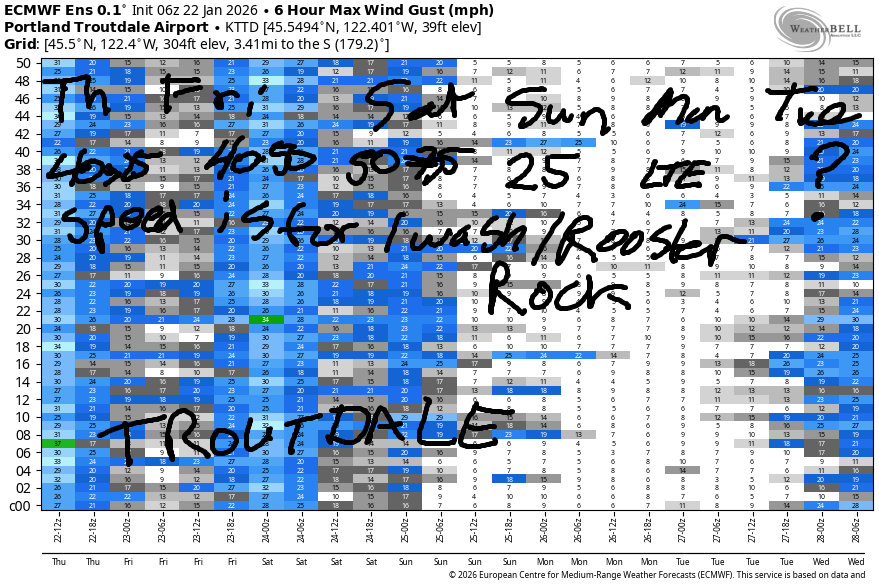
Hi friends! The barrage of easterlies continues! Thursday won’t be quite as strong as we’ve seen over the last few days, but it’s still windy out there. Pressures prior to dawn were 30.24/30.38/30.37. Easterlies were reading 42mph at Iwash, 25-30mph at Stevenson, and around 15mph at Viento. The wind will drop off this afternoon; Iwash finishes the day at 25-30mph, and Stevenson lands at 20mph. River flow over the last 24 hours was 172-210kcfs, river temp is 42.3F, and high temp forecast is 36F and mostly cloudy in the windy zones by afternoon.
Friday starts with 40mph at Iwash and 25-30mph at Stevenson. Midday bring s40-50mph at Iwash and 35-40mph at Stevenson. Afternoon wind fades to 25mph at Stevenson and 35-40mph at Iwash. High temp: 39F with clouds in the morning and sunshine in the afternoon.
RIVER FLOW FOR SITES BETWEEN AVERY (EAST OF THE DALLES) AND RUFUS: CLICK HERE FOR JOHN DAY DAM FLOW.
RIVER FLOW FOR SITES BETWEEN STEVENSON AND DOUG’S BEACH (WEST OF THE DALLES): CLICK HERE FOR THE DALLES DAM FLOW

LONGER-TERM gorge wind forecast
Colder easterlies are forecast on Saturday, at least to start. Iwash’s opening play will be 50mph. It ends the day at 35-40mph. Stevenson starts with 25mph, rises to 35mph, and fades to 30mph. High temp: 39F after a sub-freezing start. Clear sky.
On Sunday, easterlies are likely to be lesser – models this morning give us 25-30mph at Iwash and less at Stevenson. Models currently call for either light easterlies or light/variable wind on Monday. Looking deeper into the future, there’s no sign of westerlies. Most members of the ensembles like the idea of easterlies returning in the middle of next week. Stay safe out there. Dress extra-warmly, have an emergency plan, and keep an eye on your buddies.
BARE BONES HOOD RIVER WEATHER FORECAST
Nothing this morning. Nothing plus mid-level clouds this afternoon. Even darker! Temps start in the low 30s and rise to the mid 30s. Light to moderate easterlies. No rainbows. Friday will be Nothing plus mid clouds then mostly clear. Please let it be so. Temps start in the upper 20s and rise to the upper 30s. Light to moderate easterlies. No rainbows. Saturday will be Nothing near the river then clear. Temps start in the low-mid 20s and rise to the upper 30s. Light to moderate easterlies. No rainbows.
TEMIRA’S AWESOME TRAVEL ADVISORY SERVICE
HYPERLOCAL WEATHER FORECAST FOR THE COLUMBIA GORGE
THE DALLES, HOOD RIVER, WHITE SALMON, TROUT LAKE, STEVENSON, CASCADE LOCKS, PARKDALE, ODELL, HUSUM, BZ, MILL A, WILLARD, GOLDENDALE, RUFUS, ARLINGTON, boardman
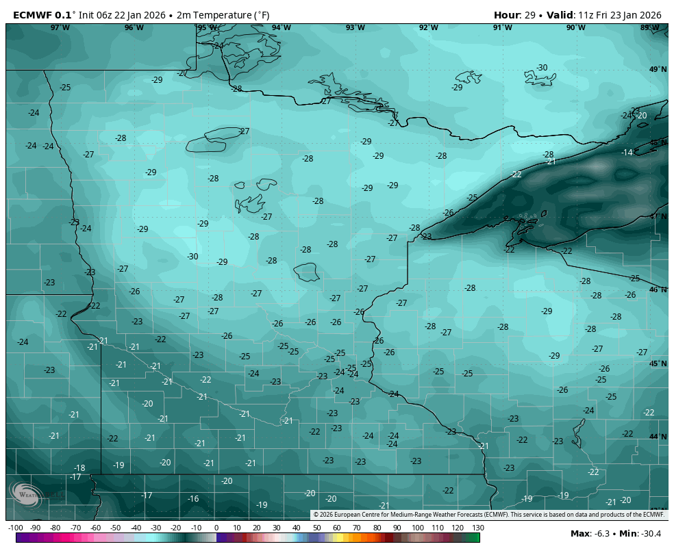
Good morning, neighbors! Nothing continues… Today, the Nothing will add mid-level clouds and be even darker! Starting tomorrow, the east side cold pool just barely taps into the arctic outbreak that’s menacing much of the nation. (See Minnesota map for Friday temps) Colder, less-humid air infiltrates the Gorge and (finally) forces the Nothing to back off some. Other than these minor details, which will feel major if the sun comes out in the central and eastern Gorge, not much changes through at least the middle of next week.
Glenwood this morning
Looking around this morning, we see sub-freezing temps pretty much everywhere with Nothing east of Home Valley. Parkdale wins this morning with 21 degrees, Grass Valley isn’t far behind at 23 degrees, and Glenwood is slacking at 26 degrees. Minneapolis is 6 degrees this morning, and by tomorrow afternoon, it’ll be MINUS 25 degrees. Send love to all the patriots there standing up to constitutional violations. Around here, we’ll have a frosty-road morning in the Nothing zone and potentially above it, but there are no signs of ¡CE-y roads this morning. Next ¡CE verifier training is this weekend in Portland, in person, through PIRC. Next online training is February 11th.
Next chance of rain? Who the F knows!?!?!
Thursday’s Gorge weather forecast
Thursday’s weather will be Nothing plus mid-level clouds, which will make it even darker. It’s a good day to cuddle up with a book (you) and write a dharma talk on the 8 Worldly Winds (me). Speaking of wind, easterlies continue: 40mph near Iwash (RELEASE THE pedo-FILES!) Rock this morning and 25mph this afternoon with 20-25mph near Stevenson all day and light easterlies elsewhere. In the Nothing, light freezing fog and riming of surfaces continues… You’ll find great beauty if you head out for a hike or drive in the Nothing zone!
Friday’s Gorge weather forecast
Models suggest the east side will tap into colder, drier Canadian continental air on Friday. This leads to reduced humidity and (please let it be so) clearing sky in the afternoon with temps rising to the upper 30s. That’s after a mid 20-something start for most places. Thanks to the colder, denser air on the east side, easterlies pick up. Again. Iwash: 40-50mph. Stevenson: 30-40mph with 25mph at the end of the day.
Saturday’s Gorge weather forecast
Nothing’s extent lessens on Saturday – it should start the day hovering near the Big River with clear sky away from the Nch’i Wana. Dewpoints Saturday morning drop into the single digits away from the river and hover in the 19-25F range near it. This leads to sub-20F temps in the clear sky zone and mid 20s under the Nothing. By afternoon, the temp-dewpoint spread widens. Clouds can’t handle this, and so the sky shall clear. THANK YOU BABY BIGHORN SHEEP FOR YOUR KINDNESS IN CLEARING THE SKY! Afternoon temps rise to the mid-upper 30s. East wind: 40-50mph at Iwash all day with 30-35mph at Stevenson.
Extended Gorge weather forecast
Boring, dry, rather chilly weather continues at least through the middle of next week, when it’s somewhat possible that we’ll see some precipitation. Maybe. Precipitation amounts keep dropping. And dropping. This is one heck of a dry winter we’re having. Mt Hood’s snowpack is currently at 33% of the median (1991-2020). While this isn’t the lowest snowpack year ever, it’s not far from it. If you have any pull with Ma Nature, please ask her to bring us snow. Safe travels. -TATAS
HEY! DON’T STOP READING! Is this community-focused forecast helpful to you? It sure is! It takes me a couple hours a day to write. Please join your friends and neighbors in contributing to keep it going. Venmo: @thegorgeismygym PayPal: twomirrors@gmail.com USPS: Temira / PO Box 841 / Hood River, Oregon 97031 You can test out the forecast subscription for a few days for free by signing up below. Easy! Do it!
JONES BEACH, SAUVIE ISLAND, & COAST FORECAST
ON WINTER VACATION UNLESS DESPERATELY NEEDED.
