

GORGE WIND FORECAST
If you’re still seeing yesterday’s and it’s after 9am, try opening this in an incognito window
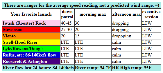
today’s gorge wind forecast
Hi friends! It was so fun to play with you on the river yesterday! It’s Saturday, and today’s Gorge wind forecast is for another round of westerlies. This one likely requires a bit of driving for the most consistent wind. Westerlies continue on Sunday, and then we enter a two-day recovery period before another round of westerlies on Wednesday.
Let’s dive in to today’s forecast. 6am pressures were 30.09/29.95/29.88 with lingering clouds from yesterday’s front and support from an offshore high based near California. An incoming system well offshore stirs things up this afternoon and decreases quality. Intermittent drizzle is likely EAST of The Dalles into early afternoon. Today’s probable focus for strongest wind: Mosier to Rufus.
All that said… we started the day with westerlies in the teens to low 20s under the clouds and mid 20s near Rufus with teens farther east. For the morning, we’ll have clouds on the west side with 17-20 from Stevenson to Viento, gusty 14-17 from Swell to Mosier (a short period of 17-21 is possible), and 22-25 from Lyle to Rufus. For the afternoon, the Stevenson to Hood River zone will be gusty 16-20ish. From Mosier (or maybe Lyle) to Rufus, westerlies rise to 27-31. Arlington may also join at that pace, but it may also be in the 23-26 range along with Threemile. Remember that those eastern Gorge sensors read high compared to Swell – 23-26 out there is like 19-22 at Swell. River flow over the last 24 hours was 210-253kcfs, river temp is 54.5F, and high temp forecast is 61F at both Hood River and Arlington.
RIVER FLOW FOR SITES BETWEEN AVERY (EAST OF THE DALLES) AND RUFUS: CLICK HERE FOR JOHN DAY DAM FLOW.
RIVER FLOW FOR SITES BETWEEN STEVENSON AND DOUG’S BEACH (WEST OF THE DALLES): CLICK HERE FOR THE DALLES DAM FLOW

tomorrow’s gorge wind forecast
Friday starts with light west wind, under 10mph most likely. Midday sees Avery-Arlington rise to 15-18mph before dropping to 11-14mph. West of The Dalles, the wind stays under 10mph all day. High temp: 57F under mostly cloudy sky.
extended Gorge wind forecast
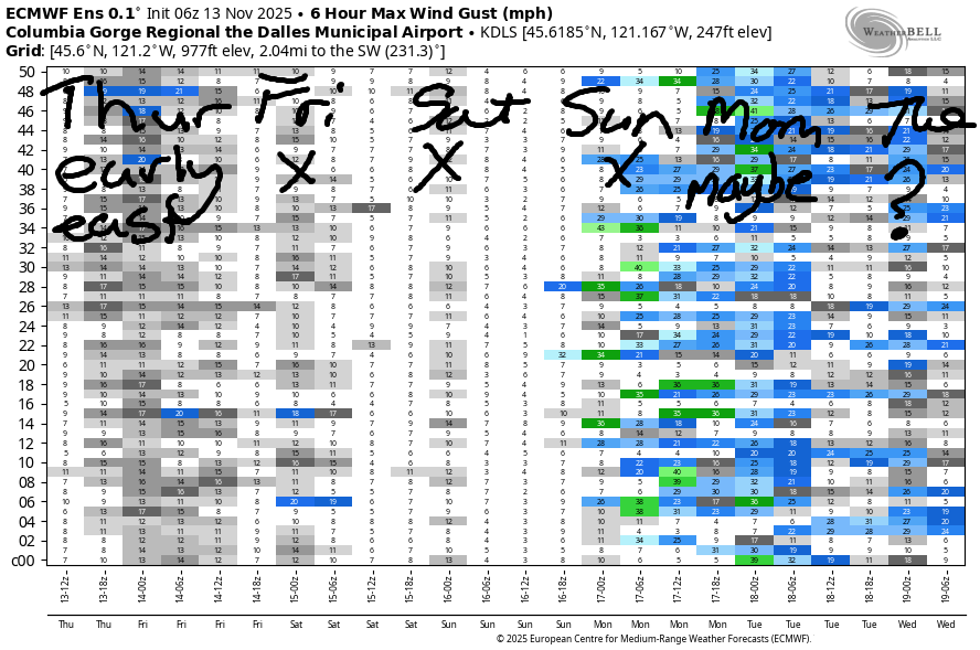
Saturday starts with light onshore, west, flow. The wind goes dead calm in the afternoon. High temp: 58F under clearing sky. Models give us a light easterly start on Sunday followed by a light westerly finish. A cold front swings through on Monday and offshore high pressure builds behind it. If the timing, setup, etc., works out just right, we could see a solid day at the Hatch. Fingers crossed! Hope to see you out there!
Was that helpful? I knew it was! Guess what? All of this crucial work – from your personal wind and snow reports to the invaluable TATAS updates – is made possible by my relentless efforts. Maintaining this labor of love isn’t easy. Each daily forecast takes hours. Website hosting, weather model access, and back-end admin work takes time and money. That’s where you come in.
YOUR CONTRIBUTION MAKES A DIFFERENCE
- SUPPORT ACCURATE, HYPER-LOCAL WEATHER FORECASTING
- ENABLE ACCESS FOR ALL, EVEN THOSE WITH LESS MEANS
- SUPPORT A COOL HUMAN WHO WORKS HARD SO YOU CAN PLAY
Take a moment to click one of the buttons below. Donate $19.99 or more (how much does this forecast enhance your life?) and get the email in your inbox. Whether it’s a renewing subscription (auto-renew) or a one-time donation, every contribution makes a real difference. Help me keep this labor of love alive, so we can all continue playing, commuting, and living in the Gorge with peace of mind and the best weather forecasts possible. Thank you!


Hood River, Oregon 97031


MT HOOD SNOW FORECAST

Hey skiers and snowboarders! Not much happens this weekend other than some rain on Mt. Hood, but models insist that temps will cool off enough for snow at the start of next week. Ensembles call for the snow level to bounce around between “low enough” and “marginal” for all of next week. Beyond next Thursday, there’s some indication of rising temps, but model spread increases and uncertainty is high, so maybe we’ll get lucky.
For Thursday, we have rain. The snow level will be 10,000′ all day. It falls to 6500′ overnight. About 0.3” rain falls today and another 0.1” overnight. Wind: SW 25-40 during the day and WSW 25-30 overnight. Friday starts with a little drizzle then turns partly cloudy. The snow level will be 6500′ during the day and 10,000′ overnight. Wind: WSW 25-30 in the morning, SW 20-35 in the afternoon, and W 30 overnight. Saturday will be cloudy. The freezing level will be 10,000′. Wind starts at W 30mph, turns light SW in the afternoon, and switches to S 10-15 overnight.
Sunday: partly cloudy then rainy with the snow level eventually falling to 5500′. Cooler temps and a few inches of snow are forecast on Monday. Midweek: dry for a day or two. That’s followed by more moisture later next week. Lots of uncertainty there about both quantity and temp, so I’ll hold off on any precision forecasting and just cross my fingers. You should do the same. Hope to see you on the snow soon!
BARE BONES HOOD RIVER WEATHER FORECAST
Clouds and rain this morning with clouds and intermittent, decreasing drizzle this afternoon. Temps start in the upper 40s and rise to the mid 50s. Light easterlies. 67% chance of rainbows. SIX SEVEN!!! Friday will be cloudy. Temps start in the mid 40s and rise to the upper 50s. Light westerlies. 11% chance of rainbows. Saturday will be mostly cloudy then partly cloudy. Temps start in the mid 40s and rise to the upper 50s. Light westerlies in the morning. Calm later. No rainbows.
TEMIRA’S AWESOME TRAVEL ADVISORY SERVICE
HYPERLOCAL WEATHER FORECAST FOR THE COLUMBIA GORGE
THE DALLES, HOOD RIVER, WHITE SALMON, TROUT LAKE, STEVENSON, CASCADE LOCKS, PARKDALE, ODELL, HUSUM, BZ, MILL A, WILLARD, GOLDENDALE, RUFUS, ARLINGTON, boardman

Good morning, neighbors! It’s Thursday morning here in the Gorge, and so far the roads (but not the hotels in The Dalles) are clear of ice and reasonably safe to drive. We’re expecting a fair bit of rain all the way east to Boardman today, so take that into account for your driving. Not much happens the next couple of days weather-wise, so I’m going to take a day off here or there to reclaim two hours in the morning and hopefully two hours of sleep!
Today’s Gorge weather forecast & Glenwood this morning
Looking at Thursday, we have a cloudy, aurora-blocking start. Drizzle is falling. Drizzle transforms to rain. We’ll have moderate rain to The Dalles by sunrise and east to Boardman shortly after. Rain tapers off this afternoon leaving us under mostly cloudy sky all across the land. Snow level: 10,000′ despite some weird sleet-like stuff in High Prairie this morning. In Glenwood this morning, it was 43 degrees. If you add 4+3 you get 7. All you have to do now is look around to find a 6. SIX SEVEN!!! Temps today max out in the mid 50s. Wind will be annoying near Iwash (RELEASE THE FILES!) Rock early: 45mph, but it will drop to 20-25mph midday and turn light westerly this evening. Stevenson: 25-30mph early but relief is in sight: the wind shuts off this afternoon.
Friday’s Gorge weather forecast
Overnight, we have a bit of drizzle as far east as Cascade Locks with clouds west of The Dalles and partly cloudy sky to the east. Temps on Friday start in the 40s and warm to 57F (west) and 61F (The Dalles), which unfortunately won’t be warm enough to transform hearts of ICE to hearts of compassion. Other Friday news includes light west wind west of The Dalles with 15mph westerlies to the east. Sounds like a lovely day: sunshine and upper 50s. Yay! You’ll find me on my bicycle soaking up the rays and practicing the magic of converting solar energy to Vitamin D.
Extended Gorge weather forecast
Saturday will be mostly cloudy to start and mostly sunny in the afternoon. A mid-40s start allows temps to rise to 60F or so. A little rain is possible early near Biggs, but that won’t last long. Wind: light and variable. Sunday: dry in the morning, rainy later, 55 degrees, and light/variable wind. On Monday, a cold front arrives and sets us up for wetter, colder, winder weather with snow levels falling down to pass level. We’ll talk details when we get closer. I need to go poop now. Safe travels. -TATAS
HEY! DON’T STOP READING! Is this community-focused forecast helpful to you? It sure is! It takes me a couple hours a day to write. Please join your friends and neighbors in contributing to keep it going. Venmo: @thegorgeismygym PayPal: twomirrors@gmail.com USPS: Temira / PO Box 841 / Hood River, Oregon 97031 You can test out the forecast subscription for a few days for free by signing up below. Easy! Do it!
JONES BEACH, SAUVIE ISLAND, & COAST FORECAST
ON WINTER VACATION UNLESS DESPERATELY NEEDED.
