

MT HOOD WEATHER FORECAST
Hey skiers and snowboarders! If you want it when it’s not raining, get it today (Thursday) and tomorrow. This weekend is looking mighty wet with up to 5” of rain in the forecast between Saturday night and Monday morning. Thanks a lot, Pineapple Express! If that’s you’re only opportunity to ride, aim for Saturday morning – the drizzle should be light enough Saturday daytime that it won’t ruin your day. In case you’re curious, this event will be driven by a moderate to strong atmospheric river. This is an impressive one! Looking past the Pineapples to Monday night, we might pick up a little snow. After that, warm, sunny weather is in the cards for a while.
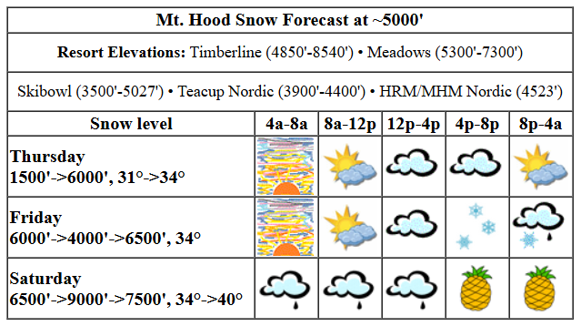
But let’s start with today’s weather on Mt. Hood. Other than a few high clouds, the day starts sunny. Snow conditions are reportedly a mix of packed pow, hardpack, and granular depending on where you go. Clouds take over this afternoon and stick around overnight, but no precip is forecast. The free air freezing level will be around 1500′ this morning, 3500′ this afternoon, and 6000′ overnight. Temps at 5000′ start in the low 30s (it’s in the low 20s lower down) and rise to the mid 30s tonight. Wind will be WNW 25-35 early, NNW 10-15 this afternoon, and light/variable overnight.
Moving on to Friday… the day starts mostly clear and quickly turns cloudy. Drizzle or mixed precip starts up around 1pm and continues overnight. The snow level will be around 6000′ in the morning, 4000′ in the afternoon, and 6500′ after midnight. Temps at 5000′ will be in the mid 30s all day. A trace of precip is forecast prior to 4pm. That’s followed by 0.3” water equivalent (WE) of mixed precip overnight. It may start as snow or snain, but it’ll switch to rain after midnight. Friday’s wind: light/variable in the morning, SW 15-30 in the afternoon, and WSW 20-25 overnight.
Light drizzle Saturday daytime gives way to steady rain overnight. Is that your favorite Mt. Hood weather? No? Mine neither! The snow level will be 6500′ in the morning, 9000′ in the evening, and 7500′ after midnight. Temps start in the mid 30s and rise to 40F or so. A trace of rain is forecast during the day, which means the riding shouldn’t be all that bad. Overnight, 1.1” rain is forecast. That will be bad, but not the worst I’ve seen (6” or more in a 24 hour period). Wind on Saturday: WSW 20-25 in the morning, SW 20-40 in the afternoon, SW 30-55 in the evening, and W 30 after midnight.
On Sunday, the atmospheric river and the jet stream take aim at Mt. Hood for some truly impressive wet weather. With just a bit of south in the wind, rain totals won’t be as high as they would be with a W or NW wind, but it’ll still be very wet. The snow level will be 7500′ in the morning, 9000′ in the afternoon, and 6500′ overnight. Temps hover around 40F at 5000′ all day and into the evening before dropping to 33-34F overnight. About 1.6” rain is forecast during the day. That’s followed by 1.3” rain overnight. Don’t be surprised if we beat those totals given the combo of lots of available moisture and lots of wind: W 30mph in the morning, WSW 50-60mph in the afternoon, WSW 70-85mph in the evening, and W 35mph after midnight. It’s likely lifts will go down in the evening, but you probably figured that out yourself!
Sunshine Monday morning gives way to cloudy in the afternoon and rain in the evening. That should switch to snow overnight and leave us with maybe 1-3” new. A little more snow is possible Tuesday daytime. We then transition to warm, sunny weather for several days. Temps will push well past 40F at 5000′ and maybe even hit 50F. Dig out the yellow wax. You’ll want it. See you on the snow!
Liking this forecast?
Was that helpful? I knew it was! Guess what? All of this crucial work – from your personal wind and snow reports to the invaluable TATAS updates – is made possible by my relentless efforts. Maintaining this labor of love isn’t easy. Each daily forecast takes hours. Website hosting, weather model access, and back-end admin work takes time and money. That’s where you come in.
YOUR CONTRIBUTION MAKES A DIFFERENCE
- SUPPORT ACCURATE, HYPER-LOCAL WEATHER FORECASTING
- ENABLE ACCESS FOR ALL, EVEN THOSE WITH LESS MEANS
- SUPPORT A COOL HUMAN WHO WORKS HARD SO YOU CAN PLAY
Take a moment to click one of the buttons below. Donate $19.99 or more (how much does this forecast enhance your life?) and get the email in your inbox. Whether it’s a renewing subscription (auto-renew) or a one-time donation, every contribution makes a real difference. Help me keep this labor of love alive, so we can all continue playing, commuting, and living in the Gorge with peace of mind and the best weather forecasts possible. Thank you!


Hood River, Oregon 97031


GORGE WIND FORECAST

Hi friends! Once again the westerlies waited until after dark to make a showing, and they were pretty minimal. Speaking of minimal, that’s the forecast for the next five days. But hey, there will be plenty of rain! Thursday starts with westerlies in the 10-13ish range all the way from Stevenson to Arlington. That’s about all we’ll see today, and the wind will drop to 7-10mph this afternoon. River flow over the last 24 hours was 71-136kcfs, river temp is 37.94F, and high temp forecast is 48F.
Friday brings easterlies. Iwash starts with 35mph, and Stevenson starts with 20-25mph. By late morning, the wind falls to 10-15mph at Iwash and 15-20mph at Stevenson. We’ll end the day with 10mph at Stevenson and 15mph at Iwash. High temp: 46F and cloudy with rain in the afternoon. Saturday doesn’t bring much – easterlies will be 10-15mph at both Stevenson and Iwash in the morning and afternoon with calm wind all day. High temp: 52F with drizzle early, dry weather midday, and pouring rain in the evening. Sunday: calm with westerlies arriving after dark. Monday: westerlies switching to easterlies. Next chance for reliable, usable wind might be later next week when stronger, warmer easterlies are possible. Fingers crossed for that!
BARE BONES HOOD RIVER WEATHER FORECAST
Clouds this morning and partly cloudy this afternoon. Temps start in the id 40s and rise to the upper 40s. Light westerlies. No rainbows. Friday will be Nothing to start and cloudy to finish with rain starting mid afternoon. Temps start near freezing and rise to the mid 40s. Easterlies. No rainbows. Saturday will be drizzly in the morning, briefly dry in the afternoon, and soaking wet overnight. Sky: mostly cloudy then cloudy. Temps start in the upper 30s and rise to the low 50s. Calm wind. 8% chance of rainbows.
TEMIRA’S AWESOME TRAVEL ADVISORY FORECAST
HYPERLOCAL FORECAST FOR THE COLUMBIA GORGE
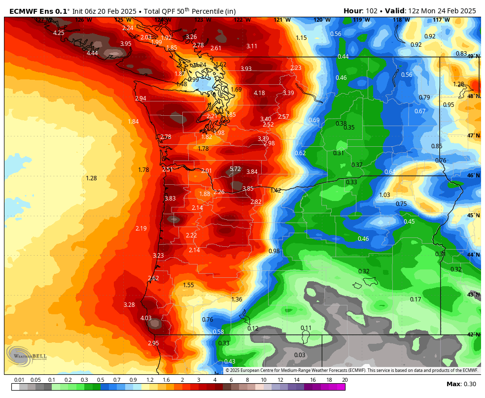
Good morning, neighbors! Stoke yourself up for a couple of dry days, and then steel yourself for a very wet weekend. Or make plans to head east of the Cascades, where rain shadowing will keep things dry much of the time. Unless you enjoy driving down a freeway that resembles a river, skip 84 west of Hood River from Saturday afternoon on through Monday morning. After that, we’ll see lesser rain into Tuesday followed by warm, dry weather for the rest of the week. Do you hear that sound? It’s your garden calling you!
Before we get to the forecast, let’s check in with Glenwood, center of the universe. It’s 30 degrees with a dewpoint of 25. That’s quite a bit colder than the rest of us, so it must be clear there and not touched by the westerlies. TATAS Executive Order Of The Day: some sort of quarter/trimester-long constructive communication program shall be required for all students in grade 6. Signed with my red fine-point Sharpie.
TODAY
On to today’s weather… no, wait… it was warm enough this morning that when I went outside in shorts to wax my skis, I didn’t freeze. We’ll start the day with clouds to the west and sun out east. Watch for icy roads out near Dufur, High Prairie, Glenwood, Snowden, and other associated areas where the universe stole the degrees overnight. Clouds increase today, but precip stays away. Temps max out in the upper 40s. Along the Nch’i Wana (Big River), westerlies start at 10-15mph and fade to 7-10mph.
FRIDAY
Offshore flow returns overnight, temps drop, and clear sky sends most of us below 32F. Along the Big River, Nothing forms. Rain starts up early afternoon west of Viento, arrives in Celilo Village late afternoon, and pushes all the way to Boardman in the evening. Heaviest rain, naturally, will be during the evening commute: 4-7pm west of Hood River. You can expect steady moderate rain from 7pm to 10mph all the way east to Arlington and into SW/Sherm. Rain intensity backs off overnight. Wind on Friday will be E 35mph at Iwash in the morning and E 15mph there in the afternoon. Stevenson: 25mph fading to 10mph. Elsewhere: not so much wind. Friday’s high temp: mid 40s.
Now we get into the fun stuff!
SATURDAY
Drizzle west of The Dalles Saturday morning gives way to dry weather in the afternoon. Don’t be lulled into complacency (that applies in the world too – you are being tested right now). Pineapple Express pulls into the Gorge in the evening. Torrential rain is forecast west of Hood River with moderate rain to Rowena and heavy rain in the WA hills east to Goldendale Heavy rain eventually extends to Amayah’s and beyond with rain most of the way east to Idaho. Now, you might be wondering what I mean by “torrential”. I mean 0.3”/hr. In other words, if you’re going to the metro area for an event on Saturday evening, you’re going to have quite the drive there and back. Saturday’s high temp: 52F. Wow! Wind: light easterly.
SUNDAY
Heavy rain continues west of, oh, Rowena or so all the way into Monday morning. Areas east of The Dalles will be rainy too for most of the day Sunday, say, through 4pm. SW/Sherm: also rainy, at least in the morning. For the drive through the gauntlet, the wettest zone west of Viento, things will be river-like all day and waterfall-like in the evening, once again messing up your evening plans in the big city. Temps max out at 50+ in the lowlands.
MONDAY AND BEYOND
Rain tapers off Sunday night and leaves us with a mostly dry Monday. Tuesday looks wet, but not as wet as the weekend. After that: dry, sunny, warm weather for at least a few days. Get this: Modes give us a shot at 50+ degrees every day starting Sunday, and they like the idea of 60+ Wednesday through Friday. I had to go and look at the average and record high temps for that time period because I was curious. Average high temp for next week is 50F. Records run from 63-68F. If we get lucky, we could see a record high temp somewhere in there. This, naturally, made me wonder when 70F is possible. In 2005, we had a stretch of 70+ degree weather from 3/7 to 3/12. Beyond 3/15, all of the records are above 70F. It appears spring is starting… that brings us to…
Valuable Advice for Gardeners Inhabiting Neighboring Areas: if you haven’t yet started your artichoke seeds, get on it. You can also go ahead and start onion seeds. Those not-recyclable clam-shell plastic containers make great containers for starting onion seeds. I know you want to start your pepper and tomato seeds, because I want to start mine. Hold off. Start those peppers about 8 weeks prior to last frost, and start tomatoes 6-7 weeks prior to last frost. Happy gardening. Safe travels. -TATAS
HEY! DON’T STOP READING! Is this community-focused forecast helpful to you? It sure is! It takes me a couple hours a day to write. Please join your friends and neighbors in contributing to keep it going. Venmo: @thegorgeismygym PayPal: twomirrors@gmail.com USPS: Temira / PO Box 841 / Hood River, Oregon 97031 You can test out the forecast subscription for a few days for free by clicking this link: https://subscribepage.io/YhevGc
