

MT HOOD WEATHER FORECAST
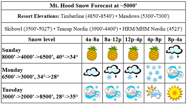
Hey skiers and snowboarders! The Pineapple Express took over the Mt. Hood weather this morning, and chaotic weather is likely for the next couple of days. That’s followed by warm, sunny conditions to finish off next week. Looking at next weekend, we have significant differences in the main models on precip amounts, so I’m going to hold off on making any predictions for now. Snow conditions today: wet pack with areas of wet granular and areas of partially-transformed snow. Wax: yellow.
Mt. Hood picked up two inches of rain already, and rain continues into Sunday evening. The snow level will be 8000′ this morning, 7500′ this afternoon, briefly as low as 4000′ this evening, and back to 6500′ after midnight. Temps at 5000′ start near 40F, fall as low as 33F this afternoon, and rise to 34-35F overnight. About 1.8” rain is forecast today. That’s followed by 0.5” mixed precip this afternoon for perhaps an inch or two of wet snow above 5000′. Overnight, the sky clears. High clouds return after midnight. Wind today will be WSW 30-40 this morning, W 55-60 this afternoon, WSW 40 this evening, and SW 10-20 overnight. That period of strongest wind, 1-4pm or so, could knock some lifts offline.
Monday starts off dry, but mixed precip returns by sunrise. The snow level will be 6500′ early, 4500′ in the afternoon, and 3000′ after midnight. Temps will be in the 33-35F range early, 32F in the afternoon, and upper 20s overnight. During the day, 0.4” water equivalent (WE) mixed precip is forecast for 1-3” wet new snow. Overnight, 1.4” WE is forecast as snow for 12-16” new. Wind will be SW 10-20 early. It rises to SW 30-60 in the afternoon (depends on exposure), and potentially WSW 85 overnight. Yeah, you read that right! This really depends on the path of an incoming low pressure system; the deterministic GFS places it in exactly the right spot for extreme overnight wind that will knock down trees and turn all that fresh snow into windslab and sastrugi.
IF the low holds that path, Tuesday will start with full-on blizzard conditions: dumping snow and blasting wind, strong enough to shut down all the lifts. As of right now, we’re looking at 70mph west wind Tuesday morning with dumping snow, perhaps up to a foot of new. The wind is forecast to back off in the afternoon, but it’s questionable if it will back off enough to turn more than a few lifts. The snow level will be 3000′ in the morning, 2000′ in the afternoon, and as warm air returns in the evening, 8500′ overnight. Temps will be in the upper 20s at 5000′ early and will rise to the 33-38F range (depending on location) Tuesday night. All that said, I can’t really give you an accurate or precise forecast for Tuesday until we know where that low is headed – that extreme wind forecast could shift enough to get you on the lifts. We’ll look again tomorrow morning!
Wednesday, Thursday, and Friday are easy: warm and dry with relatively light wind. Temps will rise to the 40s or even 50F. For next weekend, we’ve got the GFS calling for moisture and the Euro staying mostly dry. So, I’ll leave it here for now. Grab your poncho or plastic bag and head to the slopes for fun in the rain today. See you on the snow!
Liking this forecast?
GORGE WIND FORECAST

Hi friends! Looks like we have a shot at wind for the next five days, but some of it’s probably going to come in too late in the day to be useful. Keep a close eye on Tuesday as the forecast shifts around – there’s some indication of a nuking day. Let’s start with Sunday: we have light onshore gradients and light/variable wind to start. The wind turns westerly this afternoon, first between Iwash and Viento and then spreading eastward. Models give us W 17-20ish all the way from Iwash to Arlington, but unfortunately they point at a 4pm or later start time. It’s going to be close. River flow over the last 24 hours was 110-133kcfs, river temp is 37.40F, and high temp forecast is 54F with lots of rain.
Monday starts with widespread easterlies as a low zips north in the Pacific. Max wind will be mid-morning at 30mph at Stevenson and 35mph at Iwash. In the evening, probably after dark, the wind turns westerly and builds overnight. High temp: 50F and pouring rain. A low moves inland Tuesday. Depending on its path, we could have anything from nuking wind to uninspiring wind. Either way, the wind will be westerly, and I’m definitely keeping a close eye on it. Models agree on easterlies, probably 30-35mph, for Wednesday. It’ll be windy everywhere, but probably best and driest at Rufus if this forecast pans out. Ensembles call for lighter wind for Thursday and Friday. Hopefully that forecast has something in it for you. Have a great day today!
BARE BONES HOOD RIVER WEATHER FORECAST
Rain this morning turns torrential this afternoon and shuts off overnight. Temps start in the mid 40s and rise to the mid 50s. Calm wind most of the day. Light to moderate westerlies late. 19% chance of rainbows. Monday will be rainy from sunrise on into the evening. Temps start near 40 and rise to 50 or so. Light easterlies. Westerlies late. Very strong overnight. 49% chance of rainbows. Tuesday will be soaking in the morning and dry in the afternoon. Temps start near 40 and rise to 50 or so. Nuking westerlies. 99% chance of rainbows
TEMIRA’S AWESOME TRAVEL ADVISORY SERVICE
HYPERLOCAL WEATHER FORECAST FOR THE COLUMBIA GORGE
THE DALLES, HOOD RIVER, WHITE SALMON, TROUT LAKE, STEVENSON, CASCADE LOCKS, PARKDALE, ODELL, HUSUM, BZ, MILL A, WILLARD, GOLDENDALE, RUFUS, ARLINGTON, boardman
Good morning, neighbors! It’s another wet one. Very wet. Becoming very, very wet later. If you can skip the drive to/from the metro area or through the western Gorge today, skip it. Repeat that heavy rain and drive skipping on Monday, and follow it up with some potential for damaging west wind Monday night into Tuesday. Then you can let out that breath you’ve been holding, at least the breath you’ve been holding due to the weather. Keep holding the one about our democracy. Dry, warm weather is forecast Wednesday through Friday. Before I forget… if you’re out and about driving, watch out for rocks in the road. All this moisture is likely to make them fall down.
GLENWOOD, TATAS EOOTD
Before we dive in… Glenwood, the center of the universe, is 42F this morning with a dewpoint of 34F. They’ve picked up 0.77” rain in the last 24 hours. TATAS EOOTD: In line with the progressive democracies of Europe, some speech shall be regulated. Now prohibited: calling for violent measures against minority groups (Germany), deliberately insulting folks based on race, religious, sexual orientation, or disability (Netherlands, Denmark), public statements aimed at inciting hatred (Netherlands, Germany), Holocaust denial and downplaying or approving of Nazi crimes (Germany, France). Why? Because of the Paradox of Intolerance – if hateful, cruel, violent intolerant speech is tolerated, it eventually comes to dominate the discourse. Taking a bigger-picture view of this, it’s a sad statement on human nature that unregulated speech doesn’t give way to kindness, compassion and generosity but rather gives way to hate and intolerance. How can each of us work to change that?
TODAY (SUNDAY)
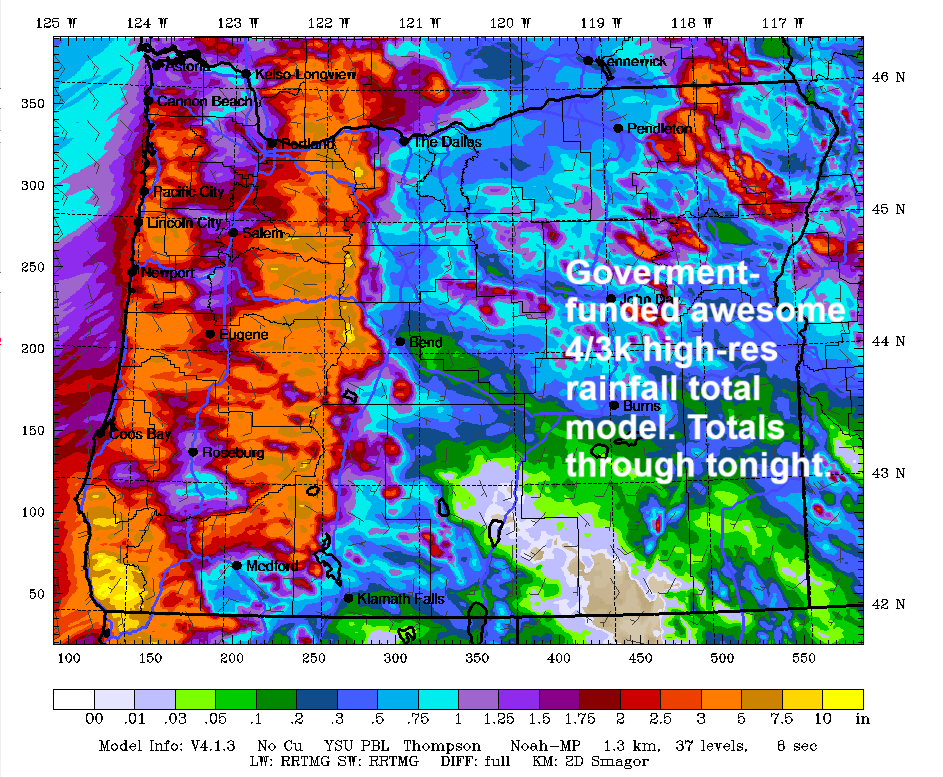
On to the weather! Today brings rain and plenty of it, almost certainly enough to erase the 1.32” deficit Hood River is showing for the rain year. You can check your predicted total by looking at the awesome 4/3k WRF-GFS precip image, a federally-funded resource. Don’t be fooled by the lessening of rain this morning. POURING, absolutely TORRENTIAL rain is forecast from late morning on into the evening west of Hood River and eventually all the way east as far as you can see until the horizon cuts off your view. This happens because the Earth is round, not flat. High temps rise to the low-mid 50s in the lowlands. West wind picks up late to 15-20mph all the way from Iwash to Arlington and beyond. Rain stops, mostly, after 10pm.
MONDAY
The break in the rain ends by 7am Monday. Pouring rain continues pretty much all day and all night west of Hood River. Intermittent heavy rain continues on and off east of The Dalles. Add in easterlies at 30-35mph in the morning for a sucky drive to the metro area. Watch out for that sneaky puddle near the brown Ainsworth sign on westbound I-84! The wind fades in the afternoon and turns westerly overnight. High temp: 50F or so with the snow level around 6000′ most of the day and falling to 3000′ overnight.
This is when things could get very interesting. Let’s take the broad-brush look at it:
TUESDAY
A low zips up the coast Monday night, and a trough moves inland. Depending on the exact route and strength of this, chaos may ensue. At least some models bring NUKING west wind to the Gorge in the wee hours of Tuesday morning along with pouring rain west of Hood River. Those enthusiastic ensemble members have enough wind to knock down trees in the Viento area and potentially other places. I’m keeping a close eye on this for sure. Temps max out in the low 50s Tuesday, and dry weather returns in the afternoon.
WEDNESDAY AND BEYOND
The whole damned PNW weather situation calms the F down on Wednesday. We’re left with warm, dry weather Wednesday, Thursday and Friday with sun for Wednesday and Friday and high clouds for Thursday. I see gardening in your future – it’s definitely in my future! There’s too much uncertainty to forecast for next weekend yet, so I’ll leave it here for now. Safe travels. -TATAS
HEY! DON’T STOP READING! Is this community-focused forecast helpful to you? It sure is! It takes me a couple hours a day to write. Please join your friends and neighbors in contributing to keep it going. Venmo: @thegorgeismygym PayPal: twomirrors@gmail.com USPS: Temira / PO Box 841 / Hood River, Oregon 97031 You can test out the forecast subscription for a few days for free by clicking this link: https://subscribepage.io/YhevGc
