

GORGE WIND FORECAST
today’s gorge wind forecast
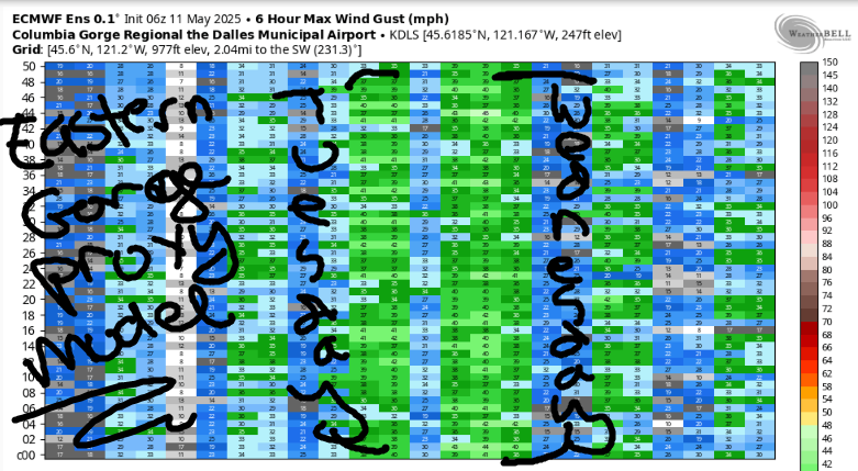
Hi friends! A more active weather pattern slides in for the next couple of days and keeps westerlies in the Gorge wind forecast. This weather “activity” is supplemented Tuesday through Thursday by a supportive offshore high that drives stronger westerlies. Generally speaking, there are hints of west wind of some sort in the forecast in the ensembles for the next ten days and potentially beyond. As of this morning, ensembles peg Wednesday as the strongest eastern Gorge day of the next week with Tuesday a close second. Those same ensembles struggle to capture the Hatch due to low resolution, but there are definitely hints of a solid Hatch day next Thursday. Let’s take a look at the short-term forecast, shall we?
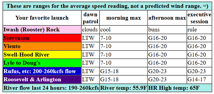
Sunday started with pressures of 29.88/29.84/29.80 for gradients of 0.04/0.04 and light west wind. As I was writing this, the iWind/iKite sensors were reading 13 at both Viento and Swell, and that’s about all we had at Dawn Patrol time. Today’s wind potential gets squashed by a low pressure system offshore. Even with it there, models give us just enough thermal support for afternoon westerlies. Morning wind stays just where’s it’s at: 10mph or less most places with periods of 11-14mph from Viento to Swell. Afternoon wind slowly builds to gusty 16-20 from Stevenson to Mosier with gusty 19-23 from Avery to Rufus. East of there: 10mph or less. It’s worth mentioning that we’ll be dealing with drizzle near Cascade Locks and between The Dalles and Rufus this morning. We’ll also have atmospheric instability in the picture this afternoon. The combo of the two will work to potentially suppress wind speeds below this forecast’s guesses. It’s just not a great setup today, but that doesn’t mean there won’t be enough for some of you to get on the river! River flow over the last 24 hours was 190-260kcfs (200-260kcfs at Rufus), river temp is 55.9F, and high temp forecast is 65F with mostly cloudy sky most of the day.

tomorrow’s gorge wind forecast
Monday sees that pesky low move inland along the ORCA border. The associated cool air triggers atmospheric instability, which tends to suppress wind on the river. Behind the low, high pressure builds offshore. For whatever reason, this almost always takes longer to impact the Gorge than models suggest. So, keeping all that in mind… the day starts with less than 10mph west of The Dalles and 13-16mph east of The Dalles. If the instability doesn’t disrupt the wind field too much, we’ll see afternoon speeds at 20-23mph from Lyle to Rufus with 17-20mph from Philippi Canyon to Boardman. Between Stevenson and The Dalles, westerlies slowly build: 11-14 midday, 15-18 mid-afternoon on. Instability increases after 2pm and could have a significant impact on the wind. High temp: 62F with clouds in the morning and partly cloudy sky in the afternoon.
extended Gorge wind forecast
Atmospheric shenanigans decrease on Tuesday as offshore high pressure dominates the picture. A weak system swings through during the day and disrupts the wind field a bit. Even so… the day starts with 7-10 west of The Dalles with 19-22 from Avery to Boardman. Between Stevenson and Lyle, clouds limit the wind. Call it 14-17 for that zone. Between Lyle and Arlington, westerlies slowly build to 26-29 with the potential for 28-32 from Rufus to Arlington. High temp: 63F with mostly cloudy sky most of the day. Ma Nature stabilize the setup some on Wednesday for 30-33 in the afternoon east of The Dalles with 16-19ish west of The Dalles. I’ve got my eyes on Blalock-Arlington for Wednesday. Fingers crossed! Keep your eyes on Thursday in the Corridor for 25mph or so at the Hatch. Model clarity decreases after that, but generally keeps west wind in the picture for the long haul. Have a great day today. See you on the Nch’i Wana!
Was that helpful? I knew it was! Guess what? All of this crucial work – from your personal wind and snow reports to the invaluable TATAS updates – is made possible by my relentless efforts. Maintaining this labor of love isn’t easy. Each daily forecast takes hours. Website hosting, weather model access, and back-end admin work takes time and money. That’s where you come in.
YOUR CONTRIBUTION MAKES A DIFFERENCE
- SUPPORT ACCURATE, HYPER-LOCAL WEATHER FORECASTING
- ENABLE ACCESS FOR ALL, EVEN THOSE WITH LESS MEANS
- SUPPORT A COOL HUMAN WHO WORKS HARD SO YOU CAN PLAY
Take a moment to click one of the buttons below. Donate $19.99 or more (how much does this forecast enhance your life?) and get the email in your inbox. Whether it’s a renewing subscription (auto-renew) or a one-time donation, every contribution makes a real difference. Help me keep this labor of love alive, so we can all continue playing, commuting, and living in the Gorge with peace of mind and the best weather forecasts possible. Thank you!


Hood River, Oregon 97031


JONES BEACH, SAUVIE ISLAND, & COAST FORECAST
Wind northerly unless otherwise indicated. For coast, it’s North/Central/South with the “central” at approximately Florence. Swell forecast from NWS for central coast. Jones: westerly unless otherwise stated. Sauvie Island: northerly unless otherwise stated. Coast Sunday: SW25/S20-25/S30-35, W swell 5′ at 9 seconds. Monday: NW10-15/LTNW/LTS, W 7′ @ 10. Tuesday: NW10-15/LTNW/LTN, NW 9′ @ 10. Jones Sunday: LTW. Monday: 13-16. Tuesday: LTW. Sauvie Island Sunday: SW 15-20. Monday: variable to 10. Tuesday LTS.
BARE BONES HOOD RIVER WEATHER FORECAST
Clouds most of today with partly cloudy sky in the evening. Very slight chance of thunderstorms. Temps start in the mid 50s and rise to the mid 60s. Light westerlies in the morning. Moderate later. 2% chance of rainbows. Monday will be cloudy then partly cloudy with a slight chance of thunder. Temps start in the mid 40s and rise to the low 60s. Light westerlies early. Moderate later. 5% chance of rainbows. Tuesday will be cloudy most of the day then partly cloudy. Temps start in the mid 40s and rise to the low 60s. Light westerlies in the morning. Moderate later. No rainbows.
TEMIRA’S AWESOME TRAVEL ADVISORY SERVICE
HYPERLOCAL WEATHER FORECAST FOR THE COLUMBIA GORGE
THE DALLES, HOOD RIVER, WHITE SALMON, TROUT LAKE, STEVENSON, CASCADE LOCKS, PARKDALE, ODELL, HUSUM, BZ, MILL A, WILLARD, GOLDENDALE, RUFUS, ARLINGTON, boardman

Good morning, neighbors! If you like clouds, you’re in the right place! Sure, we’ll have plenty of sunbreaks over the next week, but generally speaking, the weather for the next 7-10 days will be cooler than normal and cloudier than recently. Some of us will pick up a little drizzle here and there, but there’s no sign of a real soaking for anyone east of Cascade Locks any time soon.
glenwood
To start the day Sunday, Glenwood was 48 degrees, a veritable heat wave, a tropical interlude. Everyone else: above freezing. Me: sleeeeeeepy. I went to bed at 11pm, which is very, very, very late!
today’s gorge weather forecast
Sunday’s opening gambit: a bit of drizzle west of Wyeth. Areas between The Dalles and Amayah’s (the location formerly known as Biggs) along with south Wasco County were a bit wet this morning too, as was I thanks to a hot flash. Drizzle continues in those locations until midday, after which we all dry out like the bread I made last night and will turn into croutons today. Partly to mostly cloudy sky is in the cards until early evening, when clearing appears for a brief time. Morning wind will be light. Afternoon wind rises to 15-20mph west of Lyle and 20-25mph from Lyle to Rufus. East of there: lighter wind. Max temps today will be in the low 60s.
Monday’s gorge weather forecast
Monday looks mostly cloudy most of the day with partly cloudy sky in the afternoon. There’s a very slight, wee chance of thunderstorms. Monday is Vesak, Buddha Day, a celebration of the Buddha’s birth, enlightenment, and death. We Buddhists take the day to reflect on the Buddha and also to practice compassion, kindness, and generosity (and all the other paramis and brahmaviharas). You don’t have to be a Buddhist to join in on those practices and intentions; they benefit you and the world no matter what religion inspires you. After a mid-40s start, temps only rise to the low 60s, which I think is the ideal temperature for doing pretty much anything active outside. West wind will be less than 10mph west of The Dalles early with 10-15mph east of The Dalles. Afternoon wind builds to 15-20mph west of Mosier with 20-25mph from Lyle to Rufus and 15mph east of Rufus. Once again, we’ll have morning drizzle west of Wyeth and east of The Dalles.
extended gorge weather forecast
Temps on Tuesday mimic Monday’s, as do the clouds: cloudiest early, partly cloudy later. Wind will be 10mph west of The Dalles early with 20mph east of The Dalles early. Afternoon westerlies rise to 15-20mph west of Lyle and 25-30mph between Lyle and the Arlington Triangle. On Tuesday, you should put Underworld’s “Spoonman” on repeat and dance your ass off. A similar-to-Tuesday, but winder (east of Mosier, anyway) day is forecast for Wednesday. We’ll continues with cool, partly cloudy weather into the end of the week. About half the ensemble members bring a round of widespread, but not all that soaking, rain for Saturday. It’ll be wet, of course. Rain always is, but it won’t drench you like a monsoonal downpour. This time of year, rainfall in the models often decreases the closer we get, so don’t get too excited.
valuable advice for gardeners inhabiting neighboring areas
Valuable Advice for Gardeners Inhabiting Neighboring Areas: I went to bed way too late last night and am struggling to come up with sage gardening advice. Obviously the cooler, cloudier weather is great for getting seeds going. Even with the clouds, the sun is so strong this time of year that it’ll keep soil temps near ideal germination for a whole host of plants. And thanks to the cloud cover, frost chances are going to be minimal for the next week to ten days. And you won’t have to water constantly to support seedling germination. Happy gardening. Safe travels. -TATAS
HEY! DON’T STOP READING! Is this community-focused forecast helpful to you? It sure is! It takes me a couple hours a day to write. Please join your friends and neighbors in contributing to keep it going. Venmo: @thegorgeismygym PayPal: twomirrors@gmail.com USPS: Temira / PO Box 841 / Hood River, Oregon 97031 You can test out the forecast subscription for a few days for free by signing up below. Easy! Do it!

One response to “Sunday’s Gorge wind forecast: marginal today, but cooler with lots of wind in the next 7-10 days.”
Awesome job TATAS! Drawing s extra 🙂