

MT HOOD WEATHER FORECAST
Hey skiers and snowboarders! Mother Nature’s playing some games with the Mt Hood weather this morning. The weather contains a mix of precip types: snain, sleet, snow… that’s just rotating through like the Wheel of Fortune spinning. Temps are forecast to drop a couple of degrees by mid-morning, and the p-type should switch over to snow. Snowfall intensity ramps up this afternoon and continues to dump fresh snow all the way through Monday afternoon. Up to a couple feet of fresh is anticipated, or maybe I should say, a couple inches of water equivalent. Given the temps, snow density is likely to be under 1:10 ratio. We’ll have a brief break in the weather Tuesday before heavy snow returns Tuesday night into Thursday. After that, the weather warms. Models generally agree on (probably) dry weather next Saturday, but about 70% of them have a significant Pineapple Express event on Sunday. More on that later. Snow type today: a mix of wet pack, dense packed snow, and maybe packed powder later if it cools off enough.
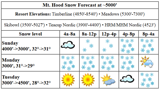
Sunday kicks off, as I said, with the menagerie of p-types. Snow should be predominant from late morning on. The snow level will be around 4000′ this morning. It falls to 3500′ this afternoon and 3000′ overnight. Temps fall from 32F at 5000′ to 30-31F. About 0.3” water equivalent (WE) is forecast today for 2-3” dense new snow. Overnight, 08” WE is in the cards for 6-7” dense new snow. Wind will be WSW 25-35 this morning, SW 15-30 this afternoon, and W 25-30 after midnight. That west wind should amp up the snowfall intensity and perhaps help us exceed 6-7”.
Heavy snow is forecast all day Monday. It tapers off overnight. The snow level will be 3000′, maybe 3500′, all day long, and it’ll fall to 2500′ after midnight. Temps will be in the 30-31F range to start and will fall to the 29-31F range. About 1.0” WE is forecast during the day with west wind for 9-11” dense new snow. In the evening, 0.2” WE is forecast for a couple inches more. Wind: W 25-30 all day fading to W 15 after midnight.
A trace of snow is forecast prior to dawn on Tuesday. The sun comes out for a good portion of the day, and high clouds move in during the afternoon. Snow returns in the evening, but with temps at 850mb forecast to rise to +1C, there’s a good chance we’ll see rotating precipitation types and some icing of lifts. Back to Tuesday daytime… The free air freezing level will be around 4000′ all day. The snow level, when the precip arrives in the evening, will be around 4500-5000′ (lower in the Gorge). Temps start the day in the upper 20s and rise to 32-33F overnight. About 0.9” WE is forecast overnight for maybe 3-5” of accumulated mixed precip. Wind: W 15 in the morning, S 5-15 in the afternoon, and SSW 15-30 overnight.
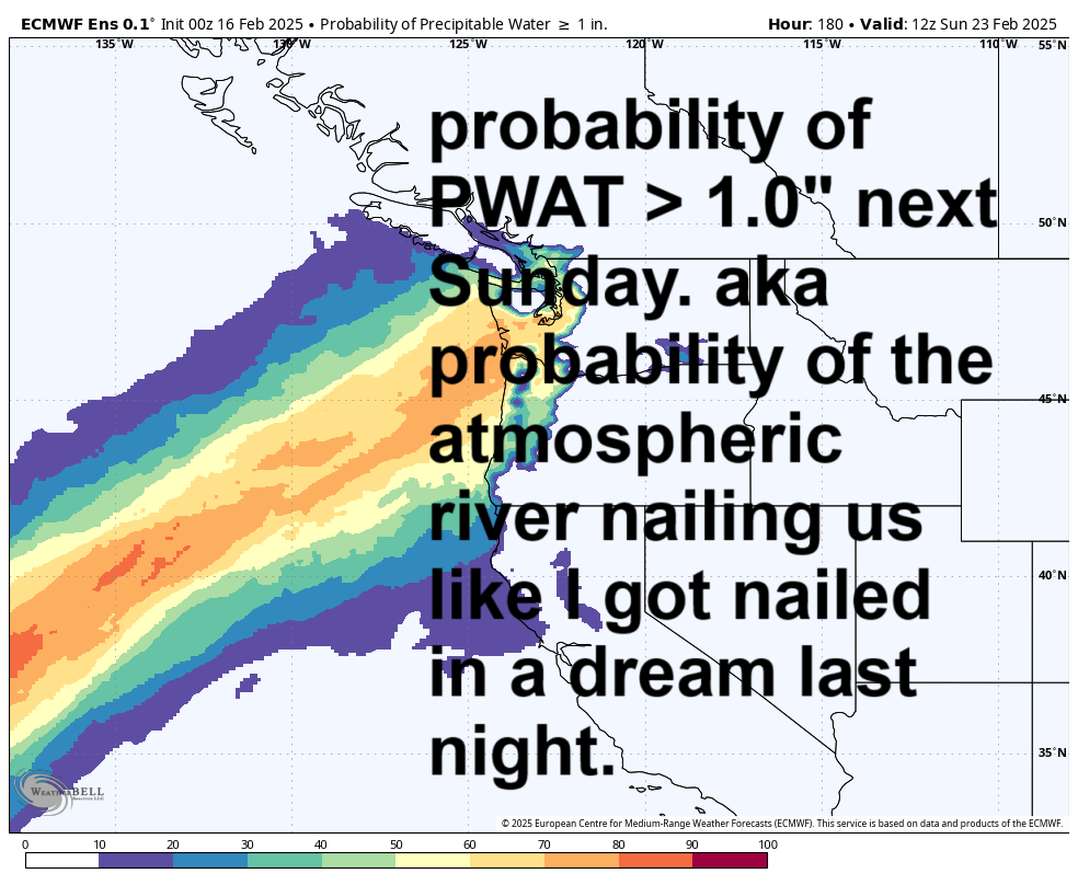
A low pressure system offshore drives Wednesday’s weather, but the path of that system isn’t yet defined. Generally speaking, it looks like we’ll see dense, damp snow all day long, and potentially up to a foot of it. Snow (probably) continues into Thursday morning before the sun pops out and takes over. Friday looks dry during the day and rainy at night. Warming is forecast into the weekend as sub-tropical air rides in from the SW. Models suggest the atmospheric river will be pointed north of us on Saturday and potentially at us next Sunday (70% chance). So, let’s keep a close eye on that – with temps forecast to be quite warm and available moisture high, a significant rain event is possible for the latter half of next weekend. Between now and then: lots of great times on the snow. See you out there!
Liking this forecast?
Was that helpful? I knew it was! Guess what? All of this crucial work – from your personal wind and snow reports to the invaluable TATAS updates – is made possible by my relentless efforts. Maintaining this labor of love isn’t easy. Each daily forecast takes hours. Website hosting, weather model access, and back-end admin work takes time and money. That’s where you come in.
YOUR CONTRIBUTION MAKES A DIFFERENCE
- SUPPORT ACCURATE, HYPER-LOCAL WEATHER FORECASTING
- ENABLE ACCESS FOR ALL, EVEN THOSE WITH LESS MEANS
- SUPPORT A COOL HUMAN WHO WORKS HARD SO YOU CAN PLAY
Take a moment to click one of the buttons below. Donate $19.99 or more (how much does this forecast enhance your life?) and get the email in your inbox. Whether it’s a renewing subscription (auto-renew) or a one-time donation, every contribution makes a real difference. Help me keep this labor of love alive, so we can all continue playing, commuting, and living in the Gorge with peace of mind and the best weather forecasts possible. Thank you!


Hood River, Oregon 97031


GORGE WIND FORECAST

Hi friends! Not much coming up here for a bit. There’s a shot at light westerlies on Monday and another possibility Wednesday, but don’t mark up your calendars yet. Sunday kicks off with about 20mph at Iwash (Rooster) Rock and 15mph at Stevenson. Iwash turns light westerly this afternoon and Stevenson holds at 5-10mph out of the east. River flow over the last 24 hours was 99-132kcfs, river temp is 38.12F, and high temp forecast is 42F with clouds and snain/drizzle.
Monday starts with W15mph at Iwash and E 5-10 at Stevenson. The wind turns westerly mid-morning at perhaps 12-15mph from Stevenson to Doug’s and 15-18mph from Avery to Rufus. High temp: 46F with clouds to the west and mostly clear sky to the east. Tuesday will be calm to start. Easterlies build during the day, but it’s unclear how strong they will get before dark. High temp: low 40s and cloudy. It’s possible we’ll see westerlies on Wednesday, but that depends on the path of an incoming low pressure system. Enjoy your alternative activities today!
BARE BONES HOOD RIVER WEATHER FORECAST
Clouds with snain this morning. Drizzle this afternoon. Temps start right at freezing and rise to the upper 30s or low 40s. Very light easterlies this morning with calm wind later. No rainbows. Monday will be cloudy with rain then mostly cloudy and showery. Temps start in the mid 30s and rise to the mid 40s. Calm wind early. Light to moderate westerlies later. 99% chance of rainbows. Tuesday will be cloudy with showery in the morning, dry midday, and rainy overnight with wet snow possible late. Temps start in the mid 30s and rise to the mid 40s. Calm wind early. Light to moderate easterlies later. 1% chance of rainbows.
TEMIRA’S AWESOME TRAVEL ADVISORY SERVICE
HYPERLOCAL WEATHER FORECAST FOR THE COLUMBIA GORGE
Good morning, neighbors! It’s a messy morning here in the Gorge with a delightful and invigorating mix of snow, sleet, snain, and freezing rain, all depending on where you are and what the temp profile is above you. With temps around the region and east of us ranging from 28-32 and temps aloft at 32F, we should see everyone pop above freezing by the afternoon. Next up: very wet weather all the way through Monday afternoon. Not much happens Tuesday daytime, and then we may see some snow Wednesday morning.
glenwood and the tatas eootd
Let’s check in with Glenwood, the center of the universe. It was 32F this morning, warmer than most places, and indicative of a warm layer aloft. I have no idea what p-type was happening there as I was writing this. Next, the TATAS Executive Order Of The Day: let’s rename Mt. Adams as Pahto and St. Helens as Loowit. We’ll check in with local Native leaders on their take on what we’ll rename Mt. Hood; all the online sources suggest that Wy’East may actually be a made-up White people name. Signed with a black fine-tip sharpie, as that’s best for capturing the ridges and outlines of volcanoes.
sunday, aka today
Today’s weather: a nasty, unpredictable, wet mix of precipitation types this morning everywhere east of Bonneville River-Blocking Large Construction Object. As we slowly warm a couple of degrees thanks to it being daytime and thanks to WSW 30kt wind aloft, we’ll all transition to rain. A few places could stick with freezing rain in the evening: the highest elevations of Parkdale, Middle Mountain, Sevenmile Hill, and maybe Snowden. Rain extends on and off all day and all night as far east as The Dalles with rain to Amayah’s early afternoon for a few hours. SW/Sherm: snain/freezing rain showers this morning and rain showers later. Today’s high temps rise to the upper 30s. Wind drops to from 20mph at Iwash this morning to LTW and holds at E 10mph near Stevenson.
monday, aka presidents’ day
Models seem to think we’ll all hover in the mid-30s tonight. With clear sky forecast east of the Cascade Crest, you’ll want to watch out for icy roads. We can’t rule them out in other locations too for the Presidents’ Day sunrise, which, incidentally, will be pretty somewhere thanks to a few breaks in the clouds. Rest of the day: showery as far east as The Dalles in the morning with heavy rain west of Hood River, which will F up your commute, so hopefully you have the kind of job that gives you holidays off. Sherman County sees steadier rain than south Wasco, which only gets a little. Wind will be E 10-15 in the usual spots to start and 15mph out of the west from Stevenson to Rufus in the afternoon. That shoves temps into the mid 40s and fires off some rainbows.
tuesday and beyond
Tuesday sees showers west of Mosier to start, dry weather most of the day, and heavy rain in the evening as far east as The Dalles and maybe beyond. The day should start above freezing for all of us, and it’ll finish in the mid 40s. Overnight Tuesday, the precipitation intensity may be intense enough, and temps may be just low enough, for accumulating snow. We shall look more closely as we get closer. After that: temps begin a slow climb towards 50F and beyond as sub-tropical air slithers in to the PNW. Periods of rain are forecast both Thursday and Friday. We may be dry, but muggy and warm Saturday, prior to a probable (70% chance) atmospheric river event of some sort on Sunday. Maybe. Sunday is a week out. Beyond that, models are quite certain we’ll have a few days of warmer weather with high temps at 50+. That sounds fun. Until then… safe travels. -TATAS
HEY! DON’T STOP READING! Is this community-focused forecast helpful to you? It sure is! It takes me a couple hours a day to write. Please join your friends and neighbors in contributing to keep it going. Venmo: @thegorgeismygym PayPal: twomirrors@gmail.com USPS: Temira / PO Box 841 / Hood River, Oregon 97031 You can test out the forecast subscription for a few days for free by clicking this link: https://subscribepage.io/YhevGc
