

MT. HOOD WEATHER FORECAST
Hey skiers and snowboarders! The groundhog says six more weeks of winter, and it sure looks like winter on the hill today. Cold weather with intermittent snowfall is the forecast for the next week or so. As we look farther out, namely into next weekend, we start to see at least some potential for adding higher amounts of snow. On the slopes right now: hardpack on the groom thanks to lots of skier traffic yesterday. Off the groom: a variable mix with areas of moguls. Nordic conditions: variable due to a weird period of freezing rain right at that elevation and also warmer snow temps during the recent snowfall. Wax: violet.
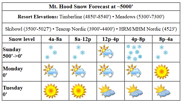
Today on the slopes you’ll find breezy conditions with light snowfall much of the day. Snowfall picks up to this afternoon for several hours before tapering off overnight. The snow level will be around 500′ all day with temps at 5000′ starting near 20 degrees and falling into the upper teens this evening. About 0.3” water equivalent (WE) is forecast today, for about 3” of fresh powder. Overnight, another 0.1” WE falls for another inch of new. Wind: WSW 25 this morning, W 40 this afternoon, and WSW 10 after midnight.
Liking this forecast?
Clouds and a few snow flurries are forecast on Monday with the snow level at 0′ and temps in the teens all day. Just a trace of new snow is in the cards. Wind will be variable to 10mph all day. Tuesday looks dry with the free air freezing level at 0′ and temps in the low double digits. A sunny morning gives way to a cloudy afternoon with a trace of snowfall overnight. Temps: teens. Wind: SW or S 10-15 all day and all night.
Wednesday brings another round of light snowfall with the snow level at 0′. Temps start around 10F, rise to the upper teens, and fall back to 10F or so overnight. An inch or so of snow is forecast during the day with 2-4” fresh blower powder overnight. Wind: SW 10-15 early, SW 15-25 for the rest of the day, and WSW 10-15 after midnight. Another cold, dry, partly cloudy day is forecast Thursday. Models hint at some snow on Friday and into the weekend, but there’s quite a bit of range in the forecasts right now. All-in-all, we’re looking at a great week for groom, parks, and Nordic. See you on the snow!
Was that helpful? I knew it was! Guess what? All of this crucial work – from your personal wind and snow reports to the invaluable TATAS updates – is made possible by my relentless efforts. Maintaining this labor of love isn’t easy. Each daily forecast takes hours. Website hosting, weather model access, and back-end admin work takes time and money. That’s where you come in.
YOUR CONTRIBUTION MAKES A DIFFERENCE
- SUPPORT ACCURATE, HYPER-LOCAL WEATHER FORECASTING
- ENABLE ACCESS FOR ALL, EVEN THOSE WITH LESS MEANS
- SUPPORT A COOL HUMAN WHO WORKS HARD SO YOU CAN PLAY
Take a moment to click one of the buttons below. Donate $19.99 or more (how much does this forecast enhance your life?) and get the email in your inbox. Whether it’s a renewing subscription (auto-renew) or a one-time donation, every contribution makes a real difference. Help me keep this labor of love alive, so we can all continue playing, commuting, and living in the Gorge with peace of mind and the best weather forecasts possible. Thank you!


Hood River, Oregon 97031


GORGE WIND FORECAST

Hi friends! Hope y’all had fun on the river yesterday. One more day of potentially just-enough west wind is forecast today before we fall into a colder – sub-freezing, mostly – east wind pattern. Sunday starts with pressures of 29.88/29.84/29.83 for light onshore gradients. As a weak system approaches mid-morning, we should see the wind bump up a bit. 15-18 from Stevenson to Swell seems reasonable in the 10am-1pm ish period. That’s followed by 19-23 from Avery to Rufus from about noon to 2pm. River flow over the last 24 hours was 71-123kcfs, river temp is 39.92F, and high temp forecast is 41F.
Monday starts calm. The wind picks up to E 15mph at Iwash (Rooster) Rock and Stevenson, and then it picks up to 10-20mph from Hood River eastward at cold air pushes in. High temp: 38F and cloudy with flurries. Tuesday sees 25mph east wind at Stevenson and Iwash with 10-20mph from Hood River eastward. High temp: 35F and partly cloudy. Stay warm out there!
BARE BONES HOOD RIVER WEATHER FORECAST
Clouds with showers and snain today. Temps start in the mid 30s and rise to the low 40s. Moderate westerlies. 99% chance of rainbows. Monday will be cloudy with morning snow flurries. Temps start in the mid 20s and rise to the upper 30s. Light to moderate easterlies. No rainbows. Tuesday will be partly cloudy then high overcast. Temps start in the mid 20s and rise to the mid 30s. Light to moderate easterlies. No rainbows.
TEMIRA’S AWESOME TRAVEL ADVISORY SERVICE (HYPER-LOCAL GORGE WEATHER FORECAST)
Good morning, neighbors! Somewhere between 500′ and 1000′ this morning, there’s a line. Step over it, and you go from rain to snow. Wishing for that line to go lower? You will get your wish this week thanks to a one-two punch of cold Alaskan air followed by cold continental air. Gazing deep into the future, models are very interested in promoting a big snowstorm. For now, we remain skeptical, but also hopeful.
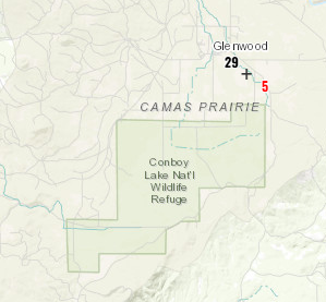
Let’s check in with Glenwood. It was 31 degrees there when I woke up, but now it’s 29 degrees. The dewpoint is 23, and they’re probably getting some light snowfall. Other areas are colder than Glenwood this morning, but we don’t actually care, because they’re not Glenwood, which is the center of the universe. Next requirement: the TATAS Executive Order of The Day: with a flourish of a metallic silver Sharpie, I do hereby declare that everyone gets two weeks of paid sick leave a year. You’re welcome!
SUNDAY
Sunday will be chilly and damp. Some areas will even be moist! You know, like the center of an eclair (you thought I was going to say, “twat”, didn’t you?). Sometime late morning, a somewhat wetter system moves in. With the snow level around 500′-1000′, we’ll see 1-3” of snow for some folks west of Goldendale (a trace to 1” there). Highest totals will be in Mill A, Trout Lake, Underwood, Parkdale, upper elevations of Mosier, York Hill, west side of Hood River and Odell, Stabler, and Husum. Along the river, we could see the rain turn to snow in the heaviest periods, but it’s unlikely to accumulate on the roads. Overnight, temps drop, and roads freeze up into poor facsimiles of skating rinks – slippery and icy, but not exactly smooth. Today’s high: 40ish. Wind: W 15-20 briefly from Stevenson to Hood River and then briefly a little later in the day from Avery to Rufus.
MONDAY
Monday starts with light snowfall from Hood River to The Dalles and icy roads everywhere. Snow stops falling by mid-morning, and we’ll be high, dry, and cloudy for the rest of the day. One exception: as easterlies pick up, communities in the east-side Cascade foothills (Dufur, for example) could see some light easterly orographic snowfall. Probably not more than an inch, but also not-not-snowing. Wind will be calm early, but as cold air surges in from the east in the afternoon, easterlies pick up to 10-20mph all the way from Iwash (dick) Rock to Arlington. High temp: upper 30s, if we’re lucky.
TUESDAY AND WEDNESDAY
A cold, dry day in Gorge heaven is forecast for Tuesday. Partly cloudy sky starts the day and allows temps to fall into the mid 20s along the river at dawn. High: mid 30s. Widespread easterlies continue as Canadian air pushes in from the NE. With cold air locked in place and a system moving in from the west, widespread light snowfall is forecast on Wednesday.
AND BEYOND
Generally speaking, the weather stays cold, cold enough for snow, for the extended period. That’s despite major differences between the ECWMF and the GFS in actual day-to-day temps and precipitation. Ice skating, already a go at Laurence Lake, is probably in the cards for the lower elevations eventually, especially if we can get some clear nights. Fingers crossed. Safe travels. -TATAS
HEY! DON’T STOP READING! Is this community-focused forecast helpful to you? It sure it! It takes me a couple hours a day to write. Please jump in a contribute to keep it going. Venmo: @thegorgeismygym PayPal: twomirrors@gmail.com USPS: Temira / PO Box 841 / Hood River, Oregon 97031 You can test out the forecast subscription for a few days for free by clicking this link: https://subscribepage.io/YhevGc
