

GORGE WIND FORECAST
today’s gorge wind forecast
Hi friends! Once again, it was great playing in the Nch’i Wana with you yesterday. Hopefully all of you had a great day with awesome swell rides! You’ll have another shot at it today as the Gorge wind forecast looks decent, and then two rest days, or at least rest days from wind sports. Go ride your road/gravel bike and see all the flowers! Plan to be back on the river for Wednesday for another big day. As of right now, ensembles are looking westerly again starting next Sunday, but there’s still a lot of range in the possible wind strength.
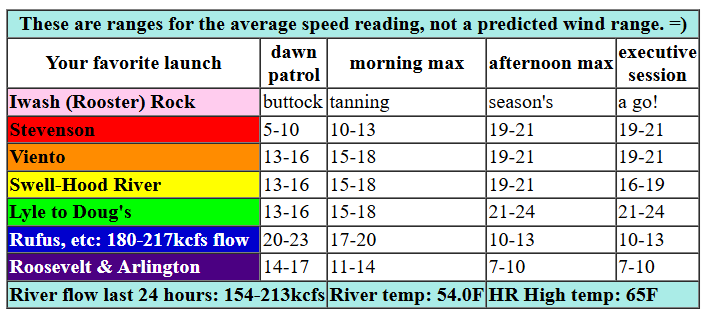
Sunday’s opening play was pressures of 30.23/30.13/30.09 with offshore high pressure at 1027mb. While there’s wind out in the desert this morning, it will fade this afternoon. If you’re not out there already, plan to stay close to home. Dawn Patrol wind was averaging 13-16mph most places with Stevenson and Arlington at 10mph or less. Models keep the wind at 13-16ish for a few hours this morning before nudging it up midday. We’ll see 19-21 from Stevenson to Doug’s for the early afternoon period with 21-24 likely between Lyle and Doug’s from mid-afternoon on. Avery may see 14-17 this afternoon, and areas to the east will drop below 10mph. Offshore high pressure is just strong enough that we could see reality outperform the models by 2-4mph from late morning on. River flow over the last 24 hours was 154-213kcfs (180-217kcfs at Rufus), river temp is 54.0F, and high temp forecast is 65F with sunny sky all day long.

tomorrow’s gorge wind forecast
Monday looks like a gorgeous day, but it won’t be windy. We’ll have light east wind at 10mph or less all day long. High temp: 75F and sunny. Tuesday doesn’t look much windier: light easterlies to start, 15mph midday at Stevenson and Iwash (Rooster) Rock, and 10mph in the evening.
extended Gorge wind forecast
Let’s move on to Wednesday. Models continue to trend stronger as they take into account an incoming cold front from the NW, offshore high pressure at 1024mb, and a significant cross-Cascade thermal gradient. As of right now, we’re looking at 17-20mph to start the day and 30mph to finish it. Details will become more clear as we get closer to the action, but I think it’s fine to take the risk of rearranging your schedule if you have the capacity to do so. After Wednesday, models contain more range, but they suggest we’ll see westerlies return the following Sunday and stick around for a while. That’s enough prognosticating for now. Y’all have a fantastic day on the river today!
Was that helpful? I knew it was! Guess what? All of this crucial work – from your personal wind and snow reports to the invaluable TATAS updates – is made possible by my relentless efforts. Maintaining this labor of love isn’t easy. Each daily forecast takes hours. Website hosting, weather model access, and back-end admin work takes time and money. That’s where you come in.
YOUR CONTRIBUTION MAKES A DIFFERENCE
- SUPPORT ACCURATE, HYPER-LOCAL WEATHER FORECASTING
- ENABLE ACCESS FOR ALL, EVEN THOSE WITH LESS MEANS
- SUPPORT A COOL HUMAN WHO WORKS HARD SO YOU CAN PLAY
Take a moment to click one of the buttons below. Donate $19.99 or more (how much does this forecast enhance your life?) and get the email in your inbox. Whether it’s a renewing subscription (auto-renew) or a one-time donation, every contribution makes a real difference. Help me keep this labor of love alive, so we can all continue playing, commuting, and living in the Gorge with peace of mind and the best weather forecasts possible. Thank you!


Hood River, Oregon 97031


JONES BEACH, SAUVIE ISLAND, & COAST FORECAST
Wind northerly unless otherwise indicated. For coast, it’s North/Central/South with the “central” at approximately Florence. Swell forecast from NWS for central coast. Sunday: 20-25/25/35+, W swell 7′ at 11 seconds. Monday: 20/20-25/25-30, W 4′ @ 10. Tuesday: 10-15/10-15/25, W 6′ @ 12. Jones Sunday: 16-19. Monday: LTW. Tuesday: 10-13. Sauvie Island Sunday: 16-19. Monday: 10-13. Tuesday light/variable.
BARE BONES HOOD RIVER WEATHER FORECAST
Clear sky today. Temps start in the mid 40s and rise to the mid 60s. Moderate westerlies. No rainbows. Monday will be clear with a few high clouds in the afternoon. Temps start in the upper 30s and rise to the mid 70s. Light easterlies. No rainbows. Tuesday will be partly high overcast. Temps start in the mid 40s and rise to the upper 70s. Light easterlies. No rainbows.
TEMIRA’S AWESOME TRAVEL ADVISORY SERVICE
HYPERLOCAL WEATHER FORECAST FOR THE COLUMBIA GORGE
THE DALLES, HOOD RIVER, WHITE SALMON, TROUT LAKE, STEVENSON, CASCADE LOCKS, PARKDALE, ODELL, HUSUM, BZ, MILL A, WILLARD, GOLDENDALE, RUFUS, ARLINGTON, boardman
Good morning, neighbors! Climate Change Spring continues its death grip on the Pacific Northwest with no rain in sight for at least 10 days and temps running 5-10 degrees above normal every day. Remember when it used to rain well into June? Remember Juneuary? Well, let’s make the most of this beautiful sunny weather, shall we?
Glenwood!!!
But first, let’s check in with Glenwood and other chilly spots. As expected, Glenwood is well below freezing this morning – 25 degrees. Parkdale is running anywhere from 31 to 38 degrees. It must be windy in The Dalles and Mosier, because nobody in those locations is anywhere near freezing. Next chance for frost: tonight as clear sky and light wind combine with very dry (but somewhat warmer) air for a better chance of widespread cold temps. Glenwood, Parkdale, Snowden, and cold spots in The Dalles and Mosier will want to watch temps closely. Odell – right on the edge, but probably okay. You can always check Erik Moldstad’s Fruit Frost Forecast (say that ten times fast) for more detailed info.
sunday’s gorge weather forecast
Okay. Sunday’s weather: gorgeous. Sunshine all day with temps rising to the mid 60s in the west and upper 60s to the east. Westerlies start at 15mph or so all the way from Viento to Rufus. East of Avery, the wind drops below 10mph this afternoon. West of Avery: 15-20mph this afternoon.
monday’s gorge weather forecast
As I said before, clear sky and calm wind overnight sets us up for a chilly Monday morning. Widespread upper 30s are in the cards with frost likely in the coldest spots. By afternoon, we’ll have temps in the mid 70s with light east wind. In the hills, easterlies pick up to 10-15mph.
Tuesday’s gorge weather forecast
Tuesday also looks warm. Add in a few high clouds. If models are spot-on, those high clouds will be in just the right spot early in the morning for a spectacular sunrise west of Mosier. With warmer temps aloft and widespread east wind stirring the pot early, daybreak temps should be in the 40s. Afternoon: right around 80 all through the land with easterlies at 15mph west of Hood River and 10-20mph in the hills. Spraying? Those easterlies will kick in early, so make your move early. High clouds increase in the afternoon west of The Dalles. If there’s a hole right where the sun goes down, we’ll have a darn fine sunset. I did NOT say “if there’s a hole where the sun doesn’t shine”, so get your mind out of the buttocks and the butt crack. Unless you like it there. In which case… be my guest… No, not in MY butt crack. That’s reserved already.
wednesday’s gorge weather forecast… and beyond
Wednesday looks warm (80) and partly cloudy with strong (30mph) west wind. Beyond that: continued dry, warm weather. It’s the kind of weather that doesn’t lend itself to dirty comments because it’s just too perfect. The next chance of rain isn’t until next Sunday, and even then, only about 50% of the ensemble members like the idea of precipitation. In the extended zone, models generally keep 850mb (5000′) temps well above freezing for the next 10-15 days (exception: next Wednesday night), meaning frost chances are minimal after Monday. Valuable Advice for Gardeners Inhabiting Neighboring Areas. Fuck it. I’m planting my tomatoes and peppers and 2453 Sherwood and 2085 Toboyek and 309.5 McCaslin and 76 Caldwell. Happy growing and safe travels. -TATAS
HEY! DON’T STOP READING! Is this community-focused forecast helpful to you? It sure is! It takes me a couple hours a day to write. Please join your friends and neighbors in contributing to keep it going. Venmo: @thegorgeismygym PayPal: twomirrors@gmail.com USPS: Temira / PO Box 841 / Hood River, Oregon 97031

One response to “Sunday: sunshine continues with on-and-off west wind in the Gorge”
Please confirm receipt of my payment for daily wind reports in my email.
So thankful you are providing this information